The Ionian Sea is easy to recognize between Italy and Greece, but less easy to outline precisely. Its northern boundary, the islands associated with its name and the depths shown on maps need different explanations. Start with the coast, then add the sea’s connections and underwater geography.
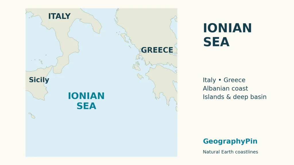
The Ionian Sea is part of the Mediterranean between southern Italy and western Greece, with southern Albania on its northeastern margin. It connects with the Adriatic through Otranto and the Tyrrhenian through Messina. Its deep basin includes Calypso Deep, while its precise northern limit depends on the geographic convention used.
How to use this article: Understand the northern limit, identify the main island landmarks, or check what the depth figures mean.
1. Where the Ionian Sea lies
The Ionian Sea occupies the Mediterranean waters between southern Italy and western Greece. Sicily and the Italian mainland frame its western side, while the Greek mainland and offshore islands form its eastern side. Southern Albania lies at its northeastern margin. The name identifies part of the Mediterranean Sea, not a separate ocean.
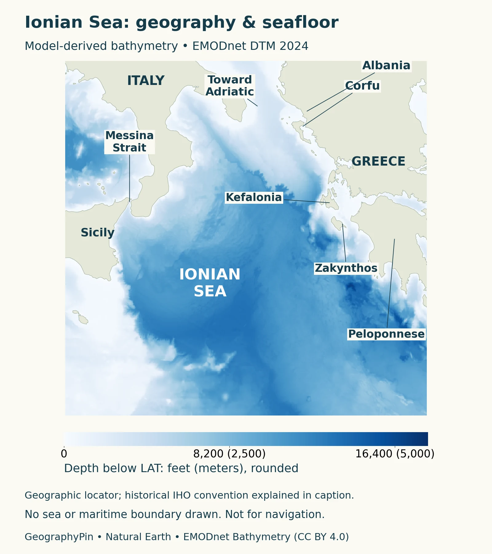
On a map of Italy, look beneath the heel and east of the toe of the boot. The broad indentation between them is the Gulf of Taranto. Across the water, the islands off western Greece provide a chain of landmarks leading toward the Peloponnese. These opposite coasts are the simplest starting points before tracing the smaller channels.
The Gulf of Taranto has shores in Calabria, Basilicata and Apulia. Taranto itself occupies a more intricate coastal setting: its old town lies on a small island between the Mar Grande and Mar Piccolo. Those names describe local water areas around the city, not alternative names for the entire gulf or the Ionian Sea.
2. Limits and the connection with the Adriatic
A historical line and a physical passage
The International Hydrographic Organization’s 1953 convention places the Ionian’s northern limit from the Butrint river mouth in Albania, via northern Corfu, to Cape Santa Maria di Leuca in Italy. Its southern limit joins Cape Matapan on the Peloponnese to Cape Passero in Sicily. These are naming limits for hydrographic publications, not national maritime borders.
The Adriatic Sea opens toward the Ionian through the Strait of Otranto. The strait is a physical channel; an organization’s line separating named seas is a convention. Locating the narrow crossing and drawing the historical IHO limit therefore answer different questions.
A 2023 Copernicus Ocean State Report describes Otranto as reaching approximately 2,625 feet (800 meters), between the southern Adriatic and the Ionian. That is a maximum-depth description of the passage, not its average depth or the depth along every crossing. The sill and surrounding relief influence how water moves between the basins.
Why Albania appears on Ionian coast maps
Albania’s National Tourism Agency explicitly describes Saranda, opposite Corfu, as an Ionian coastal city. This modern regional usage extends farther north along Albania than the historical IHO line at the Butrint river mouth. The difference concerns the extent of the coast assigned to each named sea; it is not a reason to erase Albania from the region.
For a coastal-country overview, southern Italy, western Greece and southern Albania are the relevant shores. For a boundary-based area calculation, first specify the convention. A precise country count without that explanation is less helpful than a map showing the actual coast and the line being used.
3. Islands, coasts and neighboring seas
The Greek islands along the eastern side
Corfu and Paxi help identify the northern island waters. Farther south are Lefkada, Kefalonia, Ithaca and Zakynthos. The Greek National Tourism Organisation groups these within the Ionian Islands, but the island group should not be confused with the whole sea: most of the water lies outside the narrow spaces between islands and mainland.
Kythira and Antikythira also appear in the broader Ionian Islands grouping used by Greek tourism sources. A cultural or regional grouping of islands does not necessarily match a hydrographic sea boundary. This is especially important at the southern end, where maps may organize neighboring Mediterranean waters differently.
| Landmark | What to look for |
|---|---|
| Gulf of Taranto | The Italian indentation bordered by Calabria, Basilicata and Apulia. |
| Corfu and Saranda | A Greek island and an Albanian mainland city facing the same northeastern coastal waters. |
| Kefalonia and Ithaca | Neighboring Greek islands farther south along the eastern side. |
| Strait of Messina | The channel between northeastern Sicily and Calabria. |
Messina is the route toward the Tyrrhenian
The Strait of Messina connects Ionian and Tyrrhenian waters between Sicily and Calabria. ISPRA’s geological field guide describes this water exchange when comparing the modern strait with its ancient sedimentary record. On a regional map, it is the narrow western connection, not the broad opening toward the Adriatic.
The Aegean Sea lies on the other side of mainland Greece. Keeping Sicily, the Greek mainland and the Peloponnese in view helps distinguish the surrounding seas without treating every Greek island as an Aegean island.
4. A deep Mediterranean basin with changing circulation
What bathymetry adds to the coastal map
A coastline map shows where the Ionian lies, but bathymetry reveals the shape of the submerged basin. Read the depth colors separately from the land labels: a gulf, island or cape is a surface landmark, while a deep depression is a feature of the seafloor below.
The map above uses a 0.01-degree export of EMODnet’s 2024 terrain model, whose native grid is 1/16 arc-minute. Colors represent modeled depths below Lowest Astronomical Tide, not a new expedition’s soundings.
EMODnet combines surveys and other terrain models, including GEBCO gap filling. Continuous depth shading therefore does not mean every point was directly sounded.
Calypso Deep and the meaning of a depth figure
Calypso Deep, southwest of the Peloponnese, reaches roughly 16,700 feet (5,100 meters). A February 2020 expedition report distinguishes its submersible result from the ship’s multibeam-sonar result: the former was 16,762 feet (5,109 meters), with a reported uncertainty of about 3 feet (1 meter). That is an attributed survey result, not a claim that every source or terrain model reports exactly the same number.
The measurement point is not representative of the entire Ionian floor. Nor should the darkest cell on a generalized map automatically be labeled the sea’s exact maximum. A narrow depression can be represented differently as the grid resolution, source coverage and processing change.
The northern gyre does not always turn the same way
CNES’s AVISO+ account describes alternating clockwise and counterclockwise circulation states in the northern Ionian, with transitional patterns between them. These changes affect the routes taken by water entering from the western Mediterranean and the strength of the eastward flow across the basin.
This variability matters beyond the Ionian itself. Research summarized in the Copernicus Ocean State Report links northern Ionian circulation to the types of water entering the southern Adriatic. The basins exchange water as well as sharing a geographic boundary; their conditions cannot be understood as entirely separate systems.
For that reason, the locator is not a permanent current map. A circulation illustration must identify whether it shows a particular observation period, a model average or a conceptual pattern. None of those is a forecast of currents at an island or harbor today.
5. How to compare Ionian maps and measurements
Start with the map’s purpose. A locator helps identify shores and neighboring seas; a hydrographic boundary establishes a naming convention; a bathymetric map represents underwater relief. One image can combine these layers, but they still describe different things.
When comparing depth figures, keep the method attached to the number. A submersible observation, a ship survey and a regional grid cell are not interchangeable. Read the stated uncertainty and vertical reference rather than assuming that more decimal places mean greater accuracy.
The same care applies to area and coastline figures. A sea’s surface area depends on its selected limits, while shoreline length changes with the level of detail used to trace islands, bays and headlands.
What Did We Learn Today?
The Ionian belongs to the connected Mediterranean system, with Italy and Greece forming its main opposite shores and Albania at its northeastern edge. Physical passages, historical sea limits and island groupings are related but different. Bathymetry adds the deep basin beneath this coastal geography, while survey methods explain why depth figures need context.
Sources & Data Notes
The boundary discussion uses IHO’s 1953 naming convention alongside current Albanian regional terminology. Neither establishes maritime jurisdiction. Calypso’s approximate depth is distinguished from the attributed February 2020 submersible measurement; unit conversions are rounded. The circulation description concerns documented variability, not current conditions.
- IHO (1953), Limits of Oceans and Seas, page 17
- Albanian National Tourism Agency: Saranda
- Ionian Sea Port Authority: Gulf of Taranto
- Greek National Tourism Organisation: Ionian Islands
- ISPRA: Messina Strait geological field guide
- Di Biagio et al. (2023): southern Adriatic connections
- Caladan Oceanic: February 2020 Calypso survey report, archived by NOAA
- CNES AVISO+: Ionian circulation
- EMODnet: bathymetry methods and products
- Natural Earth: public-domain map data