The Aegean is crowded with familiar island names, but knowing an island’s name is not always enough to place it. A few island groups, the two mainland shores and the correct sequence of northern straits make the regional map much easier to understand.
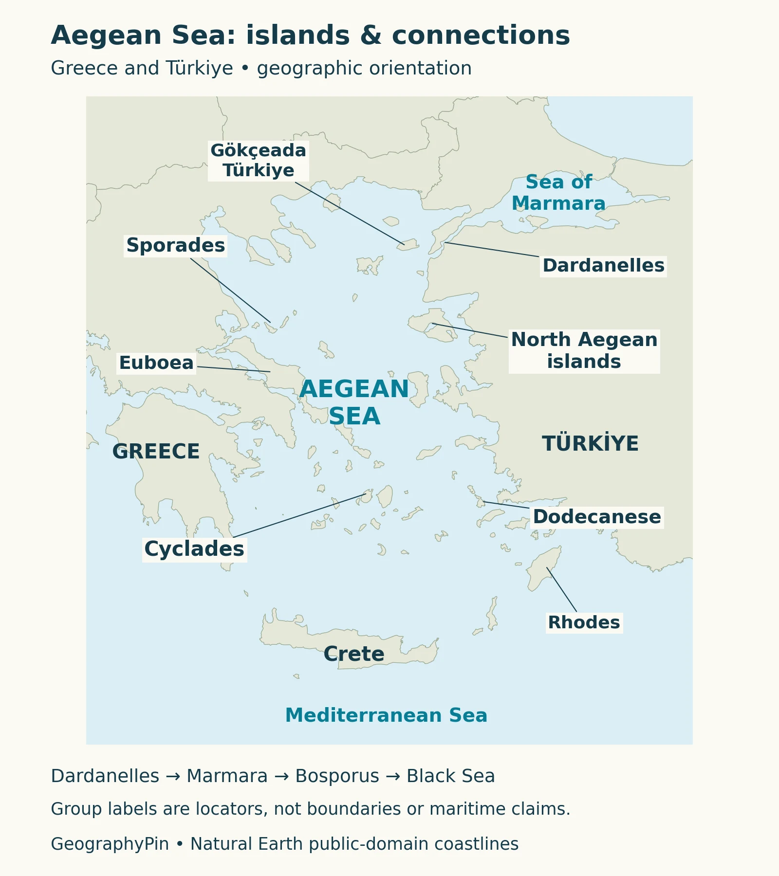
The Aegean Sea is part of the eastern Mediterranean between Greece and Türkiye. Its islands include the Cyclades, Sporades, North Aegean group and Dodecanese, alongside Turkish islands such as Gökçeada. The Dardanelles connect it with Marmara, while passages around its southern island rim lead into the wider Mediterranean.
How to use this article: Compare the island groups, follow the sea connections, or look below the surface at the underwater basins.
1. Where the Aegean Sea lies
A map between two mainland shores
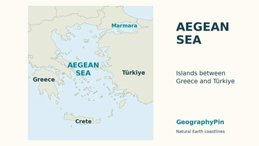
The Aegean occupies the space between mainland Greece to the west and Türkiye’s Anatolian coast to the east. Crete is a major southern landmark, while the northeastern corner leads toward the Dardanelles. Islands interrupt the open water throughout the region, so the sea is better understood as a connected basin threaded with passages than as an empty oval.
The Aegean is part of the Mediterranean Sea. Calling it Aegean rather than Mediterranean gives a more specific location, just as a regional place name can sit within a larger one. It does not make the Aegean a separate ocean; the world ocean map shows the broader setting.
2. Island groups that make the map easier to read
Four useful regional groupings
Island names become easier to place when grouped geographically. The table uses familiar groupings from the Greek National Tourism Organisation, not a new division of the sea into administrative or legal zones. Selected examples illustrate each group rather than attempting to count every island and rock.
| Grouping | Map position and examples |
|---|---|
| Cyclades | Central island cluster; Naxos, Paros, Mykonos and Santorini |
| Sporades | Off the eastern Greek mainland; Skiathos, Skopelos, Alonnisos and Skyros |
| North Aegean islands | Northern and eastern grouping; Lesbos, Chios, Samos and Limnos |
| Dodecanese | Southeastern grouping; Rhodes, Kos, Karpathos and Patmos |
The Cyclades take their name from an imagined circle around Delos. That name is a useful orientation cue, not an instruction to draw a precise circular boundary. The group also contains varied landscapes: Andros differs from the familiar dry-island image, while Milos and Santorini have prominent volcanic features. One postcard scene cannot represent every Cycladic island.
The Sporades lie closer to the eastern mainland. Their position helps distinguish them from the central Cyclades: start at the mainland shore, then trace the separate islands eastward rather than looking for one continuous island chain.
North Aegean islands is used here as a broad geographic grouping. GNTO’s list includes islands spread across the northern and eastern Aegean, rather than one compact chain. Do not treat this tourism grouping as an exact outline of Greece’s administrative North Aegean Region, or assume every island in the northern sea belongs to that region.
The Dodecanese occupy the southeastern part of the island geography. Rhodes and Kos are helpful reference points, but the group includes other islands with their own positions and landscapes, including Karpathos and volcanic Nisyros. A regional group name is not a complete description of the geology of every member.
3. Greek and Turkish islands
Gökçeada and Bozcaada near the Dardanelles
Many familiar Aegean destinations are Greek, but not every Aegean island belongs to Greece. Türkiye’s official tourism site identifies Gökçeada and Bozcaada as Turkish islands near the mouth of the Dardanelles. Gökçeada is labeled explicitly on the map so that a general Greek-island grouping does not obscure this distinction.
Farther along the Turkish coast, Cunda, also called Alibey Island, lies near Ayvalık and is linked to the mainland by a road bridge. Gökçeada and Bozcaada are therefore not the only Turkish examples, and the four Greek groupings in the table are not a complete inventory of all Aegean islands.
Read island names, country labels and sea names as different layers of information. Proximity to a mainland shore alone is not a reliable way to assign an island’s sovereignty. The locator identifies geography; it does not attempt to settle maritime boundaries or draw exclusive economic zones.
4. Connections with Marmara, the Black Sea and the Mediterranean
Follow the passages in the correct order
From the northeastern Aegean, the connection toward the Black Sea runs through the Dardanelles → Sea of Marmara → Bosporus → Black Sea. The Bosporus therefore does not open directly into the Aegean. Marmara is the intervening sea, and the Dardanelles are the Aegean-facing passage.
To the south, passages among the island chain around Crete connect the Aegean with the wider eastern Mediterranean. The International Hydrographic Organization’s 1953 naming convention traces a southern limit through Rhodes, Karpathos, Crete, Antikythera and Kythera. Those islands help explain the southern outline without suggesting a continuous land barrier.
A named-sea limit and a current are not the same thing. Water can move across a hydrographic naming line, and movement through a strait can differ with depth. The map’s connection sequence describes geography, not a forecast that every parcel of water moves along the arrows in one direction.
Black Sea water reaches the northern Aegean after passing through the Turkish Straits system. A 2024 study describes its influence as a comparatively less salty surface layer. That connection helps explain why the northern Aegean can have different water properties from the southern basin rather than behaving as one uniform pool.
5. A seabed of shelves, troughs and separate basins
The island pattern continues underwater
Islands show only the parts of the landscape above sea level. Between them, the Aegean contains shallower shelves and sills as well as deeper troughs and basins. A sill is an underwater threshold: it can restrict exchange between deep basins even when their surface waters remain connected.
Zervakis and Georgopoulos’s study of 1997–1998 observations describes the relatively shallow Cyclades plateau as separating broad northern and southern Aegean basins. Within the northern part, further sills and deeper sub-basins create additional divisions. The seabed is therefore more complicated than a single bowl beneath the island groups.
This matters for water circulation. A passage may allow exchange in its upper layers while limiting movement of much deeper water. A flat locator map cannot show that vertical structure, and counting islands does not reveal how the underwater basins communicate.
The map above is a coastline locator, not a depth map. The central island cluster can help orient the reader to the Cyclades plateau, but the water’s blue color does not imply equal depths between all islands.
6. Tectonics and the waters above the seabed
Volcanic islands within a larger tectonic setting
The Aegean’s geology involves both crustal extension and subduction. Extension means the crust is being stretched; subduction occurs where one tectonic plate descends beneath another. These processes can coexist across a region rather than requiring every part of it to behave in the same way.
A geological synthesis hosted by the U.S. Geological Survey places Santorini within this combined setting. It describes eastern Mediterranean seafloor descending beneath the Aegean along the Hellenic system south of Crete, with Santorini among the volcanoes associated with that subduction. The volcanic arc and the island-group names describe different things.
It would therefore be misleading to call every Aegean island a volcano. A volcanic example such as Santorini explains one part of the regional story, not the origin of every coastline on the map.
Above that seabed, the water’s structure has its own controls. Relatively less salty Black Sea-origin surface water can help maintain layering in the north and inhibit deep mixing. The 2024 research examined changes in that influence; it does not establish that a recent observation will continue indefinitely. Geography sets the framework, but water conditions vary within it.
What Did We Learn Today?
Island groups make the Aegean easier to locate, but they are not maritime boundaries and do not make every island Greek. The Dardanelles–Marmara connection explains the route toward the Black Sea, while underwater thresholds and tectonic processes reveal a regional geography that a coastline map alone cannot show.
Sources & Data Notes
Island groupings are geographic orientation aids, not exhaustive inventories or jurisdictional boundaries. The map uses Natural Earth coastlines without depth shading. IHO’s historical sea-name convention is kept separate from maritime claims. Research dates identify the cited observations and publications, not current hazard or water-condition forecasts.
- IHO: Limits of Oceans and Seas (1953), printed page 18, Aegean and neighboring waters.
- Greek National Tourism Organisation: Cyclades, group identity and selected islands.
- Greek National Tourism Organisation: Sporades, island grouping.
- Greek National Tourism Organisation: North Aegean islands, broad geographic grouping.
- Greek National Tourism Organisation: Dodecanese, southeastern group and examples.
- GoTürkiye: Aegean islands, Turkish island identities and locations.
- Zervakis and Georgopoulos (2002), northern Aegean seabed and 1997–1998 observations.
- Mamoutos and colleagues (2024), Black Sea water influence in the northern Aegean.
- Druitt and colleagues (1999), geological and tectonic setting of Santorini, USGS publication record and abstract.
- Natural Earth terms of use, public-domain basemap data; original cartography by GeographyPin.