Canberra became Australia’s capital through a political compromise and a deliberate planning process. Rivalry between Sydney and Melbourne favored a new federal capital, while the Constitution required a site in New South Wales at least 100 miles (about 160 km) from Sydney. Parliament selected the Canberra region in 1908 and moved there in 1927.
How to use this article: Locate Canberra on the map, unpack the constitutional distance rule, or compare the two Parliament Houses.
1. A new nation needed a federal capital
Australia federated on January 1, 1901, bringing six colonies together in a Commonwealth. The new national government needed somewhere to meet and work. Choosing an existing major city, however, would also favor one colony’s successor state over another.
Sydney and Melbourne were the central rivals in that debate. The solution was not to alternate the national capital between them. It was to establish a separate federal seat of government. The National Capital Authority’s history explains how the competition between New South Wales and Victoria shaped that decision.
What the 100-mile rule actually meant
Section 125 of the Constitution set the geographical framework: the seat of government was to be in territory acquired by the Commonwealth, within New South Wales, and at least 100 miles (about 160 km) from Sydney. Parliament was to meet in Melbourne until it met at the new seat of government.
This was a minimum-distance requirement, not an instruction to build exactly 100 miles away. Nor did it say the capital had to be halfway between Sydney and Melbourne. A restriction on where a site could be chosen is different from a formula identifying a single point.
The arrangement separated two decisions. First, the federation agreed on the rules for a future capital. Later, Parliament had to select the actual district. Canberra’s story begins with that political and constitutional process, not with an architect drawing a city on an unrestricted blank map.
2. Where Canberra sits on the map
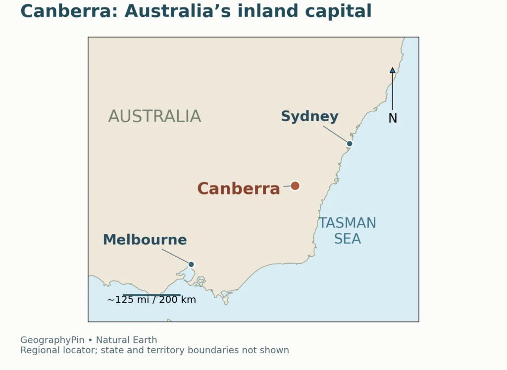
Canberra is inland in southeastern Australia, southwest of Sydney and northeast of Melbourne. Today it is in the Australian Capital Territory, usually shortened to ACT. It is not a coastal port, and its importance comes from its national-government role rather than from being the country’s geographical center.
The compromise was political, not an exact midpoint
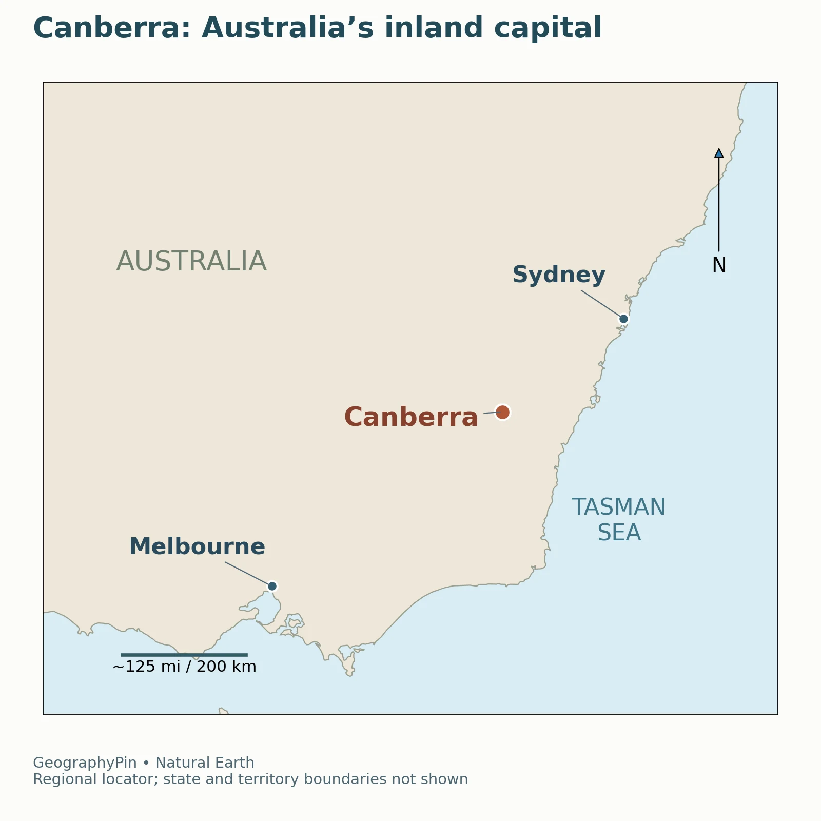
The regional map places the three cities in their real geographical relationship. Canberra lies closer to Sydney than to Melbourne; “between the two cities” should not be turned into “equally distant from both.” The map is a locator, not a driving route, and the lines leading from labels to city dots do not represent roads.
The ACT and Canberra are also not interchangeable names for precisely the same thing. Canberra is the city; the ACT is the territory containing it and the surrounding landscape. State and territory boundaries are omitted from this small regional map so the city locations remain easy to read.
Why the Constitution mentions New South Wales
The historical requirement to choose a site within New South Wales can sound confusing when Canberra is described as being in the ACT today. The missing step is the transfer of territory to the Commonwealth.
Geoscience Australia records that the Federal Capital Territory was formally transferred from New South Wales on January 1, 1911. The name Australian Capital Territory followed in 1938. Thus, the location was selected from land in New South Wales, but Canberra is not now administered as a New South Wales city.
For comparison with other national seats, see GeographyPin’s world capital cities guide. The Canberra–ACT distinction is a useful example of political geography: a city’s physical position can stay the same while the jurisdiction governing the surrounding land changes.
3. Why this district won the competition
The choice was not simply “Sydney or Melbourne, so pick Canberra.” Parliament and governments considered other sites and debated access, water and landscape. Dalgety was an earlier favored choice, but the New South Wales government opposed its remoteness and wanted a location closer to Sydney.
The Yass–Canberra district emerged as an acceptable compromise, and the 1908 decision established the region for the national capital. The National Capital Authority’s account of the site selection describes the alternatives and the political negotiations rather than a single automatic geographical calculation.
Water, hills and room for a planned city
Surveyor Charles Scrivener examined the district for an appropriate city site. The Canberra valley offered a landscape of hills and the Molonglo River, with opportunities to incorporate water into the future capital. The NCA’s lake history explains the attention paid to water catchments and contour surveys.
These physical considerations mattered after the constitutional rules had narrowed the search. A capital needs more than a politically acceptable address: it also needs a workable setting for buildings, movement, public spaces and water infrastructure.
Some historical advocates praised a “bracing” climate and believed cool conditions improved people’s abilities. That was a belief of the period, not a scientific explanation for why one climate produces better government. Water availability, accessibility and the shape of the site are more concrete elements to distinguish from those historical attitudes.
Planned did not mean uninhabited
Calling Canberra a planned capital does not mean its landscape had no people or history before the federal project. The region has longstanding Aboriginal connections, and the National Capital Authority acknowledges the Ngunnawal people as the ACT’s traditional custodians while recognizing others with connections to the region.
The twentieth-century decision concerns the establishment and design of a federal city. It should not be confused with the beginning of human presence in the area.
4. Designing a capital around its landscape
An international competition selected a plan for the city. In 1912, Walter Burley Griffin’s entry was announced as the winner. Marion Mahony Griffin worked with him on the design and produced the drawings that presented the proposal. Both roles matter: naming the official winning entrant should not erase her contribution.
The National Archives of Australia records her work on the drawings, while the NCA describes their collaboration on a city integrated with the surrounding hills and valleys.
The city plan was not just a street grid
The Griffin plan used geometric relationships, major views and the existing landscape. Lakes along the Molonglo Valley and a triangular central national area were important parts of the design. Hills helped organize the placement of institutions and the direction of important vistas.
This is why Canberra’s layout is more than a collection of government buildings. The relationship between open space, water, roads and hilltops was part of the capital’s intended character. The landscape helped structure the plan rather than merely surrounding it.
A winning design was not the same as a completed city. Funding constraints, the First World War and administrative disputes slowed and changed the project. Walter Burley Griffin left his Canberra role in 1920; the city continued to develop through later decisions and institutions.
Lake Burley Griffin came much later
The familiar lake was not already in place when the capital was named in 1913. It is an artificial lake formed by impounding the Molonglo River at Scrivener Dam. The dam’s valves were closed in 1963, and the lake became a reality in 1964. The NCA records the official commemoration of its filling on October 17, 1964.
The Scrivener Dam history shows how the earlier planning vision depended on later engineering. The lake visible in modern descriptions of Canberra therefore belongs to a different stage of the city’s development from the original site selection or naming ceremony.
5. The dates that are easy to confuse
There is no need to force Canberra’s history into one ambiguous “became capital” date. Selection, territorial transfer, naming, construction and the move of Parliament were separate milestones.
| Date | What happened | Why the distinction matters |
|---|---|---|
| 1901 | Australia federated; the federal Parliament met in Melbourne | The national government existed before Canberra was built |
| 1908 | The Yass–Canberra region was selected | This was the site decision, not the opening of Parliament in Canberra |
| January 1, 1911 | The Federal Capital Territory was transferred from New South Wales | The federal territory preceded the city’s formal naming |
| 1912 | Walter Burley Griffin’s design won the competition | Choosing a plan did not complete the city |
| March 12, 1913 | Canberra was formally named | Naming was a different milestone from parliamentary relocation |
| May 9, 1927 | The provisional Parliament House opened | Parliament moved from Melbourne to Canberra |
| 1964 | Lake Burley Griffin filled and was formally commemorated | The central lake was a later part of the capital’s development |
| May 9, 1988 | The present Parliament House opened | The national capital did not move again; Parliament changed buildings within Canberra |
The dates are drawn from the NCA, Geoscience Australia and the Parliamentary Education Office’s account of Parliament House.
Old Parliament House and the present building
Parliament’s move in 1927 was to the building now called Old Parliament House. It served until 1988, when the present Parliament House opened on Capital Hill. The two buildings represent different phases of the same national capital, not two different capital cities.
The current Parliament House was designed by Mitchell/Giurgola & Thorp. It should not be attributed to Walter Burley Griffin simply because his city plan shaped Canberra’s broader setting. The Parliamentary Education Office explains how the later building responded to the landscape and to aspects of the earlier planning vision.
Frequently Asked Questions
Was Melbourne Australia’s capital before Canberra?
Melbourne was the temporary home of the federal Parliament from 1901 to 1927 while a separate federal capital was selected and developed. That is the precise meaning behind descriptions of Melbourne as the earlier or temporary capital; it was not intended to remain the permanent federal seat.
Is Lake Burley Griffin a natural lake?
No. It was created by damming the Molonglo River at Scrivener Dam. Although water was part of the early capital plan, the lake was filled in 1964, decades after Canberra was named.
What Did We Learn Today?
Canberra is Australia’s capital because a political compromise led to a purpose-built federal seat of government, selected within constitutional geographical limits. The city is inland in the ACT, not at an exact midpoint between Sydney and Melbourne. Its history separates the 1908 site decision, 1913 naming and 1927 parliamentary move, while the Griffin planning vision, the later lake and the present Parliament House belong to different stages of a continuing city-building process.
Sources & Data Notes
The timeline separates site selection, territorial transfer, naming and parliamentary relocation rather than assigning them one date. The constitutional distance is given in its original miles, with a rounded metric equivalent. The original maps use generalized Natural Earth geometry and city points; no state boundary, constitutional exclusion zone, driving route or urban extent is inferred from them.
- National Capital Authority: Canberra, the Seat of Government
- National Capital Authority: The Siting and Naming of Canberra
- Geoscience Australia: Australia’s state and territory borders
- National Capital Authority: Walter Burley Griffin
- National Archives of Australia: Portrait of architect Walter Burley Griffin
- National Capital Authority: Lake Burley Griffin
- National Capital Authority: Scrivener Dam
- Parliamentary Education Office: Australia’s Parliament House
- Natural Earth: data reuse terms