The Niger River’s route is easy to misread: it starts in Guinea, curves far into the West African interior, and reaches the Atlantic in Nigeria. Along the way, an inland delta can be mistaken for its mouth, while the country called Niger can be mistaken for the whole river’s setting.
The Niger River flows from Guinea through Mali and Niger, along part of the Benin border, and through Nigeria to the Gulf of Guinea. Its inland delta is in Mali; its coastal delta is in Nigeria. The Benue joins its lower course, while the wider basin extends beyond the main river corridor.
Find your bearings: Follow the source-to-sea route, compare the two deltas, or distinguish river countries from basin countries.
1. Follow the Niger River from source to sea
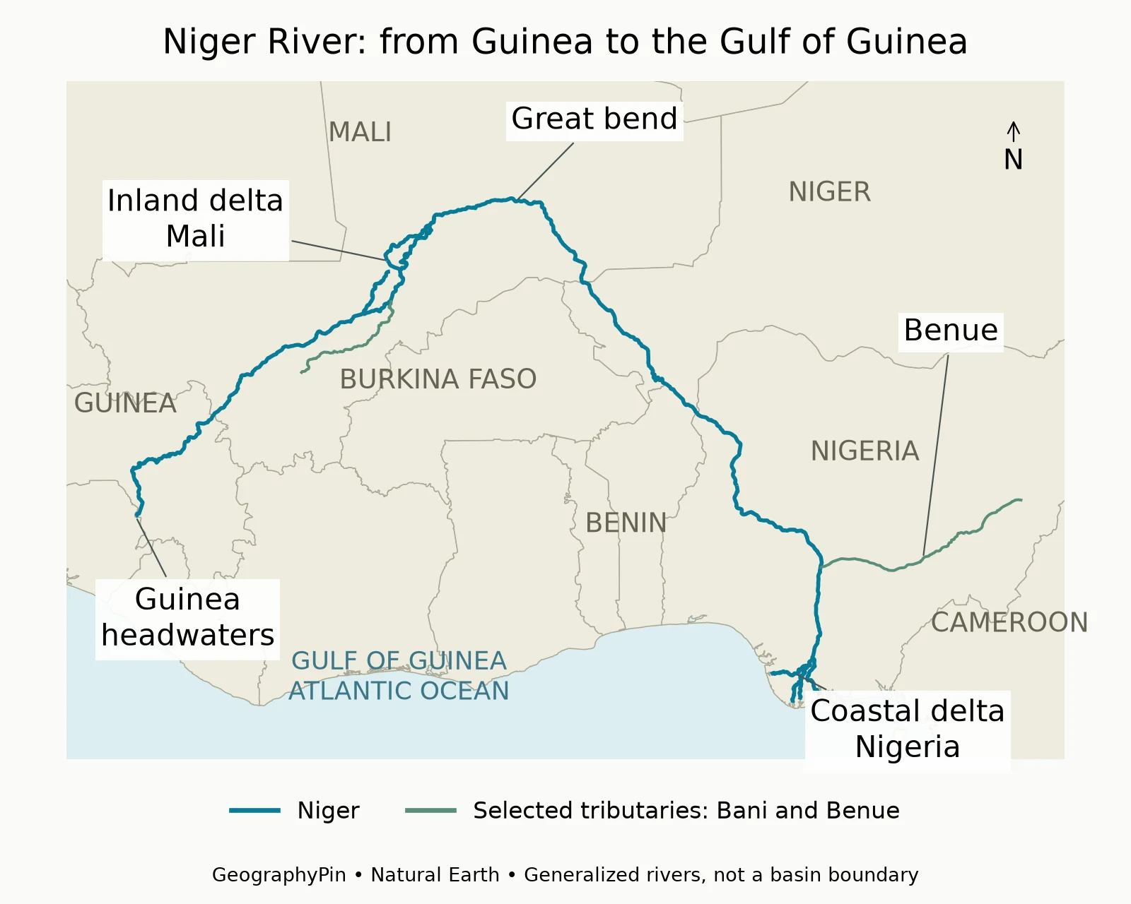
A long route through the interior
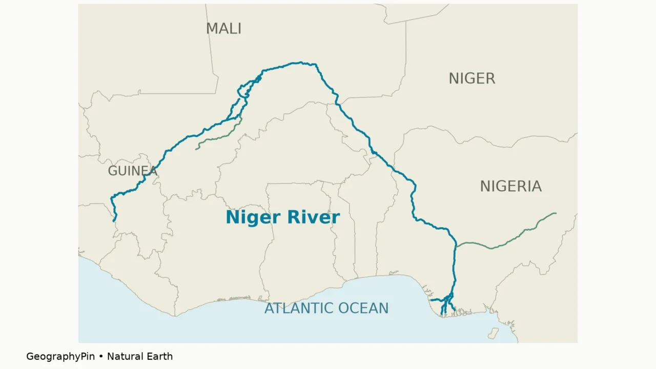
The Niger begins in the highlands of Guinea, near Sierra Leone. Instead of taking a short route west to the Atlantic, it runs northeast into Mali. It then curves across the interior of West Africa before turning southeast through Niger and toward Nigeria.
Follow the blue line rather than the spelling of the country names. The river is already a substantial cross-border system before it reaches the country of Niger. Farther downstream, it forms part of the Niger–Benin frontier before entering Nigeria. Its final outlets are on Nigeria’s coast, not on the coast of Guinea where the journey began.
In Nigeria, the Benue joins the Niger at Lokoja. Below that junction, the combined river runs south and divides into channels in the coastal Niger Delta, opening into the Gulf of Guinea. The gulf is part of the Atlantic Ocean. Guinea the country and the Gulf of Guinea are different geographic entities, even though both appear in a source-to-mouth description.
Which countries does the river touch?
| Country | Relationship to the main river |
|---|---|
| Guinea | Headwaters and upper course |
| Mali | Inland delta and great bend |
| Niger | Middle course, including the Niamey reach |
| Benin | River forms part of the border with Niger |
| Nigeria | Lower course, Benue junction and coastal delta |
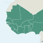
This is a list of countries crossed or bordered by the main channel, not a list of every country contributing water to the river system. Benin’s inclusion should not be read as a claim that the river crosses the country from north to south. For the surrounding political geography, use our West Africa countries map.
2. Why does the Niger make such a large bend?
Downstream is not a compass direction
The great bend in Mali is the route’s most recognizable feature. The upper river approaches from the southwest, travels toward the Sahara’s southern margin, and bends back toward the southeast. A north-up map can make this look like the river is going the wrong way, particularly when its eventual outlet lies far to the south.
Rivers respond to the slope of the land and the structure of their drainage network, not to the direction of the nearest coastline. Flowing northeast is no more unusual in principle than flowing south: both can be downhill. The parts and flow of a river are best understood in terms of upstream and downstream rather than top and bottom of a page.
The Niger’s course also connects markedly different environments. Its upper catchment receives water in the Guinea Highlands; farther downstream, the river passes through much drier country. Local dryness beside a channel therefore does not tell the whole story of where its water originated. Rain falling upstream can sustain a wetland or river reach beyond the area where that rain fell.
3. The inland delta is not the river’s mouth
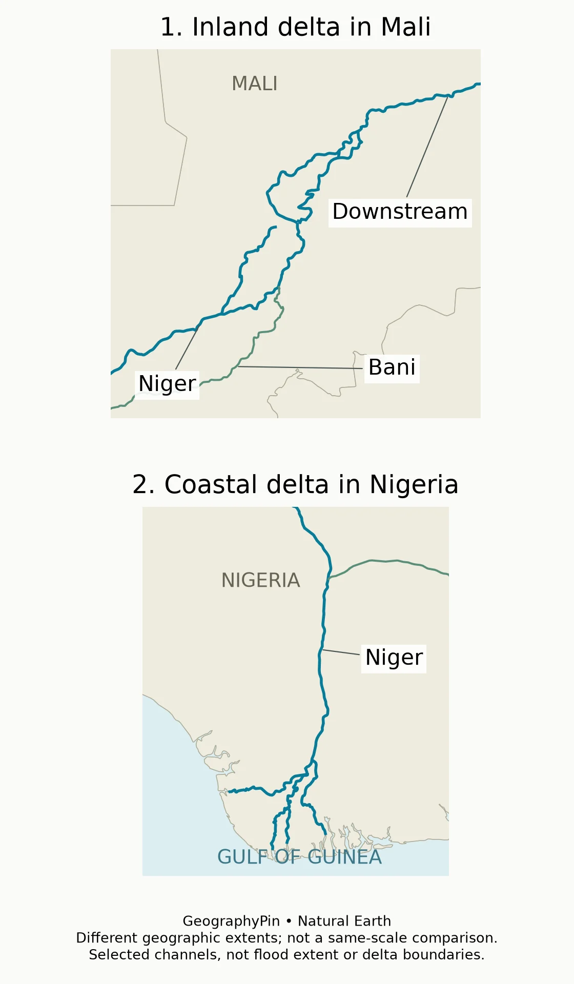
One river, two very different delta settings
The Inner Niger Delta, also called the Inland Niger Delta, lies in Mali. Here, the Niger and Bani supply a low-gradient landscape of channels, lakes, marshes and seasonally flooded ground. The Niger does not end there: water continues downstream beyond the wetland toward the great bend.
The coastal Niger Delta lies much farther downstream in Nigeria. It is the river’s maritime outlet, where its channels reach the Gulf of Guinea. Calling both landscapes deltas does not make them interchangeable, and a photograph captioned simply “Niger Delta” may need more location information.
| Question | Inland delta | Coastal delta |
|---|---|---|
| Country | Mali | Nigeria |
| Setting | Interior floodplain and wetland network | Atlantic coastal outlet |
| Does the Niger continue beyond it? | Yes, downstream through the interior | Its distributaries reach the sea |
| Useful map clue | Bani–Niger connection and inland channels | Gulf of Guinea coastline |
Why the inland delta changes appearance
Seasonal upstream rainfall sends a flood pulse toward the inland delta. Water spreads across low ground, connecting channels and wetlands that look very different in a drier season. USGS describes this recurring floodplain setting; NASA’s 2022 satellite comparison shows the contrast between relatively dry May conditions and greener, wetter conditions in November of that year.
The timing and extent vary. A wet-season satellite image is not a permanent shoreline map, while a dry-season image does not show the full area that can become inundated. Likewise, the boundary of a protected wetland site is an administrative designation, not necessarily the edge of water on a particular date.
These seasonal connections matter to fishing, grazing and rice cultivation. The value of the floodplain is not captured simply by counting how many miles of channel appear on a map. Water spreading across the surrounding land is part of the system’s normal operation, although an extreme flood can also cause damage.
4. The Niger basin is larger than the river corridor
Main channel, tributaries and shared basin
A drainage basin is the land contributing water to a connected river system. Tributaries bring water from places that the main channel never visits. The Benue provides a clear example: it reaches the Niger from the east, linking the lower river to a separate network of upstream landscapes.
The Niger Basin Authority has nine member countries: Benin, Burkina Faso, Cameroon, Chad, Côte d’Ivoire, Guinea, Mali, Niger and Nigeria. This institutional grouping is broader than the five main-course countries in the first table. It should not be turned into the claim that the main Niger channel flows through all nine.
Some older basin assessments also include dry or weakly connected northern areas, including part of Algeria. That is one reason basin-country counts can differ between maps and organizations. A catchment delineation, an active water-contributing area and membership of a basin authority are related concepts, but they are not identical lists.
The maps here show river lines and country borders, not a basin boundary. The Benue’s eastern connection and the Bani’s approach from the southwest illustrate why a river system reaches beyond its main channel.
Why upstream and downstream need to be read together
The physical connection explains the need for cooperation. Rainfall, water abstraction, reservoir operation and changes in land cover can affect the timing or quality of water farther downstream. A national border can divide administrative responsibilities while leaving the river connected across it.
FAO’s account of Niger Basin cooperation describes drinking water, agriculture, fisheries, energy, industry and transport as uses tied to the system. This is a basin-wide description, not a claim that every reach supports the same activities throughout the year. A river map alone cannot establish navigability, water quality or present-day travel conditions.
5. How long is the Niger River?
FAO’s 2026 basin-cooperation account uses approximately 2,610 miles (4,200 kilometers) for the Niger. An older FAO basin study gives about 2,550 miles (4,100 kilometers). Both are rounded reference figures rather than a measurement of a single straight line from Guinea to Nigeria.
River length follows a channel route. The answer depends on the selected headwater, treatment of branches and the detail of the mapped line. The difference between those two published figures should not be interpreted as evidence that the Niger recently grew by 60 miles.
The generalized Natural Earth lines used in these illustrations are suitable for a regional locator, not a new definitive length measurement. Their purpose is to make the great bend, tributaries and two delta settings understandable. For comparing lengths across rivers, use one consistent source and measurement convention rather than mixing the most convenient number from each page.
Frequently Asked Questions
Are Niger and Nigeria the same country?
No. They are separate countries. The river passes through both, but neither country name describes the whole river basin.
Does the Niger River end in Mali?
No. The inland delta in Mali is an intermediate wetland reach. The river continues downstream to its coastal outlets in Nigeria.
Is the Benue a branch flowing away from the Niger?
No. The Benue is a tributary joining the Niger at Lokoja. That differs from a distributary, which carries water away from a main channel toward an outlet.
What Did We Learn Today?
The Niger connects Guinea’s headwaters, Mali’s inland wetlands, the middle river near Niger and Benin, and Nigeria’s coastal outlets. Its bend is a change in compass direction, not a reversal of downstream flow. Distinguishing the main channel from its basin, and the inland delta from the coastal delta, makes both maps and country lists easier to interpret.
Sources & Data Notes
Route descriptions use primary geographic accounts; historical FAO water-use and flow figures are not presented as current conditions. Length references are rounded and source-specific. Original GeographyPin maps use Natural Earth 1:10m generalized country and river geometry, with selected Bani and Benue tributaries. Labels identify broad locations, not surveyed sources or delta boundaries. The two delta panels use different extents. No flood footprint, basin boundary, current navigability or safety assessment is shown.
- FAO: The Niger River basin, historical hydrological overview
- FAO: Rivers without borders, basin cooperation and 2026 length reference
- USGS EROS: Niger River Inland Delta, Mali
- NASA: Seasonal Greening of the Inner Niger Delta
- NASA: Niger–Benue connection and lower-river direction
- Niger Basin Authority: member countries
- Natural Earth: public-domain geography