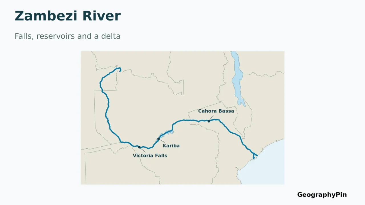
The Zambezi is not just the river at Victoria Falls. Its course links an upper-river loop through Angola, long border reaches, two major reservoirs and a delta on Mozambique’s coast. Following that sequence also clears up a frequent mistake: the eight countries in its drainage basin are not eight countries crossed by the main river.
The traditionally named Zambezi rises in northwestern Zambia and reaches the Indian Ocean through Mozambique. Between source and sea, it passes through Angola and follows several international border reaches, including the Zambia–Zimbabwe boundary at Victoria Falls. Lake Kariba and Cahora Bassa are major reservoirs on its course; the wider drainage basin is shared by eight countries.
How to use this article: Compare source and length definitions, separate river and basin countries, and check the reservoirs in downstream order.
1. Follow the Zambezi from source to sea
A southward loop before the long journey east
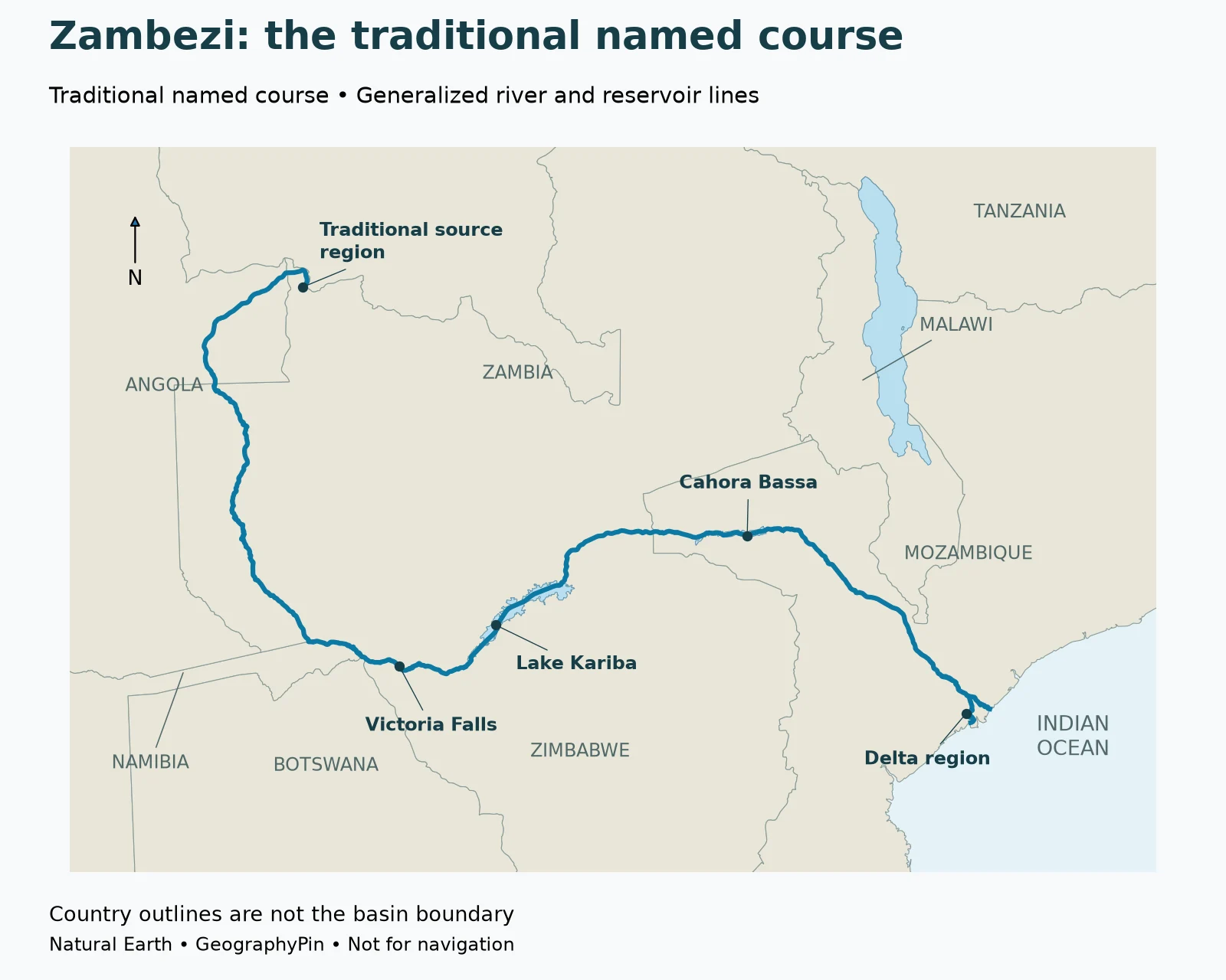
The Zambezi’s overall destination is the Indian Ocean, but its upper course does not head straight east. The traditionally named course begins in northwestern Zambia, turns through Angola, and returns to Zambia before running south toward the region where Zambia, Namibia, Botswana and Zimbabwe lie close together. Farther downstream, its broad course turns east through the Zambia–Zimbabwe borderlands and Mozambique.
The Zambezi River Authority gives a conventional approximate length of 1,680 miles (2,700 kilometers). That reference should not be treated as the only possible modern measurement. A river’s named source, its most distant hydrological headwater and the method used to trace its bends can produce different totals.
What newer research says about the source and length
A 2025 peer-reviewed study by Lourenco and colleagues reports about 1,913 miles (3,079 kilometers) from the traditional Zambian source to the ocean, and 2,126 miles (3,421 kilometers) along the longer route beginning at the Lungwebungu’s source in Angola. Its expedition-based calculations use centerline routes across Kariba and Cahora Bassa rather than the survey teams’ shoreline tracks.
The maps follow the traditionally named Zambezi course, not the longer Lungwebungu route. Different starting points and tracing methods explain why the newer research and conventional references give different lengths.
| Feature | Geographic position or role |
|---|---|
| Traditional named headwater region | Northwestern Zambia |
| Upper-course detour | Through Angola before returning to Zambia |
| Victoria Falls | On the Zambia–Zimbabwe border |
| Lake Kariba | Reservoir shared by Zambia and Zimbabwe |
| Cahora Bassa | Reservoir in Mozambique |
| Receiving ocean | Indian Ocean, at the Mozambique delta |
| Wider basin | Shared by eight countries, not identical to the main channel |
2. Which countries does the river touch, and which share its basin?
Main channel, border reach and catchment are different relationships
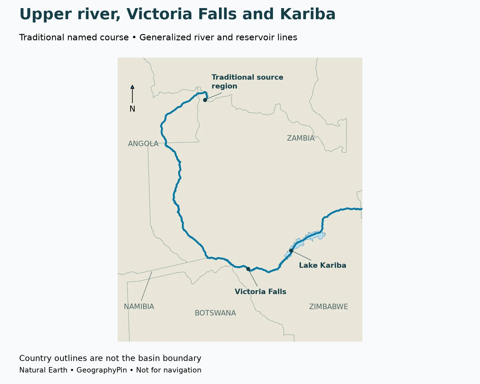
A river can be inside a country, along its border, or connected to it through tributaries. Those relationships should not be collapsed into a single phrase such as “flows through eight countries.” The Zambezi provides a particularly useful example because its main course and its wider basin have different geographical extents.
The upper river enters Angola and returns to Zambia. Farther south it follows part of the Zambia–Namibia boundary. Around Kazungula, the Kazungula Bridge links Zambia and Botswana across the Zambezi, as documented by the African Development Bank. Downstream, the river forms a long boundary between Zambia and Zimbabwe before entering Mozambique.
The Kazungula area needs care on a small-scale map. Several national boundaries come very close together there, but the broad regional graphic is not a legal survey of their exact junctions. It should not be used to infer a perfectly shared four-country point or to measure Botswana’s short river frontage. A bridge crossing between Zambia and Botswana is a more useful, well-documented geographic anchor than an oversimplified border slogan.
The eight-country basin includes places away from the main river
The drainage basin is shared by Angola, Botswana, Malawi, Mozambique, Namibia, Tanzania, Zambia and Zimbabwe. Water from different parts of that basin reaches the Zambezi through tributaries, lakes and connecting channels rather than by every country containing a long stretch of the main river.
Malawi and Tanzania illustrate the distinction. Lake Malawi, also called Lake Nyasa, drains south through the Shire River, which joins the lower Zambezi. Their connection to the wider drainage network does not put the Zambezi main channel through those countries. Similarly, a country can have a small share of a basin while still depending on its waters or cross-border connections.
For the basic terminology, see how a river’s channel differs from its drainage basin. Here, the map concentrates on the main course and two reservoirs; it does not shade an approximate basin outline or pretend that a national border follows a drainage divide.
3. Victoria Falls is one dramatic reach, not the whole river
A waterfall on an international boundary
Mosi-oa-Tunya / Victoria Falls lies on the Zambezi between Zambia and Zimbabwe. UNESCO recognizes the shared property for the falls and the geological landscape of basalt gorges. The waterfall is therefore both a geographic landmark on the river and part of a defined transboundary heritage site.
Looking upstream and downstream makes its setting clearer. The river approaches the falls from the west, then continues through a sequence of gorges toward the reaches farther downstream. Lake Kariba is beyond the falls along the river’s course; it is not the lake from which the waterfall directly emerges.
Do not turn a photograph into a year-round flow claim
The appearance of a waterfall changes with river conditions. A photograph taken during high water and one taken in a dry period can show very different amounts of exposed rock, spray and visible water. Neither is a complete annual description on its own.
4. Lake Kariba and Cahora Bassa: two reservoirs on the same river
Keep their order and locations separate
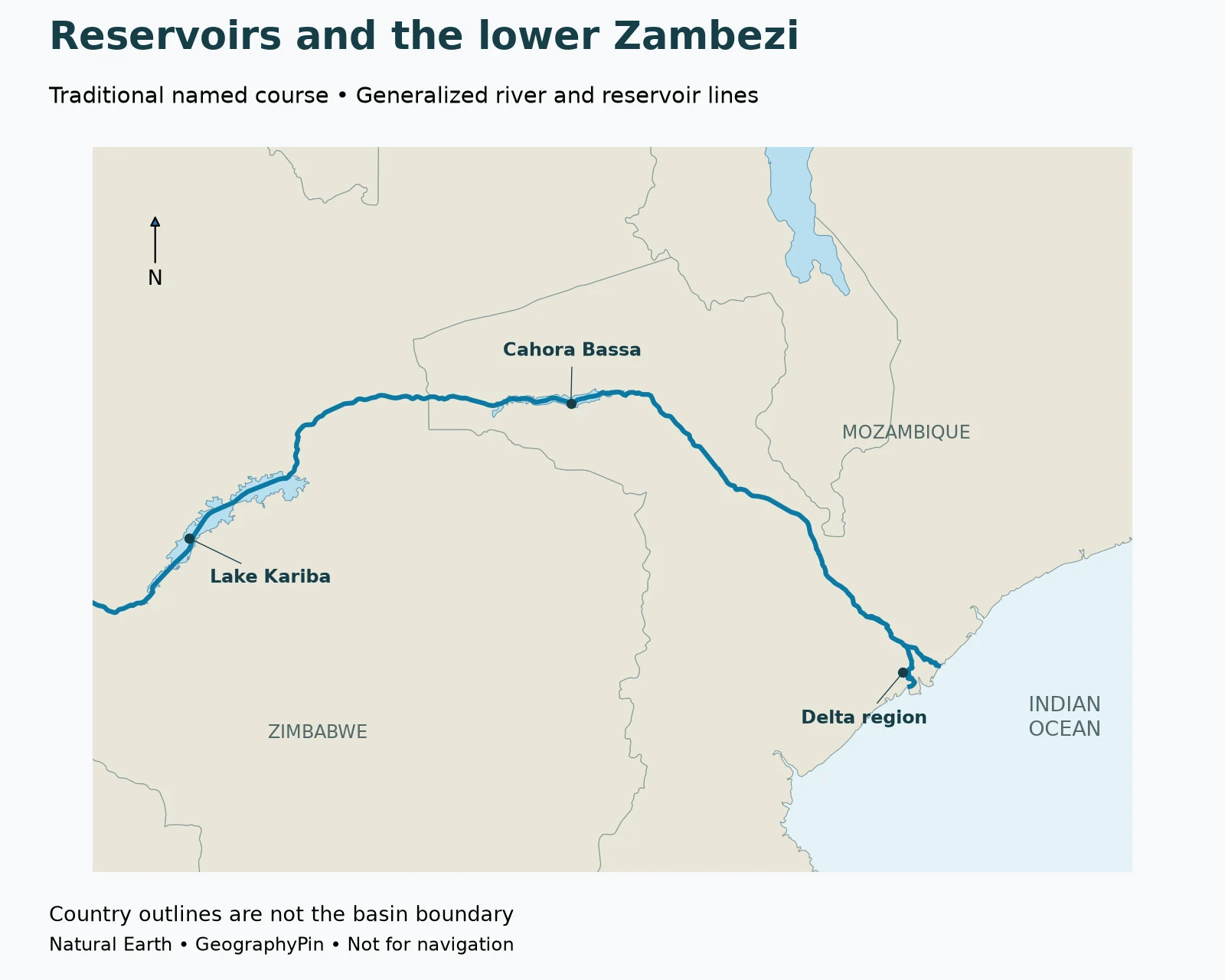
Following the river downstream from Victoria Falls, the first of the two large reservoirs highlighted here is Lake Kariba, shared by Zambia and Zimbabwe. Cahora Bassa is farther downstream in Mozambique. Both are impoundments associated with dams, not natural lakes whose origins can be inferred simply from their blue appearance on a map.
Kariba and Cahora Bassa should also not be treated as interchangeable names. They occupy different reaches and have different operators and local settings. The Zambezi River Authority publishes Kariba reservoir information; Hidroeléctrica de Cahora Bassa provides information about its Mozambican hydroelectric complex.
| Downstream landmark | Location | What the map shows |
|---|---|---|
| Victoria Falls | Zambia–Zimbabwe boundary | Waterfall-area locator |
| Lake Kariba | Zambia–Zimbabwe boundary | Generalized reservoir outline and centerline |
| Cahora Bassa | Mozambique | Generalized reservoir outline and centerline |
| Delta | Mozambique coast | Main-channel approach and selected mapped branches |
Table downloads (2)
- Key geographic features of the Zambezi River and basin (8 × 2)View tableDownload CSV
- Downstream Zambezi landmarks shown on the map (5 × 3)View tableDownload CSV
A reservoir outline is not today’s storage level
Reservoir outlines on these maps are static. They do not show current storage, electricity output or dam releases.
For dated measurements, consult the Zambezi River Authority’s Kariba reservoir data and Hidroeléctrica de Cahora Bassa. Keep the observation date, units and quantity being reported together. A reservoir’s total capacity, current stored volume, usable storage percentage and turbine discharge answer different questions.
5. The lower Zambezi and its Indian Ocean delta
A river mouth can be a branching landscape
After Cahora Bassa, the river continues through Mozambique toward the coast. The Shire joins the lower system, linking it with Lake Malawi’s drainage. Near the ocean, the Zambezi spreads into a low-lying delta rather than remaining a single narrow channel all the way to a simple point on the shoreline.
A delta is built and reshaped where a river delivers sediment to its receiving water. Channels, wetlands and the coast form a connected landscape, so “the mouth” can mean a particular outlet or the wider delta region. For this reason, the map labels a delta region rather than claiming one marker captures every channel mouth.
Read the whole route as a connected system
Upstream rainfall and tributary inflows feed the lower river, while reservoirs influence the timing of water moving downstream. The falls, reservoirs and delta are connected reaches, not isolated landmarks.
That connected geography is the useful takeaway. Victoria Falls is not the source; Lake Kariba is not the delta; and the eight-country basin is not a list of eight main-channel crossings. Once those distinctions are clear, the Zambezi becomes easier to place on an African map and easier to understand in reports about water, conservation or infrastructure.
Frequently Asked Questions
Does the Zambezi flow through eight countries?
Its drainage basin is shared by eight countries, but that is not a list of eight countries traversed by the main channel. Malawi and Tanzania connect to the wider system through the Lake Malawi–Shire drainage.
Is Victoria Falls the source of the Zambezi?
No. The traditionally named river rises much farther upstream in northwestern Zambia, passes through Angola and returns to Zambia before reaching the falls.
Is Lake Kariba upstream or downstream of Victoria Falls?
Lake Kariba is downstream of Victoria Falls. Cahora Bassa lies farther downstream again, in Mozambique.
Where does the Zambezi enter the ocean?
It reaches the Indian Ocean through a branching delta on the coast of Mozambique. The delta is a wider landscape, not just one outlet point.
How long is the Zambezi?
There is no single figure to use without its definition. ZRA gives about 1,680 miles (2,700 kilometers); the 2025 source-region study reports longer measured routes, including the Lungwebungu route from Angola. See the source-and-length discussion above.
What Did We Learn Today?
The traditionally named Zambezi connects northwestern Zambia with the Indian Ocean through a route that includes Angola, international border reaches, Victoria Falls, Lake Kariba, Cahora Bassa and Mozambique’s delta. Its eight-country basin is larger than its main channel. Reading the landmarks in downstream order, and separating static maps from current river measurements, gives a clearer picture than treating one waterfall or one reservoir as the whole river.
Sources & Data Notes
- Zambezi River Authority: geography: traditional headwater region, approximate 2,700-kilometer reference and eight-country basin.
- Lourenco et al. (2025), Hydrology and Earth System Sciences: source definitions and expedition-based length results.
- FAO: the Zambezi basin: source-to-mouth sequence, tributary connections. Historical flow and irrigation estimates are not presented as current observations here.
- African Development Bank: Kazungula Bridge project: Zambia–Botswana crossing over the Zambezi.
- UNESCO: Mosi-oa-Tunya / Victoria Falls: transboundary setting and geological significance.
- Zambezi River Authority: Kariba data and Hidroeléctrica de Cahora Bassa: reservoir/operator context. No live storage or generation value is quoted.
- Natural Earth: public-domain data: 1:10m river, lake and country geometry.
Map method: Original GeographyPin maps use Natural Earth river and lake centerlines, reservoir outlines and country outlines in a southern Africa Lambert conformal conic projection. The traditional-source-region marker follows the generalized river dataset’s upstream endpoint. The falls locator uses UNESCO’s published property reference; reservoir markers are representative points inside their mapped polygons, not dam locations. The delta marker identifies a broad area. Maps do not show a complete tributary network, every delta branch, legal border detail or a newly measured basin boundary.
Measurement limits: Published approximate river lengths are attributed separately, not combined into a new number. The map is not a length survey, a live water-level display or a navigation chart. Generalized reservoir outlines should not be interpreted as present storage conditions.