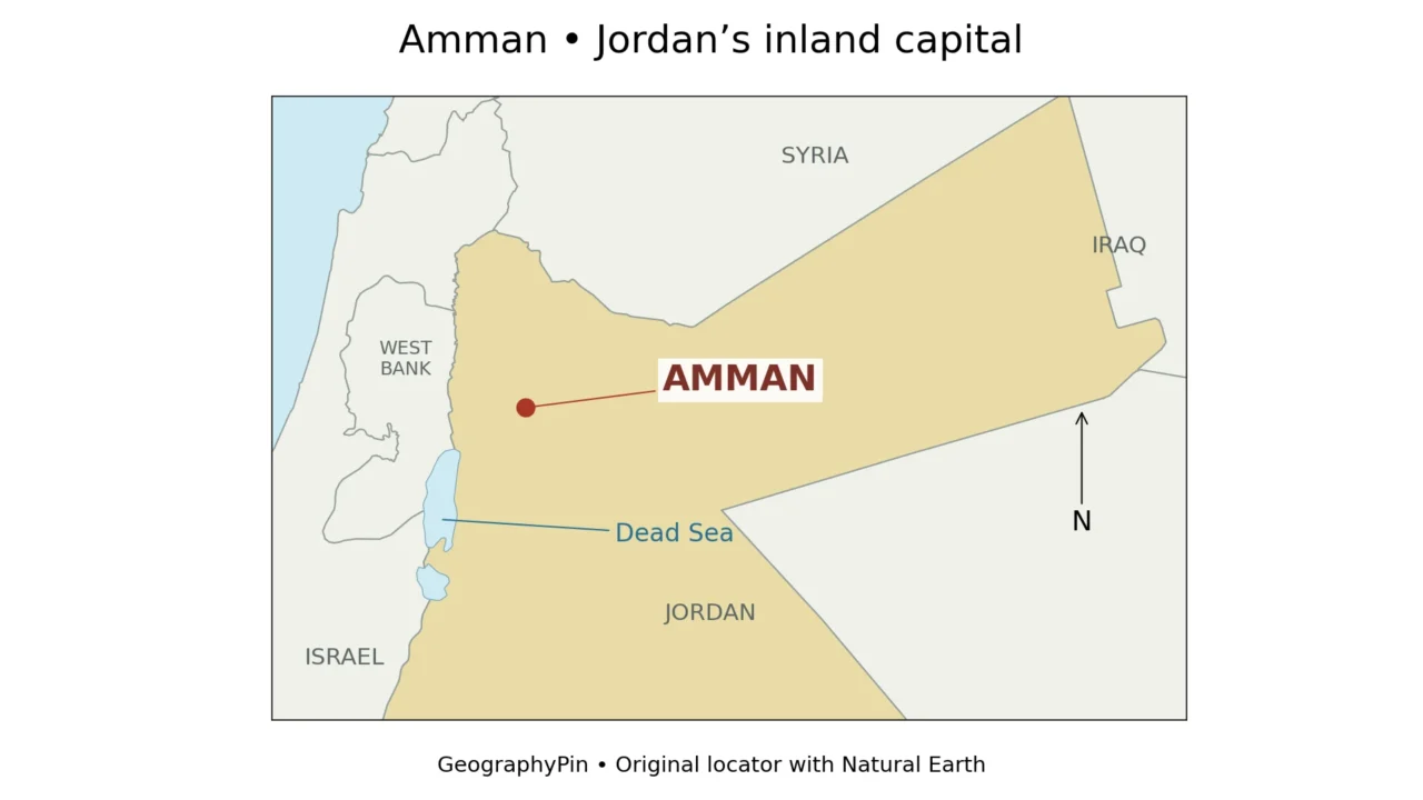
Amman is easier to understand as a hill-and-valley city than as a single dot beside a population number. Jordan’s capital occupies an inland upland setting, while the wider area bearing its name includes much more than the dense urban center. The distinction matters when reading its map, comparing its population or tracing where its water goes.
Amman is Jordan’s capital in the northwestern part of the country, east of the Jordan Valley and northeast of the Dead Sea. Its urban landscape spreads across hills and valleys. Greater Amman Municipality and Amman Governorate describe different administrative areas, while the Amman–Zarqa basin describes a drainage system rather than a city boundary.
Start here: Locate the capital on the map, compare the meanings of Amman, check the dated population figures, then explore why drainage and drinking-water supply are different.
1. Where is Amman?
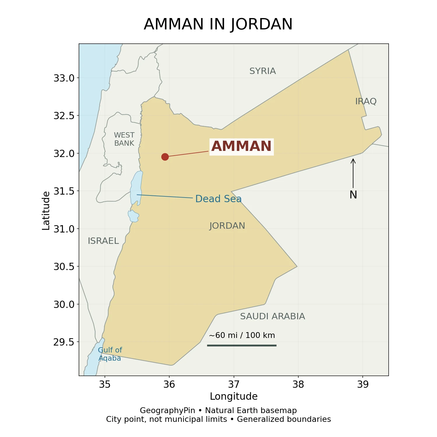
Amman lies in western Asia, in the Middle East. Within Jordan, it is in the northwest rather than near the country’s small Red Sea coast at Aqaba. The capital is inland: neither the Mediterranean Sea nor the Dead Sea forms its urban waterfront.
The Jordan Valley lies to the west, beyond the uplands. The Dead Sea is farther southwest. These relationships explain why a map showing Amman near the Dead Sea does not mean the city shares the lake’s below-sea-level setting. A locator shows horizontal position; it does not flatten the relief between two places.
The reference point used here is near 31.95° N, 35.93° E, rounded from Natural Earth’s populated-place data. It is useful for finding the city, not for locating every neighborhood or defining a metropolitan area.
2. A capital shaped by hills and valleys
Why hills and low ground matter
The Jordan Tourism Board describes Amman as a hilly city between the desert and the Jordan Valley. The central landscape is organized by slopes, ridgelines and lower corridors, not a single level plain. Streets and buildings occupy different elevations, so a city-wide altitude quoted without context hides much of the geography.
The Citadel provides a clear example of this relationship: its elevated position overlooks the older downtown area. The Roman Theatre is another, built into a hillside. These landmarks make the contrast between high ground and lower urban space visible without needing to treat every modern neighborhood as part of the same ancient footprint.
For movement around the city, the practical consequence is straightforward: two points close together on a flat map may have a considerable climb between them. A useful walking map therefore needs terrain and street connections, not just straight-line distance.
Dry conditions do not eliminate flash floods
UN-Habitat’s Amman Spatial Profile, published in 2022, identifies downtown as one of the city’s lower-lying areas and describes its exposure to flash flooding. It links the problem to steep terrain, extensive paved surfaces, development along wadis and drainage capacity.
A wadi is a valley or drainage channel that may carry water intermittently. Its route remains important even when no stream is visible. During intense rain, water can move rapidly down slopes and concentrate in low ground; a road or culvert does not erase that underlying drainage pattern. This is a city-geography explanation, not a forecast of flood conditions on any particular day.
3. City, municipality and governorate are not interchangeable
Three useful meanings of the same name
| Term | What it describes | What not to assume |
|---|---|---|
| Amman as an urban place | The built-up city and the neighborhoods people identify with it. | That its visible urban edge matches a single administrative line. |
| Greater Amman Municipality (GAM) | A municipal jurisdiction responsible for services and planning within its remit. | That every place in Amman Governorate is part of GAM. |
| Amman Governorate | A wider governorate-level administrative and statistical area. | That its entire population lives in the continuous urban core. |
UN-Habitat explicitly distinguishes governorate divisions, municipal planning areas and land-registration units. Their boundaries do not all align. This is not a technical footnote: a population figure, development plan and service-area map can each be accurate while describing different territory.
Boundaries can also change. The spatial profile records a major GAM expansion in 2007 and a reduction in 2011. Consequently, comparing two “Amman” figures from different years requires checking both the date and the area, not simply subtracting one number from the other.
For the general principle, see our explanation of a geographical area. Administrative areas answer questions about governance and statistics; functional urban areas answer questions about connections such as commuting. They need not have identical outlines.
4. How many people live in Amman?
Official estimates for the end of 2025
Jordan’s Department of Statistics publishes separate municipal and governorate tables. The following values are end-of-2025 population estimates, not a new census count and not a real-time population counter.
| Area in the official table | Estimated population | How to read it |
|---|---|---|
| Greater Amman Municipality, listed as “Amanet Amman Alkubrah” | 4,311,387 | The named municipal entry in the municipal estimates. |
| Amman Governorate | 5,004,600 | The governorate in the national governorate table. |
In round numbers, that is about 4.31 million for the municipal entry and 5.00 million for the governorate. Neither should be relabeled as an independently measured metropolitan population. The governorate table also distinguishes urban and rural populations, reinforcing that a governorate is not simply a synonym for one city.
There is an additional source detail worth retaining. The municipal publication’s combined Amman-area subtotal differs slightly from the governorate total. Its footnote explains a difference involving the inclusion of Abu Saiah locality from Zarqa Governorate. The table above therefore uses each explicitly labeled entry rather than silently substituting one subtotal for another.
5. Amman’s water geography: the Zarqa basin and beyond
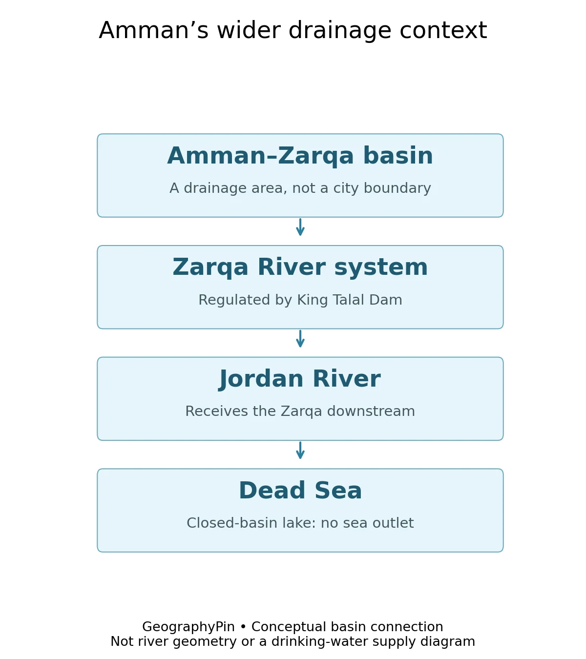
Amman belongs to the wider Amman–Zarqa drainage setting. A 2011 study prepared for UNDP Jordan by Jordanian university research centers describes drainage developing through the Amman–Zarqa depression and the Zarqa River ultimately joining the Jordan River. King Talal Dam regulates part of this river system.
This does not put Amman directly on the Jordan River. The Jordan occupies a different geographic corridor farther west. The connection is through a drainage network, with tributaries and managed water flows between the urban uplands and the valley.
Drainage is not the same as drinking-water supply
A drainage basin describes where surface water is directed by the landscape. A city’s water-supply system describes how water is collected, treated and transported to users. Those are different networks.
UN-Habitat’s 2022 profile describes Amman’s supply as drawing on multiple sources, including the Disi aquifer project and water conveyed through the King Abdullah Canal and treated at Zai. We should not infer from the basin diagram that household taps are supplied simply by the nearby river, or that all supplied water originated within municipal boundaries.
The broader downstream context is the Jordan River–Dead Sea system. The Dead Sea is a closed-basin lake rather than an outlet to the Mediterranean. The diagram shows that geographic relationship, not a promise that every drop of runoff from Amman reaches the lake.
Frequently Asked Questions
Is Amman on the Dead Sea?
No. Amman is inland and northeast of the Dead Sea, in an upland setting. It is not a lakeside city, and its streets do not share the Dead Sea’s below-sea-level elevation.
What is the population of Amman?
The official end-of-2025 estimates list 4,311,387 for Greater Amman Municipality and 5,004,600 for Amman Governorate. Specify the area and date; these are not interchangeable metropolitan counts.
Is Amman on the Jordan River?
No. Amman is connected to the wider Amman–Zarqa drainage system. The Zarqa joins the Jordan River farther downstream; the Jordan does not run through central Amman.
Why can Amman flood if the region is dry?
Intense rainfall can concentrate quickly in valleys and low ground. Steep slopes, paving and constrained drainage can increase runoff and overwhelm channels or culverts, especially in lower urban areas.
What Did We Learn Today?
Amman is an inland, hilly capital in northwestern Jordan, not a city on the Dead Sea or Jordan River. Its physical drainage setting belongs to the Amman–Zarqa system, while its municipal and governorate boundaries serve different purposes. Reading a location, population figure or water diagram correctly means checking what area and connection it actually represents.
Sources & Data Notes
Population values are official estimates for the end of 2025. The municipal and governorate entries retain their separate definitions; no metropolitan total or current daily estimate is calculated. Historical boundary changes and infrastructure descriptions are attributed to the 2022 spatial profile, not presented as new administrative announcements.
The two original locator graphics use Natural Earth country, lake and populated-place data. The reference point is rounded to 31.95° N, 35.93° E. Generalized boundaries and lake outlines are for orientation, not a legal boundary survey or a current shoreline measurement. The drainage illustration is a conceptual relationship diagram. The 2011 basin report supports the basic drainage connection; its historical population, discharge and water-demand statistics are not used as current figures.
- Jordan Department of Statistics: end-of-2025 municipal population estimates
- Jordan Department of Statistics: end-of-2025 governorate estimates, Table 2.2
- UN-Habitat: Amman Spatial Profile, 2022
- Jordan Tourism Board: Amman
- Jordanian university research centers for UNDP Jordan: Zarqa River Basin assessment, 2011
- Natural Earth: public-domain map data