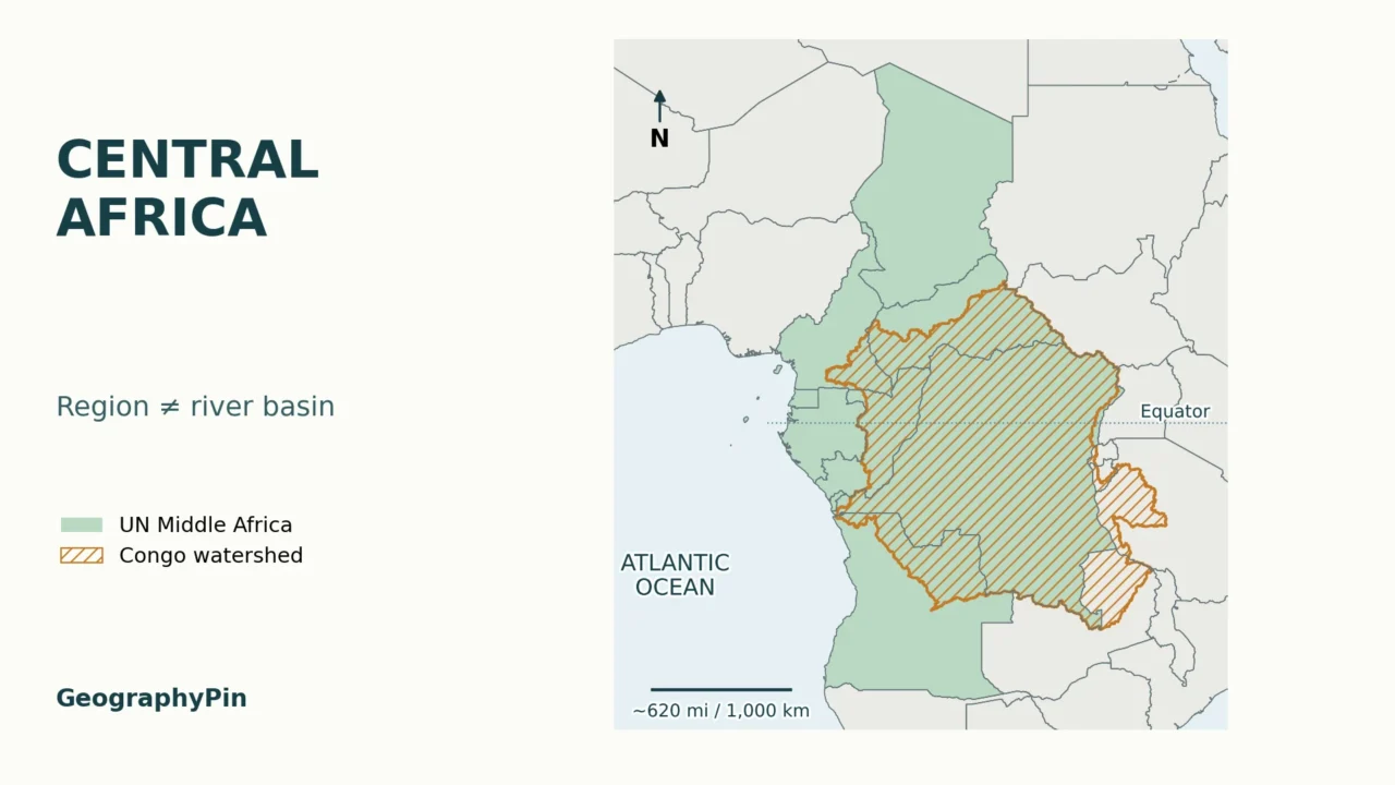
A country map and a Congo Basin map can both be labeled “Central Africa” while showing different places. The distinction matters: one groups whole countries; the other follows the land draining into a river system. The maps below separate those two meanings rather than treating the region, its forests and its watershed as interchangeable.
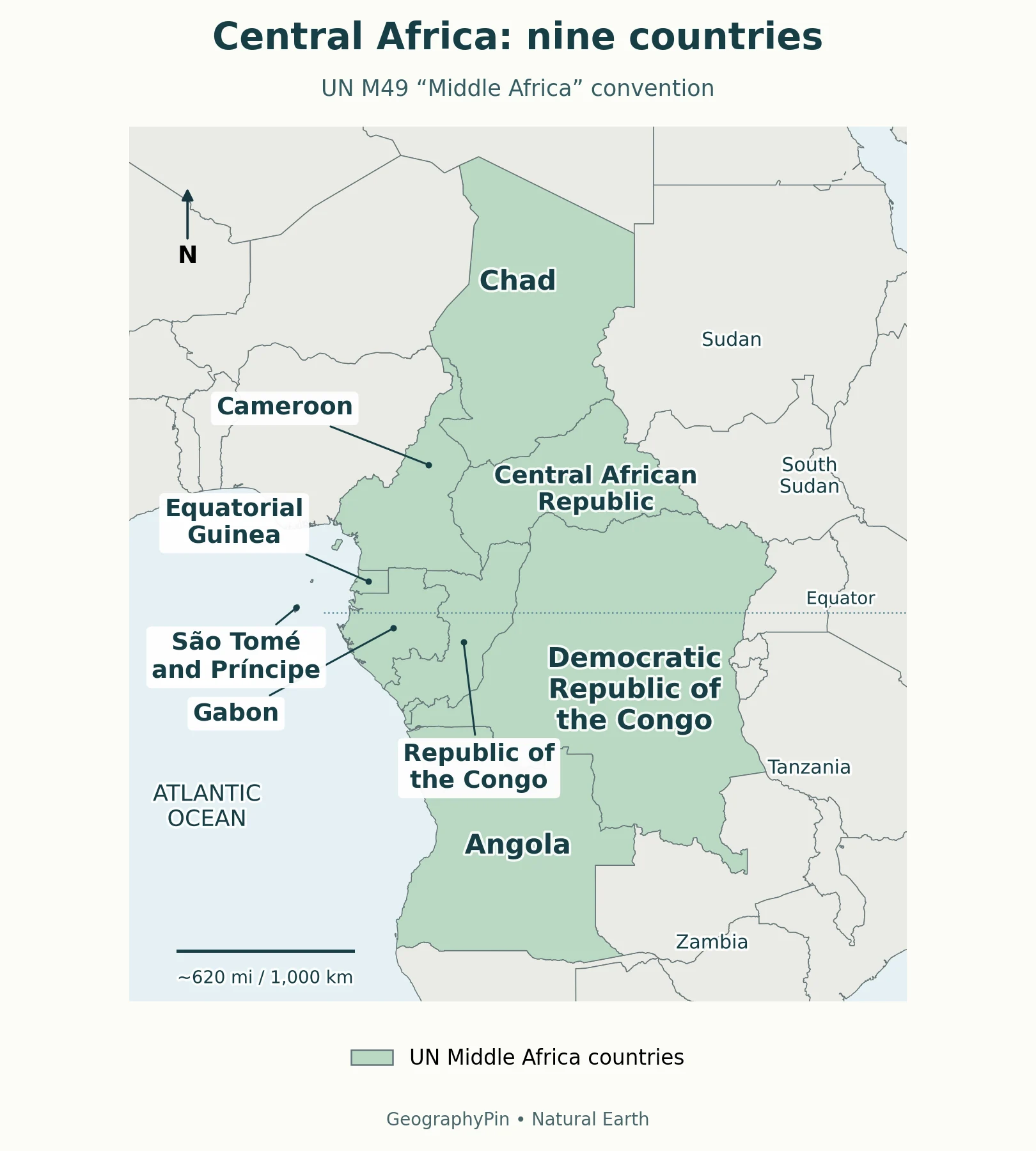
This Central Africa countries map follows the United Nations’ nine-country Middle Africa grouping: Angola, Cameroon, Central African Republic, Chad, Democratic Republic of the Congo, Equatorial Guinea, Gabon, Republic of the Congo, and São Tomé and Príncipe. “Central Africa” also has broader uses; the Congo drainage basin is a separate physical boundary, not this country list.
Find your starting point: Check the country convention, distinguish the two Congos, or compare country borders with the watershed.
1. Read the Central Africa Countries Map
Which definition does this map use?
The UN Statistics Division’s M49 classification calls this subregion Middle Africa. The map uses that explicit convention for Central Africa. M49 is a statistical grouping, not a statement that every cultural, historical or institutional definition must have the same boundary.

Start with the Atlantic coast on the left. Angola forms the southern mainland end of the selected group, Chad reaches farthest north, and the Democratic Republic of the Congo extends toward the Great Lakes on the eastern side. São Tomé and Príncipe lies offshore in the Gulf of Guinea. It belongs in the list even though its islands are easy to miss on a continent-wide map.
Country colors identify membership in this grouping. They do not represent rainfall, forest cover, political alliances or the direction in which rivers flow. A country left outside the highlight is not “less African”; it is assigned to a different subregion under this particular classification.
For the continent-wide setting, use the Africa country atlas and regional sheets. This closer view adds the distinction between the regional country list and the Congo watershed, rather than replacing that broader atlas.
2. The Nine Countries in the Map
Each row below represents one sovereign state. Islands and detached pieces of national territory do not create extra countries in the count. The table is a map-reading aid, not a ranking by area, population or importance.
| Country | Where to look | Useful distinction |
|---|---|---|
| Angola | Southern end of the mainland group | Cabinda is a separate part of Angola north of its main territory. |
| Cameroon | Western side, between Nigeria and the Central African Republic | Its long north–south shape reaches well beyond the equatorial forest belt. |
| Central African Republic | Inland, south of Chad and north of DR Congo | A single sovereign country, not another name for the whole region. |
| Chad | Northern end of the selected group | Membership here does not place it inside the Congo drainage basin. |
| Democratic Republic of the Congo | Large country in the central and eastern part of the map | Also called DR Congo or DRC; distinct from the Republic of the Congo. |
| Equatorial Guinea | Gulf of Guinea mainland and islands | The mainland and offshore islands are parts of one country. |
| Gabon | Atlantic coast, south of Equatorial Guinea | Its inclusion in Middle Africa does not make its entire territory Congo-draining land. |
| Republic of the Congo | West of DR Congo, with an Atlantic coast | Often called Congo-Brazzaville; M49 shortens its name to Congo. |
| São Tomé and Príncipe | Gulf of Guinea, off the mainland coast | An island state; not part of the mainland Congo watershed. |
Cabinda is especially useful for understanding the coastline: Angola does not form one uninterrupted mainland shape. Likewise, Equatorial Guinea cannot be represented accurately by highlighting only its continental portion. These small pieces matter more than their size suggests when identifying countries on a regional map.
Capitals answer a different question from regional membership. For that lookup, use the African countries and capitals reference; the labels here identify countries rather than capital-city locations.
3. Separate the Countries With Similar Names
DR Congo and the Republic of the Congo
The Democratic Republic of the Congo and the Republic of the Congo are neighboring countries, not interchangeable names. Kinshasa is the capital of the former; Brazzaville is the capital of the latter. “Congo-Kinshasa” and “Congo-Brazzaville” are useful identifying shorthands when a source uses the word Congo without enough context.
On the map, DR Congo is the much larger country stretching eastward. The Republic of the Congo sits mainly to its west and northwest. The Congo River is a watercourse shared across a wider river system; it is not a third country. For the separate historical question behind the names, see why there are two Congos.
Central African Republic versus Central Africa
The Central African Republic, often abbreviated CAR, is one landlocked state within the nine-country group. “Central Africa” is the regional expression. A report about events in the Central African Republic therefore should not be read as a report about every Central African country.
A useful reading habit is to identify the type of name before interpreting it: Republic identifies a state, River identifies a channel, and Basin identifies a drainage area or, in some contexts, a broader forest region. Similar wording does not make their boundaries the same.
4. Compare the Region With the Congo Drainage Basin
A watershed follows drainage, not a country list
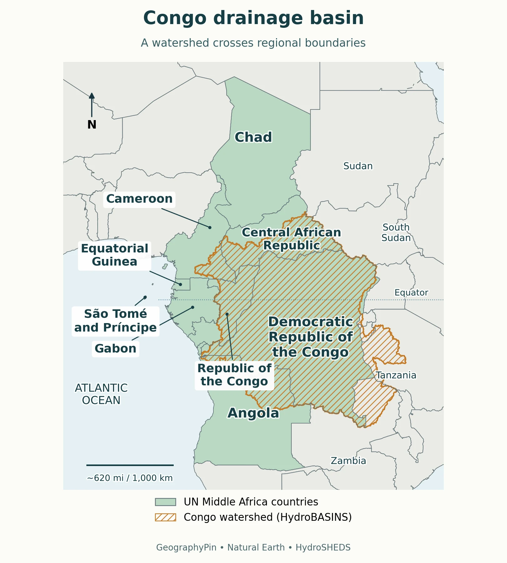
A drainage basin is the area contributing surface drainage to a shared outlet. The USGS watershed explanation distinguishes that collecting area from the streams within it. For the Congo, the complete drainage system ultimately reaches the Atlantic Ocean. Its dividing line crosses national territory instead of following a nine-country membership rule.

The basin comparison uses a separately delineated hydrological boundary over country outlines. It is not a freehand patch of forest, a buffer around the Congo River, or the combined borders of countries mentioned in a basin report. The distinction is visible where the basin cuts across a country and where it extends beyond the highlighted Middle Africa group.
DR Congo occupies much of the basin’s central area, but the watershed is neither identical to DR Congo nor confined to the two Congos. Parts of the surrounding countries contribute to it. Conversely, Chad and the offshore islands of São Tomé and Príncipe belong to the regional country group without lying inside the Congo watershed.
Follow the network toward the Atlantic
CICOS, the International Commission of the Congo–Oubangui–Sangha Basin, describes the Congo’s upper course as the Lualaba and identifies the Ubangi, Sangha and Kasai among the river system’s major tributaries. Those branches explain why the collecting area spreads far beyond the main river line. Water can join the system through a tributary long before reaching the channel labeled Congo.
The lower river reaches the Atlantic through a much narrower coastal corridor than the basin’s broad inland area. A regional map can show an enormous inland catchment and a comparatively short stretch of coastline without contradiction: the whole collecting area funnels toward an outlet. GeographyPin’s river-parts and drainage-basin explainer gives the underlying vocabulary.
The mapped line is appropriate for regional comparison, not for deciding which side of a local ridge, property boundary or minor stream falls into the basin. Dataset resolution and drainage modeling affect fine details. No basin-country total is inferred from tiny intersections between generalized national and hydrological outlines.
5. Understand Forest and Organization Maps
Why a forest report may name six countries
“Congo Basin” also appears in forest conservation and climate-finance writing. For example, the World Bank’s 2026 forest-sector roadmap announcement discusses Cameroon, Central African Republic, DR Congo, Equatorial Guinea, Gabon and Republic of the Congo. That six-country scope describes the countries participating in the forest-focused work; it is not a replacement for a hydrological basin outline.
A map of forest extent would need vegetation data and an explicit forest definition. The basin outline here does not claim that every point inside it is forested, or that all forests associated with the Congo Basin lie within that drainage line. A national forest program can cover places draining to other rivers.
Organizations use membership, not the map’s inclusion rule
Regional organizations answer another question: which states participate in a particular institution? Their lists should not be substituted for either the M49 country group or the watershed. CICOS, for example, describes its mandate in terms of inland navigation and integrated water-resource management, with a jurisdiction tied to basin territory in member states.
The Economic Community of Central African States, usually abbreviated ECCAS or CEEAC, is also an institutional grouping. A map labeled with its membership needs its own dated membership source. The country map above is deliberately not an ECCAS membership map, so political decisions about an organization do not silently alter its geographic convention.
When comparing two maps, read the legend before comparing the count. Ask whether the units are whole countries, a drainage area, forest cover or organization members. Two maps can overlap heavily and still be answering different questions. The safest caption names both the feature and the rule used to draw it.
Frequently Asked Questions
Does every Central African country cross the Equator?
No. The region straddles the Equator, but individual countries can lie entirely north or south of it. Regional membership is not an Equator-crossing test; use the latitude line on a map to answer that separate question.
Should Rwanda and Burundi be added to this country map?
Not under the stated M49 Middle Africa convention: M49 places both in Eastern Africa. They may appear in broader discussions of Central Africa, but adding them here would change the map’s declared rule.
What Did We Learn Today?
Central Africa becomes easier to read when each boundary has a clear job. The nine-country map uses a statistical convention; the two Congos and the Central African Republic are separate states; the Congo drainage basin follows connected water flow. Forest projects and regional organizations use different scopes again. Matching the map to the question prevents a country list from being mistaken for a watershed.
Sources & Data Notes
Country membership follows UN M49 Middle Africa. Country outlines come from Natural Earth; the Congo drainage outline is a separate HydroBASINS delineation. The basin overlay shows drainage, not forest cover, institutional membership or a national boundary. Generalized mapping is intended for regional orientation, not local boundary decisions. Forest-sector examples have their own stated program scope.
- UN Statistics Division: M49 geographical regions
- USGS: Watersheds and Drainage Basins
- CICOS: Le Fleuve Congo
- CICOS: mandate and jurisdiction
- World Bank: Congo Basin forest-sector roadmaps, February 2026
- Natural Earth: public-domain map-data terms
- HydroBASINS: basin delineation and data documentation
Hydrological layer: HydroBASINS Africa standard level 3, version 1c, Congo basin record 1030020040. Country geometry: Natural Earth 1:10 million. Source-derived outlines are generalized; the basin is not traced from country borders. Method reference: Lehner and Grill (2013).
This product GeographyPin Central Africa and Congo Basin maps incorporates data from the HydroSHEDS version 1 database which is © World Wildlife Fund, Inc. (2006–2022) and has been used herein under license. WWF has not evaluated the data as altered and incorporated within GeographyPin Central Africa and Congo Basin maps, and therefore gives no warranty regarding its accuracy, completeness, currency or suitability for any particular purpose. Portions of the HydroSHEDS v1 database incorporate data which are the intellectual property rights of © USGS (2006–2008), NASA (2000–2005), ESRI (1992–1998), CIAT (2004–2006), UNEP-WCMC (1993), WWF (2004), Commonwealth of Australia (2007), and Her Royal Majesty and the British Crown and are used under license. The HydroSHEDS v1 database and more information are available at HydroSHEDS.