There are two Congos because separate territories around the Congo River followed French and Belgian colonial paths, and each inherited the older Congo/Kongo regional name. They did not begin as one modern country and then split. Both became independent in 1960: the Democratic Republic of the Congo from Belgium and the Republic of the Congo from France.
How to use this article: Start with the quick comparison, follow the shared name, scan the parallel timelines, or see why the two capitals face each other.
Congo vs. DR Congo: The Quick Difference
The two countries at a glance
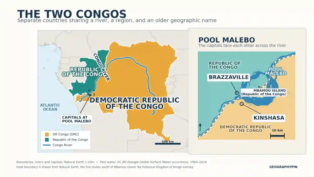
The Democratic Republic of the Congo is the much larger country and has Kinshasa as its capital. The Republic of the Congo lies to its west and northwest and has Brazzaville as its capital.
| Detail | Democratic Republic of the Congo | Republic of the Congo |
|---|---|---|
| Official name | Democratic Republic of the Congo | Republic of the Congo |
| Common shorthand | DRC, DR Congo, Congo-Kinshasa | Republic of the Congo, Congo-Brazzaville |
| Capital | Kinshasa | Brazzaville |
| Former colonial ruler | Belgium; preceded by the Congo Free State under King Leopold II | France; formerly Middle Congo within French Equatorial Africa |
| Independence | June 30, 1960, from Belgium | August 15, 1960, from France |
| Surface area | 905,568 sq mi (2,345,410 km²) | 132,047 sq mi (342,000 km²) |
| Currency | Congolese franc (CDF) | Central African CFA franc (XAF) |
| ISO country code | CD (alpha-2); COD (alpha-3) | CG (alpha-2); COG (alpha-3) |
Both appear as separate sovereign states in GeographyPin’s list of the 54 countries in Africa and their capitals. The similar names do not indicate a federal relationship or a shared government.
Why Both Countries Are Called Congo
From Kongo peoples to river and country names
The name is older than either republic. It is connected to the Kongo peoples and the historical Kingdom of Kongo, which developed in the lower Congo region centuries before European colonial borders.
European usage rendered the name as Congo and applied it to the great river and the surrounding region. That regional name then appeared in colonial names on both sides of the river. When those separately governed territories became states, each retained Congo in its national name.
Kongo is commonly used when referring to the people, language, and historical kingdom, while Congo is standard in the English names of the river and modern countries. The ultimate literal origin of the word Kongo is uncertain, so confident translations such as “hunter” or “gathering place” should not be treated as settled fact.
The Kingdom of Kongo was not either modern Congo
The Royal Museum for Central Africa describes the kingdom at its height as extending across parts of present-day Angola, the Democratic Republic of the Congo, and the Republic of the Congo. Its reach changed over time and was not identical to the borders of either country today.
This distinction matters: the shared name has a deep regional history, but neither modern republic is simply the old Kingdom of Kongo under a new flag.
Two Colonies, Not One Country Split in Two
The two colonial tracks
The French track: France administered territory north and west of the lower Congo River as French Congo and later Middle Congo. Middle Congo became a constituent territory of French Equatorial Africa, a federation administered separately from the territory across the river.
The Leopold and Belgian track: The Congo Free State was established in 1885 under the personal sovereignty of Belgium’s King Leopold II. It was not yet a Belgian colony. Belgium annexed it in 1908, after which it became the Belgian Congo.
These were already separate territorial administrations before decolonization. Their boundaries, capitals, officials, and colonial institutions developed under different European authorities. Independence converted those two colonial frameworks into two sovereign states; it did not divide one independent Congo into eastern and western halves.
The former Belgian Congo became independent on June 30, 1960. The Republic of the Congo became independent from France on August 15, 1960. The U.S. Office of the Historian records the two events separately, reflecting their different colonial successions.
How the Two Congos’ Names Changed
The confusing part is that both states used Republic of the Congo in 1960. Each was a republic formed from a territory already known by a Congo name, so the same straightforward state name arose independently. International documents and news reports distinguished them by adding their capitals: Congo-Léopoldville for the former Belgian territory and Congo-Brazzaville for the former French territory. Those capital labels were practical disambiguators rather than evidence that the countries had once been united.
Parallel naming timelines
Republic of the Congo path
French Congo / Middle Congo → Republic of the Congo → People’s Republic of the Congo → Republic of the Congo
- Colonial period: French Congo, then Middle Congo within French Equatorial Africa.
- 1958–1969: Republic of the Congo; fully independent from August 15, 1960.
- From December 31, 1969: People’s Republic of the Congo.
- 1991: Republic of the Congo restored during the democratic transition; a new constitution followed in 1992.
Democratic Republic of the Congo path
Congo Free State → Belgian Congo → Congo-Léopoldville → Democratic Republic of the Congo → Zaire → Democratic Republic of the Congo
- 1885–1908: Congo Free State.
- 1908–1960: Belgian Congo.
- June 30, 1960–July 31, 1964: Republic of the Congo, commonly distinguished as Congo-Léopoldville.
- August 1, 1964–October 26, 1971: Democratic Republic of the Congo.
- October 27, 1971–May 16, 1997: Republic of Zaire.
- From May 17, 1997: Democratic Republic of the Congo again.
The United Nations authority record fixes the former Belgian territory’s major modern changes at August 1, 1964, October 27, 1971, and May 17, 1997. Léopoldville was renamed Kinshasa in 1966, so Congo-Kinshasa replaced Congo-Léopoldville as the useful capital-based shorthand.
Kinshasa and Brazzaville Face Each Other Across the River
Two capitals at Pool Malebo
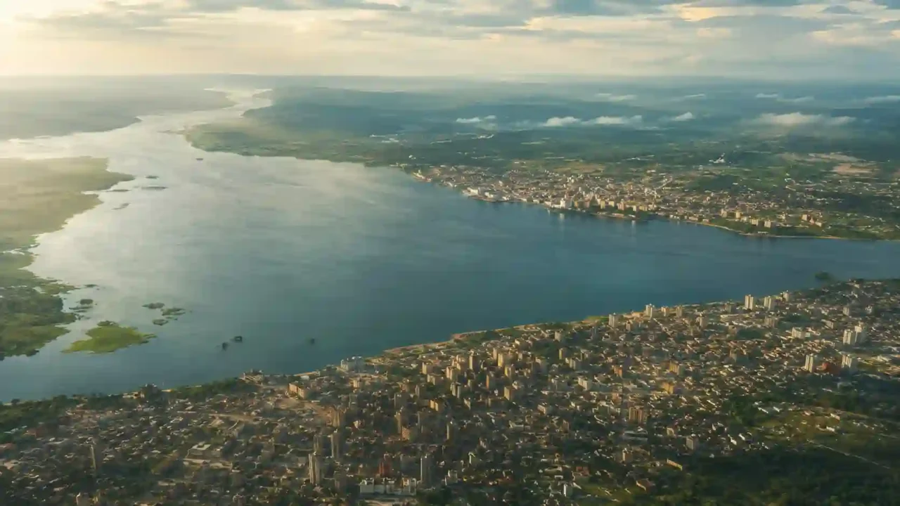
Kinshasa stands on the southern bank of the Congo River, while Brazzaville stands on the northern bank. They face each other near the downstream end of Pool Malebo, a broad, lake-like widening of the river. A NASA image from the International Space Station makes the two-city geography especially clear.
This unusual arrangement helps explain why capital-based labels work so well: Kinshasa immediately identifies the DRC, and Brazzaville identifies the Republic of the Congo. GeographyPin’s list of world capital cities treats them as two separate country-capital pairs.
The Congo River forms a long central part of the international frontier, but not the entire boundary between the countries. Farther north the border follows the Ubangi River, while its southern portion also includes other river and overland sections. A close map of Pool Malebo must also account for Mbamou Island rather than drawing a simplistic straight line through the water.
What to Call Each Congo Today
On first reference, the full official names are the safest choice. After that, these forms keep the countries clear:
- DRC, DR Congo, or Congo-Kinshasa means the Democratic Republic of the Congo, the larger former Belgian territory.
- Republic of the Congo or Congo-Brazzaville means the smaller former French territory.
- Zaire refers historically to the present-day DRC during the 1971–1997 period.
- Congo-Léopoldville is the historical disambiguating label for the present-day DRC before Léopoldville became Kinshasa.
Using Congo alone is acceptable only when context makes the country unmistakable. A map, table, headline, or dataset that includes both should always use distinct names or codes.
Frequently Asked Questions
Are the two Congos the same country?
No. The Democratic Republic of the Congo and the Republic of the Congo are separate sovereign states with different capitals, governments, currencies, and country codes.
Which Congo is larger?
The Democratic Republic of the Congo is larger. Using UNData’s surface-area figures, it is about 6.9 times the size of the Republic of the Congo.
Which capital belongs to which country?
Kinshasa is the capital of the Democratic Republic of the Congo. Brazzaville is the capital of the Republic of the Congo.
Was one country divided into two?
No. The two states emerged from separately administered Belgian- and French-controlled territories; no single independent modern Congo was split to create them.
Why is French official in both Congos?
French was used for administration in both colonial systems, although one territory was ruled by France and the other by Belgium. Each post-independence state retained French as an official language alongside important national and local languages.
Which Congo is usually meant in international news?
Headlines using Congo alone often mean the DRC, especially when they mention Kinshasa or eastern Congo, but the word is inherently ambiguous. Check the capital, neighboring places, or country code before assuming.
What Did We Learn Today?
The two Congos share an older regional name connected to the Kongo peoples, kingdom, and river, but their modern state histories followed separate colonial tracks. The former Belgian territory became today’s DRC, while the former French territory became the Republic of the Congo; their capitals, Kinshasa and Brazzaville, face each other across the Congo River.
Sources & Data Notes
Surface areas are UNData’s 2023 surface-area values, not land-area-only figures; square-mile values are conversions rounded to the nearest square mile. The Republic of the Congo timeline uses December 31, 1969, for the People’s Republic designation and 1991 for restoration of the Republic name during the transition. The proposed regional map should use current Natural Earth layers, while the close Pool Malebo inset requires finer validated water and boundary data.
- U.S. Office of the Historian: Democratic Republic of the Congo
- U.S. Office of the Historian: Republic of the Congo
- U.S. Office of the Historian: The Congo Free State
- United Nations Repertory of Practice, Supplement No. 3, Article 4
- United Nations Treaty Collection: Historical Information
- Embassy of the Republic of the Congo: History and the Republic of the Congo Secretariat-General’s 1991 special official journal
- Royal Museum for Central Africa: The Kongo Kingdom and W. Holman Bentley’s Dictionary and Grammar of the Kongo Language
- United Nations Data country profiles: Democratic Republic of the Congo and Congo; ISO Online Browsing Platform for country codes
- NASA Earth Observatory: Kinshasa and Brazzaville
- Map data and boundary checks: Natural Earth Admin 0 Countries, Rivers and Lake Centerlines, and Populated Places; International Boundary Study No. 127; and the EC Joint Research Centre Global Surface Water dataset