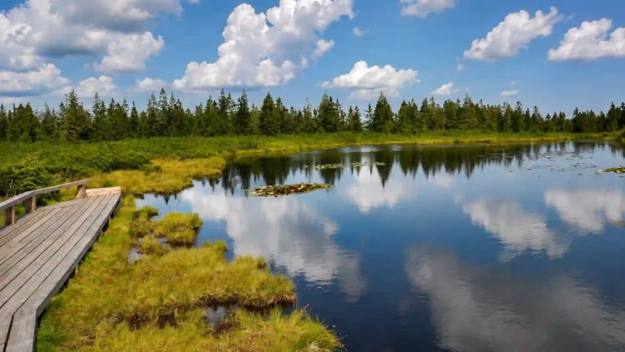
Ribniško jezero is best understood as a rain-fed peat-bog complex in Slovenia’s Pohorje massif, containing a main shallow pool and several smaller pools. The wider system is an active raised bog, while official Natura 2000 material also recognizes natural dystrophic standing water at the site. The water is real; the mistake is treating the entire peatland as a conventional deep, mineral-basin lake.
How to use this article: Go directly to what “raised” means, what the measurements describe, why pool counts differ, or how to reach the site responsibly.
Where Ribniško jezero is
Ribniško jezero lies in the Pohorje massif of northeastern Slovenia, below Jezerski vrh and east of Ribniški vrh. Ribniška koča, a mountain hut and the usual starting point for the short approach, is nearby.
The names describe overlapping but not identical things. Ribniško jezero is the established place-name and is commonly used for the principal pool or the visitor site. Ribniško barje means Ribniško bog and is the name used in Slovenian Natura 2000 habitat material for the wider peat-forming system.
| Fact | Best-supported description |
|---|---|
| Setting | Pohorje massif, northeastern Slovenia, below Jezerski vrh |
| Habitat | Active raised bog, type 7110, with natural dystrophic standing water, type 3160 |
| Site elevation | Approximately 4,890 feet (1,490 meters) |
| Principal pool | Approximately 276 feet (84 meters) long; this is not the size of the entire bog |
| Pool depth | Roughly 3 feet (1 meter) of water to peat; this is not the peat deposit’s total thickness |
| Water source | Principally precipitation rather than a stream or mineral-rich groundwater |
| Smaller pools | Several; habitat and visitor sources use different feature categories and counts |
| Short approach | About 0.8 mile (1.3 kilometers) and roughly 25–30 minutes from Ribniška koča |
Lake, wetland, or raised bog?
The classification depends on what is being described
A lake is primarily a standing body of open water occupying a basin. A wetland is defined by persistent or recurring saturation, wet soils and biological communities adapted to those conditions. A bog is a peat-forming wetland, and a raised bog is a particular rain-fed type whose accumulated peat separates much of its surface from mineral-rich groundwater.
Depth alone does not settle the question: a lake can be shallow. The important point is that open water is only one component at Ribniško jezero. As the broader definition of a lake and its boundary with wetlands explains, real landscapes do not always fit a simple water-versus-land division.
Why “not a real lake” is too blunt
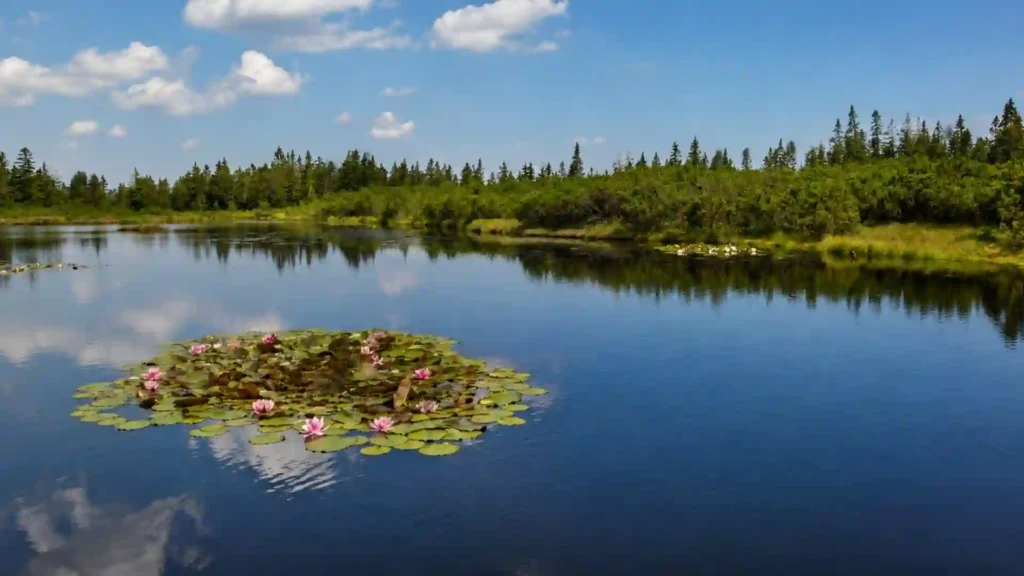
The phrase is trying to correct the place-name, but it can create a new error. Ribniško jezero contains genuine standing water: one principal pool and several smaller openings. What is not conventional is the larger landform. The pools belong to a living peat-bog complex, and their bottoms continue into peat rather than defining a separate deep lake basin.
The clearest formulation is therefore: Ribniško jezero is a lake-named visitor site within Ribniško barje, an active raised-bog complex whose open water is also recognized as natural dystrophic standing-water habitat.
How rain, sphagnum, and peat built the bog
Ombrotrophic means rain-fed
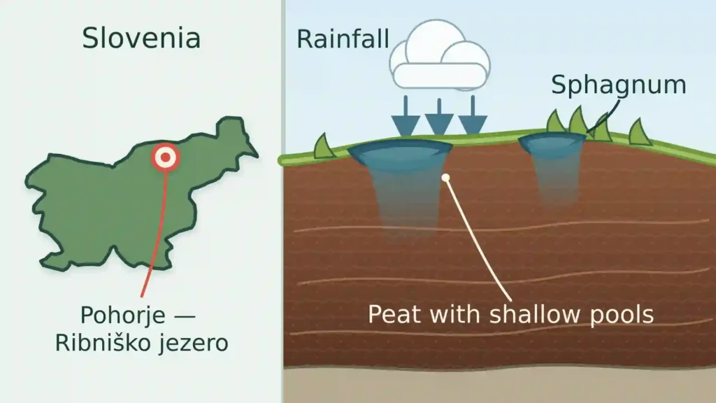
Raised bogs are ombrotrophic: their surface receives its water and small supply of nutrients principally from precipitation. In plain English, the bog depends on rain and snow rather than regular inflow from a stream or nutrient-rich groundwater.
That separation helps create acidic, nutrient-poor conditions. Those conditions exclude many ordinary plants but suit specialized bog vegetation, especially peat-forming sphagnum mosses.
How sphagnum becomes peat
Sphagnum holds large amounts of water and keeps growing at its upper surface. Beneath it, dead plant material decomposes only partly because the ground stays waterlogged, acidic and short of oxygen. Layer upon layer of this partly decayed organic matter accumulates as peat.
In the habitat name, active does not mean visibly moving. It means that a substantial area still supports vegetation capable of forming peat.
“Raised” does not mean high in the mountains
The bog surface becomes raised because peat builds upward and increasingly isolates the surface from groundwater. The word describes peat growth and hydrology, not elevation above sea level.
Ribniško jezero happens to be high in the Pohorje hills as well. Local visitor material also calls it a “hanging bog” because it occupies a slope. That slope description, a high-altitude bog and the ecological category raised bog are related at this site but are not automatic synonyms.
A pollen study suggests that Ribniško barje probably began developing roughly 7,000–8,000 years ago, but it also notes uncertainty because the bottom of the peat profile was not radiocarbon-dated. The popular “8,000 years old” description is therefore a rounded development estimate, not the birthday of a fixed modern pool.
What the visible “lake” water actually is
What the 84-meter length and one-meter depth describe
The often-cited length of approximately 276 feet (84 meters) applies to the principal open-water pool, not to Ribniško barje as a whole. Likewise, the roughly 3-foot (1-meter) depth describes the water column down to peat in the pools. It does not measure the full peat deposit beneath or around them.
This distinction matters because a conventional lake diagram usually shows water over a mineral basin or accumulated lake sediment. At Ribniško jezero, official local descriptions emphasize that the pool bottoms continue into peat. The open water is therefore a feature within the bog’s surface structure.
Why sources count three or six smaller pools
The Municipality of Ribnica na Pohorju and the current official Pohorje trail page describe six smaller jezerca or barjanska okna beside the principal pool. By contrast, Slovenia’s Natura 2000 page for habitat type 3160 recognizes four dystrophic lakes at Ribniško barje in total, consistent with descriptions that isolate the main pool and three conspicuous smaller lakes.
A bog window is a small opening of visible water in the peat surface. The difference likely reflects mapping date, water conditions and inclusion criteria, especially whether small or partly vegetated openings are treated as separate pools. “One principal pool and several smaller pools or bog windows” is the safest general description.
Why the water looks dark
Water moving through peat picks up dissolved organic compounds from partly decomposed plants. These humic substances can stain the water tea-brown or nearly black, especially when seen against a dark peat bottom. In this context, dystrophic describes naturally acidic, humic-rich standing water; it does not mean that the pool is polluted or ecologically degraded.
Why Ribniško barje matters in Natura 2000
A protected habitat within the wider Pohorje site
Slovenia’s Natura 2000 habitat profile names Ribniško barje among the country’s strict examples of active raised bog habitat type 7110. Its profile for natural dystrophic lakes and other standing waters, type 3160, also identifies pools on Ribniško barje. The separate Pohorje site profile, code SI3000270, lists both habitat types within the wider protected area.
The same habitat description also lists Lovrenška jezera on Pohorje. That connection places Ribniško jezero within a wider landscape of peat bogs and bog pools without making the two visitor sites interchangeable.
Some visitor descriptions loosely combine “Pohorje forest reserve” and “Natura 2000” in one phrase. They are not the same legal designation. The verified point here is that Ribniško barje forms part of the Pohorje Natura 2000 site; the two labels should not be treated as interchangeable.
Why the surface needs protection
The vegetation around the pools includes a community of dwarf pine and peat mosses. The living surface is soft, wet and slow to recover from concentrated trampling. Conservation work at Pohorje’s bogs has therefore used timber paths and viewing platforms to direct visitors while reducing damage to peat-forming vegetation.
How to visit without damaging the bog
The short route from Ribniška koča
The official Pohorje listing gives an approach distance of about 0.8 mile (1.26 kilometers) from Ribniška koča, a walking time of about 25 minutes and an easy rating. A local hut description allows about 30 minutes, so plan on roughly 25–30 minutes to reach the bog rather than reading the listed distance as a round-trip total.
The listing places the trailhead at 4,944 feet (1,507 meters) and gives 197 feet (60 meters) of route elevation difference. The bog itself is around 4,890 feet (1,490 meters), but the path first rises toward Jezerski vrh before descending; the small net difference between hut and bog should not be mistaken for a completely flat walk.
Trail information checked: August 15, 2026. Weather, road access, hut services and path conditions can change, so check the official route and current Slovenian mountain-trail notices before departure.
Use the timber path and viewing platform
Follow the marked trail, wooden walkway and platform rather than stepping onto the bog to approach or circle the pools. These structures concentrate foot traffic on a surface designed for visitors and keep boots off waterlogged peat and sensitive vegetation.
- Do not make shortcuts across the peat or dwarf-pine vegetation.
- Do not treat the main pool as a swimming, fishing or shoreline-walking lake.
- Carry out litter and leave plants, moss and water undisturbed.
Frequently Asked Questions
Is Ribniško jezero a real lake?
It has real standing water and a lake place-name, but the larger geographic system is an active raised bog. Its principal pool and smaller bog windows are open-water features within peat.
Can visitors walk around Ribniško jezero?
Visitors can reach the viewing area on the marked trail and wooden path. They should not attempt an informal shoreline circuit across the bog; stay on the designated walkway and platform.
How high is Ribniško jezero?
The site is commonly placed at approximately 4,890 feet (1,490 meters) above sea level. Ribniška koča is a separate point at about 4,944 feet (1,507 meters).
Why is the water so dark?
Dissolved organic compounds released from peat stain the water brown or black. The dark color reflects the bog environment, not great depth.
What Did We Learn Today?
Ribniško jezero is best understood at two scales: visible shallow pools provide the lake-like scene, while the larger Ribniško barje is a rain-fed, peat-forming raised bog. “Raised” describes accumulated peat rather than mountain height, and the site’s measurements and pool counts make sense only when the principal pool is separated from the wider wetland system.
Sources & Data Notes
Trail information was checked on August 15, 2026. Elevation, pool length, depth and route figures are rounded; 84 meters refers to the principal pool, while roughly one meter is water depth to peat, not total peat thickness. Smaller-pool counts differ by mapping convention. The 7,000–8,000-year development range comes from pollen research and remains approximate because the bottom of the peat profile was not radiocarbon-dated.