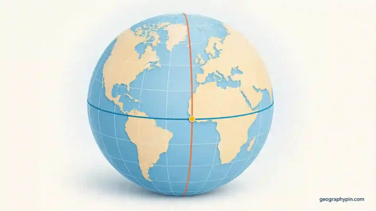
Latitude and longitude are angular coordinates that identify a place on Earth. Latitude tells how far north or south of the Equator a point lies, from 0° to 90°; longitude tells how far east or west of the prime meridian it lies, from 0° to 180°. Read an ordinary pair as latitude first, longitude second.
How to use this article: Compare latitude and longitude at a glance, see how the grid creates one point, follow the four-part coordinate check, or use the worked conversion.
What Latitude and Longitude Mean
Latitude and longitude form a geographic coordinate system. Each value is an angle measured from a reference line on a model of Earth; together, the two values identify where a parallel and a meridian meet.
Latitude Versus Longitude at a Glance
| Feature | Latitude | Longitude |
|---|---|---|
| Position measured | North or south | East or west |
| Zero reference | Equator | Zero-longitude reference near Greenwich |
| Range | 0° to 90° N or S | 0° to 180° E or W |
| Grid-line name | Parallel | Meridian |
| Direction the lines run | East–west | North–south |
| Spacing on Earth | Roughly consistent | Widest at the Equator; converges at the poles |
The line direction causes a common mix-up: latitude lines run east–west, but latitude measures north–south position. Longitude lines run north–south, but longitude measures east–west position.
The Equator is 0° latitude and divides the Northern and Southern hemispheres. Basic maps describe 0° longitude as the Greenwich prime meridian, but modern satellite-based coordinates use the nearby International Reference Meridian. NOAA places modern 0° longitude about 334 feet (102 meters) east of the historic Greenwich marker; that distinction does not change ordinary map-reading practice.
On the opposite side of Earth, 180°E and 180°W describe the same meridian, often called the antimeridian. At either pole, all meridians meet, so changing the longitude does not produce a different physical point.
How the Coordinate Grid Works on a Map
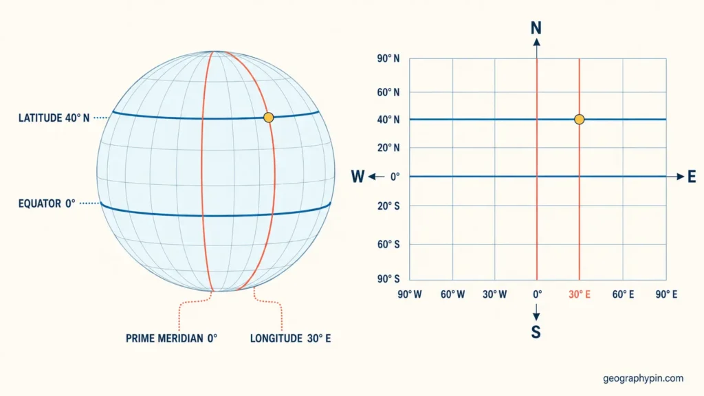
A map or globe may show a network of parallels and meridians called a graticule. Parallels remain parallel to the Equator, while meridians extend from pole to pole. The labels around the map tell you which latitude and longitude each line represents.
How the Grid Locates One Point
To plot a coordinate on a paper map, treat the two values as an address with two parts:
- Find the latitude labels and locate the required parallel; N or S tells you its side of the Equator.
- Find the longitude labels and locate the required meridian; E or W tells you its side of the zero-longitude reference.
- Mark the place where that parallel and meridian cross.
- If the coordinate falls between printed lines, estimate its fractional position between them.
Degrees are angular units, not fixed miles on the ground. One degree of latitude covers about 69 miles (111 kilometers), while one degree of longitude covers about 69 miles (111 kilometers) at the Equator, about 35 miles (56 kilometers) at 60° north or south, and approaches zero at the poles.
A pair normally describes a point, not the full area of a place. A landmark guide can provide a single pair, as in GeographyPin’s page showing where Big Ben is located. A large feature needs bounds or a coordinate range; the guide to where the Black Sea is located demonstrates that difference.
How to Read Latitude and Longitude Coordinates
Start by identifying the notation, then translate each value into a hemisphere. In the common decimal-degree pair 40.6892, -74.0445, the first value is 40.6892° north because it is positive latitude. The second is 74.0445° west because it is negative longitude.
The Four-Part Coordinate Check
- Format: Decide whether the pair uses decimal degrees, degrees and decimal minutes, or degrees, minutes, and seconds.
- Order: For ordinary geographic writing, expect latitude first and longitude second unless labels or a technical format say otherwise.
- Range: Latitude must fall between −90° and 90°; longitude in the usual signed system must fall between −180° and 180°.
- Direction: North and east are normally positive; south and west are normally negative. Hemisphere letters can express the same directions without signs.
The example can be read aloud as “forty point six eight nine two degrees north, seventy-four point zero four four five degrees west.” On a map, locate the 40.6892°N parallel and the 74.0445°W meridian, then use their intersection.
The Coordinate-Order Trap
Latitude-first is a common human-readable convention, but it is not universal. GeoJSON positions use longitude first and latitude second because they follow x, y order. Mapping software, spreadsheets, and APIs may also label fields explicitly, so the format’s documentation outranks any memory rule.
A range check can sometimes expose a reversal. In 120, 35, 120 cannot be latitude because latitude stops at 90, so a longitude-first interpretation is likely. If both numbers fall between −90 and 90, however, the values alone cannot prove their order; check the labels, expected region, or a map preview.
Coordinate Formats: DD, DMS, and DDM
The same location can be written in several notations. Do not compare the strings digit for digit until both have been converted to the same format.
| Format | Example | How to recognize it |
|---|---|---|
| Decimal degrees (DD) | 40.6892, -74.0445 | Each coordinate is one decimal number |
| Degrees, minutes, seconds (DMS) | 40° 41′ 21.12″ N, 74° 2′ 40.20″ W | Uses degrees, arcminutes, and arcseconds |
| Degrees and decimal minutes (DDM) | 40° 41.352′ N, 74° 2.670′ W | Uses whole degrees and decimal minutes, but no seconds |
There are 60 arcminutes in one degree and 60 arcseconds in one arcminute. The prime and double-prime symbols refer to subdivisions of an angle, not time. A value such as 41.352′ is decimal minutes; it must not be read as 41 minutes and 352 seconds.
Hemisphere letters replace the job of a sign: N and S belong to latitude, while E and W belong to longitude. A clean coordinate should use either 74.0445° W or -74.0445° for western longitude, not a negative number followed by W.
How to Convert Coordinates
To convert DMS to decimal degrees, calculate degrees + minutes ÷ 60 + seconds ÷ 3,600. Work with the absolute values first, then make the result negative for south or west.
Worked DMS-to-Decimal Example
Convert 40° 41′ 21.12″ N, 74° 2′ 40.20″ W as follows:
- Latitude:
40 + 41 ÷ 60 + 21.12 ÷ 3,600 = 40.6892. - Longitude magnitude:
74 + 2 ÷ 60 + 40.20 ÷ 3,600 = 74.0445. - Because the longitude is west, apply a negative sign. The result is
40.6892, -74.0445.
Decimal Degrees to DMS
Reverse the process by keeping the whole-number degrees, multiplying the decimal remainder by 60 to get minutes, then multiplying the remaining minute fraction by 60 to get seconds. For 40.6892°, the calculation gives 40 degrees, 41 minutes, and 21.12 seconds.
Round only at the end so that small errors do not accumulate. For quick checks, batch files, or conversion among DD, DMS, DDM, UTM, MGRS, and other supported systems, use GeographyPin’s coordinate converter.
Precision, Accuracy, and Datums
A coordinate with many decimal places looks exact, but displayed precision and real-world accuracy are different. Precision tells you how finely the value is written; accuracy tells you how close it is to the true position.
What Decimal Places Actually Tell You
The table gives the approximate north–south spacing represented by one unit in the last decimal place. It uses the rounded relationship of roughly 69 miles (111 kilometers) per degree of latitude, so it is a scale guide rather than an accuracy promise.
| Decimal places | Smallest displayed step | Approximate north–south spacing |
|---|---|---|
| 2 | 0.01° | 0.69 miles (1.1 kilometers) |
| 3 | 0.001° | 364 feet (111 meters) |
| 4 | 0.0001° | 36 feet (11 meters) |
| 5 | 0.00001° | 3.6 feet (1.1 meters) |
Table downloads (3)
- How latitude and longitude differ (7 × 3)View tableDownload CSV
- Three common ways to write the same coordinate pair (4 × 3)View tableDownload CSV
- Approximate latitude spacing by decimal places (5 × 3)View tableDownload CSV
Longitude spacing is similar near the Equator but becomes smaller toward the poles. More digits therefore do not represent the same east–west ground distance everywhere, and adding digits cannot improve a location collected from an inaccurate GPS reading or a rough map click (USGS).
Why the Datum Matters
A datum or reference frame defines the Earth model and origin used for the coordinates. Modern consumer mapping and GPS workflows commonly use WGS 84, the global reference maintained by the National Geospatial-Intelligence Agency. Two identical-looking coordinate pairs tied to different datums can represent different positions on the ground.
For ordinary location sharing, the app usually handles this context. For surveying, property boundaries, engineering, scientific datasets, or emergency work, record the complete coordinate reference system and do not assume that every latitude-longitude pair uses the same datum.
Common Coordinate Mistakes
- Reversing the pair: A latitude-longitude input placed into longitude-latitude software may land far from the intended location.
- Mixing signs and hemisphere letters: Use west or a negative longitude, not both in the same value.
- Confusing line direction with measurement: Parallels run east–west but measure north–south position; meridians do the reverse.
- Mixing DD, DDM, and DMS: Decimal minutes are not seconds, and a decimal degree cannot be inserted unchanged into a minutes field.
- Trusting extra digits: A long coordinate string may report false precision if its source was approximate.
- Ignoring the datum: This may be harmless for a casual map pin but consequential for precise work.
- Treating a point as an area: A city center, landmark, coastline, and national boundary require different geographic representations.
A Ten-Second Final Check
Before sharing or entering a pair, confirm the format, coordinate order, valid ranges, hemisphere signs, expected region, and datum when precision matters. A quick map preview catches many errors that the numbers alone cannot reveal.
Frequently Asked Questions
Are latitude and longitude the same as GPS coordinates?
Not exactly. GPS is a satellite-based positioning system, while latitude and longitude are a way to express a position. A GPS receiver may display latitude and longitude, but it can also provide data that software converts into UTM or another coordinate system.
What is the difference between geocoding and reverse geocoding?
Geocoding turns a place name or street address into coordinates. Reverse geocoding takes coordinates and returns a nearby human-readable place or address. The returned address may be approximate because a coordinate point and an address record do not always match exactly.
Do latitude and longitude include elevation?
No. A basic pair gives a two-dimensional horizontal position. A third value can add ellipsoid height or another form of elevation, but that height also needs a stated vertical reference for precise use.
Can one city have more than one correct coordinate?
Yes. One source may use city hall, another a mapped center, a population-weighted center, or a transport hub. The pair can be valid for its chosen point, so the feature represented should be stated when the distinction matters.
What Did We Learn Today?
Latitude measures angular position north or south of the Equator, while longitude measures east or west of the zero-longitude reference; their intersection identifies a point. Read ordinary pairs latitude first, but confirm the required format because systems such as GeoJSON reverse the order. The safest method is to check notation, order, range, direction, precision, and datum before using the coordinates.
Sources & Data Notes
Definitions and distance guidance were checked against NOAA’s National Ocean Service and the U.S. Geological Survey; datum context came from NOAA’s National Geodetic Survey and the National Geospatial-Intelligence Agency; GeoJSON order came from RFC 7946; and the worked notation example was checked with GeographyPin’s Coordinate Converter. Ground distances are rounded, and longitude spacing varies with latitude. Zurab Koniashvili (Z.K. Atlas) completed the final factual and editorial review and accepts responsibility for publication; AI tools may have assisted with language refinement and the creation or editing of visual materials.