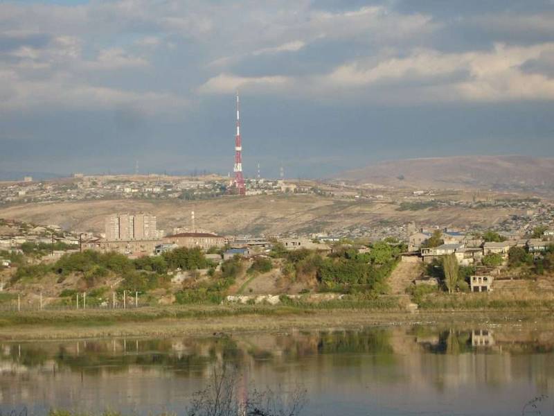
Yerevan Lake is an artificial reservoir on the Hrazdan River in Yerevan, formed in 1963–1966 and inaugurated in 1967. It covers about 0.25 sq mi (0.65 km²), with maximum depth near 59 ft (18 m), total storage ~4.8–5.0 million m³, and sits at 2,979 ft (908 m). Its dam has five gates and a maximum release capacity reported up to 286 m³/s.
Why Yerevan Lake Matters
Created to tame seasonal fluctuations of the Hrazdan River and support irrigation canals, Yerevan Lake is one of the city’s most consequential mid-20th-century public works. Its design gives Yerevan a controlled release point downstream, helping the city manage storm peaks and summer lows while supporting public recreation along newly landscaped edges (renovations were reported in 2022).
Coordinates are approximately 40.1597° N, 44.4768° E; the surface area averages 0.65 km² (0.25 sq mi), with a maximum depth of ~59 ft (18 m) and useful storage reported at ~0.7 million m³ within a total volume near 4.8 million m³. These fundamental figures, plus the siting between two large districts, explain why the lake doubles as both hydraulic node and neighborhood amenity.
Engineering the Reservoir
The reservoir was formed by constructing an earthen dam lined with reinforced concrete slabs from 1963 to 1966; it opened in 1967. The dam is ~480 m (1,575 ft) long and ~29 m (95 ft) high. The outlet works include a bottom spillway on the right bank, and the structure features five gates with a reported maximum release capacity of up to ~286 m³/s when fully opened—capability that matters for flood routing. Two historic irrigation canals (Echmiadzin and Parakar) start at the lake.
Structure & Materials
An embankment (earth-fill) design over basaltic ground is clad with concrete slabs to resist wave erosion and provide stable slopes. This pragmatic Soviet-era typology prioritized locally available materials while allowing later maintenance, which the city has undertaken periodically as the waterfront urbanized.
Operations: Inflow, Outflow & Control
The Hrazdan River is the primary inflow. Releases are regulated via the gated outlet and spillway to maintain target levels for flood moderation and to feed canals. The reservoir’s urban setting means operations must balance hydrologic function with shoreline safety and recreation. A concise technical overview of the Hrazdan basin’s infrastructure and pressures is available in the EU-supported River Basin Management Plan for Hrazdan.
| Metric | Value |
|---|---|
| Surface Area | 0.25 sq mi (0.65 km²) |
| Max / Avg Depth | 59 ft (18 m) / ~26 ft (~8 m) |
| Surface Elevation | 2,979 ft (908 m) above sea level |
| Total / Useful Storage | ~4.8 million m³ / ~0.7 million m³ |
| Dam Type / Facing | Earthen embankment / reinforced-concrete slabs |
| Dam Length / Height | 1,575 ft (480 m) / 95 ft (29 m) |
| Gates / Max Release | Five gates / up to ~286 m³/s |
| Primary Inflow | Hrazdan River |
| Canals Originating | Echmiadzin & Parakar canals |
| Key Dates | Built 1963–1966; opened 1967 |
All figures above per consolidated public sources.
Urban Hydrology & Micro-Climate
In a semi-dry climate, holding back spring flows and modulating summer releases offers predictable hydraulics for canals and mitigates flood pulses in the Hrazdan Gorge. The lake’s storage also helps shape the city’s micro-climate by expanding evaporative surface and creating breezy, cooler edges in hot months—benefits recognized in city planning narratives and waterfront upgrades reported in 2022.
As Yerevan’s urban footprint expanded, more sealed surfaces sent runoff—and its pollutants—toward rivers. Basin documents identify untreated or partially treated wastewater and industrial effluent as persistent pressures in the Hrazdan system, underscoring why lake-edge landscaping, litter interception, and sewer upgrades matter for water quality and public use.
Water Quality & Environmental Management
Scientific monitoring at Lake Yerevan has documented cyanobacteria (blue-green algae) such as Microcystis, Dolichospermum, and Planktothrix, with microcystins detected at low microgram-per-liter levels during summer peaks (e.g., observations reported for 2012–2013 and summarized again in 2023 literature reviews). These findings guide local risk awareness for blooms.
Beyond the lake itself, city and national reports describe chronic pressures from untreated municipal wastewater entering rivers—including the Hrazdan—before reaching downstream systems. Recent policy steps and donor programs (EU, ADB) target upgrades to wastewater treatment and basin management, including technical assistance announced in January 2025 for “Lake Yerevan & Hrazdan Gorge Rejuvenation.”
Timeline at a Glance
| Year | Event | Notes / Source |
|---|---|---|
| 1963–1966 | Construction of earthen dam and impoundment | Embankment lined with concrete slabs. |
| 1967 | Reservoir opened | Operational purpose: flow regulation & irrigation. |
| 1976 | Trolleybus accident; rescue by Shavarsh Karapetyan | 20 lives saved (official commemoration). |
| 2012–2013 | Documented cyanobacteria blooms | Microcystis, Dolichospermum, Planktothrix; microcystins detected. |
| 2022 | Renovations & park improvements reported | Pollution level “minimized” per public summary. |
| 2025 | ADB technical assistance approved | Preparation TA for lake & gorge rejuvenation. |
Culture, Safety & the 1976 Trolleybus Rescue
On 16 September 1976, a trolleybus plunged from the dam road into the lake. Finswimmer Shavarsh Karapetyan (then 23) repeatedly dived to the vehicle and pulled dozens out; official commemorations credit him with saving 20 lives. The accident remains a key part of Yerevan’s civic memory and an enduring safety lesson for reservoir roads and barriers.
For a concise biography and corroborating details (depth, distance from shore, sequence of dives), see the encyclopedia entry on Karapetyan and the dedicated page about the 1976 incident.
Visiting & Orientation
The lake is a few kilometers southwest of central Yerevan; the U.S. Embassy complex stands along its northern shore, with Hrazdan Gorge viewpoints nearby. Paths and seating areas offer sunset views across the water, while bridges and roads connect to the city’s stadiums and parks. For a quick factsheet on size, location, and structure, the public encyclopedia page is a useful starting point.
FAQ
How big and how deep is Yerevan Lake?
About 0.25 sq mi (0.65 km²) in area; maximum depth is ~59 ft (18 m), with an average near ~26 ft
When was the reservoir built and opened?
Construction: 1963–1966. Opening: 1967 (some sources reference works through 1970).
What type of dam is it?
Earthen (embankment) dam with reinforced-concrete facing; ~480 m long and ~29 m high.
Does Yerevan Lake have water-quality issues?
Cyanobacteria have been documented; microcystins were detected at low μg/L levels in summer peaks, prompting ongoing monitoring. Upgrades to wastewater systems in the basin are in progress.
What happened in the 1976 trolleybus incident?
A trolleybus fell from the dam road; athlete Shavarsh Karapetyan rescued passengers, with 20 lives saved according to official commemorations.
What Did We Learn Today?
- Yerevan Lake is a mid-1960s earthen-dam reservoir central to the city’s hydrology and canals.
- Key specs: 0.65 km² area, ~18 m max depth, ~4.8 million m³ total volume, ~908 m elevation.
- Monitoring has recorded cyanobacteria; basin wastewater upgrades remain vital.
- The site is intertwined with public memory through the 1976 rescue by Shavarsh Karapetyan.
- International technical assistance in 2025 supports future rejuvenation of the lake and gorge.