A familiar map of the United States often leaves Alaska and Hawaii in small boxes, making a very large and varied country look simpler than it is. Understanding its geography means connecting the mountain systems, broad interior plains, river networks and cities, while keeping the map’s coverage clear.
The United States is a federal republic of 50 states, with Washington, D.C., as its capital. Its geography combines eastern highlands, broad interior plains and major western mountain systems, alongside Alaska and Hawaii. Rivers, ocean exposure and elevation create strong regional contrasts in climate, settlement and land use.
How to use this article: Clarify which parts of the country a map includes, compare land and water measurements, or follow how river basins connect regions.
1. Locate the United States and read its map
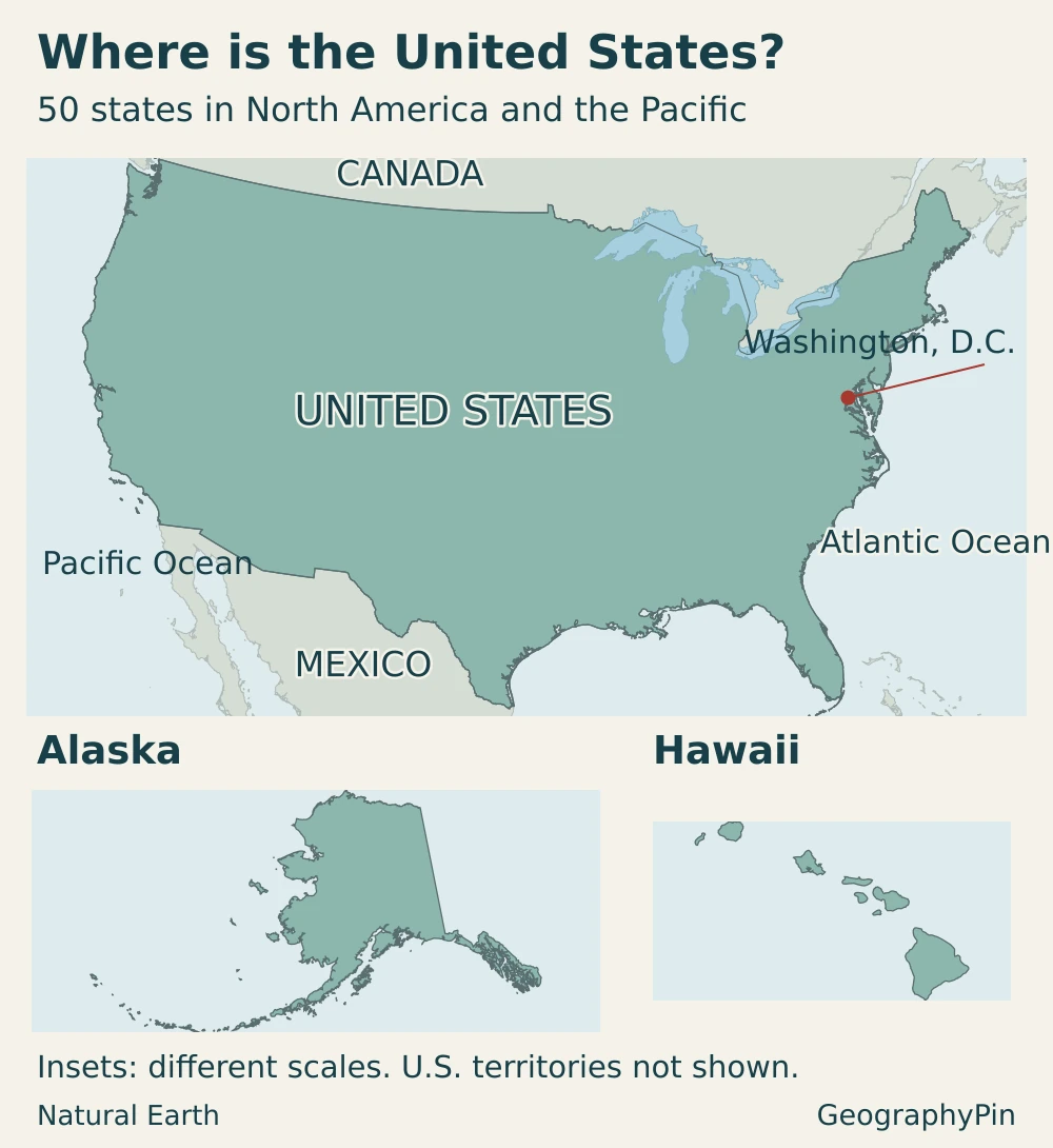
The contiguous United States lies between Canada and Mexico, with the Atlantic Ocean to the east and the Pacific to the west. Alaska occupies the northwestern corner of North America, separated from the contiguous states by Canada. Hawaii is a Pacific island state, not part of the North American mainland.
The contiguous states are not the whole country
“Contiguous United States” means the 48 connected states and the District of Columbia. The 50-state national scope also includes Alaska and Hawaii. A map focused on the contiguous states can be useful, but it should not be mistaken for a complete map of the country.
Washington, D.C., is a federal district, not a state. Washington state is on the Pacific coast and is a different place. The national capital and the 50 state capitals answer different questions; the U.S. states, capitals and abbreviations guide supplies the detailed state reference.
U.S. territories, including Puerto Rico and Guam, have political relationships with the United States but are not among the 50 states. The population and area figures below use the states-and-D.C. scope, not every territory under U.S. sovereignty. This distinction matters when comparing a national table with a map of all U.S. jurisdictions.
Alaska and Hawaii are commonly repositioned into insets so that their outlines remain readable. Such boxes change their displayed position and may use different scales. They show membership and shape, not the actual distance from California or a valid side-by-side comparison of land area.
2. Country facts: population, area and scope
| Item | Reference |
|---|---|
| Official name | United States of America |
| Capital and federal government seat | Washington, D.C. |
| Population | 341,784,857 on July 1, 2025; Census Bureau Vintage 2025 resident estimate |
| Total area in the cited Census reference | 3,796,742 square miles (9,833,517 square kilometers); 2010 geographic reference |
| Land area in the same reference | 3,531,905 square miles (9,147,593 square kilometers) |
| National scope used here | 50 states and the District of Columbia; territories excluded from these totals |
| Language status | English designated official by executive order on March 1, 2025 |
| Currency | U.S. dollar (USD) |
| Government | Federal constitutional republic |
Land area and total area measure different things
The Census Bureau’s cited area table separates land from water. Its water categories include inland, coastal, Great Lakes and territorial water; total area is therefore not interchangeable with land area. The figures above preserve one explicitly dated reference rather than combining a land measurement from one dataset with a total from another.
Area differences between reputable references do not necessarily mean a country has gained or lost land. Water coverage, shoreline treatment and geographic datasets can differ. These 2010 reference figures are not presented as a newly measured 2026 coastline or a global size ranking.
The population figure is also dated: it is a July 2025 estimate, not the April 2020 census count or a live population clock. Annual estimates can be revised in later vintages. A changing counter and a published annual estimate are not two directly competing measurements of the same moment.
3. Mountains, plains and the shape of the continent
The most useful first picture is a broad interior between eastern highlands and the more extensive western mountain-and-plateau country. That pattern is a starting point, not a claim that the middle is entirely flat or the West is one continuous mountain range. Physical regions also cross state borders, so state outlines alone cannot explain the landscape.
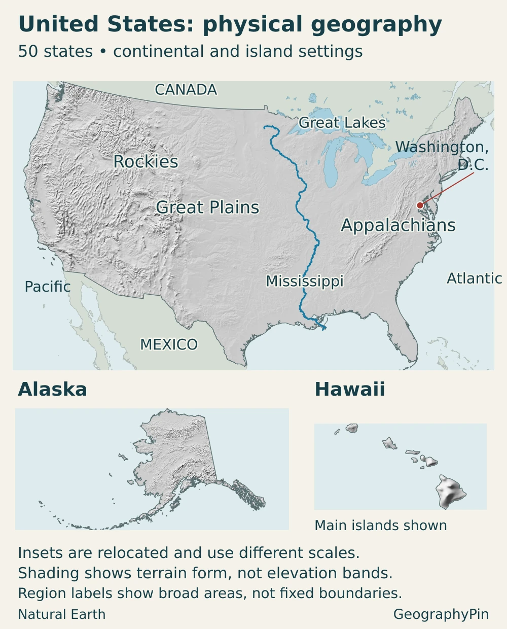
| Region | Where it fits | Geographic connection |
|---|---|---|
| Atlantic and Gulf coastal plains | Low-lying terrain along much of the eastern and southern margins | Coasts, estuaries and lower river reaches connect inland areas with the sea |
| Appalachian Highlands | Eastern interior, including several ranges, ridges and plateaus | Valleys and gaps provide routes through an otherwise varied upland belt |
| Interior plains and Great Plains | Broad central interior; Great Plains toward the Rocky Mountain front | Large drainage networks and extensive agricultural landscapes cross state boundaries |
| Rocky Mountains | Western interior, extending beyond the U.S. border | High terrain divides drainage and affects routes, snow accumulation and settlement |
| Intermountain basins and plateaus | Between the Rockies and Pacific mountain systems | Basins, ranges and elevated plateaus create very different local environments |
| Pacific mountain systems | Western margin, including the Cascades and Sierra Nevada | Mountain barriers help separate wetter windward areas from drier interiors |
| Alaska and Hawaii | Northwestern mainland and central Pacific respectively | Their distinct terrain and ocean settings broaden the national picture |
The Appalachians are not simply a smaller version of the Rockies. Their ridges, valleys and plateaus reflect a different geological history, while their lower passes have helped channel movement between the Atlantic side and the interior. “Mountains” is useful as a broad category but does not describe every part of a highland region.
Likewise, the western interior contains more than mountain peaks. The Basin and Range has repeated elongated ranges separated by basins. The Colorado Plateau is elevated country cut by deep canyons. A high plateau can look relatively level from above even though it stands far above sea level.
The Cascades and Sierra Nevada also differ from each other. The Cascades include a volcanic arc, while the Sierra Nevada is a major tilted fault block. Grouping them together for a national overview should not imply identical formation or scenery.
Across the Central Lowland, past glaciation helped shape the terrain. Lakes, drainage patterns and rolling surfaces preserve that history. The term “plain” does not mean that every field, river valley or city lies on a perfectly horizontal surface.
The physical map of the USA provides a more detailed landform-and-water reference. This country profile uses those features to explain the wider national pattern rather than reproduce a complete mountain or river inventory.
4. Climate, rivers and environmental contrasts
No single climate description fits the entire United States. Latitude affects the sunlight available through the year; elevation changes local conditions; and mountains, prevailing winds and proximity to water shape precipitation and temperature. A national average conceals the contrasts that matter to a particular landscape.
Western mountain barriers can favor precipitation on exposed slopes while leaving sheltered areas drier. NOAA’s comparison of U.S. precipitation patterns also highlights the wet southern Alaskan coast, where ocean conditions and mountains interact. That does not make all of Alaska wet: its far-northern and interior environments differ sharply.
Hawaii adds tropical oceanic settings, but even there rainfall is uneven. Windward slopes can receive much more rain than nearby leeward areas. “Tropical” does not mean constant rain everywhere, just as “northern” does not describe a single Alaskan climate.
River basins connect places that state maps separate
The Mississippi and its tributaries, including the Missouri and Ohio, collect water across a large part of the interior. The drainage system includes land in 31 states and two Canadian provinces. A river basin follows the land draining toward an outlet, not a political boundary.
This creates upstream–downstream connections. Water, sediment and nutrients entering tributaries can affect places far away along the network. Agriculture, cities and river management therefore interact across jurisdictions; the river visible beside one town is part of a much larger system.
The Great Lakes—Superior, Michigan, Huron, Erie and Ontario—form another major freshwater system. Lake Michigan lies entirely within the United States; the other four are shared with Canada. Their water supports communities, transport and other uses, connecting the northern interior across an international border.
Not every western basin drains to the sea. The Great Basin hydrologic region has no natural surface connection to the ocean. Water collects within its drainage system rather than following a continuous river route to the coast. The contrast with an outward-draining river network helps explain why water availability can vary so much between neighboring regions.
Climate descriptions and hazard maps answer different questions. A broad regional pattern is not a forecast for a particular day or a boundary beyond which extreme weather cannot occur. Lake-effect snow, hail, flooding and drought depend on particular combinations of conditions, not simply the name of a state.
5. People, cities and languages
The population is not spread evenly across the national outline. Large metropolitan areas, smaller cities, agricultural districts and sparsely populated landscapes coexist. An expansive rural-looking map can therefore contain a predominantly urban population.
Under the Census Bureau’s 2020 urban-area definition, 80.0% of the U.S. population lived in urban areas. This is a dated statistical classification, not a claim that four-fifths of the country’s land is built over. Urban areas also differ from city governments and metropolitan statistical areas, whose boundaries serve other purposes.
New York was the largest U.S. city by resident population within city limits in the July 1, 2025 estimates, with 8,584,629 residents. That is a city-proper figure, not the population of the wider metropolitan area.
That distinction is important when comparing places such as New York, Los Angeles or Chicago. The population inside a municipality’s legal limits is not the population of its wider urban footprint or economic region. A ranking can change when its geographic unit changes, even without anyone moving.
Coastal access, inland waterways and transport connections have helped shape settlement, but terrain is not destiny. Investment, institutions, migration and established employment networks also influence where people live. Flat land can support farming without becoming a major city, while mountain valleys can contain important urban centers.
English was designated the official language by a March 2025 executive order. Older statements that the United States has no official language at the federal level no longer describe that designation. The order itself did not require agencies to stop producing documents or providing services in other languages; that is not a guarantee that every agency offers the same services. Legal status should also be distinguished from everyday language use: Spanish, Indigenous languages and many other languages are spoken across the country.
The Census Bureau’s 2020–2024 survey figures report that 22.3% of people aged five and older spoke a language other than English at home. That does not mean they could not speak English. The survey describes home language, not a simple division between English speakers and everyone else.
6. Government and economy in their geographic setting
The United States is a federal republic. The federal government has legislative, executive and judicial branches; states also have their own governments. Federally recognized American Indian and Alaska Native tribes have a government-to-government relationship with the United States and retain certain inherent rights of self-government; they are not simply another category of local government. Washington, D.C., is the national political center, but the economy and population are distributed among many metropolitan and regional centers rather than one capital city.
Political geography and economic geography overlap without matching exactly. A labor market can extend across a state line, a river basin can cross many states, and an urban area can include several local governments. The boundary used for a policy or statistic should therefore match the question being asked.
The country’s geographic variety supports different combinations of agriculture, manufacturing, energy, transport and services. No region is limited to a single industry. Cities and rural areas have mixed economies, and a place’s role changes as infrastructure, technology and demand change.
Two regional examples make these connections concrete. Corn production is concentrated in the Heartland, rather than spread evenly across the national territory. The crop links farms with livestock feeding, ethanol production and food processing, so an agricultural landscape supports activities well beyond the field itself.
Energy production has a different regional concentration. Texas and New Mexico were the two leading crude-oil-producing states in 2025, according to the Energy Information Administration. Their prominence illustrates the importance of resource location, while changes in drilling technology help explain why output is not fixed by geology alone.
Neither example defines the whole economy of a state or region. Farming districts also contain service businesses, and energy-producing states include large urban economies. Geography identifies concentrations and connections, not exclusive economic roles.
Frequently Asked Questions
Does “continental United States” always mean the 48 connected states?
No. In the U.S. Board on Geographic Names definition, the continental United States includes Alaska: 49 states and D.C., excluding Hawaii. “Conterminous,” commonly called “contiguous,” refers to the connected 48 states and D.C.
Are the Great Plains and the Midwest the same region?
No. The Great Plains is a physical-geographic region; the Midwest is used for a cultural and statistical region. Their coverage overlaps in places, but the boundaries and purposes are different.
Can a state belong to more than one physical region?
Yes. State borders are political boundaries, while physical regions describe landscape characteristics. One state can include plains, mountains, basins or coastal terrain, so a single regional label may conceal important internal differences.
What Did We Learn Today?
The United States makes more sense when its political map is read alongside terrain, drainage and settlement. Eastern highlands, interior plains and western mountains create broad contrasts, while Alaska and Hawaii add environments missing from a contiguous-state view. Rivers connect regions across borders, cities concentrate people within a much larger land area, and clearly dated definitions keep population, area and language facts from becoming misleading shortcuts.
Sources & Data Notes
Population uses the Census Bureau’s July 1, 2025 Vintage 2025 resident estimate. Area uses the explicitly dated 2010 Census geographic reference for the 50 states and D.C.; total includes the source’s water categories. Urban share refers to the 2020 classification, while home-language data cover 2020–2024 and people aged five and older. These are different reference periods, not simultaneous 2026 observations. Landscape groupings are explanatory, not a new official regional classification; climate descriptions are broad patterns rather than forecasts.
- Census Bureau: population and home-language figures
- Census Bureau: area measurements and water definitions
- Census Bureau: 2020 urban-area facts
- National Park Service: physiographic provinces
- National Park Service: Basin and Range
- National Park Service: Cascade–Sierra mountains
- National Park Service: Central Lowland
- NOAA: precipitation patterns
- EPA: Mississippi–Atchafalaya basin
- USAGov: official-language designation
- USAGov: federal branches
- USDA Economic Research Service: corn production and uses
- Energy Information Administration: 2025 crude-oil production
- Bureau of Indian Affairs: federally recognized tribes
- Executive Order 14224: language designation and agency services
- Census Bureau: July 2025 city population estimates
- National Park Service: Great Basin drainage
- USGS: national geographic scope definitions
- Canada Water Agency: Great Lakes geography and uses
- EPA: Great Lakes water uses
Maps and illustration: Original GeographyPin maps use Natural Earth country, lake, river and populated-place data with its shaded-relief raster, available under public-domain terms. Each map panel uses its own Albers equal-area projection. Relief pixels are reprojected and sampled from the source raster, then clipped to land outlines; shading represents terrain form rather than measured elevation bands. Washington, D.C., and the Mississippi River come from the source geographic features. Regional names locate broad areas, not official physiographic boundaries. Alaska and Hawaii are relocated, different-scale insets; only the main Hawaiian islands are shown, and U.S. territories are omitted. The featured illustration clips a stars-and-stripes motif inside the country outlines; it is decorative, not a full rectangular flag.