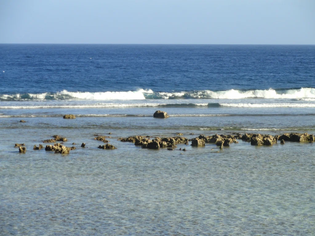
Guam’s most revealing contrast is inland: rain falling on the northern limestone plateau can disappear into the ground, while water in the southern volcanic hills follows surface valleys. Reading that difference alongside Hagåtña, Tumon and the Mariana chain gives a fuller picture than either a beach photograph or a political label alone.
Guam is an organized, unincorporated U.S. territory at the southern end of the Mariana Islands in the western Pacific. A limestone plateau dominates its north, while volcanic hills shape much of the south. Hagåtña is the capital. Guam is geographically Mariana but politically separate from the Commonwealth of the Northern Mariana Islands.
How to use this article: Compare the two landscapes, follow fresh-water pathways, or distinguish the capital from Tumon.
1. Locate Guam Within the Mariana Islands
Guam sits in the western Pacific Ocean, with the Philippine Sea to its west. The Mariana chain continues northward from the island. On a regional locator, Guam and the Northern Mariana Islands belong to the same island chain, but their political labels should remain separate.
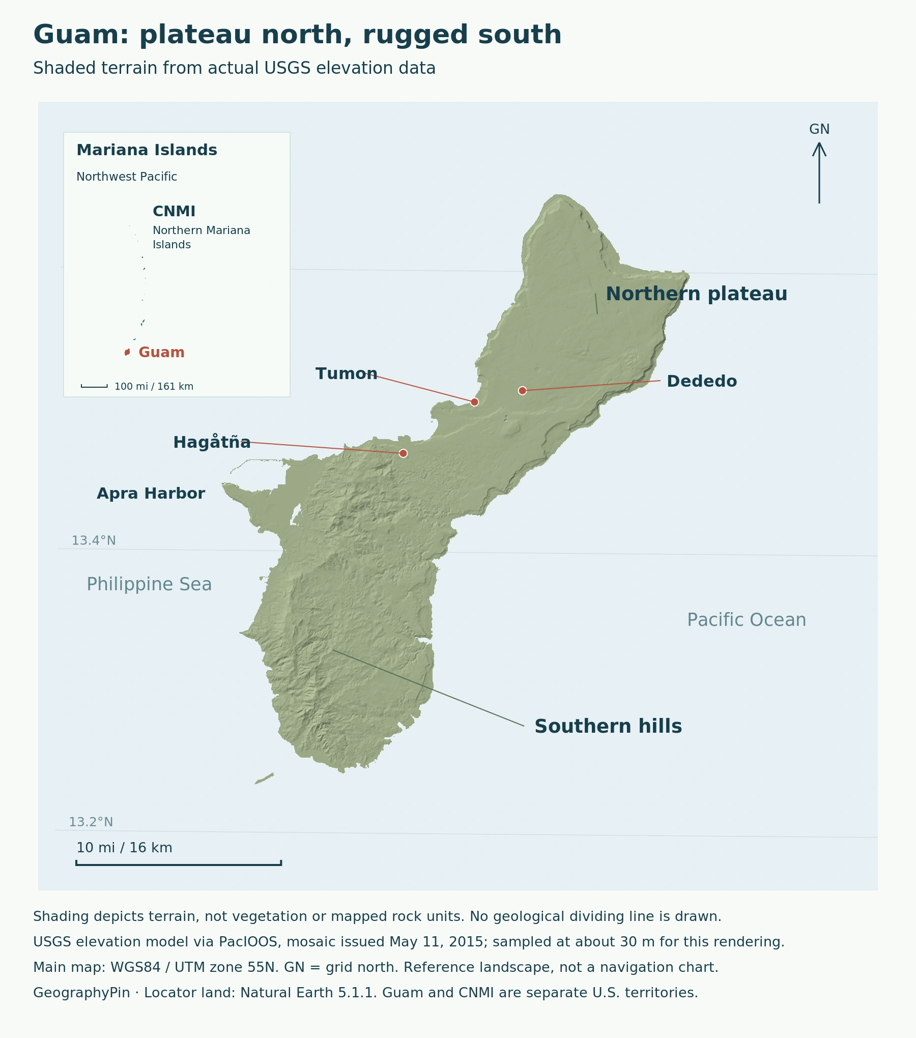
At island scale, two patterns stand out: the broader northern plateau and the more rugged southern hills. Guam is about 30 miles (48 kilometers) long, according to the USGS physical overview, so both landscapes fit within a relatively short island. Yet their rocks and drainage behave differently.
Its land area is about 210 square miles (544 square kilometers), rounded from the Census Bureau’s 2020 geographic record. That measures land, not the surrounding territorial water. The map’s inset locates the island regionally; the larger view makes its contrasting terrain legible.
2. Limestone North, Volcanic South
A plateau is not a flat island
The University of Guam’s Water and Environmental Research Institute describes the north as an undulating limestone plateau. It is elevated terrain with depressions, slopes and coastal cliffs, not a plain lying at sea level. Much of its limestone formed from marine carbonate material above an older volcanic foundation.
Southern Guam has rugged volcanic highlands, but limestone also occurs there. Conversely, volcanic rocks appear locally in the north. “Limestone north, volcanic south” is a useful first reading of the landscape, not a rule that every rock changes at one straight line across the island.
| Region | Characteristic landform | Water pathway |
|---|---|---|
| Northern plateau | Undulating limestone, depressions and cliffs | Much rainfall infiltrates underground |
| Southern highlands | Volcanic hills and valleys, with limestone outliers | More developed surface-stream drainage |
The USGS distinguishes Guam from volcanically active islands farther north: Guam itself is not volcanically active. “Volcanic” here describes the origin of rocks and landforms, not an erupting crater or a current lava field.
3. How Rock Controls Fresh Water
Underground recharge and surface streams
Rainfall does not follow the same route everywhere. WERI’s hydrology account explains that the northern limestone readily admits water, allowing rain to infiltrate and replenish the aquifer. This supplies the Northern Guam Lens Aquifer.
The relatively impermeable volcanic rocks of the south favor surface runoff and a developed stream network. On the northern plateau, much fresh water instead leaves through coastal springs and seeps. A map with few surface rivers can therefore conceal substantial underground movement.
Local exceptions include short-lived streams around northern volcanic outcrops and surface drainage over less-permeable, clay-rich limestone near the plateau’s southern margin.
Guam’s tropical climate supplies this system unevenly through the year. WERI describes a wetter season centered on July through November and a drier January–May period, with intervening transition months. Rainfall also varies considerably between years. The seasonal cycle affects when water replenishes the ground and when runoff moves through valleys.
Land and reef are connected by that runoff. The USGS reef project studies sediment reaching Guam’s nearshore waters; disturbed soil can be carried down from hills during heavy rain. The important geographic link is the whole path from slope to stream to coast, rather than treating an inland hillside and a reef as unrelated environments.
4. Hagåtña, Tumon and the Population Reference
The capital and the tourism coast are different places
Hagåtña is the capital, between Agana Bay and the cliffs of Agana Heights in central Guam. Its government and civic role is different from the visitor-oriented coastal area of Tumon. A photograph of beachfront hotels should not be mistaken for a view of the territorial capital.
Guam’s Department of Land Management records the legal change from Agana to the CHamoru name Hagåtña. The federal territorial statute retains Agana. These references identify the same capital; the separate place name Agana Heights should not be confused with it.
The Guam Visitors Bureau groups Tamuning, Tumon and Harmon together in its village account. It describes Tumon Bay below cliffs leading to the upper plateau, with tourism focused around the bay, commercial and residential activity in Tamuning, and industrial activity in Harmon. Those functions help explain why several neighboring place names appear on a compact map.
The 2020 census counted 153,836 people on Guam, with an April 1 reference date. That is an island-wide census count, not a 2026 estimate or a count for Hagåtña or Tumon. The Census Bureau publishes both municipal and smaller census-designated-place tables, so local comparisons need matching geographic units.
5. A U.S. Territory, Separate From the CNMI
48 U.S.C. § 1421a declares Guam an unincorporated territory of the United States and provides for executive, legislative and judicial branches of territorial government. “Organized” means it has a congressionally established governmental framework; neither term means Guam is a U.S. state.
The Interior Department identifies the 1950 Organic Act as the law that established Guam’s territorial government and conferred U.S. citizenship. Guam is neither one of the 50 states nor an independent sovereign country. It therefore has no separate entry in the world atlas’s 195-country roster.
The Commonwealth of the Northern Mariana Islands, or CNMI, has its own territorial government and constitutional framework. Its islands are not governed as northern districts of Guam. The geographic word “Mariana” describes a chain; the political names identify different jurisdictions within it.
The UN’s March 2026 working paper also identifies Guam as a Non-Self-Governing Territory administered by the United States. This is the international decolonization classification, distinct from the U.S. domestic terms “organized” and “unincorporated.”
What Did We Learn Today?
Guam’s limestone plateau and volcanic hills influence where water travels, both underground and toward the coast. Hagåtña and Tumon represent different settlement functions within that landscape. At the regional scale, Guam belongs to the Mariana chain but remains a separate jurisdiction from the CNMI: physical geography and political geography describe the island in different, complementary ways.
Sources & Data Notes
Sources, dates and map conventions
Population refers to April 1, 2020. Land area is rounded from the Census geographic land field, excluding its separate water field. The north–south comparison is a broad physical pattern with local geological exceptions. WERI’s climate overview supports seasonal context, not current storm conditions or recent rainfall averages. The current federal text supplies domestic status; the March 2026 UN paper supplies the separate international classification.
- Guam Department of Land Management: municipal names and codes
- USGS: Guam reef project and physical overview
- University of Guam WERI: general geology
- University of Guam WERI: general hydrology
- University of Guam WERI: climate overview
- Guam Visitors Bureau: Hagåtña
- Guam Visitors Bureau: Tamuning, Tumon and Harmon
- U.S. Census Bureau: April 1, 2020 population count
- Census TIGERweb: 2020 Guam land-area record
- 48 U.S.C. § 1421a: territorial status and government
- U.S. Interior Department: Guam and the Organic Act
- U.S. Interior Department: Northern Mariana Islands
- UN Secretariat: Guam working paper, March 16, 2026
- Terrain: USGS elevation model via PacIOOS, 2015 mosaic, sampled at about 30 meters; reuse permitted. Shaded relief, not vegetation or geological units. WGS84/UTM55N; historical reference terrain. Locator: Natural Earth 5.1.1, public domain. Place references: Natural Earth and USGS GNIS.
Photograph: Tumon Bay’s reef platform, December 4, 2011. Daderot, via Wikimedia Commons, CC0; resized.
