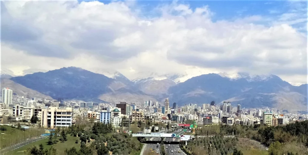
The mountain backdrop is one of Tehran’s clearest geographic clues. Iran’s capital spreads below the Alborz rather than beside the Caspian Sea, on terrain that slopes away from the northern highlands. That setting helps explain the city’s water connections and growth, but its rise to national importance also depended on political decisions.
Tehran is the capital of Iran, in the north of the country at the southern foot of the Alborz Mountains. It is an inland city, separated from the Caspian coast by the mountain range. Tehran city, Tehran Province and the wider urban region are different geographic units and should not share one population figure.
How to use this article: Start with the mountain setting, or connect the capital’s history to Golestan Palace and the historic core. The population table separates city proper from wider geographic units.
1. Where Tehran is on the map
Tehran belongs to the northern edge of Iran’s interior plateau. On a national map, locate the Caspian Sea first, then look south of the Alborz mountain belt. The capital lies on that southern side, not on the wet coastal plain north of the range. The Persian Gulf and Gulf of Oman are much farther south, along a different edge of the country.
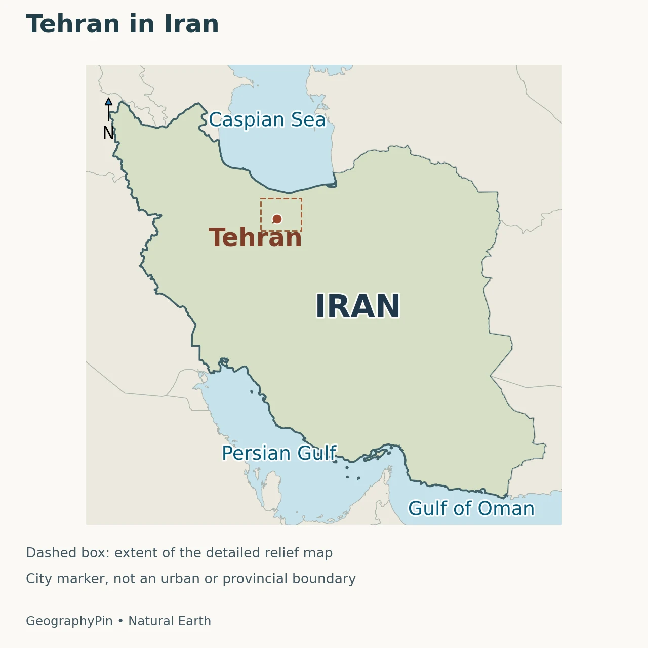
The city’s position makes a two-scale map useful. The Iran locator answers where the capital sits within the country. The closer relief view explains why a short-looking north–south line on a map can cross very different terrain. A city point marks a reference location; it does not show the municipal boundary or the entire built-up area.
Reading the mountain edge
The immediate northern setting is the Alborz foothills. Farther northeast stands Mount Damavand, a distinct volcano within the wider range. Damavand is not the name of the whole mountain backdrop, and a photograph of a snowy ridge above Tehran should not automatically be identified as that particular summit.
The city is also not the same place as the Caspian-facing towns beyond the mountains. A straight line between two points does not describe the route through passes and valleys. For the national terrain framework, the Iran geography article explains how the Alborz, Zagros and interior basins fit together.
2. How Tehran became the capital
Tehran’s role as the capital developed under the Qajar dynasty in the late eighteenth century. Encyclopaedia Iranica’s account of Iranian capitals dates Agha Mohammad Khan’s adoption of Tehran as his capital to 1786. This was a political choice connected with the dynasty’s northern power base, not an inevitable result of the city occupying the most fertile or best-watered site in Iran.
Earlier settlement history matters too. Tehran grew near the much older urban center of Ray. Its later prominence should not be projected backward as though it had always dominated the region. Capitals can become major cities because courts, administration and investment concentrate there; they are not necessarily selected because they already possess the largest population.
Golestan Palace and the historic core
Golestan Palace provides a physical connection to that period. UNESCO describes the palace complex in Tehran’s historic center as a Qajar royal residence and seat of power, with many characteristic features dating from the nineteenth century. It is evidence of the capital’s political and architectural development, not simply a landmark detached from the city’s history.
This distinction helps explain why “What is Iran’s capital?” and “Which cities were important in Persian history?” are different questions. The present answer is Tehran, while earlier dynasties used other centers. A modern capital locator is not a map of every historical seat of government.
3. A city on sloping ground below the Alborz
Tehran is often described as a foothill city because the urban landscape meets the mountain front to the north and extends toward lower, drier ground to the south. This is more informative than giving the entire city a single elevation. A measurement at a northern neighborhood, a central square or an airport can describe different ground heights without any of the measurements being inherently wrong.
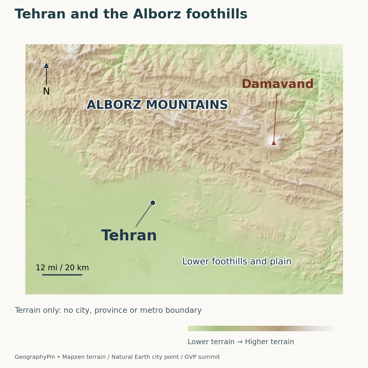
The relief map uses elevation data to show that transition. Its city marker is a location reference, not the point from which every published elevation or distance is measured. Mountain labels identify broad geographic features rather than surveyed administrative limits.
The two sides of the range also differ environmentally. NASA’s description of the Alborz contrasts the wetter Caspian-facing slopes with the dry country to the south. Tehran occupies the southern setting. Nearby high mountains therefore do not make the whole city a wet coastal environment, and snow on a ridge is not a measurement of water available to every district below.
For practical map reading, separate three layers: terrain height, the extent of buildings and the legal city boundary. A shaded-relief image answers the first question. A dated satellite image helps with the second. Neither, on its own, settles the third.
4. Tehran city, province and urban region are not interchangeable
A population figure needs a date and a defined area. The United Nations Statistics Division’s 2024 Demographic Yearbook lists 8,693,706 people for Tehran city proper, with a reference date of September 24, 2016. That is a historical census figure carried in a later publication, not a count of Tehran’s population in 2024 or today.
| Geographic unit | Figure or scope | How to interpret it |
|---|---|---|
| Tehran city proper | 8,693,706 people; September 24, 2016 | UN Demographic Yearbook 2024, Table 8; city-proper column |
| Tehran Province | A larger administrative unit containing the capital and other places | Do not substitute the city-proper figure for a provincial total |
| Urban agglomeration or metropolitan region | A wider urban or functional grouping, depending on the source | Check the stated boundary, method and reference year before comparison |
An urban agglomeration can include a city and adjacent densely settled territory outside its boundary. The UN explicitly distinguishes this from an individual locality. “Metropolitan area” may instead emphasize functional connections such as commuting, depending on the statistical system used. A province is an administrative geography, not another name for either concept.
This is why two Tehran population estimates can differ substantially without describing the same thing. First check the year, then the boundary, then whether the number comes from a census, a projection or another estimate. Only after those checks does a comparison become meaningful. For broader national context, use the separate Iran country profile rather than treating the capital as a miniature version of the whole country.
5. Mountain water, reservoirs and urban demand
Tehran’s relationship with the Alborz is not just visual. Water moves through mountain catchments and engineered supply systems before reaching urban users. NASA identifies Latyan Reservoir, east of Tehran, as one source delivering water to the capital. A reservoir serving the city need not lie inside the city boundary.
The older settlement pattern also depended on water moving through foothill deposits and on engineered channels. Encyclopaedia Iranica notes that Tehran lay between the major Karaj and Jajrud river systems rather than at the outlet of either. This is a useful correction to the idea that the capital simply grew beside one great river that naturally supplied everything it needed.
Growing demand can put pressure on both surface-water and groundwater resources. Satellite-radar research presented at ESA’s Fringe 2017 conference documented subsidence in parts of the Tehran plain in connection with groundwater depletion. Those findings concern particular surveyed areas and periods; they do not mean that every street in the capital sinks at one uniform rate.
The geographic lesson is the link between a city and its wider water system. Mountain snow, reservoirs, aquifers, distribution networks and consumption are related, but they are not interchangeable measures. A snowy photograph alone cannot establish reservoir storage or the reliability of urban supply.
6. What urban growth changes
NASA’s Landsat comparison of Tehran in 1985 and 2009 shows extensive urban expansion and additional roads. It is a dated record of growth, not a current street map. The comparison helps explain how an urban footprint can spread beyond the compact center that gave a city its original name.
Growth also changes how terrain is experienced. More buildings and transport links can connect formerly separate settlements, yet slopes, mountain valleys and drainage still influence where infrastructure can go. The useful question is not simply whether the city is large, but which geographic area a map or statistic actually represents.
Air quality supplies another example of the interaction between people and setting. NASA explains that winter temperature inversions can hold cooler, polluted air beneath warmer air, while the surrounding mountains restrict dispersal. Terrain affects the movement of air; it does not create vehicle emissions. A landscape explanation should therefore include both the physical setting and the human sources of pollution, rather than blaming mountains alone.
Frequently Asked Questions
Are Tehran and Teheran different cities?
No. Teheran is an alternative English spelling of Tehran. UNESCO uses that spelling in its Golestan Palace description. The difference is in how the name is rendered, not the location of a second Iranian capital.
What Did We Learn Today?
Tehran is Iran’s capital on the southern side of the Alborz, not a Caspian coastal city. Its political importance developed under the Qajars, while its foothill setting shapes water connections, terrain and urban expansion. City proper, province and metropolitan region answer different geographic questions, so population figures need matching boundaries and dates. Reading Tehran well means putting the mountain landscape, the historical city and the wider urban system on separate but connected layers.
Sources & Data Notes
The population is the September 24, 2016 city-proper census figure reported in the UN’s 2024 yearbook, not a current population estimate. Historical satellite comparisons and subsidence findings retain their study dates. The capital chronology follows the explicitly named historical reference rather than implying that the city’s development occurred on one day.
- UN Demographic Yearbook 2024: Table 8, city-proper population
- UN Statistics Division: locality and urban-agglomeration definitions
- Encyclopaedia Iranica: Iranian capital cities
- Encyclopaedia Iranica: Tehran at the foot of the Alborz
- UNESCO: Golestan Palace
- NASA: Tehran urbanization, 1985–2009 imagery
- NASA: Alborz setting and Latyan water connection
- NASA: Tehran smog and winter inversions
- ESA Fringe 2017: Tehran-plain subsidence research abstracts
Maps: original GeographyPin renderings using Natural Earth public-domain country and populated-place geometry, actual Mapzen terrain tiles, and the Smithsonian GVP Damavand location. Global SRTM and GMTED2010 terrain data are courtesy of USGS; global ETOPO1 data are from NOAA. See terrain attribution. North-up Web Mercator views use different scales; the detail scale bar is calibrated at its latitude. Terrain shading is generalized, not a surveyed summit measurement, land-cover layer or city boundary.
Featured photograph: Tehran skyline viewed from Tabiat Bridge, with the Alborz in the background, Mhsheikholeslami, April 1, 2015, CC BY-SA 4.0. Resized and converted to WebP; the adapted image remains available under the same license.