A country selector may put Svalbard and Jan Mayen on one line, but a physical map separates them immediately. One is a High Arctic archipelago; the other is an isolated volcanic island farther southwest. Reading the shared label as a single island group hides both their landscapes and their different institutions.
Svalbard and Jan Mayen are distinct parts of the Kingdom of Norway sharing the ISO code SJ. Svalbard is a High Arctic archipelago containing Spitsbergen and other islands; Jan Mayen is a separate volcanic island dominated by Beerenberg. The grouped code does not create a sovereign country, one island group or a shared local administration.
How to use this article: Locate the separate locations, follow Svalbard’s landscapes, or compare Beerenberg’s landforms.
1. Put Two Separate Places on the Arctic Map
A locator, not a combined island group
Svalbard lies far north of mainland Norway. Jan Mayen lies southwest of Svalbard, between Iceland and Spitsbergen, near the meeting of the Norwegian and Greenland seas. Jan Mayen is closer to Greenland than to mainland Norway. These relationships are easier to understand on the true-position locator than on a pair of relocated insets.
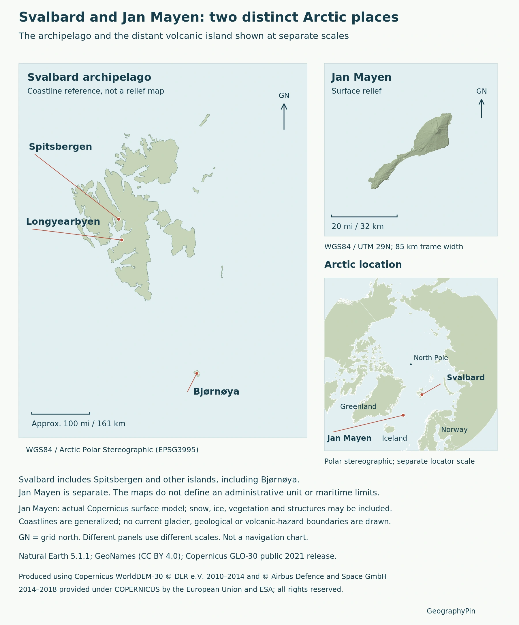
Use the detailed panels to inspect each coastline, then return to the locator to compare positions. Different panel scales must not be read as equal island sizes or as the distance between them. Longyearbyen is a settlement on Spitsbergen, not the name of the whole archipelago or a common capital for both territories.
The Norway country profile places both within the kingdom’s broader geography. Here the focus is their separate island settings, rather than Norway’s mainland fjords, national economy or country statistics.
2. Svalbard: More Than Spitsbergen
Islands, fjords and varied bedrock
Spitsbergen is Svalbard’s largest island, but it is not a synonym for the entire archipelago. Nordaustlandet, Edgeøya and Barentsøya form other substantial parts of the group. Outlying islands such as Bjørnøya and Hopen also belong in the geographic picture, even when a close-up of Longyearbyen leaves them outside its frame.
The landscape includes mountains, glacier-cut valleys, fjords, plateaus, tundra and low coastal wetlands. Bare uplands and greener valley floors can occur within the same archipelago. A photograph dominated by snow or sharp peaks therefore shows only part of its range of landforms.
Svalbard’s bedrock records many geological periods and contains abundant fossils. That long, varied geological history is a key contrast with a description centered on Jan Mayen’s volcanic cone. Ice has shaped Svalbard’s terrain, but the archipelago should not be imagined as a uniform volcanic island beneath a continuous white cover.
Its climate is High Arctic, moderated by Atlantic influence compared with many places at similar latitudes. This broad description does not make all islands, coasts and valleys climatically identical.
3. Jan Mayen: Beerenberg, Lava and Marine Erosion
An ice-covered volcano with a changing coastline
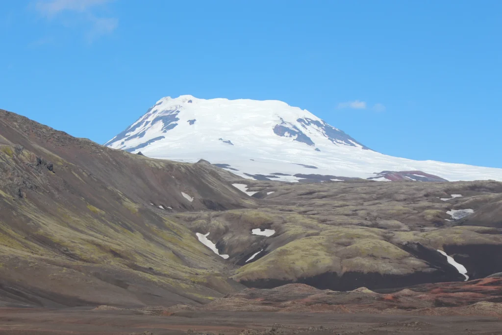
Beerenberg dominates Jan Mayen’s northern landscape. The Norwegian Polar Institute’s 2023 mapping report gives its height as about 7,454 feet (2,272 m), replacing the older 2,277 m figure. Because the summit is largely snow- and ice-covered, the revised mapped height should not be described simply as the bedrock sinking.
The same report documents eruptions in 1970 and 1985 that added new land. Waves subsequently removed part of the land formed in 1970. The island’s outline therefore reflects both volcanic construction and marine erosion, not only a cone rising above the sea. These are historical events, not a statement that an eruption is occurring now.
Rock and sand dominate much of the lower landscape, with mosses, lichens and grasses and richer herb growth near seabird colonies. SEAPOP describes a maritime transition between Arctic and boreal conditions: cool summers, comparatively mild winters and frequent fog. Beerenberg’s ice and the surrounding ocean help create a setting quite unlike a warm-climate volcanic island.
The featured photograph shows Beerenberg in August 2014. It illustrates Jan Mayen, not Svalbard, and its visible snow and ice belong to that photographed scene.
4. Shared Norwegian Sovereignty, Different Institutions
Norway’s foreign ministry distinguishes the Svalbard Act of 1925 from the Jan Mayen Act of 1930. Both territories form part of the Kingdom of Norway, but they have distinct legal arrangements. A rule applying on the mainland should not automatically be assumed to apply identically in either place.
The Svalbard Treaty recognizes Norwegian sovereignty; it does not divide ownership among the treaty parties. Signed on February 9, 1920 and effective from August 14, 1925, it includes equal-treatment obligations in specified fields, together with taxation and military-activity restrictions. Those conditions qualify Norway’s exercise of authority without creating an independent or jointly governed country.
The Governor of Svalbard represents the Norwegian state and performs police and regional administrative functions. Longyearbyen Community Council has a narrower jurisdiction within the Longyearbyen planning area. The council is not an all-Svalbard government, and neither institution supplies a shared local administration for Jan Mayen.
Jan Mayen’s station is staffed on rotating assignments. The Norwegian Armed Forces describes work supporting weather observations, satellite navigation and seismic monitoring, alongside the practical work of maintaining an isolated station. This is a different settlement pattern from Longyearbyen’s local community, not a second town under the same council.
5. What the Shared SJ Code Actually Means
The UN Statistics Division lists “Svalbard and Jan Mayen Islands” together, with M49 number 744, ISO alpha-2 code SJ and alpha-3 code SJM. Its table covers countries or areas. Inclusion is therefore not proof of sovereign statehood, and a database entry does not establish a common local government.
For a geographical comparison, keep three levels separate: Norway is the sovereign state; Svalbard is an archipelago with its own legal framework; Jan Mayen is a distinct volcanic island. The grouped coding entry is useful for data systems, but it cannot substitute for those physical and institutional distinctions.
The world country atlas explains its sovereign-country roster separately. A place can have an international area code and still not be an additional country in that count.
What Did We Learn Today?
Svalbard and Jan Mayen share Norwegian sovereignty and a coding entry, not one island group or common local administration. Svalbard combines multiple islands, fjords and varied geological landscapes; Jan Mayen is dominated by Beerenberg and the interaction of lava, ice and ocean erosion. True-position maps and clearly labeled detail scales make the contrast visible.
Sources & Data Notes
Sources, dates and map conventions
Beerenberg’s height follows the Norwegian Polar Institute’s 2023 mapping report rather than older 2,277 m references. Stable Svalbard landforms are supported by Norway’s 2007 tentative UNESCO submission; this is not a claim of World Heritage inscription. The paired profile does not combine settlement counts or station staffing into a population total.
- UN Statistics Division: M49 table and ISO area codes
- Norway: Svalbard white paper 2024, treaty and institutions
- Norwegian foreign ministry: territorial application of legislation
- Norway: Svalbard white paper 2016, stable island geography
- Norway’s 2007 UNESCO tentative submission: Svalbard landforms
- SEAPOP: Jan Mayen location, landscape and maritime climate
- Norwegian Polar Institute: Jan Mayen mapping, January 2023
- Norwegian Armed Forces: Jan Mayen station functions
Featured photograph: Beerenberg on Jan Mayen, Ryj-ak, August 18, 2014; CC BY-SA 4.0. Resized and converted to WebP without cropping; the adapted photograph retains this license.

Original GeographyPin map using Natural Earth 5.1.1, public domain, for Svalbard coastlines and the Arctic locator; GeoNames references, CC BY 4.0; and Copernicus GLO-30 public 2021 release for Jan Mayen only. Separate scales; no current glacier limits. Surface relief includes snow, ice and structures.
Produced using Copernicus WorldDEM-30 © DLR e.V. 2010-2014 and © Airbus Defence and Space GmbH 2014-2018 provided under COPERNICUS by the European Union and ESA; all rights reserved. Data license. The organisations in charge of the Copernicus programme by law or by delegation do not incur any liability for any use of the Copernicus WorldDEM-30.