The Snake River rises in Yellowstone, but it does not drain Yellowstone Lake. Its channel crosses Wyoming and southern Idaho, becomes a state line through Hells Canyon and finally reaches the Columbia in inland Washington.
The Snake River starts on Yellowstone’s Two Ocean Plateau and flows south into Jackson Lake. It crosses southern Idaho, turns north along the Oregon border through Hells Canyon and then runs west across southeastern Washington. It joins the Columbia River at Pasco, near the tip of Sacajawea Historical State Park.
How to use this article: Use the channel and basin map, compare Yellowstone’s two drainage directions, then locate the switch from Oregon to Washington and the Snake–Columbia confluence.
Source, mouth and the drainage basin
The Snake begins on Yellowstone’s Two Ocean Plateau, follows the valley of Jackson Hole, bends west across southern Idaho and then heads north through Hells Canyon. It does not return to Wyoming or cross the Cascade Range under its own name. The named channel ends at the Columbia in southeastern Washington.
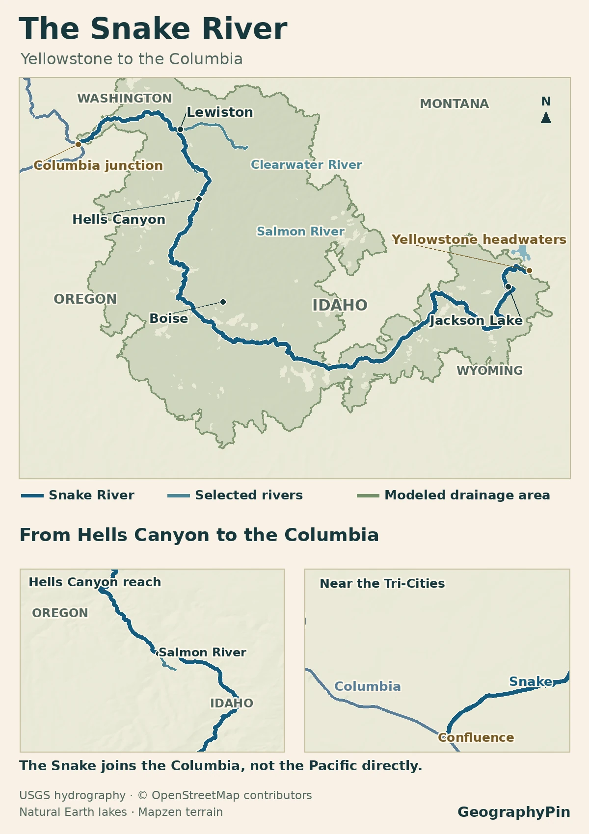
Trace the channel and its basin separately
The National Park Service gives the river’s length as about 1,040 miles (1,674 km) from Yellowstone to the Columbia. The outline shows land draining toward the Snake, not the full Columbia basin. The three USGS subregions (Upper, Middle and Lower Snake) add to about 107,500 square miles (278,000 km²) using the tabulated, rounded areas in its hydrologic-unit reference. That is a mapping convention, not a direct measure of runoff.
From Yellowstone headwaters to the Snake River Plain
Find the divide, not the lake
The park’s mapped headwater is about 3 miles (5 km) north of Phelps Pass near the Continental Divide. Yellowstone Lake is nearby on a regional map, but its outlet runs north down the Yellowstone River and eventually reaches the Missouri. The Snake flows the other way, into Jackson Lake in Grand Teton National Park. Jackson Lake is natural; a dam raises it and regulates the downstream outlet.
After the river leaves the mountains, it passes through Palisades Reservoir. In eastern Idaho the stretch below Palisades Dam is known as the South Fork; Henrys Fork meets it near Menan. Downstream from that junction the Snake passes Idaho Falls, then swings across the southern part of the Snake River Plain toward Twin Falls and western Idaho.
Hells Canyon and the Oregon–Idaho border
Find where the river stops bordering Oregon
The Snake meets the Oregon–Idaho line near the mouth of the Owyhee River. It follows the line northward, including through Hells Canyon, with Oregon to the west and Idaho to the east. State maps show the river leaving Oregon near China Garden Creek. It then separates Washington from Idaho until the Clearwater junction at Lewiston, Idaho, and Clarkston, Washington. Below the junction both sides are in Washington.
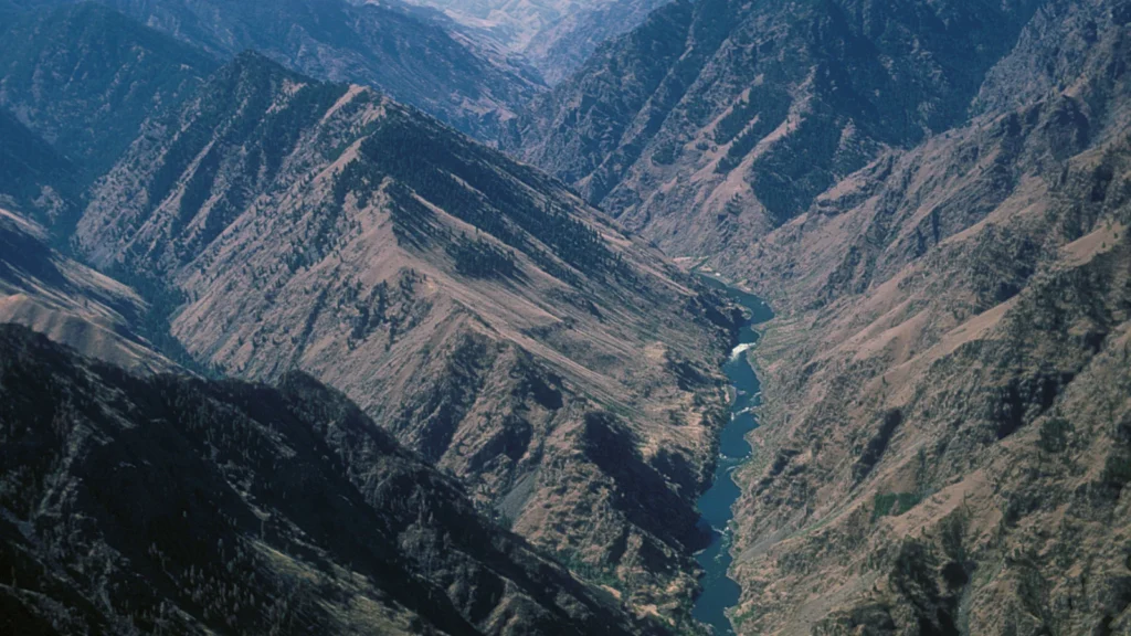
Hells Canyon records more than one chapter of the river’s course. A 2025 study dated rapid cutting of the canyon to about 2.1 million years ago, with a large dating uncertainty. Later research found sediment evidence for a waterway linking the western Snake River Plain and the Columbia basin more than 6 million years ago. The earlier link may not have been continuous; the date for rapid gorge cutting does not date the first connection.
Where the Snake meets the Columbia in Washington
Locate the park at the river mouth
The Snake runs west from Lewiston and Clarkston through the lower river’s reservoirs. The Army Corps lists four lower Snake dams in this Washington reach, from Lower Granite upstream to Ice Harbor downstream. Follow the channel below Ice Harbor to the tip of Sacajawea Historical State Park at Pasco. The Snake joins the Columbia beside the park, well inland. The Columbia then carries the combined water to its own Pacific outlet beside Cape Disappointment, with Oregon opposite.
Discharge can look very different at the same point at different times. The historical USGS record for Ice Harbor (station 13353000) lists a daily mean of 305,000 cubic feet per second (8,640 m³/s) on June 19, 1974. Its separate maximum value for that day was 312,000 cubic feet per second (8,835 m³/s). These are records below one dam, not at the confluence or a forecast.
The basin extends well beyond the river line
The Salmon River brings water out of central Idaho into the Snake below Hells Canyon Dam. The Clearwater, another major tributary, arrives at Lewiston. Both spread far east of the Snake on a basin map. The Idaho–Oregon line marks a state boundary along the gorge; it does not keep water on either side from reaching the same river.
Not all the water entering the mainstem follows a blue tributary line. USGS field studies in 2001–02 found that the Snake gained water from the aquifer in the Thousand Springs reach near Twin Falls, while a reach near Heise lost water. A surface drainage map shows where the ground slopes, not how much groundwater is moving underneath it.
Frequently Asked Questions
Which river from Yellowstone’s Shoshone Lake belongs to the Snake system?
The Lewis River. It carries water from Shoshone Lake through Lewis Lake and eventually joins the Snake. That makes Shoshone a lake in the Snake’s watershed, not the mapped source on Two Ocean Plateau.
Does an Ice Harbor gauge reading describe the same conditions near Jackson Lake?
No. The Ice Harbor figure reflects a much larger upstream drainage area and many tributaries, reservoirs and diversions between the two places. Use a station on the particular reach you are comparing, and match the dates and measurement intervals.
Why does the confluence at Pasco look broad like a lake?
It lies within the Columbia’s McNary Dam pool, Lake Wallula. The Snake and Columbia still have identifiable channels as they approach the junction, but the impoundment widens the water around it.
What Did We Learn Today?
The Snake begins in Yellowstone, runs through Jackson Lake and southern Idaho, then divides states along part of its northward course. It ends at Pasco, where the Columbia takes over. On the map, the Snake’s line marks that route; the wider basin shows where its water comes from.
Sources & Data Notes
The National Park Service locates the Two Ocean Plateau source and reports the river’s length and Jackson Lake connection. Idaho Fish and Game identifies the forks at Menan. The Oregon Revised Statutes, Idaho DEQ map description and Idaho attorney general’s boundary opinion anchor the state-border discussion. USGS describes the rapid canyon incision and older drainage evidence. Washington State Parks maps the Pasco confluence and identifies the Columbia’s ocean outlet.
Historic flows and station location are from USGS station report 13353000, based on Army Corps records; metric equivalents are rounded. Basin area is the sum of rounded USGS subregional entries 1704–1706. The USGS groundwater study and Army Corps lower Snake overview concern different river reaches. The Corps also describes Lake Wallula’s extent.
Featured photograph: Aerial View of Hell’s Canyon, Wallowa Whitman National Forest, Tom Iraci, U.S. Forest Service Pacific Northwest Region, October 4, 2005 (catalog date); U.S. public domain. Cropped, resized and converted to WebP.
Prepared for final factual and editorial review by Zurab Koniashvili (Z.K. Atlas). AI tools assisted with editorial preparation.
Map: GeographyPin. OpenStreetMap Snake River and Columbia River, accessed November 20, 2026, ODbL and credits. Selected exact Snake path runs through 264 recorded main-stream ways, no synthesized links; it shares OSM node 263291942 with both selected adjoining Columbia ways. Only selected Columbia context near this map shown, not its full route. The Yellowstone pin marks the upstream end of the mapped named line, not a surveyed spring or a location in Yellowstone Lake. Yellowstone National Park independently names the Two Ocean Plateau headwaters. Shaded USGS NLDI is the modeled basin at downstream NHDPlus reach 947060532; no area value derived for publication or claim of an exact legal boundary. Selected Salmon and Clearwater branches use USGS NLDI/NHDPlus, with 12 and 131 zero-gap reaches respectively; model and OSM confluence positions may differ slightly. Hells Canyon labels a river reach, not an exact legal or recreational extent. Lakes via Natural Earth, public domain; relief via Mapzen/AWS Terrain Tiles. No navigation or current access data.