Santa Fe’s mountain backdrop is more than scenery. Higher country supplies runoff, influences local conditions and helps explain why a city associated with dry Southwestern landscapes can also experience snow and freezing winters. Its setting becomes clearer when the city, nearby summits and the Rio Grande are placed on the same map.
Santa Fe is New Mexico’s capital in the north-central part of the state, at roughly 7,000 feet (2,130 m) above sea level. It lies beside the southern Sangre de Cristo Mountains, east of the Rio Grande. The Santa Fe River connects its mountain watershed, urban corridor and downstream Rio Grande basin.
Read Santa Fe in three layers: Start with the mountain setting, follow city and summit elevations, then compare the river downstream.
1. Where is Santa Fe, New Mexico?
A highland city beside the Southern Rockies
Santa Fe occupies the transition between mountain foothills and lower basin country in northern New Mexico. The Sangre de Cristo Mountains rise east and northeast of the city. They belong to the Southern Rocky Mountains, rather than to a separate range unrelated to the Rockies.
The Rio Grande lies west of Santa Fe, not through the downtown center. The smaller Santa Fe River is the watercourse associated with the city itself. Keeping the two rivers separate is essential: being part of the Rio Grande drainage basin does not mean the city sits on the banks of the main river.
City, county and watershed are different areas
This article focuses on the city’s physical setting. Santa Fe County extends well beyond the urban area, while the Santa Fe River watershed follows drainage divides rather than municipal boundaries. A summit described as being in Santa Fe County is not necessarily inside the city, and a water-supply catchment is not the same thing as the complete river basin.
The name also needs its state qualifier. This is Santa Fe, New Mexico, in the United States, not the Argentine city or the Santa Fe district of Mexico City. The map below locates the New Mexico city within its surrounding terrain.
2. Read the mountain and river locator
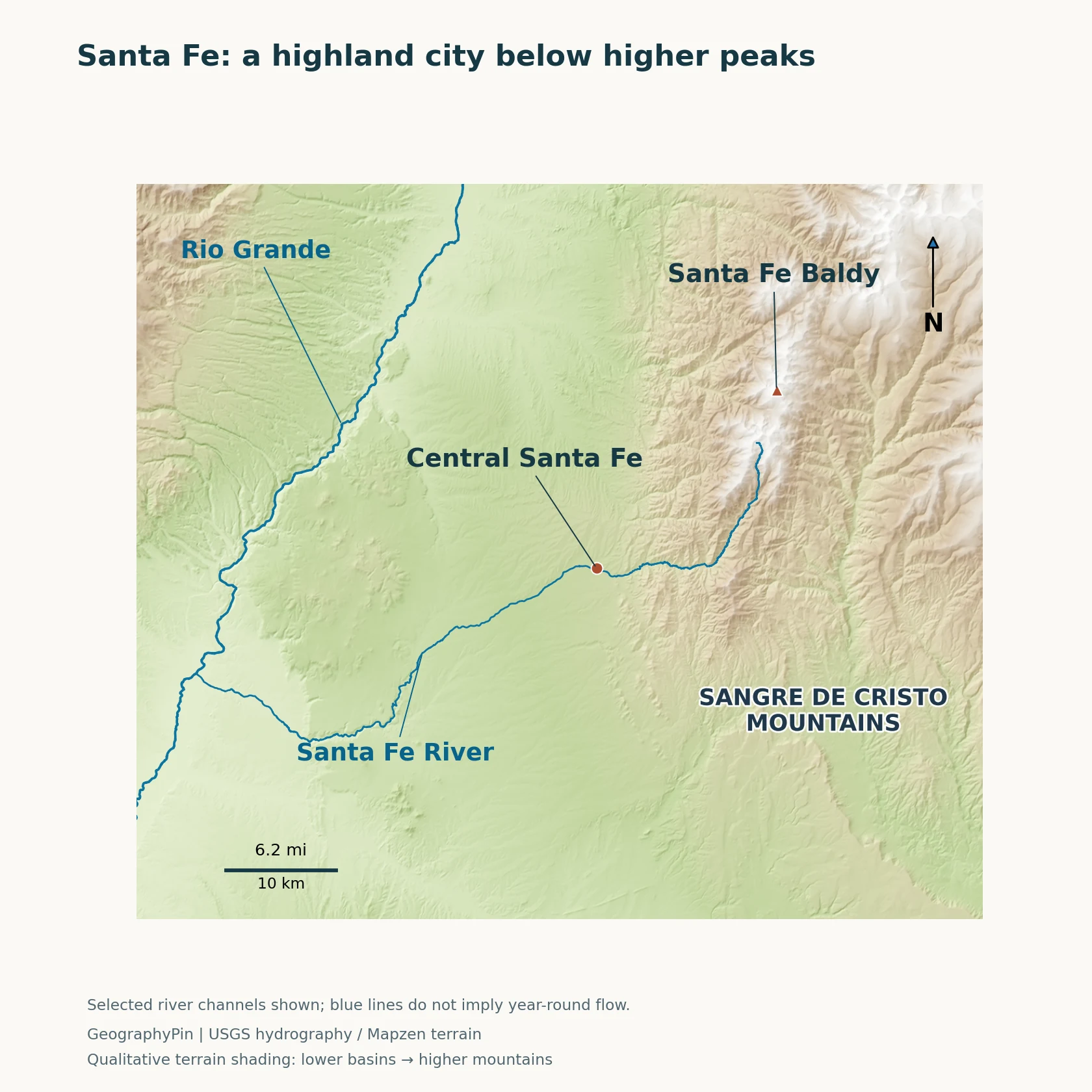
Start with central Santa Fe, then look northeast toward Santa Fe Baldy and west toward the Rio Grande. The terrain rises into the mountain range rather than forming a single flat platform at the city’s commonly quoted elevation. The river lines show drainage relationships; they do not guarantee that water flows continuously along every reach.
Why the mountains and basin sit together
The New Mexico Bureau of Geology places the Santa Fe Range beside the Española Basin on its western side. That basin belongs to the wider Rio Grande rift setting. A rift is a region where the continental crust has been stretched, producing an arrangement of basins, faults and surrounding uplands.
The local landscape has a much longer history than that one episode. Ancient crystalline rocks form part of the mountain core, and multiple phases of mountain building, erosion and later crustal extension shaped the region. The bureau notes that details of how the Santa Fe Range acquired its present relief remain subjects of research. It is therefore better to explain the broad basin-and-range relationship than to attribute every visible ridge to one simple fault movement.
The map’s points identify different things
The central-city marker is an orientation point near the Plaza, not a measurement representing every street. The Santa Fe Baldy marker identifies a nearby mountain summit. A general city elevation and a summit elevation answer different questions and should never be substituted for each other.
Relief shading comes from elevation data and is useful for seeing the shape of the landscape. It is not a geological map: a color on the terrain image does not identify a particular rock formation. Nor is the city marker an outline of Santa Fe’s administrative limits.
3. Elevation explains the setting, but not every weather detail
About 7,000 feet is a city reference, not a level surface
The EPA describes Santa Fe at approximately 7,000 feet (2,130 m). This is a useful broad reference for the city’s highland position. Actual elevations change across its streets, neighborhoods and surrounding slopes, so an airport, weather station or hilltop may have a different figure without either measurement being wrong.
Santa Fe Baldy stands at roughly 12,600 feet (3,840 m), substantially higher than the city. Santa Fe County’s Open Land and Trails Plan lists the traditional summit figure as 12,622 feet (3,847 m). The rounded comparison is the important point here: conditions in high mountain terrain cannot be inferred directly from conditions downtown.
Digital terrain grids also have limits. A grid cell averages or samples a small area, and it may miss the highest rock of a narrow summit. The map uses the terrain model to show relief, while the published elevation references describe their stated city or summit contexts. They are not interchangeable precision surveys.
A dry setting can have cold winters and summer storms
For a concrete climate example, NOAA’s 1991–2020 normals for the Santa Fe 2 station give a January average daily high of 43.0°F (6.1°C) and low of 17.9°F (−7.8°C). In July, the corresponding averages are 85.8°F (29.9°C) and 55.1°F (12.8°C). These are station averages over thirty years, not a forecast or temperatures for nearby summits.
The station’s listed elevation is 6,756 feet (2,059 m), another reason to identify the observation location instead of attaching every number to an undifferentiated “Santa Fe.” The contrast between warm summer days, cooler nights and freezing winter conditions is more informative than assuming all Southwestern cities have the same climate.
Summer precipitation is influenced by the North American monsoon, when seasonal circulation brings more moisture into the Southwest and thunderstorms become important. The National Weather Service emphasizes wet bursts separated by drier breaks. That pattern does not promise rain every afternoon, and one season’s rainfall does not tell you what the next will bring.
4. The Santa Fe River connects mountains, reservoirs and the city
Follow the water downstream
The Santa Fe River begins at Santa Fe Lake in the high country east of the city, below Lake Peak. That headwater setting is distinct from Santa Fe Baldy, the summit used for comparison on this page. The river then reaches McClure Reservoir and, farther downstream, Nichols Reservoir before continuing toward the city.
The city describes the complete river course as about 46 miles (74 km) to its confluence with the Rio Grande. The upper municipal watershed is only part of that larger drainage area. Forested headwaters, the urban river corridor and the lower river should not be pictured as identical environments.
The river through Santa Fe is also managed. The city’s Living River program makes releases to support the middle river corridor, with the amount depending on reservoir storage and expected runoff. Sections can be dry for much of a typical year. A blue line on a locator map therefore marks the river’s course, not a promise of continuous surface flow.
Drinking water comes from more than one source
Santa Fe’s water system combines local surface water, groundwater and surface water diverted from the Rio Grande. The city’s sustainability dashboard identifies snowmelt from the Sangre de Cristo Mountains as important to the Santa Fe River supply. The mix connects the urban area to both nearby mountain catchments and a wider regional water system.
Forest management is consequently part of water management. The city uses vegetation treatment and prescribed fire in its municipal watershed to reduce the risk of damaging wildfire and protect water supplies. The protected municipal watershed is not simply another unrestricted recreation area; its management purpose is different from that of a typical urban park.
5. Settlement in a dry highland landscape
The Santa Fe River has supported drinking water, irrigation, habitat and cultural needs over a long period of human settlement. Modern infrastructure has changed how water is stored and distributed, but it has not removed the connection between the city and its surrounding land.
Water conservation, stormwater planning and catchment protection address different parts of that connection. Conserving supplied water reduces demand; managing runoff helps deal with water moving across developed surfaces; protecting upstream land helps safeguard source water. These are complementary tasks, not alternative names for the same process.
That is why Santa Fe is a useful example of physical geography shaping a city. Elevation and drainage do not determine every aspect of urban life, but they establish conditions that development must work with. The surrounding landscape supplies resources while also requiring attention to variable rainfall, snowmelt and changing river flow.
6. Key facts and measurement notes
| Feature | Meaning |
|---|---|
| Location | North-central New Mexico, United States; near the southern Sangre de Cristo Mountains. |
| City elevation reference | Approximately 7,000 feet (2,130 m), a broad reference rather than an elevation for every neighborhood. |
| Nearby summit comparison | Santa Fe Baldy: roughly 12,600 feet (3,840 m); county plan’s traditional figure is 12,622 feet (3,847 m). |
| City river | Santa Fe River, which drains toward the Rio Grande west of the city. |
| Climate example | Santa Fe 2 station, NOAA 1991–2020 normals; not summit or citywide observations. |
| Map interpretation | City and summit locators over terrain data, not municipal boundaries, hiking routes or guaranteed flowing-water reaches. |
Frequently Asked Questions
Is Santa Fe in the Rocky Mountains?
Santa Fe lies beside the southern Sangre de Cristo Mountains, which form part of the Southern Rockies. The city occupies a lower foothill-and-basin setting than the nearby high summits.
Does the Rio Grande flow through downtown Santa Fe?
No. The Rio Grande is west of the city. The Santa Fe River runs through the urban area and is a tributary of the larger Rio Grande system.
What Did We Learn Today?
Santa Fe’s geography is defined by relationships between a high-elevation city, still higher mountains and a river system draining toward the Rio Grande. A city elevation is not a summit measurement, a station climate average is not a mountain forecast, and a mapped river is not necessarily flowing continuously. Reading those distinctions together explains how the city’s dry highland setting, water supply and surrounding terrain fit together.
Sources & Data Notes
City and summit elevations are different reference contexts. The summit comparison is rounded; the traditional 12,622-foot value comes from the county’s 2000 plan, not a new survey. NOAA climate figures refer specifically to Santa Fe 2 (USC00298085), 1991–2020 normals, at a listed station elevation of 6,756 feet. Metric equivalents are rounded. No population estimate or municipal boundary is inferred from the relief map.
- EPA: Santa Fe geographic setting and stormwater planning.
- New Mexico Bureau of Geology: Santa Fe Range and regional geologic history.
- Santa Fe County: Open Land and Trails Plan, 2000, printed page 3, summit reference.
- NOAA: Santa Fe 2 monthly climate normals; National Weather Service: North American monsoon.
- City of Santa Fe: river and Living River program; municipal watershed management; water-supply sources.
Map: GeographyPin cartography. The central locator is near the Plaza; the Baldy locator follows the USGS Concise Gazetteer. Terrain uses Mapzen Terrain Tiles via AWS; river geometry uses the USGS National Hydrography Dataset. Terrain colors illustrate relief, not geological formations. River channels are selected source geometry, not a complete drainage network. Terrain source attribution includes USGS and NASA SRTM data. Digital elevation grids can undersample narrow summits; the map does not present a new surveyed summit height.
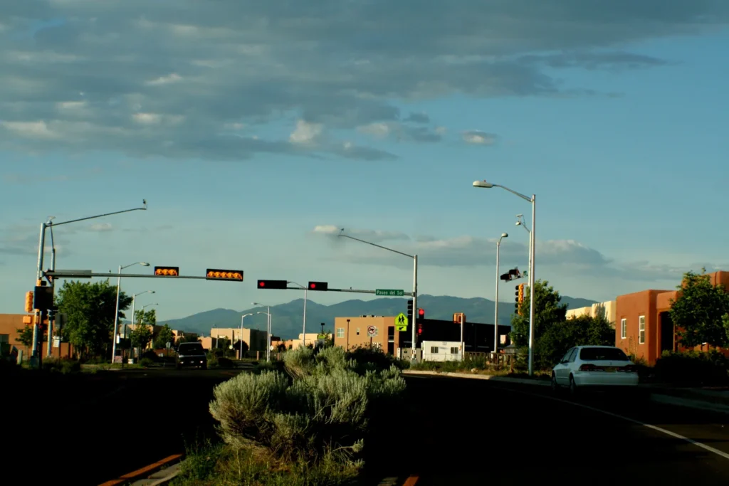
Featured photograph: Asaavedra32, “Santa Fe Street Sangre de Cristo”, 2007, CC BY-SA 3.0. Resized and converted to WebP; the image remains under that license.