A map of western Iberia shows only part of Portugal. The country also extends into the Atlantic through the Azores and Madeira, where volcanic islands have different landscapes from the mainland’s river valleys and uplands. Understanding those three settings helps explain Portugal’s territory, climate and connections without treating its islands as an afterthought.
Portugal includes an Atlantic-facing mainland beside Spain and two autonomous island regions: the Azores and Madeira. Lisbon is the national capital. The mainland’s mountains, plains and international river valleys contrast with the islands’ volcanic relief. Separate map insets make these distant places readable, but do not mean they lie beside the mainland or at the same scale.
How to use this article: Compare the mainland and islands, distinguish national and mainland high points, or follow rivers shared with Spain.
1. Locate mainland Portugal and its Atlantic islands
Mainland Portugal occupies the western side of the Iberian Peninsula. Spain is its only land neighbor; the Atlantic borders the west and south. Its southern Algarve coast is therefore Atlantic, even though much of the country has a Mediterranean-type climate. A climate label and the name of an adjoining sea are different things.
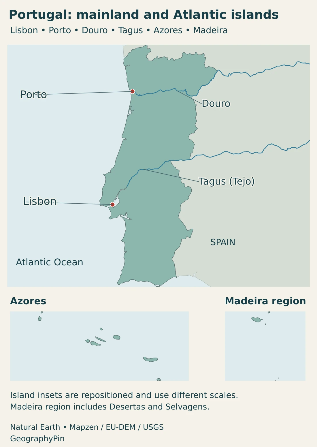
The Azores lie farther west in the North Atlantic, while Madeira lies southwest of mainland Portugal, off northwestern Africa. Both are parts of Portugal, not separate sovereign countries. Their autonomous status concerns government within the Portuguese state; their oceanic locations concern geography.
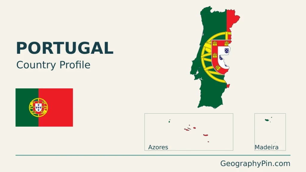
A regional map of Europe provides the mainland context, but a national map also needs the islands. On this page, the inset labels explain scale and placement. The empty ocean between the groups is real: moving an archipelago into a compact frame does not move it geographically closer to Lisbon.
2. Country facts, Lisbon and territorial scope
| Item | Detail |
|---|---|
| Capital | Lisbon (Lisboa) |
| Population | 11,424,031 residents on December 31, 2025; INE annual estimate using administrative data. |
| National area | About 35,608 sq mi (92,225.21 km²), DGT CAOP2025 administrative area, including the Azores and Madeira. |
| Mainland component | About 34,403 sq mi (89,102.14 km²), in the same DGT release. |
| Island-region components | Azores: about 897 sq mi (2,321.96 km²); Madeira: about 309 sq mi (801.10 km²). |
| Government | Semi-presidential republic; a unitary state with two autonomous island regions. |
| Official language | Portuguese |
| Currency | Euro (€) |
| Municipalities | 308 in DGT CAOP2025. |
Population: INE. Area and municipalities: DGT CAOP2025, released in 2026. Area is calculated from the administrative geographic database, not the country’s exclusive economic zone or a separate dry-land-only series. Square-mile values are rounded; the independently rounded component areas differ from the published national total by 0.01 km².
A national population total is not the population of mainland Portugal alone, nor a count of Portuguese citizens worldwide. Residents, citizens and the Portuguese diaspora are different groups. The estimate’s reference date also differs from its publication date, so a release published in 2026 need not describe the population in 2026.
Lisbon is the national capital, appearing in the country-and-capital reference as Portugal’s capital city. Lisbon municipality, its continuous urban area and a wider metropolitan region are not interchangeable boundaries. The same distinction matters when comparing Porto with the country’s other urban places.
The Constitution identifies the mainland, Azores and Madeira as Portuguese territory. It also establishes the Azores and Madeira as autonomous regions with their own statutes and self-government institutions. Municipalities are a different level of administration; neither an island group nor a statistical region should be treated as just another municipality.
3. Mainland landscapes, Azores and Madeira
Compare the mainland and Atlantic archipelagos
| Setting | Landscape character | What the distinction explains |
|---|---|---|
| Northern and central mainland | Uplands and mountain country crossed by valleys, including the Douro | Elevation and inland distance produce contrasts with coastal lowlands. |
| Southern mainland | Broad lower landscapes alongside local hills, the lower Tagus region and the Algarve coast | The south is not one continuous plain, and Atlantic influence varies with location. |
| Azores | A dispersed Atlantic archipelago with volcanic islands | National territory includes oceanic landscapes far from Iberia. |
| Madeira | Volcanic island terrain, including steep slopes and deeply cut valleys | Relief creates strong local contrasts within a comparatively small island setting. |
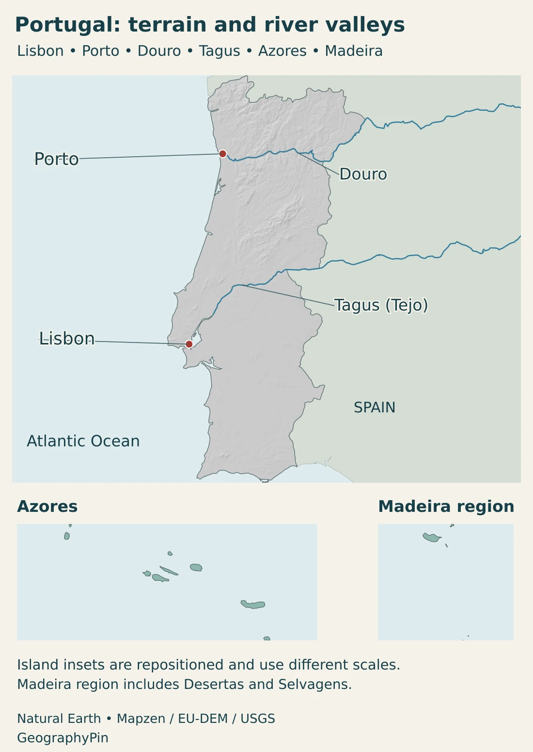
The mainland is not a single flat coastal strip. Northern and central uplands, river-cut valleys and lower southern landscapes give it an internal structure that a simple outline cannot show. Rivers connect inland territory with the Atlantic, while mountainous terrain separates neighboring valleys and influences routes between them.
The Azores are an archipelago rather than one island. São Miguel and Santa Maria form the eastern group; Terceira, Graciosa, São Jorge, Pico and Faial form the central group; Flores and Corvo form the western group. These nine principal islands are spread across the ocean, not arranged as a compact cluster beside the mainland.
Madeira is also both an island name and an archipelago name. The wider group includes Porto Santo, the Desertas and the Selvagens. Madeira island is the exposed part of a large volcanic edifice, with a mountainous interior cut by valleys. Its physical history differs from that of a continental river basin even though both belong to the same country.
Portugal’s highest point is not on the mainland
Pico Mountain in the Azores reaches 7,713 ft (2,351 m), making it Portugal’s highest point. The highest point on the mainland is in Serra da Estrela. Both statements can be correct because their territorial scope differs.
This distinction is more useful than treating the two elevations as competing answers. A mainland-only map leaves out the national high point, while a national profile needs to explain why an Atlantic island supplies it. Neither summit height describes the usual elevation of Portugal’s coastal cities.
4. Climate and rivers across national borders
Much of mainland Portugal has a temperate, dry-summer climate. The Atlantic moderates coastal conditions, while inland areas can have greater seasonal contrasts. IPMA’s climate classification distinguishes hotter-summer and milder-summer settings rather than assigning every part of the country the same conditions.
Elevation adds another layer: a coastal town and a high mountain location do not have identical weather. The islands also vary. IPMA distinguishes climate types within the Azores, and Madeira’s mountainous relief creates local contrasts. Broad climate descriptions are not forecasts for a particular trip or evidence that every island is warm and dry throughout the year.
The Douro and Tagus connect Portugal with Spain
The Douro rises in Spain, follows part of the international border and crosses northern Portugal before reaching the Atlantic at Porto. In Spanish it is called the Duero. These are names for the same river, not two separate watercourses.
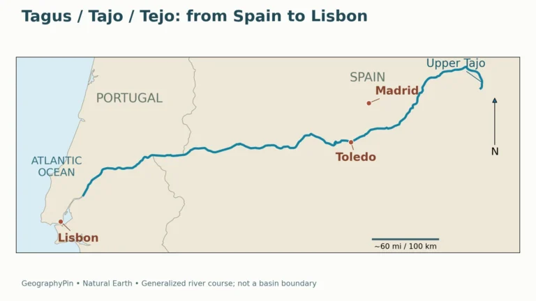
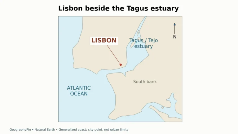
The Tagus, known as the Tejo in Portuguese and Tajo in Spanish, also begins in Spain and crosses into Portugal. Its lower course and estuary are central to Lisbon’s geographic setting. The Guadiana is another major shared system farther south, including stretches of the Portugal–Spain boundary.
River management therefore cannot stop at the national border. Portugal and Spain cooperate through the Albufeira Convention framework, covering shared river basins. A basin includes the land draining toward a river and its tributaries; it is not simply the visible blue line on a map.
The river basin plans address water use, ecological conditions, drought and flooding. That combination matters in a dry-summer setting: a seasonal climate pattern does not guarantee sufficient water everywhere, and a wet episode does not eliminate longer-term water-management pressures. The relevant scale can be an entire cross-border catchment rather than one city or reservoir.
5. People, cities and languages
Lisbon and Porto are major urban centers associated with the Tagus and Douro respectively. Their river-mouth settings connect inland routes with the Atlantic, but their present urban regions extend beyond the historic centers. A city dot on the map marks location, not the boundary of a metropolitan population.
Portugal’s settlement pattern also includes smaller mainland towns and island communities. Living on an Atlantic island involves a different relationship with transport and distance from living beside a continuous land route. National membership does not remove the practical significance of the ocean separating the archipelagos from Iberia.
Portuguese is the official language under Article 11 of the Constitution. That national legal status does not imply that every resident has Portuguese as a first language. Nor does the worldwide use of Portuguese make other Portuguese-speaking countries part of Portugal: language connections and state sovereignty are separate matters.
Population comparisons need particular care with the latest INE estimate. The 2025 series uses integrated administrative records and indicators of residence. A difference from an older published total may reflect a change in statistical method as well as demographic events, so subtracting unrelated releases would not produce a reliable measure of growth.
6. Government and economic connections
Portugal is a semi-presidential republic, with a president as head of state and a prime minister as head of government. It has been an EU member since 1986 and a euro-area member since 1999. The Constitution combines a unitary state with autonomous island institutions, rather than defining the Azores and Madeira as sovereign states.
The Port of Sines illustrates the economic importance of the Atlantic frontage. Its deep-water terminals handle energy products, containers and other cargo. The connection is geographic as well as commercial: maritime access links with inland transport and industrial infrastructure, rather than ending at the beach.
In the Alto Douro, agriculture has reshaped steep terrain through vineyard terraces, retaining walls, paths and settlements. UNESCO recognizes this as a cultural landscape. The valley is not simply untouched scenery; its appearance records long interaction between slopes, water, cultivation and human labor.
Those examples show different ways of using place. A deep-water port connects international shipping with land-based activity, while a terraced agricultural region adapts cultivation to a difficult slope environment. Island communities add another setting, where ocean crossings and volcanic terrain shape connections. None of these examples alone represents the whole Portuguese economy.
Frequently Asked Questions
Are the Azores and Madeira part of Portugal?
Yes. They are autonomous regions within Portugal, not independent countries. Both lie in the Atlantic away from the mainland, which is why national maps often show them in separate insets.
Does Portugal have a Mediterranean coast?
No. Mainland Portugal’s coast faces the Atlantic. Mediterranean-type climate describes a seasonal climate pattern and does not mean that the coastline borders the Mediterranean Sea.
Why do sources give different highest mountains for Portugal?
Some refer only to the mainland, whose highest point is in Serra da Estrela. The national high point is Pico Mountain in the Azores, at 7,713 ft (2,351 m). Check the territorial scope before comparing answers.
What Did We Learn Today?
Portugal combines an Iberian mainland with two autonomous Atlantic island regions. Its national high point lies in the Azores, while the mainland’s major rivers connect it with Spain. Climate, coastline and political membership describe different kinds of geography: an Atlantic country can have a dry-summer climate, and distant islands can remain part of the same state. Clear territorial and statistical scope makes its maps and country facts easier to interpret.
Sources & Data Notes
- INE — Resident population estimates, 2025. July 2026 publication: 11,424,031 residents on December 31, 2025. The revised estimation method integrates administrative records and indicators of residence; this is not a 2026 census count.
- DGT — CAOP2025 area and administrative-unit tables. Official spreadsheet download: national area 92,225.21 km², mainland 89,102.14 km², Azores 2,321.96 km² and Madeira 801.10 km²; 308 municipalities. Areas are calculated from the CAOP geographic database using the stated mainland and island coordinate systems.
- Portuguese Parliament — Constitution. Articles 5–6 establish territorial and autonomous-region scope; Article 11 establishes Portuguese as the official language.
- European Union — Portugal. Capital, semi-presidential system, EU membership and euro-area dates. The population date and detailed areas above follow INE and DGT respectively.
- DGT — Spatial Planning and Regional Development in Portugal. 2021 geographic discussion of mainland relief, northern uplands and southern lowlands; not a source of current demographic figures.
- Turismo de Portugal — Portugal Identity Card. Mainland and archipelago locations, nine principal Azores islands and the mainland high point in Serra da Estrela. Country totals in the table use the newer statistical sources above.
- Turismo de Portugal — Pico, the mountain island. Pico Mountain’s 2,351 m national high point and volcanic island landscape.
- Madeira regional geodiversity service — Geological setting. The archipelago’s component island groups and Madeira’s volcanic construction and rugged relief.
- IPMA — Climate normals and classification. Dry-summer mainland classifications and variation between the island groups. Climate normals describe reference periods, not a local forecast.
- Albufeira Convention commission — Douro river-basin description. Douro’s source, international course and Porto estuary, and shared-basin geography.
- Diário da República — Resolution 62/2024. Approved river-basin plans for 2022–2027; Tagus and Guadiana geography, cross-border cooperation and water-management context.
- Ports of Sines and the Algarve Authority — Port of Sines. Deep-water port, specialized cargo terminals and inland industrial/logistics connections; no undated cargo ranking is used.
- UNESCO — Alto Douro Wine Region. Terraced cultivation and the relationship between valley slopes, vineyards, settlements and a working cultural landscape.
Map sources and scope: Original GeographyPin maps use public-domain Natural Earth land, populated-place coordinates and river geometry. All Portuguese components in that source are retained. Separate Lambert azimuthal equal-area frames show the mainland, Azores and Madeira region at different scales; the island panels are repositioned, not shown at their true distance or bearing from Lisbon.
The Madeira frame includes Porto Santo, Desertas and the source-mapped Selvagens. Tiny islands may be hard to resolve at screen size. The Douro and Tagus follow actual generalized source lines; these do not show every tributary or provide navigation information. City markers locate Lisbon and Porto rather than municipal or metropolitan boundaries. Generalized land boundaries are not a legal or cadastral delineation, and no maritime jurisdiction is mapped.
Mainland hillshade is calculated from real elevations accessed through Mapzen Terrain Tiles; island insets show outlines without relief. Produced using Copernicus data and information funded by the European Union, EU-DEM layers; global elevation data courtesy of the U.S. Geological Survey. Elevation-source attribution and terms apply. Hillshade depicts terrain form, not elevation classes or local navigation detail.
The cover uses the official-source Portuguese flag artwork in a decorative outline motif, with an intact flag beside it, a divider and GeographyPin branding.