Mount Vinson is Antarctica’s tallest peak at 16,050 feet (4,892 meters), located in the Sentinel Range of the Ellsworth Mountains, about 750–805 miles (1,200–1,300 kilometers) from the South Pole. First climbed in 1966, it is one of the Seven Summits and is famed for extreme cold, clear skies, and logistical complexity.
Where Is Mount Vinson? Antarctica’s High Point in Context
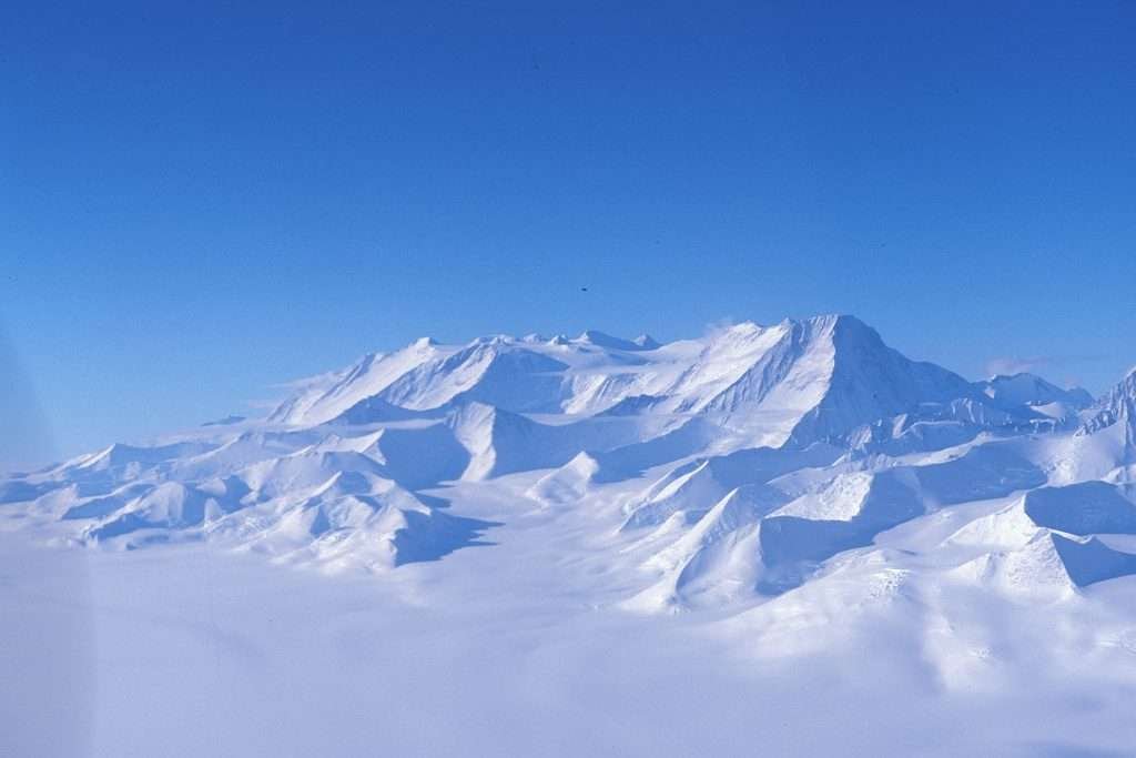
Mount Vinson crowns the southern Sentinel Range within the Ellsworth Mountains, overlooking the Ronne Ice Shelf. Its summit lies on the northern margin of the Vinson Plateau at approximately 78°31′32″S, 85°37′02″W. The mountain’s isolation is extraordinary: its topographic isolation is roughly 4,911 kilometers (3,051 miles), underscoring how far it stands from any higher ground on Earth.
Vinson sits near Branscomb Glacier, with Union Glacier Camp serving as the primary aviation hub for expeditions. From Union Glacier, ski aircraft ferry climbers about 95 miles (151 kilometers) to Vinson Base Camp on the Branscomb Glacier. This air link is the lifeline in a region without roads, ports, or permanent settlements.
Map Context & Nearby Features
The Sentinel Range forms the northern half of the Ellsworth Mountains, trending NNW–SSE for ~185 kilometers (115 miles). To the south lies the Heritage Range; Minnesota Glacier divides them. Vinson’s plateau neighbors peaks such as Mount Shinn and Silverstein Peak, with glaciers (Roché, Jacobsen) draining toward Branscomb Glacier.
| Metric | Value |
|---|---|
| Elevation | 16,050 ft (4,892 m) |
| Prominence | 16,050 ft (4,892 m) |
| Topographic Isolation | 3,051 mi (4,911 km) |
| Coordinates (approx.) | 78°31′32″S, 85°37′02″W |
| Distance from South Pole | ~750–805 mi (~1,200–1,300 km) |
| Range | Sentinel Range, Ellsworth Mountains |
| First Ascent | Dec 18, 1966 (Clinch-led American team) |
Key sources: National Geographic, Peakbagger, USGS/SCAR mapping, and ALE flight logistics.
Landscape & Geology of the Vinson Massif
Mount Vinson rises from the Vinson Plateau, a high ice-and-rock table between 13,100 and 15,100 feet (4,000–4,600 meters). The massif’s bedrock belongs to the Crashsite Group—thick packages of quartzose sandstones and argillites (now quartzites and shales) tilted steeply by ancient tectonics. These erosion-resistant rocks help create Vinson’s sharp ridges and towering faces.
USGS and later Omega Foundation GPS surveys refined Vinson’s modern elevation to 4,892 meters (16,046–16,050 feet), replacing earlier estimates above 5,000 meters. Fossils in nearby units record a long history from the Late Cambrian through the Devonian, making the massif a window into Antarctica’s deep past as continents assembled and broke apart.
How Old Are Vinson’s Rocks?
Crashsite Group strata include Late Cambrian fossils at the base and Devonian fossils higher up, indicating deposition hundreds of millions of years ago in shallow seas—long before today’s polar ice sheets existed.
Climbing Mount Vinson: Routes, Season & Logistics
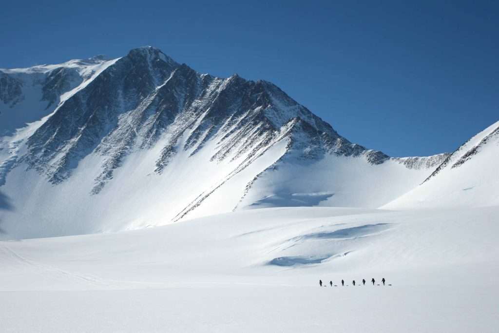
Most ascents follow the Branscomb Shoulder (also called the Branscomb Glacier route). After flying from Punta Arenas, Chile, to Union Glacier, climbers transfer by ski aircraft to Vinson Base Camp on the Branscomb Glacier. The climb typically runs November–January, when there is 24-hour daylight. Guiding companies stage the trip over 12–13 days, but weather can extend schedules.
From Base, the route trends up-glacier to Low Camp (~9,000 ft / 2,750 m), then climbs fixed ropes on 35–45° snow slopes to High Camp (~12,400 ft / 3,770–3,780 m). Summit day gains roughly 3,600 feet (1,100 meters) over exposed, frigid terrain, rewarding climbers with sweeping views across the Ellsworths and Ronne Ice Shelf. Strong glacier travel skills, cold-weather systems, and disciplined self-care are essential.
Standard Branscomb Shoulder Itinerary (Simplified)
Base → Low Camp: Pull sleds up the Branscomb Glacier; rope teams manage crevasse risk. Low → High Camp: 3,200–3,350 ft (1,000–1,020 m) gain on fixed lines up to ~45°, then traverse a wind-exposed plateau to camp. High Camp → Summit: A long, cold day with sustained sub-freezing air temperatures and potentially severe wind chill.
Helpful planning resources: National Geographic’s Mount Vinson overview; ALE’s Vinson Base Camp logistics.
Weather, Safety & Environmental Rules
Even in peak season, interior Antarctica is brutally cold and dry. At Vinson Base Camp, average mid-season temperatures range from about −12°F to 30°F (−24°C to −1°C), with early-season cold near −22°F (−30°C) and wind chills that can plunge to −40°F/°C. Clear skies often alternate with fast-moving, multi-day storms; flexible scheduling is part of safe decision-making.
All visits must follow the Protocol on Environmental Protection to the Antarctic Treaty and visitor guidelines coordinated by IAATO. Rules include rigorous waste removal (including human waste), biosecurity measures, wildlife distance rules, and environmental impact assessments for activities. Traveling with operators aligned to these standards helps protect Antarctica’s pristine environment. Read more via the Antarctic Treaty Secretariat’s Protocol page and IAATO’s visitor guidance.
History, Naming & Exploration
U.S. Navy aircraft first photographed the high peaks of the Sentinel Range in January 1958. The massif was named for U.S. Congressman Carl G. Vinson in 1961. On December 18, 1966, an American Antarctic Mountaineering Expedition led by Nicholas Clinch made the first ascent—an achievement that opened the door to modern Antarctic alpinism.
For years the highest point was informally called “Vinson Massif.” On November 1, 2006, the U.S. Advisory Committee on Antarctic Names formally distinguished Mount Vinson (the highest summit) from the larger Vinson Massif (the multi-summit block). Later GPS work refined the summit’s modern elevation to 4,892 meters (16,046–16,050 feet).
How Vinson Compares to the Seven Summits
Mount Vinson isn’t the tallest of the Seven Summits—that title belongs to Everest at 29,032 feet (8,849 meters). Vinson’s challenge is remoteness and weather, not technical difficulty. Access requires intercontinental flights, blue-ice runways, ski aircraft, and full expedition support. While Denali demands heavy carries at altitude, Vinson layers cold management, wind exposure, and logistics onto a moderately angled glacier climb.
Costs reflect the logistics: guided Vinson itineraries often exceed USD $50,000, covering Antarctic flights and camp infrastructure. For many climbers pursuing the Seven Summits, Vinson is attempted late in the sequence, after experience on high, cold peaks such as Denali or Aconcagua.
FAQ
How high is Mount Vinson and where is it?
Mount Vinson reaches 16,050 ft (4,892 m) in the Sentinel Range of the Ellsworth Mountains, West Antarctica, roughly 750–805 miles (1,200–1,300 km) from the South Pole.
When was Mount Vinson first climbed?
The first ascent was on December 18, 1966, by an American team led by Nicholas Clinch during the 1966–67 austral summer.
What’s the standard climbing route and season?
Most teams use the Branscomb Shoulder route: Base → Low Camp (~2,750 m / 9,000 ft) → High Camp (~3,780 m / 12,400 ft) → Summit. The season runs November–January with 24-hour daylight but severe cold and storms.
What environmental rules apply to Vinson expeditions?
All expeditions must follow the Antarctic Treaty’s Environmental Protocol and IAATO visitor guidelines: strict waste removal, biosecurity, wildlife distances, and impact assessments.
What Did We Learn Today?
- Mount Vinson is Antarctica’s highest point at 16,050 ft (4,892 m) on the Vinson Plateau.
- It lies ~750–805 mi (~1,200–1,300 km) from the South Pole, emphasizing extreme remoteness.
- The massif’s hard quartzites (Crashsite Group) shape its sharp ridges and high plateau.
- Climbers use the Branscomb Shoulder route with camps at ~2,750 m and ~3,780 m, often over 12–13 days.
- Strict environmental rules (ATS Protocol, IAATO) govern waste, wildlife, and biosecurity for all visitors.