Mexico’s coastline is easy to recognize, but it conceals a country organized around highlands, mountain rims and very different peninsulas. Reading its relief alongside its outline explains why a desert peninsula, a limestone groundwater landscape and a densely settled volcanic highland can belong to the same country.
Mexico is a North American country bordered by the United States, Guatemala and Belize. The Sierra Madre systems frame an interior plateau, while a volcanic belt crosses its central highlands. Baja California and Yucatán form contrasting peninsulas. Elevation, mountain exposure and rock structure help explain differences in climate, rivers and underground drainage.
How to use this article: Compare the mountain rims, explore Yucatán’s groundwater, or distinguish the country, capital and State of Mexico.
1. Where is Mexico?
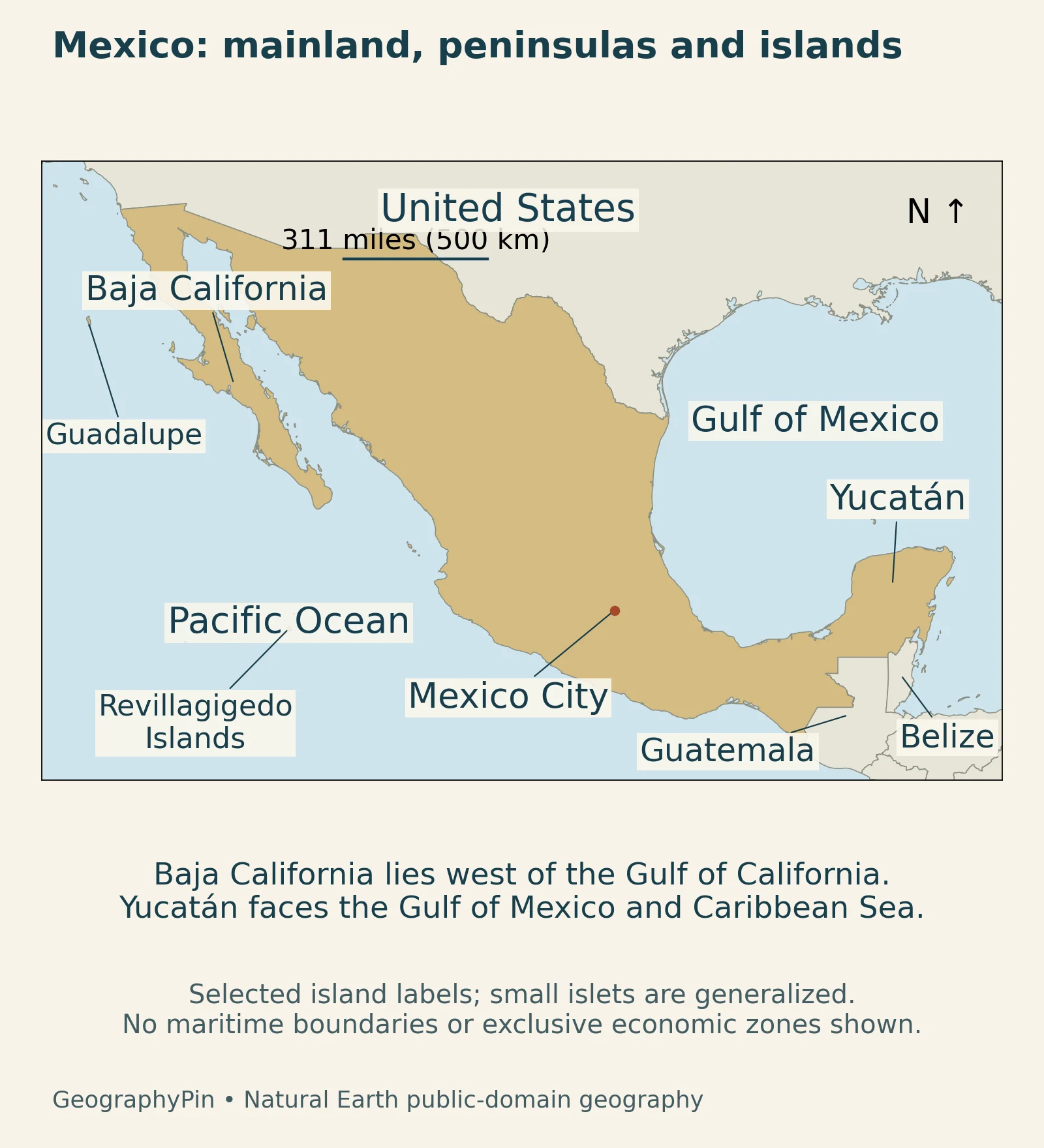
Mexico occupies the southern part of North America. The United States borders it to the north, while Guatemala and Belize meet its southeastern edge. The Pacific Ocean lies to the west and south; the Gulf of Mexico and Caribbean Sea lie along its eastern side. The Gulf and Caribbean coasts face the Atlantic basin; the western coast faces the Pacific.
Two peninsulas on opposite sides of the country
Baja California projects southward along the Pacific side, separated from the mainland by the Gulf of California. Yucatán projects into the waters between the Gulf of Mexico and Caribbean Sea. Their shapes are recognizable on a locator, but their geology, elevation and drainage differ sharply. The same word, peninsula, describes their coastal position rather than a shared type of landscape.
The Pacific islands also belong in the national picture. Guadalupe and the Revillagigedo Islands lie well away from the mainland coast, so a map cropped tightly around continental Mexico would leave out part of the country.
2. Country facts with dates and scope
| Topic | Fact | Scope |
|---|---|---|
| Capital | Mexico City | Distinct from the neighboring State of Mexico |
| Continental area | About 757,000 sq mi (1.96 million km²) | INEGI figure reproduced in the SICT 2024 yearbook; excludes islands |
| Population | 130,911,314 people | INEGI estimate for October 15, 2025 |
| Political system | Federal republic | States and Mexico City form the federation |
| Currency | Mexican peso | National monetary unit |
| Languages | Spanish and recognized Indigenous languages | National-language status under Article 4 of the linguistic-rights law |
INEGI’s 2025 Intercensal Survey estimates the total population at its October 15 reference date. That total is not identical to the survey’s private-household population: it also incorporates complementary estimates for people in collective accommodation and other groups outside that household count.
The SICT yearbook labels its 1,960,647 km² area figure as excluding islands; the table preserves that scope. Mexico’s Pacific and Caribbean islands still form part of its national territory. Article 40 of the Constitution establishes the federal republic, while Article 1 of the Monetary Law names the peso as the monetary unit.
3. Mountain rims, plateau and volcanic belt
Sierra Madre ranges frame an elevated interior
The Sierra Madre Occidental runs along the western side of the mainland, while the Sierra Madre Oriental lies farther east. Between them, the Mexican Plateau forms an extensive interior upland. “Plateau” does not mean a perfectly flat surface: basins, ridges and local mountains interrupt the higher country. The federal education ministry’s relief overview is useful for understanding this arrangement.
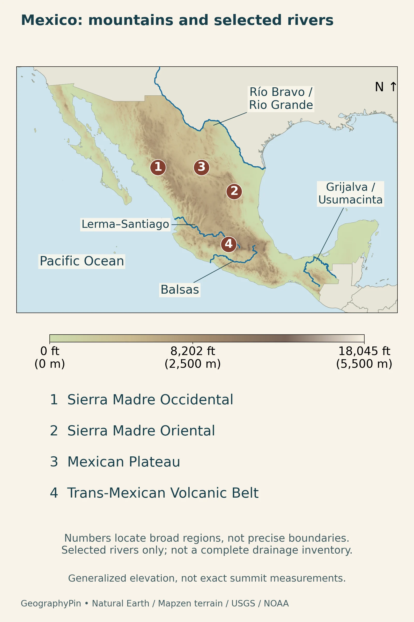
Read the map from west to east: first the Pacific-side uplands, then the interior plateau, then the eastern mountain rim and Gulf-facing lowlands. A short distance on a national map may cross several of these environments. That is why elevation and slope help explain Mexico more clearly than latitude alone.
The volcanic belt crosses the southern highlands
The Trans-Mexican Volcanic Belt, also called the Eje Neovolcánico, crosses central Mexico in a different direction from the long north–south mountain rims. The Mexican Geological Survey connects its volcanism with the subduction of the Cocos and Rivera plates beneath North America. It is not simply the southern continuation of one Sierra Madre range.
Popocatépetl and Iztaccíhuatl are familiar volcanic landmarks in this central highland setting. The December 2024 featured photograph looks across Puebla’s settled basin toward their volcanic skyline.
4. Baja California and Yucatán: contrasting peninsulas
Baja California is mountainous as well as dry
The Baja California Sur biodiversity study describes sierras, plateaus, plains and long coasts within the southern peninsula. Dry lowlands are prominent, but the higher Sierra La Laguna has cooler, more wooded environments. The peninsula therefore cannot be understood as one flat strip of desert. Its Pacific-facing and Gulf-facing sides also occupy different coastal settings.
This example is specifically from Baja California Sur, the southern state. The locator shows the coastal outline; the relief map explains why the interior is more varied than that outline suggests.
Yucatán’s limestone moves much of its water underground
In Yucatán, rock structure is central to understanding the landscape. UNAM’s aquifer research explains how slightly acidic rainwater dissolves carbonate rock over time. Fractures and caves provide pathways for groundwater, while cenotes expose parts of the system. Water can eventually discharge into coastal waters or beneath the sea.
Rainfall, fractures and underground passages vary across the peninsula, so its aquifer is not one uniform reservoir. Nor does underground drainage mean that the entire peninsula has no surface rivers. The useful contrast with Baja California is between a predominantly limestone groundwater landscape and a peninsula with conspicuous mountain ranges and dry lowlands, not between two identical coastal regions.
5. Climate and drainage across the relief
Elevation changes the meaning of “tropical”
Mexico spans dry northern and interior regions, warmer coastal lowlands and cooler highlands. The federal climate teaching resource explains the combined effects of latitude, elevation and mountain exposure. Air rising on Gulf-facing slopes of the Sierra Madre Oriental can bring rain, while sheltered inland slopes are drier. A coastal town and a highland city at a similar latitude can consequently have different climatic settings.
Season, slope direction and elevation matter within each region. Describing all of Mexico as either tropical or desert misses the contrast between its coasts, interior basins and higher mountain environments.
Some rivers reach an ocean; others end inland
CONABIO’s drainage overview distinguishes Pacific drainage, Atlantic drainage toward the Gulf of Mexico and Caribbean, and interior basins without an ocean outlet. The Grijalva and Usumacinta are important southeastern river systems. These southeastern river systems contrast with streams in closed interior basins, which have no outlet to the sea.
The map identifies selected courses, including the Río Bravo, called the Rio Grande in the United States, the Balsas, and the Lerma–Santiago system. The courses help connect the country’s physical regions, but do not show every tributary, reservoir or drainage divide.
6. People, cities and languages
Mexico City is not the State of Mexico
The name Mexico operates at several geographic scales. Mexico is the country; Mexico City is its capital and a federal entity; the State of Mexico is a separate neighboring entity. A population for one cannot be assigned to another. Metropolitan totals may cross administrative boundaries as well, making the definition especially important when comparing cities.
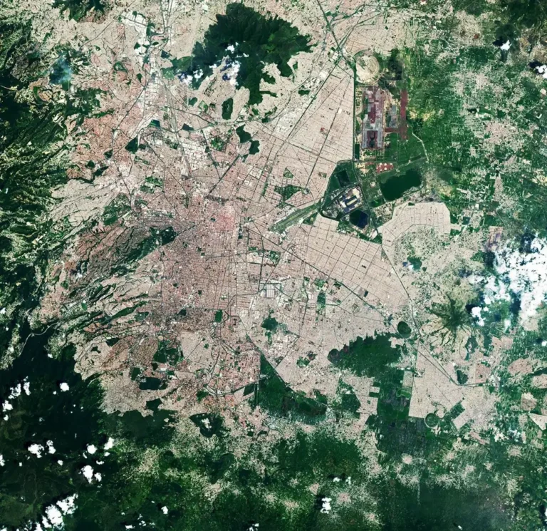
The capital’s high-basin setting also illustrates why a country profile needs more than a coast map. For the former lake landscape, elevation and water-management issues of the capital, see the separate Mexico City geography article. Here, the city is one part of a much wider national pattern of uplands, peninsulas, coasts and border regions.
Language categories describe different things
INALI’s classification identifies 11 Indigenous linguistic families, 68 linguistic groupings and 364 variants. These are different levels of classification, not three competing totals for the same category. The linguistic-rights law recognizes Spanish and the Indigenous languages covered by the law as national languages with equal validity. Calling Spanish the country’s only legally recognized language would erase that distinction.
7. Economy in its geographic setting
Manufacturing, urban hubs and coastal gateways
The OECD’s 2024 assessment describes how North American trade integration has supported export-oriented manufacturing, including vehicles and electronics. Northern and central regions have benefited more from these opportunities than southern regions. The pattern is broader than a narrow strip along the United States border: transport, water and reliable energy also shape where production can develop.
Mexico City is another important economic node. INEGI’s economic-census results place it prominently in the value added recorded by the census, while commerce and services account for substantial activity across the covered establishments.
Tourism creates a different set of connections. The federal tourism programme identifies Cancún, Mexico City, Los Cabos and Puerto Vallarta as major international air-arrival gateways in its 2024 evidence. They span a Caribbean coast, an inland capital, the Baja California peninsula and the Pacific mainland. Their geographic variety helps explain why a single beach image is an incomplete picture of Mexico’s visitor economy.
What Did We Learn Today?
Mexico’s physical regions are connected but not interchangeable. Mountain rims and an interior plateau differ from the volcanic belt, while Baja California and Yucatán illustrate contrasting geology and drainage. Elevation and exposure complicate simple climate labels. Country statistics and city comparisons become clearer when their reference dates, territorial coverage and administrative boundaries are kept distinct.
Sources & Data Notes
Population is INEGI’s total estimate for October 15, 2025, not just the private-household survey population. Continental area follows the INEGI figure reproduced in the SICT 2024 yearbook, whose footnote excludes islands; it is not a combined mainland-and-island total or a maritime jurisdiction figure. Historical physical-geography descriptions are used for landforms and drainage, not current rainfall, river discharge or volcanic activity.
- INEGI: 2025 Intercensal Survey, population and methodology
- SICT: Statistical Yearbook 2024, table 5.1.1 and area footnote
- UNAM Museum of Constitutions: Article 40
- Federal legal repository: Monetary Law, Article 1
- Mexican Geological Survey: mountain systems and volcanic belt
- Federal education ministry: Mexico’s relief
- CONABIO and Baja California Sur: physical environment
- UNAM Institute of Engineering: understanding the Yucatán aquifer
- Federal education ministry: climate and relief in Mexico
- CONABIO: rivers, lakes and drainage
- INALI: linguistic families, groupings and variants
- General Law of Linguistic Rights of Indigenous Peoples, Article 4
- OECD Economic Survey of Mexico 2024, chapter 3
- INEGI: 2024 Economic Census, final results released July 2025
- Federal Tourism Sector Programme 2025–2030, regional context
Original maps: GeographyPin, using Natural Earth public-domain geography and rivers. Terrain: Mapzen, with SRTM and GMTED2010 data courtesy of the U.S. Geological Survey and ETOPO1 data courtesy of NOAA. Elevation is generalized from actual terrain tiles; river lines are selected source geometry. Numbered markers identify broad regions, not exact boundaries. Islands are not shifted, and maritime claims are not mapped.
Featured photograph: Puebla with Popocatépetl and Iztaccíhuatl, December 25, 2024, Luisalvaz, CC0 1.0. Resized without cropping or added watermark.