Latvia’s rivers reveal more about the country than a simple description of flat Baltic terrain. The Daugava connects inland landscapes with Riga and the sea, while the Gauja cuts through a valley known for sandstone outcrops and wooded slopes. Between them lie lowlands, modest uplands, forests, cultivated fields and wetlands.
Latvia is a Northern European country between Estonia and Lithuania, with Riga as its capital. It borders the Baltic Sea and Gulf of Riga and combines extensive lowlands with hilly uplands and river valleys. The Daugava, Gauja, Lielupe and Venta connect different parts of the country with the Baltic basin.
How to use this article: Compare Latvia’s Baltic position, explore the physical landscapes, or distinguish historical regions from local government.
1. Locate Latvia and distinguish the Baltic states
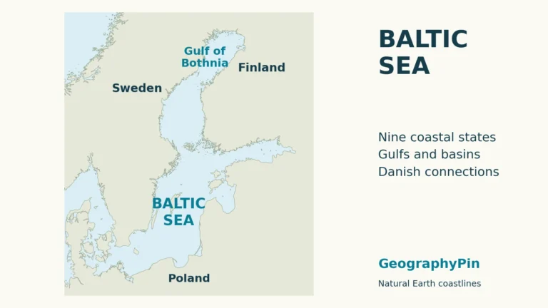
Latvia borders Estonia to the north, Lithuania to the south, Russia to the east and Belarus to the southeast. Its western coast faces the Baltic Sea, while the Gulf of Riga forms a broad indentation along the northern maritime side. The gulf is part of the Baltic Sea, not an isolated inland lake.
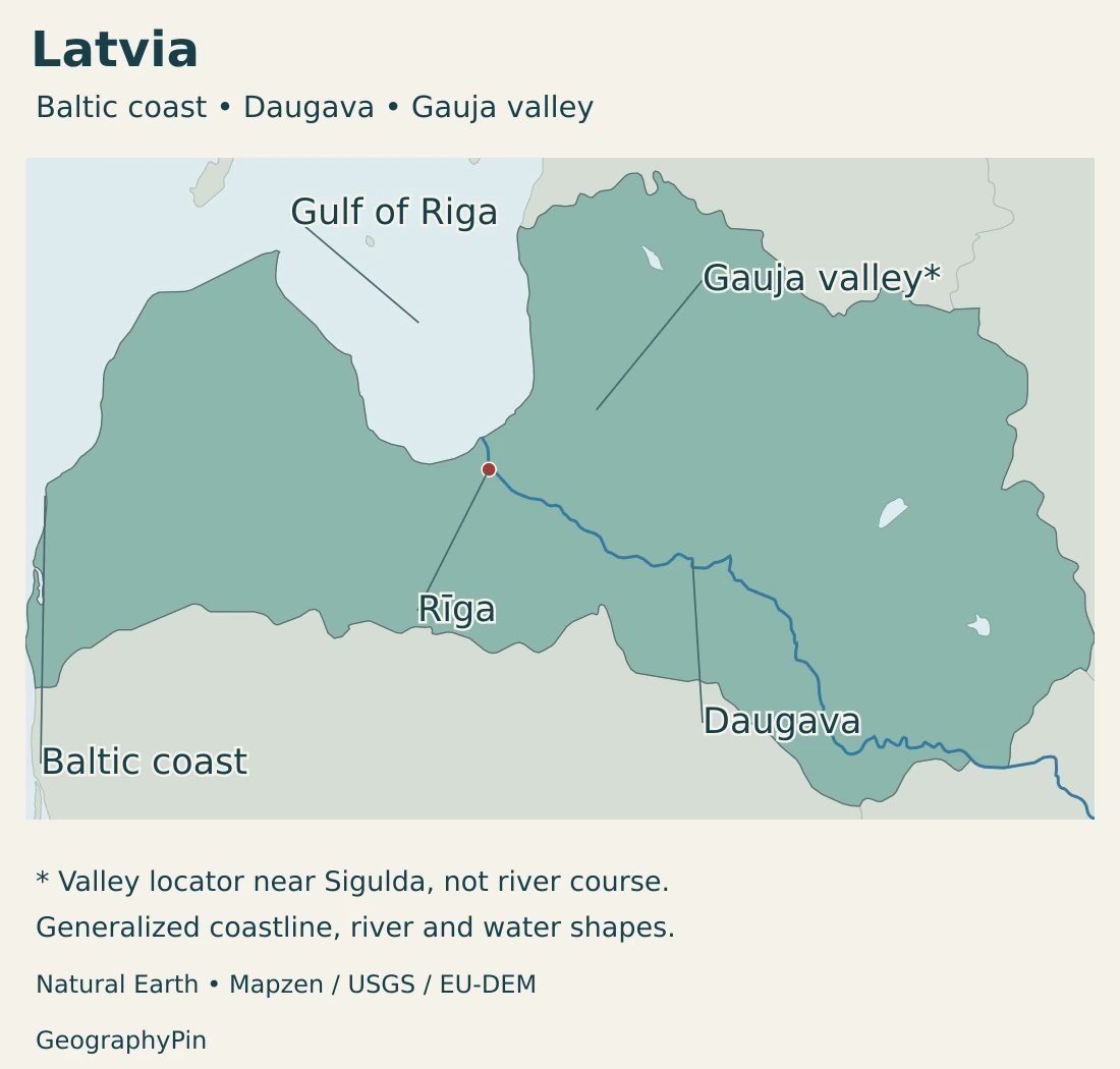
Riga lies near the lower Daugava and the Gulf of Riga. This position joins an inland river corridor with maritime routes. The capital’s location is different from an exposed open-sea port on the western coast, even though both belong to the same wider Baltic setting.
Latvia occupies the middle position, not a separate landscape world
Latvia is the middle of the three Baltic states when moving north to south: Estonia, Latvia and Lithuania. They share a Baltic maritime setting, but they are separate countries with distinct capitals and different combinations of coast, rivers, uplands and settlement.
Latvia’s particular geographic signature is the relationship between the Gulf of Riga, its lowlands and the Daugava and Gauja landscapes. Estonia’s large western islands are a different coastal pattern. The comparison is useful without suggesting that forests, lakes or lowlands belong exclusively to any one Baltic country.
See our Baltic countries map for the regional comparison and our Baltic Sea guide for the shared marine setting.
2. Country facts and dated statistics
| Item | Fact | Date or scope |
|---|---|---|
| Capital | Riga | Capital near the lower Daugava and Gulf of Riga |
| Population | 1,845,096 | Usual-resident population at the beginning of 2026 |
| Area | About 24,940 sq mi (64,594 km²) | Geographical size in the EU country profile, attributed to Eurostat 2026 |
| Official language | Latvian | Constitutional status, with separate cultural and minority-language protections |
| Currency | Euro (EUR) | Euro-area member since January 1, 2014 |
| Government | Parliamentary republic | Prime minister leads the government; president is head of state |
| Local government | 42 local governments | 35 municipality governments and seven state-city governments after the 2025 local elections |
A usual-resident population is not a citizenship count
The beginning-of-2026 figure describes usual residents, not all Latvian citizens wherever they live. Since 2025, the Central Statistical Bureau has used a method that evaluates activity in administrative registers to estimate whether a person usually lives in the country. The annual figure is therefore a statistical population estimate, not a new nationwide door-to-door census.
The national population, the population within Riga’s administrative boundary and the number living in its wider commuting area describe different geographic units. A figure for one should not be used as a substitute for another simply because all are associated with the capital.
Area measurements likewise need a source and definition. The country figure in the table is not a coastline length or a measure of the sea reached by Latvia’s ports. It should not be combined with an unrelated land-only figure to create an apparently precise comparison.
3. Lowlands, uplands and river valleys
Compare the main landscape settings
| Landscape | Setting | Geographic character |
|---|---|---|
| Coastal lowlands | Baltic coast and Gulf of Riga margins | Low terrain, coastal habitats and settlements linked to the sea |
| Zemgale plains | Southern and central-southern Latvia | Broad, comparatively flat agricultural landscapes with fertile fields |
| Gauja valley and adjoining uplands | Northern and northeastern interior | Wooded slopes, tributary valleys and prominent sandstone exposures |
| Eastern lake and hill landscapes | Latgale and adjoining inland areas | Lakes, rolling terrain and river landscapes away from the main maritime frontage |

The country is predominantly low-lying, but local slopes and valleys can be quite distinct. An upland is elevated relative to its surroundings; it need not be a high mountain range. Conversely, a lowland is not necessarily level at every point or free of wetlands and river channels.
Sandstone gives the Gauja valley its own character
Gauja National Park protects an ancient river valley and its surrounding landscapes. Devonian sandstone outcrops appear along the Gauja and its tributaries, creating cliffs and exposed rock faces that contrast with the wooded slopes.
The valley is both a physical landform and a cultural landscape, with historic sites and established recreation areas. These uses do not make the whole park uniformly accessible or equally developed. The protected area includes places with different conservation functions, rather than a single continuous visitor zone.
Fields in Zemgale and lakes in Latgale
Zemgale’s relatively flat, fertile fields help explain its agricultural identity. This open cultivated setting differs from the steeper valley scenery around the Gauja. Terrain, soils and water movement influence how land is used, even within a country without major mountain barriers.
Latgale provides another contrast through its numerous lakes and hilly landscapes. The Daugava’s bends between Krāslava and Daugavpils add a river corridor to that eastern setting. A region associated with lakes can therefore also contain important towns, farms and river valleys.
4. Daugava, Gauja and the changing water landscape
The Daugava is not the only route to the sea
The Daugava is a major river and basin associated with Riga, but Latvia contains several distinct drainage systems. The Gauja reaches the Gulf of Riga, the Venta drains much of the west toward the Baltic Sea, and the Lielupe drains central Latvia.
A basin includes tributaries and the land supplying their runoff, not just the channel marked on a map. A river valley, a drainage basin and a local-government boundary consequently describe different spaces. Water conditions downstream can be influenced by activities far from the main riverbank.
Hydropower changes the Daugava landscape
The Pļaviņas, Ķegums and Riga hydropower plants form a cascade on the Daugava. Their reservoirs and operating infrastructure mean that parts of the river are managed landscapes, not an uninterrupted natural channel.
Hydropower output depends on water inflow. The operator describes strong seasonal differences, with spring high-water periods contrasting with lower-water conditions. Installed generating capacity is therefore not the same thing as electricity produced continuously throughout the year.
Wetlands connect habitat and water management
The Great Ķemeri Bog illustrates a different water landscape: peatland with pools and specialized habitats rather than a major flowing river. In the nearby Dunduri Meadows, a formerly straightened section of the Slampe River was restored to a meandering course as part of wetland restoration.
Such work shows why conservation is not limited to protecting scenery. The shape of a channel and the way water spreads through adjoining land influence habitats. Wetland restoration and the management of grazing can both contribute to maintaining a varied landscape.
Sea influence does not eliminate seasonal contrasts
Latvia has a temperate climate with four recognizable seasons. Its relatively low relief, proximity to the Baltic Sea and air masses arriving from the Atlantic all influence conditions. The country’s climate is therefore more than a latitude or a single national average.
Weather can change rapidly, and a wet year can still include a dry spell. Long-term climate patterns help explain environmental conditions, but they do not specify the river flow, storm exposure or soil moisture on a particular day.
5. Riga, regional identities and languages
Riga connects national institutions with a river mouth
Riga is both the capital and a major maritime gateway. Its port extends along the lower Daugava toward the gulf, illustrating how an urban economy can occupy a river corridor rather than a single point beside the sea.
Eastern Latvia has a different setting. Daugavpils belongs to the Latgale landscape and the Daugava corridor, far from the gulf-facing capital. The contrast between these locations is useful for understanding how one river links very different parts of the country.
Historical regions are not the current local-authority map
Latvia’s historical regions are Vidzeme, Latgale, Kurzeme, Zemgale and Sēlija. The law recognizes their cultural and historical identities and the belonging of towns and rural territories to them. Riga has a distinctive metropolitan identity while forming a historical part of Vidzeme under that law.
These regions should not be confused with physical landforms or the units responsible for local government. Zemgale’s agricultural plains are a geographic association; a historical-region boundary is a cultural and legal classification. Neither automatically describes a drainage divide.
Official language and cultural protection are different roles
Latvian is the official language. The language law also protects Latgalian written language as a historical variant of Latvian and Livonian as an indigenous language. Those protections do not make each language a separate nationwide co-official language.
The Constitution protects the rights of people belonging to ethnic minorities to preserve and develop their language and cultural identity. The official-language law does not regulate private informal communication in the same way as official functions.
A person’s citizenship, usual residence and language use answer different questions. The official-language framework does not mean that everyone living in Latvia has the same mother tongue, and the national population statistic is not a language census.
6. Government, energy and maritime connections
Latvia is a parliamentary republic. Its parliament, the Saeima, has 100 members. The Cabinet is led by the prime minister and depends on parliamentary confidence; the president serves as head of state.
Current local government comprises 42 authorities: 35 municipality governments and seven state-city governments. This is a different classification from the five historical regions. The reduction from 43 followed the incorporation of Varakļāni’s local government into Madona after the 2025 local elections.
A port depends on the connections behind it
The Freeport of Riga lies at the Daugava’s mouth in the Gulf of Riga. Port activity connects maritime transport with the city and inland routes. Its geographic role comes from the combination of river, sea access and facilities, not simply from being a coastal location.
Ports, hydropower plants and agricultural areas also depend on different kinds of infrastructure. A functioning transport link matters to cargo movement, while river inflow matters directly to hydropower generation. These activities share a national economy without responding to exactly the same environmental conditions.
Physical geography creates opportunities, not guarantees
Fertile plains support agriculture; river valleys and protected landscapes support recreation; the Daugava provides a setting for energy infrastructure and urban connections. None of these relationships means that land use is determined by nature alone. Planning, investment and environmental protection shape how the opportunities are used.
Latvia’s country profile is therefore a combination of enduring landscapes and changing human decisions. Its lowlands and river corridors provide the framework, while towns, local authorities and transport systems organize everyday life within it. For the wider political map, see our European countries and capitals guide.
Frequently Asked Questions
Is the Gulf of Riga separate from the Baltic Sea?
It is a gulf within the Baltic Sea, not a separate inland lake. Riga lies near the lower Daugava where the river reaches the gulf.
Are the Daugava and Gauja the same river?
No. They are separate rivers and drainage systems. Both are important to Latvia, but the Daugava’s hydropower cascade and Riga connection differ from the Gauja valley’s sandstone landscapes.
Is Latvia completely flat?
No. Extensive lowlands coexist with modest uplands, hills and incised valleys. The contrast between Zemgale’s plains and the Gauja valley is a useful example.
What Did We Learn Today?
Latvia occupies the middle position among the Baltic states, with Riga linking the lower Daugava to the Gulf of Riga. Lowlands, agricultural plains, wooded valleys, lakes and wetlands create important contrasts within a relatively low-relief country. Distinguishing river basins, historical regions and current local authorities makes both the physical and human geography clearer.
Sources & Data Notes
Population and administrative figures retain their stated dates. Historical regions, physical landscapes, river basins and local-government units are separate classifications.
- Central Statistical Bureau: population at the beginning of 2026: June 2, 2026 release and usual-residence signs-of-life methodology; the EU profile provides the matching unrounded annual total.
- European Union: Latvia country profile: 2026-attributed population and geographical size, capital, currency and parliamentary system. Area is retained as a published geographic measure without an inferred land–water split.
- Regional-development ministry: local governments: Updated September 3, 2026: 42 authorities after the 2025 elections, replacing the earlier 43.
- Constitution of Latvia: Official language, Saeima, Cabinet and minority cultural rights. English translation provided for information.
- Official Language Law: Latvian, Latgalian written language, Livonian and the distinction between official functions and private communication.
- Law on Historical Regions of Latvia: Five historical regions and Riga’s historical relationship to Vidzeme, distinct from current local-government units.
- European Commission: Latvia river-basin assessment: February 2025 report, general characterization: lowlands and hills, Gauja, Daugava, Venta and Lielupe drainage. Older demographic figures are outside this profile’s statistical table.
- Nature Conservation Agency: Gauja National Park: Ancient valley, Devonian sandstone outcrops and protected landscape functions.
- Latvian tourism agency: Zemgale: Southern plains and fertile agricultural landscapes.
- Latvian tourism agency: Latgale: Lakes, hilly terrain and the Daugava landscape near Daugavpils and Krāslava.
- Latvia: First Biennial Transparency Report: December 2024 national submission, section 3.1: temperate climate, Atlantic air masses and low relief. Individual historical weather observations are not current conditions.
- LatViaNature: habitat restoration: June 2026 primary account of Ķemeri bog, Dunduri Meadows and re-meandering of the Slampe.
- Elektrum Group: electricity generation: Three Daugava hydropower plants and the relationship between inflow and electricity generation; no fixed generation share is assumed.
- Freeport of Riga Authority: port location: Lower Daugava, Gulf of Riga and port–city connections.
Map sources and scope: Original GeographyPin maps use Natural Earth country, river, lake and populated-place data. Natural Earth data are public domain. Boundaries and coastline are generalized modern source geometry, not an official boundary survey. No internal administrative boundaries are invented. Names and geographic context also use the PCGN Latvia factfile.
Rīga uses Natural Earth city-coordinate attributes. The Daugava follows actual source river linework. The selected river dataset does not contain the Gauja, so its label is an explicit valley locator near Gūtmanis Cave, not an invented river course. The landmark position comes from the official Latvia Travel Vidzeme map brochure, with context from the official cave description. Coastal and valley labels are broad locators rather than measured physical-region boundaries. Water shapes are not current water-level or navigation data.
Hillshade is calculated from genuine elevations accessed through Mapzen Terrain Tiles, without vertical exaggeration. Global elevation data courtesy of the U.S. Geological Survey. Produced using Copernicus data and information funded by the European Union – EU-DEM layers. Elevation-source attribution and terms apply. Historical elevation is not a current surface survey, and relief shading is not bathymetry or numerical elevation bands.
The cover uses Latvia flag artwork from Commons. The intact 2:1 flag with 2:1:2 stripe proportions appears separately from the decorative outline motif.