Mountain names around Misurina often appear together in photographs and travel plans, but they do not identify the same place. Separating the lakeshore from nearby lakes, mountain refuges and the Tre Cime peaks makes the Dolomite landscape much easier to read.
Lake Misurina is a small natural lake in Auronzo di Cadore, Veneto, in Italy’s Dolomites. Geological mapping identifies a moraine barrier behind its formation. Cristallo, Sorapiss and the Cadini frame its setting, while nearby Lake Antorno, Rifugio Auronzo and the Tre Cime peaks are separate destinations rather than parts of the lakeshore.
How to use this article: Orient yourself among the surrounding mountains, examine the lake’s glacial deposits, or separate Misurina from Tre Cime destinations.
1. Where Is Lake Misurina?
Lake Misurina, or Lago di Misurina, lies in the municipality of Auronzo di Cadore, in Belluno province, Veneto, northern Italy. Misurina is also the name of the lakeside locality. It is not the town center of Auronzo, and a reference to nearby Cortina d’Ampezzo does not move the lake into Cortina’s municipality.
Orient the lake before naming the skyline
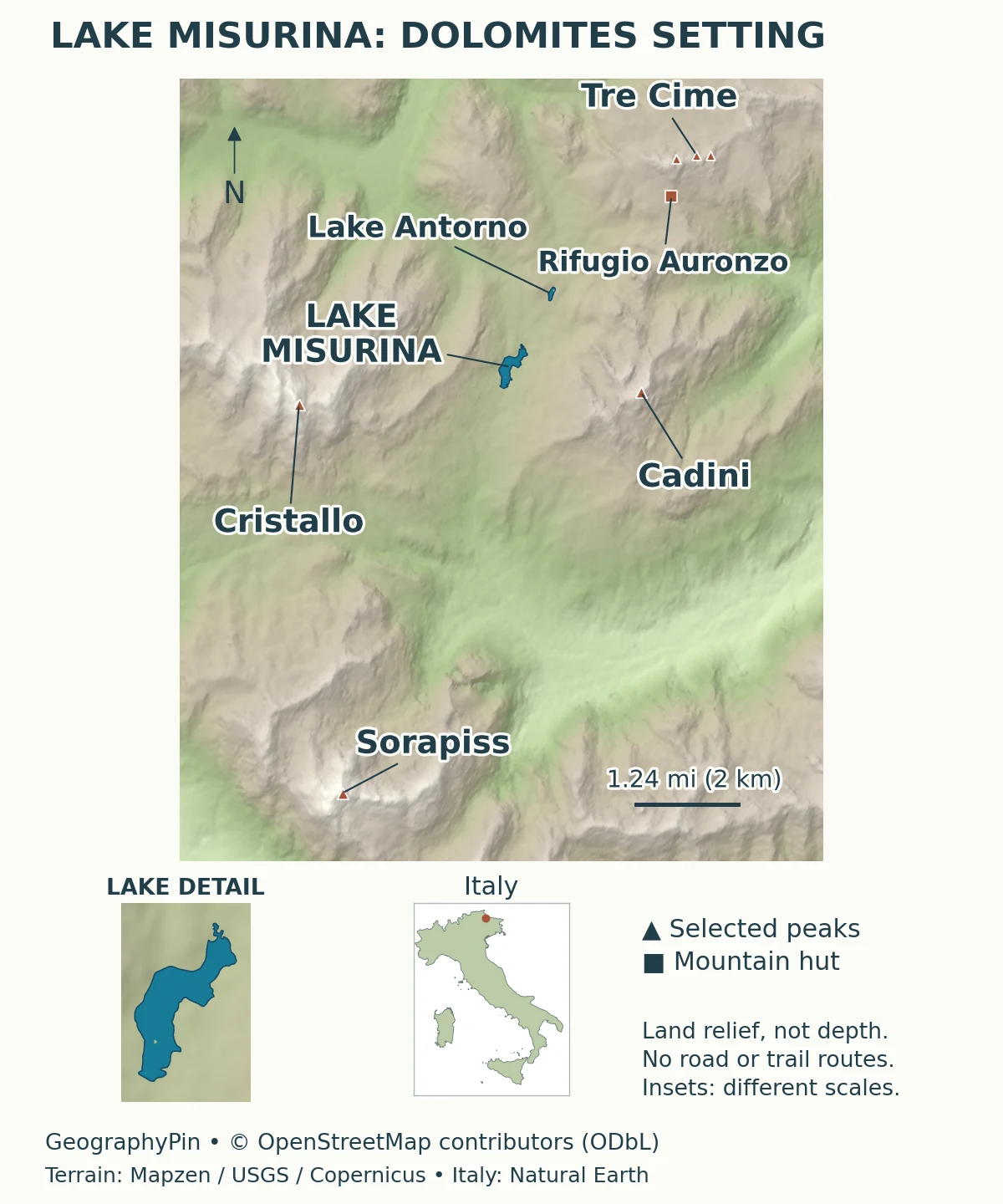
Cristallo lies to the west, the Sorapiss group to the south, and the Cadini di Misurina to the east. The Tre Cime di Lavaredo rise farther to the northeast. These names refer to different parts of the surrounding relief; “the Dolomites” is the broader mountain setting, not the name of a single wall of peaks behind the lake.
The original locator uses individual summit positions to anchor the mountain names. Those points help establish direction, but they are not boundaries around whole mountain groups. The enlarged lake outline serves a different purpose: it makes the small water body legible within a much larger landscape.
2. Lake Facts and Measurement Sources
Misurina is a small, shallow natural lake rather than a deep Alpine basin. The table keeps each value tied to its source. Elevation describes height above sea level; depth describes water below the surface. The two are not interchangeable, even when both are expressed in feet or meters.
| Fact | Reference | What it describes |
|---|---|---|
| Location | Auronzo di Cadore, Belluno, Veneto | Municipality and province, not a distance from a resort |
| Lake elevation | About 5,760 feet (1,756 meters) | Local tourism consortium reference |
| Surface area | About 0.04 square miles (0.1 square kilometers) | Rounded ARPAV public-summary value |
| Maximum depth | About 15 feet (4.5 meters) | ARPAV public-summary reference, not a current sounding |
Do not combine different tables into a false precision
ARPAV’s general lake page, updated in 2022, gives the rounded area and maximum depth above. An older Belluno report published in 2009 instead lists about 0.066 square miles (0.172 square kilometers) and about 16 feet (4.8 meters). The cited sources do not explain a common measurement method that would let us reconcile those differences confidently.
The difference should not be presented as proof that Misurina has recently shrunk or become shallower. These are published reference figures, not a time series of comparable surveys. The geographic map also uses an illustrative shoreline from a different dataset; it is not a new bathymetric or water-level survey.
3. A Moraine-Dammed Basin in the Dolomites
Glacial deposits can act as a natural barrier
The geological notes for Italy’s official Cortina d’Ampezzo map sheet identify a frontal moraine as the barrier responsible for Lake Misurina. A moraine is accumulated sediment left by a glacier. In this case, the mapped deposits blocked the upper Ansiei drainage and helped water collect behind the barrier.
The same specialist account places the barrier’s formation in the early Late Glacial, without providing a simple calendar year for the lake’s birth. That is more useful than assigning an unsupported exact age. It also explains why calling the lake “glacial” need not mean that its entire basin was excavated as a deep rock bowl.
Glacial erosion and glacial deposition are different processes. A glacier can scour a valley, but the sediment it leaves behind can also obstruct drainage after the ice retreats. Our guide to glacial erosion landforms covers the erosional side; Misurina illustrates why a lake’s explanation may also require the deposits around it.
The landscape contains other kinds of landforms too, but the presence of steep cliffs or loose rock does not by itself prove a landslide origin for this lake. The moraine-dammed interpretation here follows the geological mapping rather than inferring a cause from a photograph.
4. Drainage: From Misurina Toward the Ansiei
A shallow lake connects to a wider drainage network
ARPAV’s Belluno report identifies the Ansiei as Misurina’s outlet and describes local aquifers associated with the surrounding morainic deposits as sources of lake water. This connects the visible lake with the less visible water stored and moving through nearby sediments.
Farther downstream, the Ansiei passes through the Auronzo area and joins the Piave. Lake Santa Caterina, also associated with Auronzo, is a different water body: ARPAV identifies it as an artificial basin on the Ansiei. It should not be substituted for natural Lake Misurina in a photograph, map or lake-facts table.
This drainage description is not a real-time water balance. It does not supply today’s inflow, discharge or water level, and the map does not invent groundwater pathways through the moraine. A naturally formed lake can also have later management works; origin and present-day operation answer different questions.
Water appearance alone is not an environmental assessment. A clear-looking reflection, an old monitoring classification or the lack of visible surface inflow cannot establish current bathing conditions. This profile explains the basin and its drainage rather than making a swimming or ice-safety recommendation.
5. Misurina, Antorno and Tre Cime Are Different Destinations
The lake is not the famous north-face viewpoint
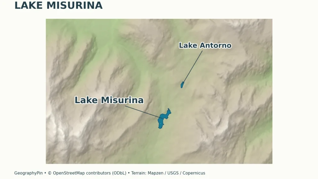
Lake Antorno lies north of Misurina and is a separate small lake. Rifugio Auronzo is a mountain hut near the Tre Cime, not a building on Misurina’s shore. The three Tre Cime peaks are the mountain destination itself. Distinguishing these places is essential when reading a route description that begins with “from Misurina.”
The local tourism consortium describes the Tre Cime view from Misurina as a southwest-side view. The famous northern walls are seen from a different side of the mountains. A lakeside photograph and a photograph of the north faces can therefore show the same mountain group without representing the same viewpoint.
The consortium also describes the access road from near Antorno toward Rifugio Auronzo, which stands at about 7,654 feet (2,333 meters). That is substantially higher than the lake. The road’s existence does not imply year-round access, an unrestricted parking place or a fixed travel time. For current arrangements, use the official Tre Cime visitor information.
The locator marks destinations but deliberately omits a route line. A straight connection between a lake and a hut would not represent the winding road, and a label beside a summit would not represent a hiking trail. Navigation requires a suitable route map and current local information.
6. How to Read the Setting Before Visiting
Choose the scale of the outing first. A walk beside the water, a visit to Antorno and a mountain excursion around Tre Cime are distinct plans. Similar names and close spacing on a small locator do not mean similar terrain or effort.
Around Misurina, the foreground is a modest lake and settlement, while the skyline belongs to much larger mountain groups. That contrast explains the scene better than treating the lake as a vast wilderness basin. It also explains why different shore positions change which peaks dominate a photograph.
For arrangements on the ground, consult the local Misurina tourism information and the current notices for the specific road, lift or trail you intend to use. Seasonal descriptions are not an assurance that a service operates today.
The central geographic idea is straightforward: a moraine-dammed lake sits within a complex Dolomite landscape, connects to the Ansiei drainage and provides an approach to several separate destinations. Keeping those layers distinct makes the map more useful and prevents a familiar scenic image from becoming a misleading travel plan.
What Did We Learn Today?
Misurina is a small, shallow natural lake whose moraine-dammed origin and Ansiei outlet help explain its basin. Its surrounding mountain groups are distinct, as are the lake, Antorno and the Tre Cime access destinations. Source-specific measurements and a properly scaled map give a clearer picture than combining every nearby name into one attraction.
Sources & Data Notes
US customary equivalents are rounded. Published dimensions have different reference sources and should not be interpreted as a comparable record of lake change. Geological origin, local drainage and current access conditions are separate questions. Use current local information for access and conditions.
- Comune di Auronzo di Cadore: Misurina. Municipality and locality context.
- ARPAV: Veneto lakes overview. Rounded dimensions, natural-lake classification and distinction from Santa Caterina.
- ARPAV Belluno: water-monitoring report, March 2009. Pages 43 and 79: Ansiei drainage and local aquifers. Historical dimensions are kept separate from the later summary; old quality results are not presented as current.
- Geological Survey of Italy: Cortina d’Ampezzo sheet 029, explanatory notes. Pages 110 and 128–129: morainic barrier and lake formation. No exact calendar age is inferred.
- Consorzio Turistico Tre Cime Dolomiti: Misurina. Lake elevation and surrounding mountain context.
- Consorzio Turistico Tre Cime Dolomiti: Tre Cime di Lavaredo. Southwest-side views, separate north-face viewpoints and the Rifugio Auronzo access destination.
Map sources and method: Original GeographyPin cartography uses the complete OpenStreetMap lake outlines for Misurina and Antorno, actual summit positions and the Rifugio Auronzo building footprint. The selected summits orient mountain groups; they are not mapped massif boundaries. Lake shapes and positions: © OpenStreetMap contributors, ODbL. Historical Mapzen elevation tiles provide surrounding land relief, not lake depth or a route assessment. Global terrain data courtesy of the U.S. Geological Survey; European terrain produced using Copernicus data and information funded by the European Union – EU-DEM layers. Exact per-tile source composition was not independently resolved; see Mapzen source attribution. The Italy locator uses Natural Earth public-domain data. The main map uses a latitude-adjusted geographic aspect and an approximate scale bar; the two insets have separate scales.