
A map of Saipan alone cannot explain the Northern Mariana Islands. The commonwealth stretches along an island arc with very different landforms and a highly uneven settlement pattern. Guam continues the same geographic chain to the south, but it belongs to a separate jurisdiction.
The Northern Mariana Islands are a self-governing U.S. commonwealth in the western Pacific, separate from Guam. Their southern islands include Saipan, Tinian and Rota, with extensive limestone over older volcanic foundations. Farther north, islands such as Pagan and Anatahan display volcanic cones and calderas. The CNMI is not an independent country.
How to use this article: Separate the CNMI from Guam, compare limestone and volcanic landforms, or read the census pattern.
1. Locate the CNMI Without Adding Guam
One island chain, separate jurisdictions
CNMI abbreviates the Commonwealth of the Northern Mariana Islands. The geographic Mariana archipelago includes both the CNMI and Guam. Calling a place “Mariana” therefore does not identify which territorial government administers it.
Read the map from south to north: Rota lies north of Guam; Tinian and Saipan are farther along the arc. Beyond the southern group, the chain continues through islands including Anatahan, Pagan, Agrigan and Farallon de Pajaros. “Northern Mariana Islands” is the name of the whole commonwealth, not just its sparsely populated northernmost islands.
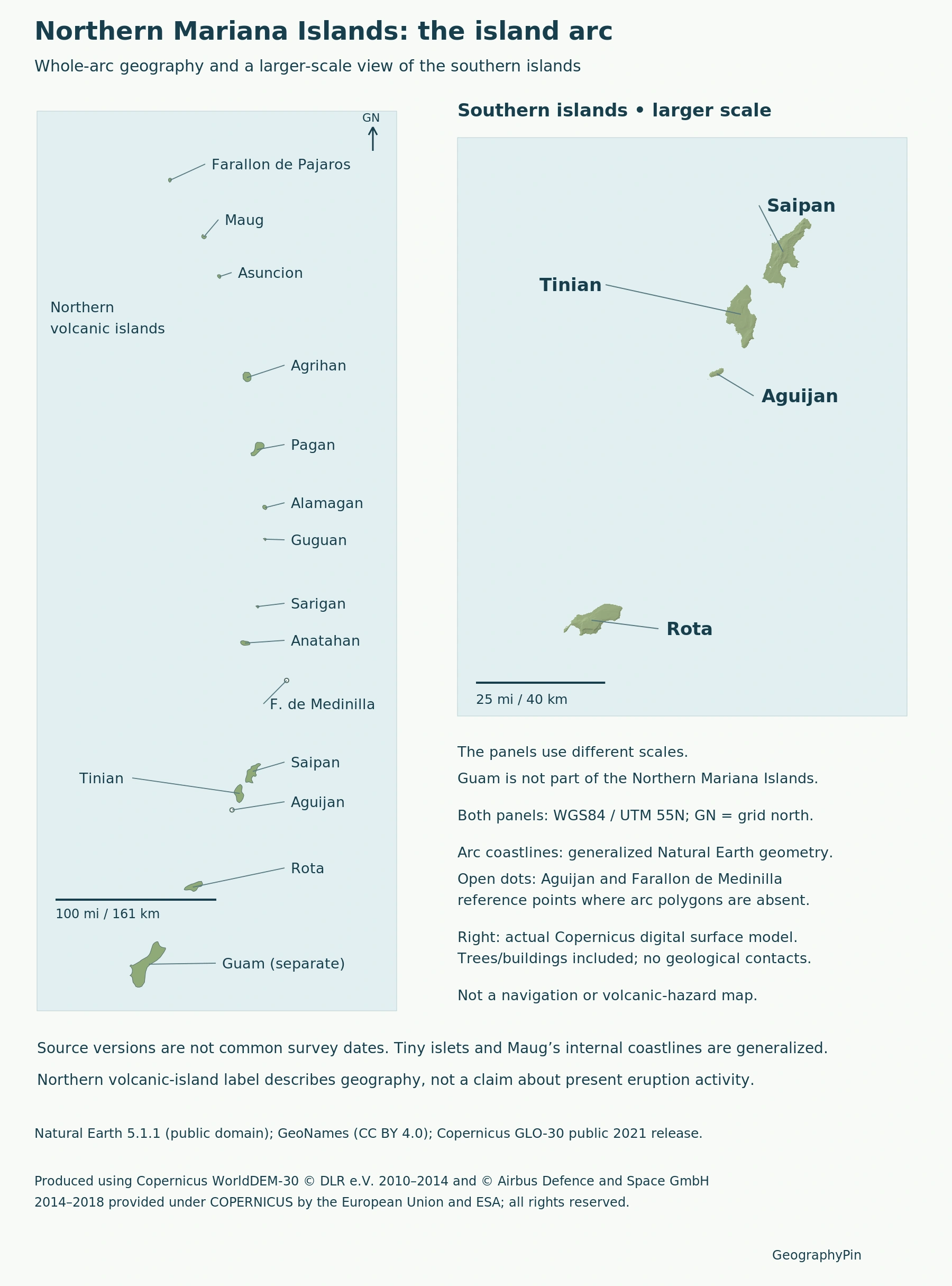
The two panels have different scales. The whole-arc view explains the chain’s extent; the southern enlargement makes Saipan, Tinian and Rota easier to compare. Open reference dots locate tiny islands omitted by the generalized arc polygons, rather than inventing enlarged island outlines.
2. Limestone-Covered Islands and the Mariana Arc
Older foundations beneath younger limestone
The older southern islands have volcanic origins but extensive coral-derived limestone raised above sea level. Saipan contains a volcanic core surrounded by younger limestone formations. “Limestone island” and “volcanic origin” are therefore compatible descriptions of different parts of its geological history.
Tinian lies across the Saipan Channel from Saipan, while Rota lies farther south toward Guam. Along Saipan’s western side, fringing and barrier reefs form part of the coastal setting. The 2005 CNMI reef assessment documents these physical relationships; its ecological observations should not be read as present-day reef conditions.
At the larger tectonic scale, the USGS describes the Pacific plate descending beneath the Philippine Sea plate at the Mariana Trench. This process, called subduction, links the deep-ocean trench with the volcanic arc. The trench is not the island chain itself, and neither feature is a political border.
A relief map shows the shape of the land, not its complete rock history. Hills and cliffs alone cannot tell the reader where limestone ends or volcanic rock reaches the surface; that requires geological mapping rather than a color change inferred from shaded terrain.
3. Pagan and Anatahan Show Different Volcanic Forms
Pagan is not a single symmetrical cone. The USGS describes two stratovolcanoes joined by a narrow isthmus, a strip of land linking the northern and southern parts of the island. Both volcanic centers developed within calderas, broad depressions associated with collapse of a volcanic system.
Pagan’s major 1981 eruption prompted evacuation. That historical event explains an important disruption to settlement, but it does not establish that the island or every northern island is permanently empty today. A volcanic history and a population census answer different questions.
Anatahan has an elongated shape and a compound summit caldera with eastern and western parts. Its first historically documented eruption occurred in 2003. “First documented” does not mean the island or its volcano first formed that year: the landform already recorded a much longer volcanic history.
These examples show why the northern arc should not be reduced to identical mountain symbols. An island may contain several volcanic centers, nested depressions or a narrow connection between larger masses. The map labels geographic islands; it does not assign current eruption levels or show access permissions.
4. Settlement Is Concentrated in the Southern Municipalities
The 2020 census pattern
The 2020 Census tables counted 47,329 people across the commonwealth. The four municipality totals reveal how strongly settlement was concentrated in the south.
| Municipality | Population |
|---|---|
| Saipan | 43,385 |
| Tinian | 2,044 |
| Rota | 1,893 |
| Northern Islands | 7 |
Saipan municipality accounted for about 91.7% of the total, calculated from 43,385 divided by 47,329. These are municipal units, not a new count of separate sovereign islands. The Northern Islands municipality’s seven residents also make “the entire north is uninhabited” an inaccurate description of this census.
The figures refer to 2020, not a 2026 population estimate. The large difference between Saipan and the other municipalities is more informative than placing the commonwealth’s total beside a map that shows only its largest settlement concentration.
5. What Commonwealth Status Means
The Covenant defines the CNMI as a self-governing commonwealth in political union with, and under the sovereignty of, the United States. It provides for internal self-government under a local constitution, while the United States has responsibility for foreign affairs and defense.
The framework includes an elected governor and legislature. “Commonwealth” does not mean an independent country or a U.S. state, and it does not make the CNMI part of Guam. Its constitutional relationship is distinct from merely sharing an island arc.
The agreement was signed in 1975, but U.S. approval became law on March 24, 1976. Provisions took effect in stages in 1976, 1978 and 1986. Treating all of those steps as one event in 1975 obscures the difference between signature, approval and implementation.
On a world map with countries, a separate Northern Mariana Islands label identifies the territory without making it an additional sovereign state.
What Did We Learn Today?
The CNMI is one jurisdiction within the wider Mariana chain, with Guam separate to the south. Limestone-covered southern islands contrast with the varied volcanic forms of Pagan and Anatahan, while the 2020 municipal counts show settlement concentrated on Saipan. Physical geography, census units and commonwealth status describe different aspects of the same arc.
Sources & Data Notes
Sources, dates and map conventions
Municipal populations are from the 2020 Census; Saipan’s share is calculated from the published counts. The 2005 reef chapter supports stable physical geography only, not current reef health. Volcano profiles supply landforms and explicitly dated historical examples, not live alerts. Map panels use different scales.
- CNMI Law Revision Commission: Covenant and implementation chronology
- U.S. Census Bureau: 2020 CNMI tables, municipality population counts
- U.S. Census Bureau: 2020 demographic profile release
- CNMI/NOAA reef assessment, 2005: physical setting, pages 399–403
- USGS: Philippine Sea plate and vicinity, regional tectonic setting
- USGS: Pagan landforms and historical eruption
- USGS: Anatahan landforms and historical eruption
Featured photograph: Northern Saipan, photographed May 28, 2011, by Abasaa (あばさー), via Wikimedia Commons; released into the public domain by the photographer. Resized and converted to WebP.

Original GeographyPin map: Natural Earth 5.1.1 public-domain arc coastlines, GeoNames points under CC BY 4.0, and Copernicus GLO-30 public 2021 southern terrain. Both panels use UTM 55N at different scales. Open dots mark missing tiny-island polygons; Maug’s internal coastlines are generalized. Terrain includes trees and buildings, not mapped geological contacts or current hazard zones.
Produced using Copernicus WorldDEM-30 © DLR e.V. 2010-2014 and © Airbus Defence and Space GmbH 2014-2018 provided under COPERNICUS by the European Union and ESA; all rights reserved.
The organisations in charge of the Copernicus programme by law or by delegation do not incur any liability for any use of the Copernicus WorldDEM-30. Copernicus DEM license.