Gori sits in the middle of Georgian history in a way few cities do. It is a fortress town, a transport hinge, a place shaped by invasion and rebuilding, and the city most closely tied to Stalin’s early life. That layered identity is what makes it more interesting than its reputation suggests.
Gori, Georgia, is best known as Stalin’s birthplace, but that is only part of the story. It is also a strategically placed Kartli city built around a hilltop fortress, shaped by river geography, repeated conflict, Soviet rebuilding, and nearby heritage sites such as Uplistsikhe.
How to use this article: If you want the essentials first, jump to the quick facts table; for the city’s defensive logic, go straight to Gori Fortress — Why the hill mattered; for a compressed chronology, use the historical timeline; and for route planning, skip ahead to practical logistics.
Where Is Gori? Geography, Setting & Everyday Practicals
Gori lies in central Georgia’s Shida Kartli, roughly an hour west of Tbilisi, where the Mtkvari and Greater Liakhvi river systems meet. The city spreads below a rocky hill crowned by the fortress, and that geography still explains its role better than any slogan does: Gori sits on one of the country’s main east–west corridors, close enough to major routes, farmland, and contested borderlands to remain strategically relevant.
Rivers & relief
The city’s setting is simple to describe and important to understand. The Mtkvari provides the wider regional corridor, while the Greater Liakhvi connects upland terrain to the Kartli plain. Around Gori, that creates a transition zone between open agricultural land, valley routes, and the low ridges that frame the city. It is one reason Gori developed as both a fortified site and a working market town rather than as an isolated mountain settlement.
Quick facts table
| Metric | Value |
|---|---|
| Region / role | Shida Kartli regional capital |
| Setting | Central Georgia, west of Tbilisi |
| Rivers | Mtkvari (Kura) and Greater Liakhvi system |
| Elevation | About 588 m (1,929 ft) |
| Urban anchor | Hilltop fortress above the city core |
| Major nearby heritage site | Uplistsikhe cave town to the east of Gori |
Climate & seasonal feel
Gori has a warm-summer, inland Georgian lowland climate: summers are often hot and bright, spring can be greener and softer, and winter is cold enough for frost, occasional snow, and a sharper continental feel than in western Georgia. In practical terms, that means the fortress and Uplistsikhe are easiest in spring or autumn, while mid-summer visits can feel exposed and dry, especially on open rock and hill slopes.
Corridors & connectivity
Gori is not just historically strategic; it is still functionally central. The city sits on Georgia’s main east–west road and rail axis, which keeps it tied to Tbilisi, western Georgia, and the broader Kartli plain. That same geography also places it not far from the administrative boundary line associated with South Ossetia, which helps explain why Gori keeps reappearing in both military and political narratives.
From Ancient Settlement to Medieval Stronghold
Long before Gori became shorthand for Stalin’s birthplace, it was already a place of depth. Archaeological traces point to very old occupation in the area, while the city’s hill and river position made it a natural point of control. By the medieval period, Gori had grown into a recognized fortified town within the Kartli heartland, linked to royal authority, trade movement, and regional defense.
That importance came with a price. Gori repeatedly sat in the path of shifting military pressure, which meant destruction, rebuilding, and reoccupation were built into its history. The city’s story is therefore not one of uninterrupted growth, but of persistence: every era seems to leave a layer, damage part of it, and then force the city to reorganize around the same core hill.
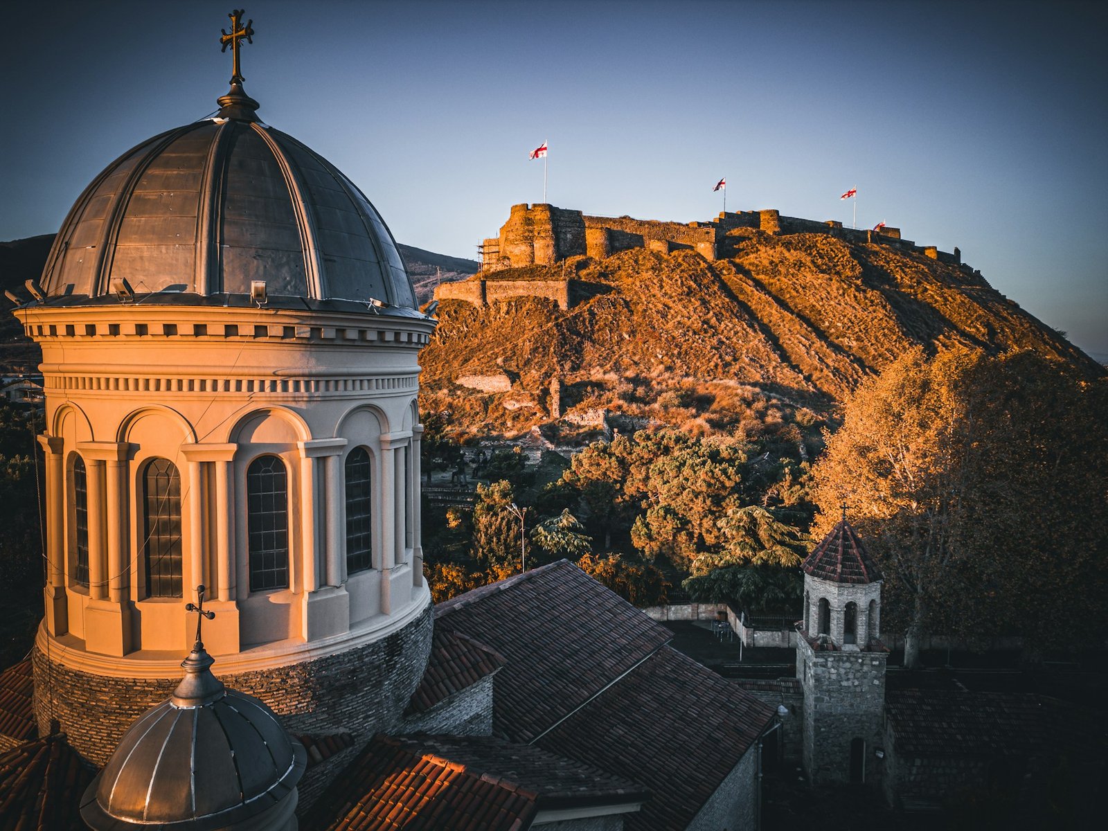
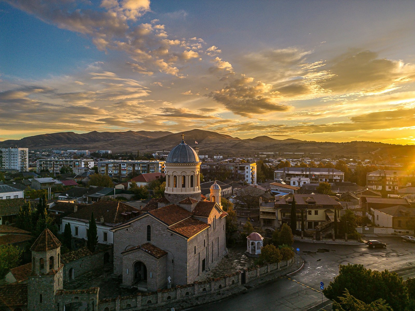
Gori Fortress — Why the hill mattered
The fortress is not just Gori’s postcard landmark; it is the key to the whole urban logic. Perched on a rocky outcrop above the city, it commands views over routes, fields, and river space in multiple directions. Much of what visitors see today reflects later rebuilding, especially from the early-modern period, but the site’s defensive importance is much older. In other words, the fortress was never ornamental first. It was there because this hill mattered.
Early-Modern to Imperial Gori
In the early-modern centuries, Gori sat inside the pressure zone between larger imperial forces. Ottoman and Safavid influence moved across Kartli repeatedly, and Gori felt that instability directly through occupation, assault, and reconstruction. Yet the city also remained commercially useful, which is why it recovered again and again instead of fading into a ruined frontier outpost.
By the 18th century, Gori had regained urban weight as a regional center after repeated setbacks. Markets, religious communities, and administrative functions kept it alive, while royal rebuilding efforts helped restore the urban skeleton around the fortress. When Russian imperial rule later formalized power in Georgia after 1801, Gori was already more than a military site. It was a working provincial city with older layers still visible beneath the new order.
A small but revealing religious layer
One of the more interesting side stories from early-modern Gori is the record of Catholic missions and church-building attempts. These communities never redefined the city, but they show that Gori was connected enough to attract outside religious actors and to leave a paper trail beyond Georgian court and fortress history. It is a small detail, but it helps place Gori inside wider regional currents rather than treating it as a purely local stronghold.
Tsarist Gori, 1905 Unrest & Local Culture
Under Tsarist rule, Gori developed the profile of a district city: schools, churches, civic institutions, workshops, and a public life that tied it to wider Georgian intellectual currents. It was not Tbilisi, but it was far from passive. The town had enough cultural and political energy to become part of the wider ferment of late imperial Georgia.
The unrest of 1905 reached Gori as it did much of the empire. Meetings, agitation, student activity, and local political mobilization all appear in accounts of the period. That matters because it places Gori inside the social climate that shaped revolutionary biographies, including Stalin’s. The city was not simply the backdrop to one future dictator’s childhood; it was a place already touched by the sharper politics of the age.
Stalin in Gori — Birthplace, Schooling & Legacy
Gori’s global notoriety comes from one fact above all others: Joseph Stalin was born here. His early years in the city, his church-school education, and his later departure toward Tiflis and the wider revolutionary world gave Gori a symbolic weight far larger than its size. That association still shapes how outsiders approach the city, even though it risks flattening everything else Gori is.
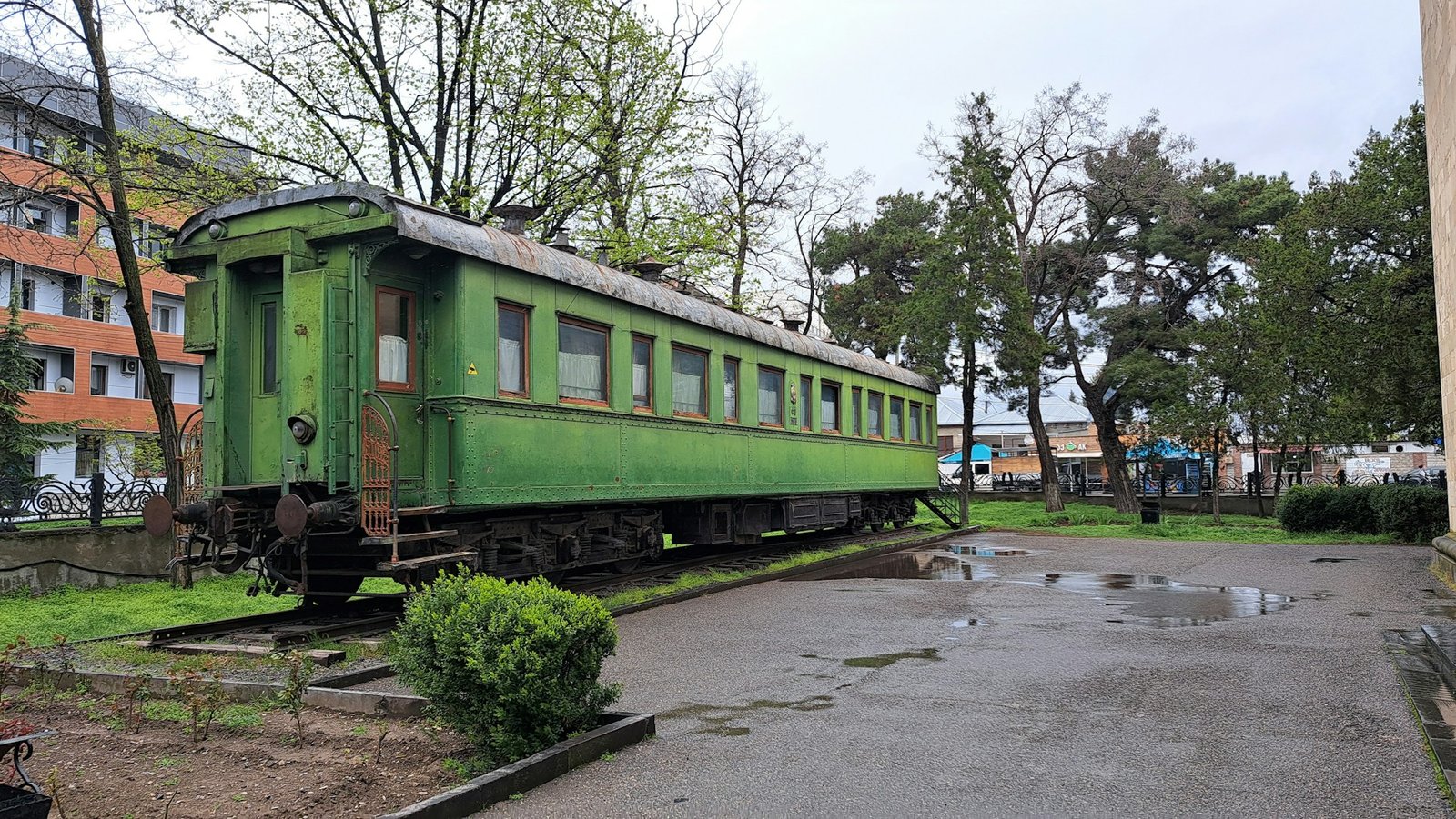
The Joseph Stalin State Museum remains the clearest expression of that legacy. The complex includes the preserved birth house, the main museum building, and Stalin’s rail carriage, and it still carries a distinctly Soviet-era tone in how memory is framed. That is part of what makes it compelling: visitors are not only seeing artifacts, but also seeing how Georgia has wrestled, and in some ways still wrestles, with the presentation of Stalin’s past. The museum’s official pages currently list daily hours of 10:00–18:00, a shorter 10:00–17:00 winter schedule from November 1 to April 1, and a standard 15 GEL fee for the full guided complex, with separate or reduced rates for other categories.
Soviet & Post-Soviet Gori: Quake, War & Recovery
The modern cityscape owes much to rupture. A major 1920 earthquake damaged large parts of old Gori, and Soviet planning afterward reshaped the city with broader streets, newer public buildings, and a more regular urban texture. In the Soviet decades, industry and regional agriculture helped sustain the local economy, even as Stalin’s birthplace became a formal site of state memory.
After Georgia’s independence, Gori felt the same pressures that hit many post-Soviet regional cities: industrial decline, economic strain, and demographic contraction. Then came the August 2008 war, which returned Gori to global headlines and underlined how exposed its location could still be. Yet the city did not freeze there. In the years since, Gori has continued to function as a regional center with renewed public spaces, active domestic tourism, and a stronger heritage profile than many outsiders expect.
A short historical timeline
| Period / year | Why it matters |
|---|---|
| Bronze and Iron Age background | Early settlement roots in the wider area |
| Early medieval era | Fortified hill gains durable strategic role |
| 12th century | Gori emerges more clearly as a recognized town in Georgian state space |
| 13th–18th centuries | Repeated invasions, occupations, rebuilding, and urban recovery |
| 1801 onward | Russian imperial rule formalizes Gori’s provincial-administrative role |
| 1878 | Birth of Stalin in Gori |
| 1905 | Political unrest reaches the district |
| 1920 | Earthquake damages the old town |
| 1957 | Stalin Museum complex opens in its mature Soviet form |
| 2008 | War again exposes Gori’s strategic location |
Landmarks & How to Visit
Gori works best as a city you walk first and interpret second. The center is compact enough to connect the fortress, the Stalin Museum, and the main civic core without much effort. From there, short drives open up the wider landscape that explains why Gori matters.
Gori Fortress
If you only have time for one elevated viewpoint, make it the fortress. The site gives you the city’s spatial logic in a few minutes: hill, routes, plain, river corridor, and the built-up core beneath. It is also the clearest corrective to the idea that Gori begins and ends with Stalin.
Joseph Stalin State Museum
This is the city’s most internationally recognizable stop. Go for the obvious reason if you must, but pay attention to the framing as much as the collection. The museum is not interesting only because of Stalin himself; it is interesting because it shows how a post-Soviet society still lives with the material remains of Soviet hero-making. Official museum information currently lists daily opening and posted fee categories on the museum’s own pages.
Uplistsikhe Cave Town
Uplistsikhe is the strongest half-day extension from Gori. Georgia Travel places it about 10 km from the city, while UNESCO’s Tentative List entry describes the site east of Gori on the left bank of the Mtkvari and identifies it as a major ancient religious, political, and cultural center. That makes Uplistsikhe more than a scenic add-on; it is part of the same regional story of settlement, defense, and continuity.
Ateni Sioni & the wider Gori landscape
Ateni Sioni adds a different register to the area: less urban, more ecclesiastical, and more closely tied to the gorge landscape south of the city. Taken together, Ateni, Uplistsikhe, the fortress, and the Stalin Museum show why Gori is best understood as a regional historical node rather than a single-site stop.
Practical logistics
From Tbilisi: Gori is an easy day trip or overnight stop by road and rail. On foot: the central core is manageable. For nearby sites: taxis or a driver make Ateni and Uplistsikhe much easier. Best season: spring and autumn are the most comfortable for walking and open-site visits. In high summer, the exposed rock at Uplistsikhe and the fortress slopes can feel much hotter than the city streets.
FAQ
Is Gori only worth visiting because of Stalin?
No. Stalin is the reason many people know the name, but Gori is also a fortress city with a strong geographic position, a layered medieval and early-modern history, and easy access to sites such as Uplistsikhe and Ateni Sioni.
How far is Gori from Tbilisi?
It is close enough for a day trip from the capital and usually thought of as roughly an hour west of Tbilisi by the main corridor, depending on traffic and mode of travel.
Why was Gori strategically important?
Because it sits in central Kartli below a defensible hill and along one of Georgia’s key east–west routes. The fortress, the plain, and the river setting all made it valuable for movement, defense, and control.
What happened to Gori in 2008?
The city was caught up in the August 2008 war, which reminded everyone that Gori’s location is not just historically strategic but politically sensitive in the present as well.
What is the best nearby site besides the Stalin Museum?
For most visitors, it is Uplistsikhe. It gives the wider Gori area a much deeper time horizon and shows how this part of Georgia held urban, ritual, and defensive importance long before the modern city took shape.
What Did We Learn Today?
Gori matters because several Georgian stories meet in one place: fortress geography, Kartli state-building, imperial pressure, Soviet memory, post-2008 vulnerability, and the stubborn continuity of a city that keeps being read through Stalin even though its real significance is much wider than one biography.
Sources & Data Notes
For this Gori piece, I cross-check the stable anchors first — location, fortress setting, nearby heritage context, and the city’s broader historical profile — using standard statistical and reference material, Georgia travel/heritage pages, UNESCO material where relevant, and official museum information for practical details that can change. Figures are rounded where that makes more sense than false precision, and newer schedules, fees, or releases can shift some specifics without changing the core geography or history. Some visuals on GeographyPin may be AI-assisted, especially simplified illustrative ones, but the framing, structure, and editorial judgment are still shaped manually.