France is often pictured as a roughly hexagonal outline in western Europe. That image leaves out Corsica and the Republic’s overseas territories, while saying little about the landscapes inside it. A more useful geographic picture connects the Paris and Aquitaine basins, central uplands, mountain margins and rivers leading toward different seas.
Metropolitan France comprises the European mainland and Corsica, while the French Republic also includes overseas territories. Its European landscapes range from sedimentary basins and Atlantic-facing lowlands to the Massif central, Alps and Pyrenees. Rivers connect these contrasting regions to the Channel, Atlantic and Mediterranean; national statistics must identify which territories they include.
How to use this article: Clarify territorial scope, distinguish two meanings of basin, or explore Lyon’s river junction.
1. Locate the European mainland without losing sight of overseas France
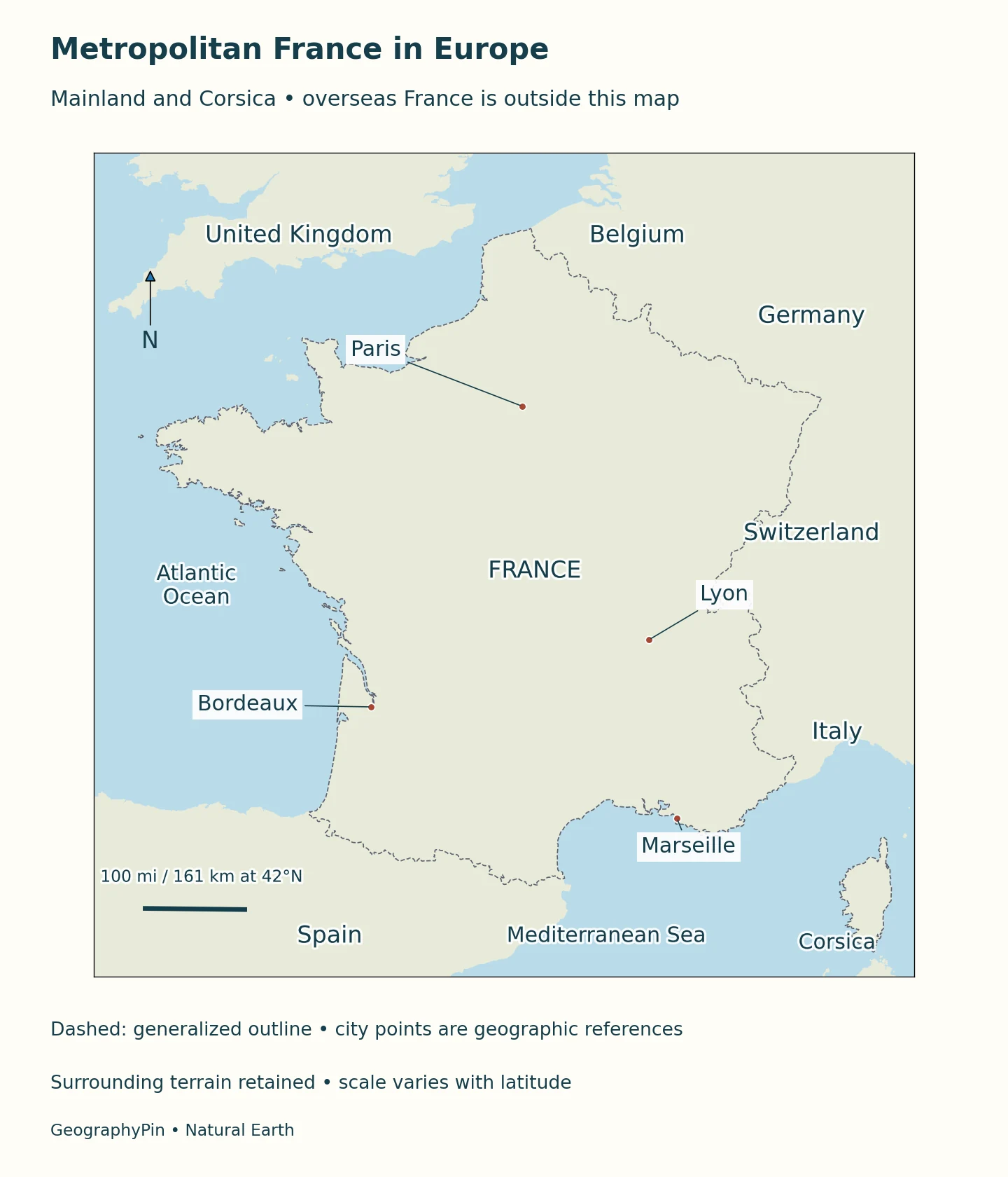
The European mainland lies between the English Channel and North Sea to the north, the Atlantic to the west and the Mediterranean to the southeast. Its land neighbors are Belgium, Luxembourg, Germany, Switzerland, Italy, Monaco, Spain and Andorra. This is a list of European neighbors, not a count of every land border involving French territory worldwide.
Corsica belongs within metropolitan France even though it is an island. “Metropolitan” therefore does not mean “mainland only.” The distinction matters whenever a map, population table or description uses one of these terms: a mainland map can be useful, but its geographical coverage is narrower than a metropolitan total.
Which France does the figure describe?
INSEE distinguishes metropolitan France from the overseas departments and regions, commonly abbreviated DROM. The five territories in that statistical group are Guadeloupe, Martinique, French Guiana, Réunion and Mayotte. Other overseas territories have different administrative arrangements and are not automatically included in a statistic covering metropolitan France plus the DROM. “Overseas France” and “the five DROM” are consequently not interchangeable labels.
The overseas setting also changes the border picture. French Guiana is on the South American mainland, adjoining Brazil and Suriname. On the Caribbean island of Saint-Martin, the French territory adjoins Sint Maarten, part of the Kingdom of the Netherlands. These connections are absent from a map showing only European France.
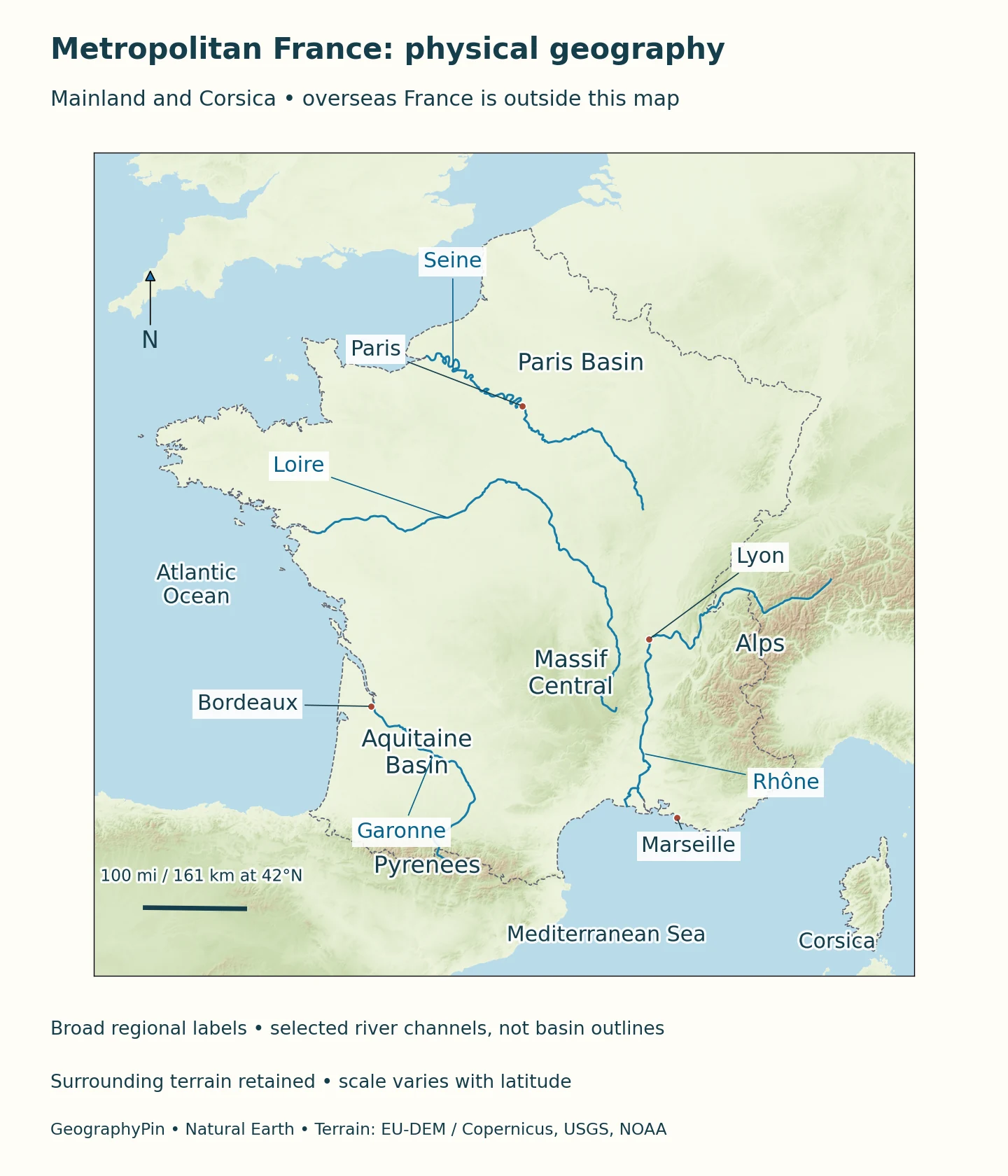
The maps below focus on metropolitan France, including Corsica. They show the European physical setting rather than the full territorial extent of the Republic.
2. Put dates and territorial coverage beside the country facts
Paris is the capital. For other national capitals, see the world capital cities reference. French is the language of the Republic under Article 2 of the Constitution; that legal designation does not describe every language used in homes and communities. France is also a member of the European Union, but European membership and metropolitan geography are different categories.
INSEE’s September 2026 publication estimated 69.1 million residents on January 1, 2026: 66.8 million in metropolitan France and 2.3 million in the DROM. Those rounded figures share the same reference date and publication vintage. They should not be relabeled as a count covering every territory of the Republic. Area totals also depend on territorial coverage: a metropolitan land-area figure cannot represent the Republic’s geographically dispersed territories worldwide.
| Item | Fact | Date or scope |
|---|---|---|
| Capital | Paris | European Union country profile |
| Language of the Republic | French | Constitution, Article 2 |
| Population | 69.1 million | January 1, 2026; metropolitan France plus DROM |
| Metropolitan component | 66.8 million | Same INSEE estimate, including Corsica |
| DROM component | 2.3 million | Same INSEE estimate; five-territory statistical group |
3. Read sedimentary basins beside the central uplands
The Paris Basin is a geological region whose sedimentary rocks record a history much older than the city. Its boundary extends well beyond Paris and is not the boundary of the urban area.
In the southwest, the Aquitaine Basin opens toward the Atlantic. Sediments accumulated from surrounding uplands over long periods, while deformation associated with the Pyrenees affected its southern part. Its surface is not uniformly flat, and its geological outline is not identical to the area drained by the Garonne.
Brittany offers a different geological setting from the sedimentary basins. It belongs to the Armorican Massif, whose old bedrock includes granite, gneiss and schist. Water below ground depends not only on the rock type but also on weathering and fractures. The contrast with sedimentary basins helps explain why neighboring regions can store and transmit groundwater differently.
Two meanings of basin
A sedimentary basin describes a geological setting where material has accumulated. A drainage basin is the land contributing water to a river system. The first concerns rocks and geological history; the second concerns water connections. They can overlap, but one boundary cannot simply substitute for the other. This distinction is particularly useful around Paris and Bordeaux, where familiar basin names can obscure what a map actually represents.
Farther inland, the Massif central contains a varied succession of uplands, plateaus and deeply cut valleys. In Auvergne-Rhône-Alpes, it lies west of the Rhône corridor, while the Alps rise to the east. The corridor and intervening plains help connect places separated by much higher terrain. A label such as “central uplands” is an orientation aid, not a claim that this whole region has one height or one landform.
4. Follow rivers toward the Channel, Atlantic and Mediterranean
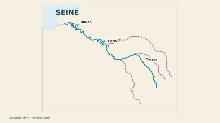
The Seine begins at Source-Seine on the Langres plateau and reaches the English Channel between Le Havre and Honfleur. Paris lies along this river system; the Yonne, Marne and Oise are important tributaries. The Seine’s drainage basin should not be confused with the larger Seine-Normandy water-management area, which includes other coastal catchments.
The Loire provides another route across the mainland. It begins at Mont Gerbier de Jonc and reaches the Atlantic at Saint-Nazaire. Its estuary is a meeting place of river water and seawater, not simply a freshwater channel extending unchanged into the ocean. Looking downstream therefore involves both a river network and a coastal transition.
The Garonne starts in Spain and crosses into France. It meets the Dordogne at the Bec d’Ambès, forming the Gironde estuary. The Garonne and Gironde are connected but are not interchangeable names for the same entire watercourse. Bordeaux’s setting makes more sense when the river, its tributaries and the estuary are read together.
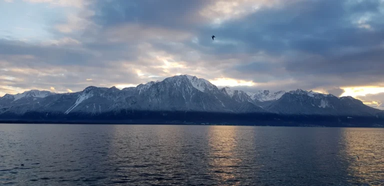
The Rhône begins in Switzerland, passes through Lake Geneva, also called Lac Léman, and continues through France to the Mediterranean. Its international headwaters are a reminder that national borders do not contain complete river systems. A river labeled on a country map may receive water from outside that country and connect several different landscapes.
A city at the meeting of two rivers
Lyon stands where the Saône joins the Rhône. Its Confluence district occupies land between the two waterways, giving an unusually clear urban example of a river junction. The contrast with a coastal gateway such as Le Havre is useful: both connect transport routes, but one sits at an inland confluence and the other beside the sea.
5. Compare mountain margins with Corsica’s short routes to the sea
The Alps and Pyrenees give the European mainland major mountain margins, but mountains are not continuous walls without openings. Valleys, passes and engineered connections influence how people move through them. In the Alps, the contrast between high terrain and deep valleys is especially important: a short line across a map may cross much more relief than a longer journey following a valley.
Corsica compresses a different mountain-and-coast relationship into an island. The regional prefecture describes a strongly dissected landscape of ridges, slopes and gorges. Many watercourses are comparatively short because the sea lies close to the mountain interior. This differs from a large mainland river gathering tributaries across an extensive basin before reaching its estuary.
The eastern plain and local coastal basins add variety to Corsica’s mountain-dominated interior. “Mediterranean island” should not be read as a synonym for flat beach country. On a relief map, follow the transition from the shoreline into the ridges rather than using the island’s outline alone to imagine its terrain.
6. Compare regional climates rather than applying one national average
Météo-France distinguishes five broad climate types in the European mainland and Corsica: oceanic, transitional oceanic, semi-continental, mountain and Mediterranean. Atlantic-facing areas experience maritime influence, while the interior generally has greater seasonal temperature contrasts. Paris illustrates the transitional oceanic category, not an exclusively continental climate.
Mediterranean conditions characterize the southeast and Corsica, while elevation and exposure create strong local variation in mountains. A coastal city and a high valley at a similar latitude need not experience similar weather. These categories describe broad patterns, not precise lines on the ground or forecasts for a particular visit.
The scope is important again: this European climate outline is not a classification of all overseas France. Nor does a single wet month establish a new regional climate. Climate descriptions draw on distributions and longer records; daily weather concerns conditions at a particular place and time. A country profile provides orientation, while current forecasts require a more local view.
7. Connect cities, ports and economic corridors
Paris offers a clear example of why settlement geography needs more than a dot on a map. It is the national capital and a city on the Seine, but the municipality, surrounding urban development and wider region are distinct units. Their populations and economic indicators cannot be swapped without changing the question being answered.
The Seine corridor links inland and maritime transport. HAROPA describes maritime terminals at Le Havre and Rouen alongside river terminals serving the Paris region. The geographical relationship is more informative than a port ranking without a date: cargo connections involve coastal gateways, river facilities and an inland hinterland rather than a single isolated point.
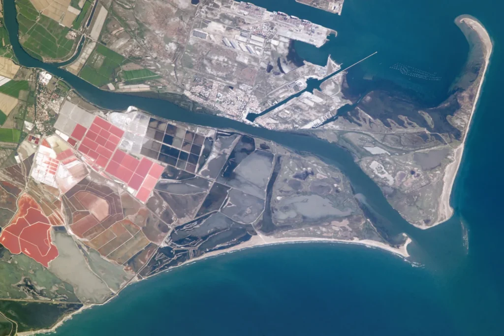
The Mediterranean side provides a different example. The Marseille Fos port system includes western facilities at Fos connected to the Rhône–Saône inland waterway network. This links the coast with places such as Valence and Lyon. It does not mean that every terminal is in central Marseille or that a river corridor and a municipality share the same boundaries.
The Seine-Normandy landscape is agricultural as well as urban. Extensive arable farming occupies much of its cultivated land, while livestock farming and mixed systems add variety. Champagne and Chablis vineyards form distinctive landscapes in the east of the basin.
What Did We Learn Today?
France’s geography is clearer when territorial scope comes first: metropolitan France includes Corsica, while national statistics may cover only a specified overseas group. Sedimentary basins differ from river catchments, and mainland rivers lead toward different seas. Mountain margins, island relief, regional climates and transport corridors then help explain the contrasting settings of cities and landscapes.
Sources & Data Notes
The January 1, 2026 population estimate uses INSEE’s September 2026 publication and covers metropolitan France plus the five DROM, not every overseas territory. Rounded components use the same publication vintage. Maps cover metropolitan France including Corsica, not the full Republic. Natural Earth supplies generalized geographic outlines, selected river channels and city reference points. Dashed outlines follow its cartographic convention rather than a legal boundary survey. Broad basin labels are not catchment polygons. Actual Mapzen elevation shading uses source terrain including EU-DEM, USGS SRTM/GMTED2010 and NOAA ETOPO1. Produced using Copernicus data and information funded by the European Union – EU-DEM layers. Colors represent relief, not snow or vegetation. The Mercator scale bar is referenced to 42°N and varies with latitude. The featured photograph shows the Grand Rhône mouth on July 14, 2017, not current conditions. Image courtesy of the Earth Science and Remote Sensing Unit, NASA Johnson Space Center (ISS052-E-15820); converted to WebP without changing the scene.
- INSEE September 24, 2026 demography
- INSEE border page
- Official territorial regional park
- France Diplomatie Netherlands bilateral
- EU country profile
- Constitution Article 2
- BRGM Paris Basin
- SIGES/BRGM Aquitaine
- Regional prefecture Auvergne-Rhône-Alpes
- Seine agency
- GIP Loire
- Natura2000 Garonne, 2013
- CNR Rhône
- Corsica prefecture
- Météo-France
- HAROPA
- Marseille Fos
- INSEE: definition of metropolitan France
- INSEE: overseas France definitions
- BRGM/SIGES: Brittany geology and groundwater
- Métropole de Lyon: the Confluence district
- NASA: Rhône River delta photograph and acquisition details
- NASA: astronaut photograph reuse conditions
- Natural Earth: public-domain geographic data terms
- Mapzen terrain: required source attribution