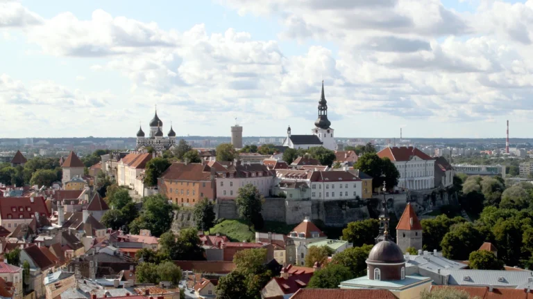
Estonia’s geography changes noticeably between the islands off its western coast, the limestone landscapes of the north and the wooded hills of the southeast. Water is the connecting theme: the Baltic Sea, large border lakes, smaller glacial lakes and peat-forming wetlands shape both the landscape and the routes between settlements.
Estonia is a Northern European country on the eastern side of the Baltic Sea. Tallinn is its capital. The country includes the large western islands of Saaremaa and Hiiumaa, extensive lowlands, bogs and southern uplands. It is one of the three Baltic states and also participates in Nordic-Baltic cooperation.
How to use this article: Clarify Baltic and Nordic connections, compare the main landscapes, or explore how raised bogs work.
1. Locate Estonia between the Baltic Sea and Lake Peipus
Estonia borders Latvia to the south and Russia to the east. The Gulf of Finland lies to the north, separating its northern coast from Finland, while the Baltic Sea opens westward. Tallinn stands on the northern coast rather than in the center of the country.

The western islands are part of Estonia, not separate countries. Saaremaa lies south of Hiiumaa; both are substantial land areas rather than tiny offshore rocks. On the eastern side, Lake Peipus, also called Peipsi, is shared with Russia. Land borders, open sea and lake shores therefore all matter when locating Estonia.
Baltic geography and Nordic connections can coexist
Estonia, Latvia and Lithuania are commonly grouped as the three Baltic states. That geographic and political grouping does not mean their languages belong to one family or that their cultural connections are identical.
Estonia also works closely with Nordic countries. The Nordic-Baltic Eight, or NB8, brings together the five Nordic countries and the three Baltic states in an informal cooperation format. Membership in that group does not turn Estonia into a Nordic state for every classification. “Baltic country with Nordic connections” is a useful way to avoid treating overlapping regional identities as a contradiction.
Our Baltic countries map places the three states together, while the Baltic Sea guide explains their wider maritime setting.
2. Country facts and dated population
| Item | Fact | Date or meaning |
|---|---|---|
| Capital | Tallinn | Northern coastal capital |
| Population | 1,360,745 | Resident population at January 1, 2026; revised Statistics Estonia release of April 21, 2026 |
| Area | About 17,504 sq mi (45,336 km²) | Geographical size published in the EU country profile, attributed to Eurostat 2026 |
| Official language | Estonian | Constitutional language; not a statement that all residents share one mother tongue |
| Currency | Euro (EUR) | Euro-area member since 2011 |
| Government | Parliamentary republic | Prime minister heads the government; president is head of state |
| Local government | 78 local authorities | 15 towns and 63 rural municipalities; one local-government tier |
Residents are not the same as citizens
The population figure includes resident Estonian citizens, foreign nationals and stateless people. The statistical definition covers people who have lived in Estonia for at least a year or intend to do so. It is therefore not a count of Estonian passport holders worldwide.
The April 2026 release revised the initial population figure using additional migration information. It records a decline during 2025, with both natural change and net migration contributing. A revised annual population figure should not be confused with a fresh census conducted on that reference day.
The area figure describes the country as a whole, including its islands. Published geographic-area series can differ slightly because of source and measurement conventions; the figure here retains its stated source rather than mixing it with an island count or a coastline measurement.
3. Islands, lowlands and southern uplands
Compare the main physical landscapes
| Setting | Location | Geographic character |
|---|---|---|
| Western islands and coast | Saaremaa, Hiiumaa and neighboring coastal areas | Low coastal landscapes, channels and island settlements separated by water |
| Northern limestone landscapes | Along and inland from the Gulf of Finland | Bedrock escarpments and limestone exposures interrupt generally modest relief |
| Interior lowlands and wetlands | Across lower-lying inland areas | Forests, farmland, peatlands and lakes form a varied mosaic |
| Southern uplands | Including the Haanja area in the southeast | Glacially shaped hills, valleys and lakes; more rolling terrain than the coastal lowlands |
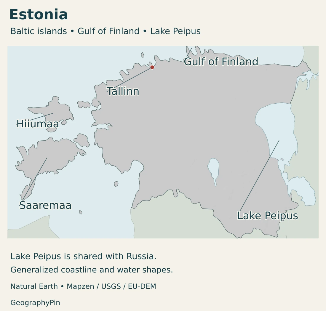
These settings overlap rather than forming four sharply bounded administrative zones. A lowland can contain a raised bog, a town and cultivated land; an upland can include both hilltops and wet valley bottoms. Estonia is a low-relief country, but “low” should not be mistaken for uniformly flat.
Ice and bedrock leave different signatures
Glacial landforms help explain the rounded hills and valleys of the Haanja uplands. Farther north, the North Estonian Klint exposes a limestone escarpment. Sandstone cliffs at Taevaskoda and the streamlined glacial hills of Vooremaa provide other examples of how bedrock and ice history produce different local landscapes.
A national relief map shows the broad contrasts, but a small cliff or narrow valley may be important on the ground without dominating the country-wide image. Relief shading indicates the form of the terrain, not a separate mountain range wherever the shading becomes darker.
Saaremaa and Hiiumaa add a maritime dimension
Saaremaa is Estonia’s largest island. Connections through Muhu link it with the mainland ferry route, illustrating how a journey can combine sea crossings, islands and roads rather than following a single continuous mainland corridor. Hiiumaa forms another major island landscape to the north.
Island communities have the same national institutions and currency as the mainland, but their transport geography differs. Water gaps influence the movement of people and supplies, while coastal landscapes support recreation and local services. A place that looks close on a small map may still require a crossing rather than a direct drive.
4. Bogs, lakes and the maritime climate
A raised bog depends on water, not just wet soil
Peat forms where waterlogged conditions slow the decomposition of plant remains. In a raised bog, accumulated peat can separate the rooting zone from mineral-rich groundwater. Rainfall then becomes especially important, creating acidic, nutrient-poor conditions unlike those of many surrounding soils.
Mukri Nature Reserve provides a concrete example of this landscape. Its bogs and wooded margins show that a peatland is not simply an empty lake bed or a forest with puddles. Changes to drainage can alter the conditions that allow peat to accumulate.
Restoration projects in Estonia have blocked drainage channels to help re-establish mire hydrology. This connects conservation with water management: restoring a wetland involves the movement and retention of water as well as the plants visible at its surface.
Large lakes and small basins have different roles
Many Estonian natural lakes have a glacial origin, but others formed in coastal settings, peatlands or karst landscapes. Their distribution is uneven. The southern uplands and western coastal areas offer different lake environments, so a national lake count alone says little about the landscape around a particular settlement.
Peipsi-Pihkva is a connected lake system with three main parts, including Peipus proper, the narrower Lämmijärv and Lake Pskov. The Narva River is its outlet. Its catchment extends beyond Estonia, making water quality a shared basin issue rather than something determined only by the Estonian shoreline.
Nutrients entering a lake can encourage eutrophication, or excessive biological production. The source of those nutrients may be well away from the shore. This is why a drainage basin is often a more useful unit for understanding lake management than a line around the water itself.
The coast moderates a more continental interior
Estonia lies in a transition between maritime and continental climate influences. The Baltic Sea moderates coastal conditions, while inland locations experience a stronger continental influence. Atmospheric circulation also matters, so coast-versus-interior is a broad pattern rather than a precise forecast for every day.
The distinction helps explain why an exposed island site and an inland town can experience different conditions within a relatively small country. Local terrain, shelter and proximity to water add further variation. Long-term climate describes recurring tendencies; individual seasons can differ substantially.
5. Tallinn, Tartu and everyday languages
A coastal capital and an inland university city
Tallinn combines the seat of national government with a Gulf of Finland location and maritime connections. The capital is a city, while its wider commuting and economic connections extend beyond the municipal boundary. City, county and national population figures therefore describe different areas.
Tartu offers a contrasting inland setting on the Emajõgi River. Its university gives education and research a prominent role in the city. Comparing Tallinn and Tartu makes Estonia’s settlement geography more informative than treating every important activity as an extension of the capital.
Estonian is not a Baltic language in the linguistic sense
Estonian is the official language and is closely related to Finnish. Its linguistic relationship is different from the geographic label “Baltic state.” A country can belong to the Baltic regional grouping without its main language belonging to the Baltic language family.
Official-language status also differs from the languages people use at home, at work or with relatives. Estonia’s resident population is not defined by a single citizenship or mother tongue. Keeping language, nationality and residence separate makes both demographic figures and regional identities easier to understand.
6. Institutions, ports and regional connections
National institutions and one-tier local government
Estonia is a unitary parliamentary republic. The prime minister leads the government, while the president is head of state. Local authorities handle local responsibilities within that national framework rather than operating as constituent sovereign states.
The local-government system has one tier, with town and rural municipalities holding the same legal status. Their names describe the type of local authority, not a hierarchy in which rural municipalities are subordinate to towns. This distinction matters when comparing an urban settlement with the larger administrative area surrounding it.
Passenger harbors and cargo terminals serve different networks
Maritime geography links Estonia’s economy to the Baltic region. The Port of Tallinn organization operates distinct passenger and cargo harbors rather than one interchangeable waterfront. Old City Harbour serves passenger connections, while Muuga and Paldiski South handle cargo functions.
Muuga’s activities include containers, bulk cargo and other freight. These functions connect maritime routes with inland transport and industrial sites. A harbor’s importance therefore depends on its connections and facilities, not simply on how close it lies to the historic center of Tallinn.
An interconnected country, not a single landscape
Ferry links, ports, inland cities and wetland conservation reveal different ways geography influences daily life. Sea crossings shape island access; university activity gives an inland city a distinct role; shared lake basins connect environmental decisions across borders.
Estonia’s small size does not erase these differences. Its geography is best understood as a set of connected coastal, island and inland environments. For the country’s place in the wider region, see our European countries and capitals guide.
Frequently Asked Questions
Is Estonia Baltic or Nordic?
Estonia is one of the three Baltic states. It also participates in Nordic-Baltic cooperation and has close connections with Nordic countries; these descriptions refer to different regional relationships.
Are Saaremaa and Hiiumaa separate countries?
No. They are islands belonging to Estonia. Their sea crossings and coastal settings distinguish them geographically from the mainland, not politically as independent states.
Is Lake Peipus entirely in Estonia?
No. Lake Peipus, also called Peipsi, is shared with Russia. Its larger connected lake system and international catchment make water management a cross-border issue.
What Did We Learn Today?
Estonia combines western islands and a Baltic coastline with lowlands, peatlands, large eastern lakes and southern uplands. Tallinn’s maritime role differs from inland Tartu, while Baltic geography coexists with Nordic connections. Dated resident-population figures, clearly sourced area measurements and the distinction between physical landscapes and local authorities keep that country profile precise.
Sources & Data Notes
Statistics retain their stated reference dates and definitions. Area series may differ slightly between publications; no coastline length, exhaustive island count or population density is derived here.
- Estonian Health Board: Peipsi catchment profile: Pages 11–12 describe the shared three-part lake system and Narva outlet. Reviewed in 2020; used for stable geography, not current bathing-water conditions.
- Statistics Estonia: revised population, April 21, 2026: January 1, 2026 resident population, including revised migration information.
- Statistics Estonia: population definition: Residence rather than citizenship; at least one year of actual or intended residence.
- European Union: Estonia country profile: Geographical size of 45,336 km² attributed to Eurostat 2026, capital, parliamentary government and euro. The area is not presented as a separately measured dry-land figure.
- Ministry of Regional Affairs and Agriculture: local governments: Current 78 local authorities and the equal status of town and rural municipalities.
- President of Estonia: Constitution: Stable constitutional provisions on the republic, unitary state and official language.
- Estonian Ministry of Foreign Affairs: NB8: Five Nordic and three Baltic countries in an informal cooperation format.
- Visit Estonia: islands: Saaremaa, Hiiumaa and island connections; no exhaustive island count is used here.
- Environmental Board: Haanja Nature Park: Glacially shaped hills and valleys in the southern uplands.
- Estonian Nature Information: geological treasures: Limestone and sandstone exposures, glacial landforms and regional examples.
- Environmental Board: Mukri Nature Reserve: Peat formation and the water and nutrient conditions of raised bogs.
- European Commission: Estonian mire restoration: March 2024 account of drainage blocking and habitat restoration.
- Estonian Environment Portal: inland waters: Lake origins and uneven distribution; broad hydrological geography.
- Estonian Nature Information: Lake Peipsi: Connected lake system, Narva outlet and nutrient pressures. Historical condition observations are not a current water-quality assessment.
- Lakson, Post and Sepp: Estonian climate research: 2019 primary research supporting maritime–continental contrasts; no historical trend is presented as a current forecast.
- University of Tartu: city setting: Tartu on the Emajõgi and its university setting; travel schedules and prices are outside this profile.
- Study in Estonia: language: Estonian’s relationship to Finnish and distinction from neighboring languages.
- Port of Tallinn: harbors: Distinct passenger and cargo functions, including Muuga and Paldiski South.
Map sources and scope: Original GeographyPin maps use Natural Earth country, lake and populated-place data. Natural Earth data are public domain. All source island components are retained at the same scale as the mainland. The generalized coastline is not an exhaustive small-island inventory or official boundary survey; it shows the modern country rather than the 1920 Treaty of Tartu boundary. Geographic naming and context also use the PCGN January 2024 factfile.
Tallinn uses Natural Earth city-coordinate attributes. Island leaders locate source land, not municipal boundaries. The complete source Lake Peipus shape is retained across the border; no precise division of its waters is asserted. Water polygons are generalized historical geometry, not observations of current shorelines.
Hillshade is calculated from genuine elevations accessed through Mapzen Terrain Tiles, without vertical exaggeration. Global elevation data courtesy of the U.S. Geological Survey. Produced using Copernicus data and information funded by the European Union – EU-DEM layers. Elevation-source attribution and terms apply. Shading represents terrain form, not bathymetry or numerical elevation bands.
The cover uses Estonia flag artwork by SKopp, PeepP and contributors. The intact 11:7 flag appears separately from the decorative country-outline motif.