Ellis Island is a federally owned historic island in New York Harbor, with territory in both New York and New Jersey. Its unusual boundary makes sense only when the original island, later land reclamation and federal ownership are considered separately.
One island, two state jurisdictions
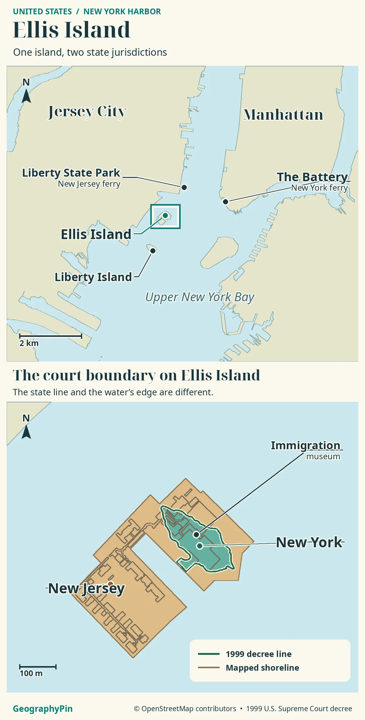
Ellis Island lies beside Jersey City in New York Harbor, but it is not wholly in New Jersey. New York retains the historically defined island area; New Jersey contains most later additions. The Supreme Court’s final survey, rather than today’s shoreline or a museum address, defines the division.
How to use this article: First separate the three harbor locations, then read the surveyed boundary and identify the visitor crossing.
Ellis Island on a New York Harbor map
Ellis Island lies beside the New Jersey shore of New York Harbor, across the water from Lower Manhattan. Liberty Island, home of the Statue of Liberty, is a separate island to its south. Liberty State Park is on the mainland at Jersey City, not on either island.
Three places with different roles
The useful starting point is the water between them: Ellis is the immigration museum island; Liberty is the statue island; the mainland park is one departure point for the authorized visitor ferry. A sightseeing photograph that includes the Statue of Liberty does not mean the statue stands on Ellis Island.
The original island and the 1834 agreement
The two-state arrangement predates the immigration station. An 1834 compact put the general New York–New Jersey boundary in the middle of the Hudson River and harbor, but preserved New York’s jurisdiction over Ellis Island. New Jersey retained sovereignty over the submerged land on its side of the boundary.
That exception is why proximity alone gives the wrong answer. The island could be close to New Jersey without the original island becoming New Jersey territory. A modern map needs both the broad harbor boundary and the smaller exception around Ellis.
The distinction became important when the federal government made the island much larger. Where there had been water over New Jersey’s submerged land, engineers created dry land around the New York island.
Reclaimed land and the 1998 decision
On May 26, 1998, the Supreme Court ruled in New Jersey v. New York that the later artificial enlargement belonged to New Jersey. Filling the surrounding water did not carry New York’s sovereignty outward with the new shoreline. The Court treated this artificial addition differently from gradual natural accumulation.
This is the central explanation for a state boundary inside one small island: the physical coastline changed, while the legal division did not simply move to match it.
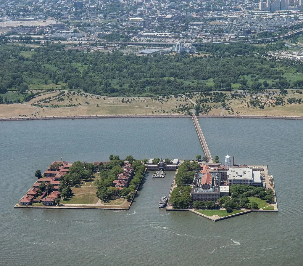
The construction history remains visible in the island’s layout. The original island was enlarged as Island 1, containing the main immigration building. Later projects added Islands 2 and 3 for hospital facilities. They were linked through narrow connections and developed around docking basins. The present complex is therefore not the outline of a single untouched natural island.
Reading the final surveyed boundary
The legal line is not a 3.3-acre sketch
The Court’s final decree of May 17, 1999 defines New York’s portion by the original island to its low-water mark, including a pier area on landfill as it existed in 1834, and by a specified survey. Consequently, “every piece of filled land is New Jersey” is too broad.
| Mapped territory | Acres |
|---|---|
| New York | 4.683 |
| New Jersey | 22.802 |
| Total | 27.485 |
These are the final map’s figures, not a new shoreline measurement. Its December 1, 1998 revision is based on a September 1995 survey. The familiar description of an original island of roughly 3.3 acres is not interchangeable with this mapped legal territory.
Use the final boundary map rather than a circle around the museum or the current seawall. An outline of dry land answers “where is the island?”; it does not by itself answer “which state is this part in?”
One federal historic site, not two separate parks
Federal ownership and state territorial jurisdiction answer different questions. Ellis Island remains federal property even though its ground lies within two states. The National Park Service manages the historic site as part of Statue of Liberty National Monument.
The immigration station operated from 1892 to 1954. Ellis Island entered the National Park System in 1965, and the restored museum opened in 1990. Its importance as an immigration landmark is shared across the whole site, rather than divided into a New York museum visit and a separate New Jersey island visit.
Nor does a state boundary tell visitors which buildings they may enter. The main museum and the former hospital areas have different visitor arrangements. A jurisdiction map is not an access map.
Crossing the harbor to Ellis Island
Choose a ferry departure, not a bridge route
The National Park Service’s visitor directions, checked on November 19, 2026, identify authorized Statue City Cruises ferries from The Battery in Manhattan and Liberty State Park in Jersey City. Both are mainland departure points for visiting the islands.
The service connection visible between Ellis Island and New Jersey is not a public walk-on approach. NPS says public access is by authorized ferry only and prohibits private vessels from docking. Do not turn a short-looking gap on a map into an assumed pedestrian crossing, kayak landing or private-boat route.
Check the park’s current directions and ferry information before setting out. A regional locator can show which shore to aim for, but it cannot establish that day’s sailings, security arrangements or last return departure.
Frequently Asked Questions
Can I leave luggage at Ellis Island?
NPS lists no storage facilities. Visitors must keep their belongings with them, so arrange any luggage storage before boarding rather than expecting lockers on the island.
Does a regular museum visit include the hospital buildings?
No. NPS directs visitors seeking access to the other buildings to the separately reserved Hard Hat Tour, which has its own restrictions. Check current tour information rather than assuming all structures shown on a map are open.
What Did We Learn Today?
Ellis Island’s shoreline and its state boundary tell different stories. Land reclamation enlarged the federal historic site without simply enlarging New York’s territory. The final surveyed division is the useful reference for jurisdiction; the authorized ferry is the practical reference for public access.
Sources & Data Notes
The boundary explanation uses the Supreme Court’s 1998 opinion and 1999 final decree, including the appended survey map. Acreages reproduce that historical map rather than a contemporary coast survey. National Park Service material supplies the island’s construction history, museum context and visitor guidance, checked November 19, 2026. Later official notices may change visitor arrangements.
- Supreme Court: New Jersey v. New York, 523 U.S. 767 (1998)
- Supreme Court: final decree and boundary survey, 526 U.S. 589 (1999)
- National Park Service: the three-island construction history
- National Park Service: Ellis Island FAQs
- National Park Service: visitor directions
- National Park Service: chronology
Map: GeographyPin original atlas. The New York polygon follows the 182 boundary calls in the 1999 final decree, including the historic pier area. Its geographic reconstruction is separate from the modern shoreline. Coastlines from OpenStreetMap land polygons and building outlines © OpenStreetMap contributors, ODbL, retrieved November 19, 2026. The map does not divide building interiors or establish visitor access.
Photograph: Ellis Island Complex, David.Clay.Photography, August 27, 2018, CC BY-SA 4.0. Resized and converted to WebP.