In the Tatras, a familiar lake name can point a traveler toward the wrong valley. Reading the full name alongside the surrounding peaks, neighboring lakes and approach paths is essential before interpreting a map of Czarny Staw Gąsienicowy.
Czarny Staw Gąsienicowy is a glacial lake in Poland’s Tatra National Park, in the Gąsienicowa Valley area near the Murowaniec hut. It is not Czarny Staw pod Rysami above Morskie Oko. Its full name, neighboring lakes and source-specific measurements are essential for identifying the right basin and approach.
How to use this article: Identify the correct lake, compare the elevation references, or distinguish the other Black Pond.
1. Which Lake Is Czarny Staw Gąsienicowy?
Czarny Staw Gąsienicowy is a natural lake in the Gąsienicowa Valley area of Poland’s Tatra Mountains, within Tatra National Park. The Polish name is often written without accents as Czarny Staw Gasienicowy. That spelling change does not identify a different lake.
A short search such as “Gasienica lake Tatra” is less precise. Several lakes carry the Gąsienicowy name, so the first word matters. This profile focuses on Czarny Staw Gąsienicowy, the lake reached from the Murowaniec hut and Hala Gąsienicowa, rather than treating every Gąsienicowa lake as one attraction.
Keep the full name when matching a photograph
The words Czarny Staw mean “Black Pond,” but in the Tatras staw is used in the names of substantial natural mountain lakes. It does not imply an artificial garden pond or shallow water. The geographical qualifier, Gąsienicowy, is the part that prevents confusion with other Black Ponds.
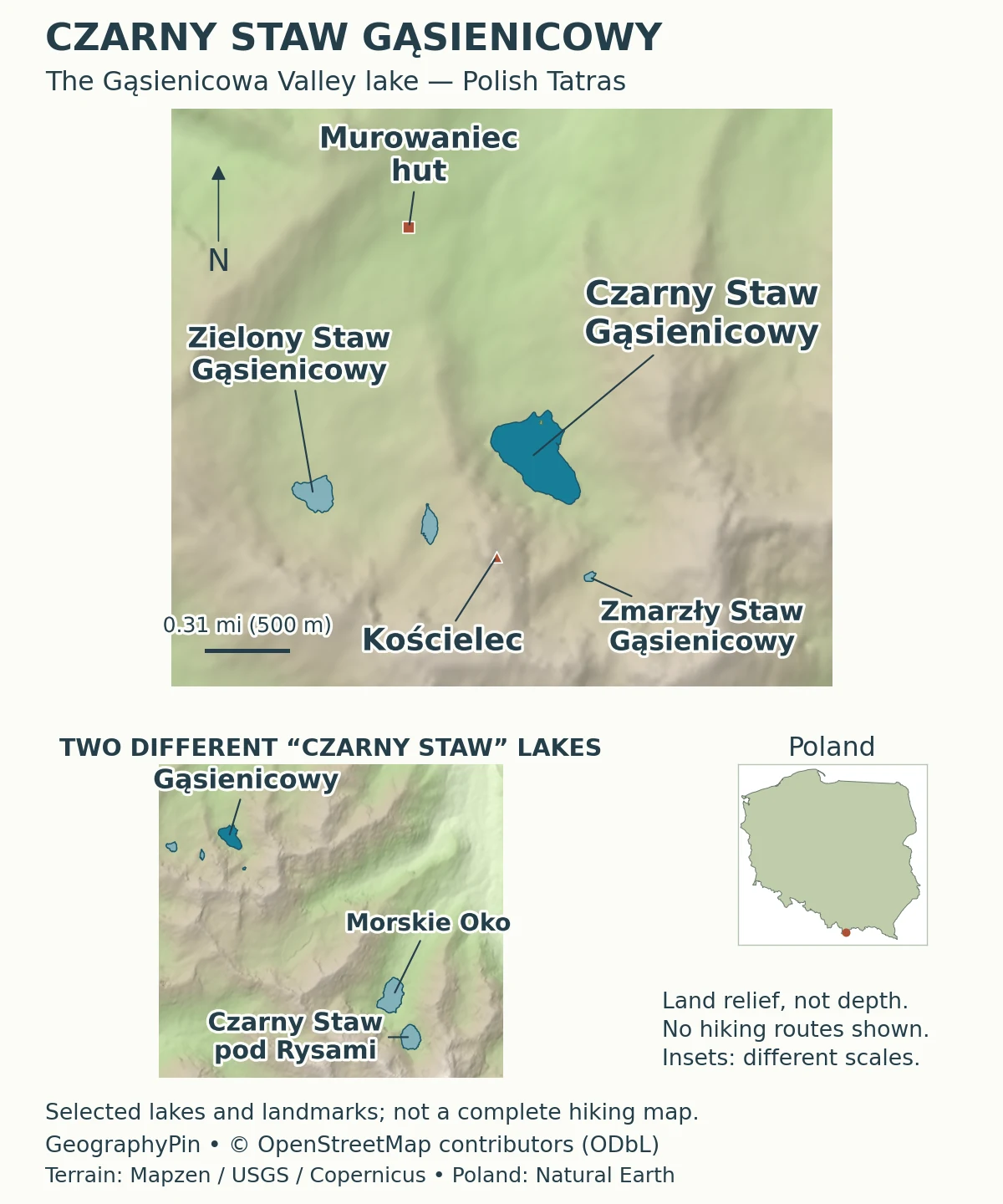
When checking a photograph, look for a reliable full caption or a mapped location. Dark water and steep mountain walls are not unique identifiers. The map helps establish the place through its actual outline and neighboring features instead of relying on color or a loosely translated title.
2. Lake Facts and the Elevation Question
The area and depth describe a relatively compact but deep mountain lake. Elevation is a different measurement: it describes a point above sea level, not the distance from the surface to the lake bed. Published visitor information does not always use the same kind of point.
| Fact | Reference | Source and meaning |
|---|---|---|
| Surface area | About 43.7 acres (17.7 hectares) | PTTK regional lake description |
| Maximum depth | About 167 feet (51 meters) | PTTK reference value, not the depth at every shore point |
| Lake sampling-site elevation | About 5,328 feet (1,624 meters) | Sobczyk and colleagues: May 2019 sampling, published 2020 |
| Water-body type | Natural glacial lake | A rock basin with a northern moraine barrier |
Why the elevation references differ
The research paper identifies its lake sampling site at about 5,328 feet (1,624 meters). Zakopane’s official summer-route page instead labels the highest route point at about 5,341 feet (1,628 meters). The PTTK attraction page displays about 5,348 feet (1,630 meters) beside its mapped location.
These sources do not provide a shared surveying method or vertical datum that would justify merging the numbers. A route high point is also not automatically a measurement of the water surface. The figures are retained with their stated purposes, rather than explained away as proven water-level change or averaged into an invented “correct” elevation.
3. A Glacial Rock Basin and a Moraine
Erosion and deposition both help explain the lake
PTTK describes a rock basin excavated by a glacier and closed on its northern side by a terminal moraine. Poland’s government educational platform also uses Czarny Staw Gąsienicowy as an example of a cirque lake: a lake occupying a mountain-glacier hollow.
These descriptions are complementary. Moving ice can erode and deepen a hollow, while rock fragments carried by that ice can accumulate near its front. After the ice retreats, water can occupy the depression behind a barrier. “Glacial lake” therefore describes a history involving more than simply melting ice filling a random low spot.
A cirque is a mountain hollow associated with glacier erosion. A moraine is accumulated debris. One describes the basin’s erosional setting; the other describes material deposited by the glacier. Our guide to glacial erosion landforms explains these contrasts at a broader scale.
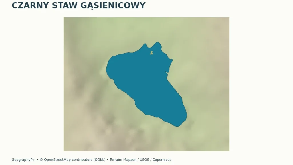
PTTK locates the small island near the outlet of Czarny Potok. This gives the lake a drainage connection as well as a distinctive feature on its outline. The map preserves that island, but surrounding terrain shading shows land relief, not the shape or depth of the submerged basin.
4. Similar Names, Different Tatra Lakes
Czarny Staw pod Rysami is not this lake
Czarny Staw pod Rysami lies above Morskie Oko in another part of the Tatras. Zakopane’s official route description approaches it from Morskie Oko, rather than from Hala Gąsienicowa and Murowaniec. The shared words Czarny Staw are a naming similarity, not evidence that the routes lead to the same destination.
The distinction also matters when reading lake statistics. A depth, elevation, photograph or approach description for the lake below Rysy must not be transferred to the Gąsienicowa lake simply because both are shortened to “Black Pond.” Keeping the qualifier attached is the easiest way to avoid that mistake.
Closer to this lake, Zielony Staw Gąsienicowy and Zmarzły Staw Gąsienicowy are also separate water bodies. They share the Gąsienicowy part of their names, not a single shoreline. The locator shows the nearby lake pattern; it does not treat a whole group of basins as one lake.
Hala Gąsienicowa is likewise an area name, while Murowaniec is a mountain hut. A route beginning at the hut and ending beside the lake is not a loop around an attraction called “Hala Lake.” Place names become much easier to follow once the lake, valley area and building are kept in separate categories.
5. The Hala Gąsienicowa Approach
The published distance begins at the hut area
Zakopane’s official summer-route page describes the Hala Gąsienicowa–Czarny Staw Gąsienicowy segment as about 1 mile (1.6 kilometers). The description begins after leaving the Murowaniec hut and follows the signed approach toward the lake. That distance is not the entire journey from central Zakopane or from every possible trailhead.
Treat the approach as one segment of a larger mountain plan. Before setting out, identify how you will reach the starting area, the onward and return distances, the available daylight and the current conditions. Reaching the lakeshore does not automatically make a continuation toward a high pass or summit appropriate.
The official summer description specifically warns about frozen snow on the approach in early spring. A route that looks straightforward in a summer photograph may be very different under snow or ice. Use the current Tatra National Park visitor bulletin and its linked avalanche information rather than treating this geographic locator as navigation or a safety assessment.
For the named summer approach, consult Zakopane’s official route description. The route’s starting point matters as much as its headline distance.
6. A Protected Lake, Not a Swimming Destination
Keep water and shoreline habitats undisturbed
Tatra National Park instructs visitors to stay on marked trails and not to swim, wash or rinse dishes in its lakes and streams. The lakeshore is a place to observe the water and landforms, not to turn the basin into a bathing spot. Carry out your rubbish and follow current park instructions.
The park’s water-ecology material also discusses past introductions of fish into naturally fishless Tatra lakes and identifies Czarny Staw Gąsienicowy among lakes affected by introduced brook trout. A natural-looking basin is not necessarily an ecosystem without a history of human influence.
Water clarity is not a drinking-water test. The park advises against drinking untreated water from mountain lakes, streams and springs. A research paper examining particular samples at a past date does not establish that water collected during your visit is safe to drink.
The most useful way to enjoy the setting is to read its layers together: the full name identifies the correct lake; the map distinguishes neighboring basins; the measurements describe its scale; and the glacial landforms explain why water occupies this mountain hollow. Protecting the shore helps preserve the very landscape the visit is meant to reveal.
What Did We Learn Today?
Czarny Staw Gąsienicowy occupies a glacier-shaped rock basin with a northern moraine barrier. Its name distinguishes it from the lake below Rysy and from other Gąsienicowa lakes. Elevation references need their source context, and the hut-to-lake approach is only one segment of a mountain visit.
Sources & Data Notes
US customary equivalents are rounded. A lake sampling site, a route high point and an attraction coordinate are not automatically interchangeable elevation references. No exact lake-formation date or measured recent water-level change is inferred from these sources.
- PTTK: Czarny Staw Gąsienicowy. Lake area, maximum depth, glacial rock basin, northern moraine and outlet/island context; mapped attraction header gives 1,630 meters.
- Sobczyk, Wójtowicz and Pawul (2020): Physical and Chemical Indicators of Surface Waters of the Tatra National Park. Journal of Ecological Engineering 21(5), 174–179. Lake sampling-site elevation on page 175; May 2019 sampling is not a new elevation survey or a present-day water-safety guarantee.
- Zakopane: Hala Gąsienicowa–Czarny Staw Gąsienicowy. Official summer approach; 1.6-kilometer segment and 1,628-meter highest route point.
- Zakopane: Morskie Oko–Czarny Staw pod Rysami. The separate lake and its Morskie Oko approach.
- Polish government educational platform: lake origins. Czarny Staw Gąsienicowy as a cirque-lake example.
- Tatra National Park: waters. Aquatic ecosystems and historical fish introductions; not a dated census of present fish numbers.
- Tatra National Park: current visitor bulletin. Marked-trail rules, water protection, current conditions and safety notices.
Map sources and method: Original GeographyPin cartography uses complete OpenStreetMap lake geometry, including the main lake’s island, the Murowaniec building footprint and the Kościelec summit position: © OpenStreetMap contributors, ODbL. Nearby lakes are separate mapped features, not guessed additions to one basin. Historical Mapzen elevation tiles show surrounding land relief, not bathymetry. Global terrain data courtesy of the U.S. Geological Survey; European terrain produced using Copernicus data and information funded by the European Union – EU-DEM layers. Exact per-tile source composition was not independently resolved; see Mapzen source attribution. The Poland locator uses Natural Earth public-domain data. The main map uses a latitude-adjusted geographic aspect and an approximate scale bar; insets have separate scales. No park boundary, glacier limit or hiking route is inferred.