Crater Lake Rim Drive is the 33-mile (53-km) road around the caldera in southern Oregon. Start with the section that reaches your chosen overlook. It may be possible to reach Rim Village when neither half of the scenic loop is open to cars.
Treat the open part of Crater Lake Rim Drive as an out-and-back, not as a loop. A closure on East Rim can leave overlooks reachable from one end but not the other. If both rim drives close, leave the loop out of your plans and check whether the road from Oregon 62 to Rim Village is open.
How to use this article: Try the road-section map, see East Rim viewpoints, or go to the dated access check.
Choose the entrance that serves your stop
The road-section map
From Oregon 138, North Entrance Road leads to North Junction, where West Rim Drive heads toward Rim Village and East Rim Drive heads toward Cleetwood Cove. From the south or west, Oregon 62 leads to Annie Spring Entrance and Munson Valley Road. That approach reaches Steel Visitor Center first, then continues uphill toward Rim Village.
If the North Entrance or Rim Drive is closed: Check the South Entrance approach from OR 62 before setting out. If the uphill segment is open, Rim Village gives you a view from the rim without driving the loop. Steel Visitor Center is below the rim and does not have that view.
| What you want | Road to check first | How to change the plan |
|---|---|---|
| One rim viewpoint, not a loop | OR 62 to Annie Spring and Munson Valley Road. | If the road to Rim Village is open, use the promenade. If the last uphill section is shut, Steel Visitor Center is below the rim and is not a substitute lake overlook. |
| Open west-rim drive from Rim Village | West Rim Drive toward Discovery Point and Watchman. | Stop only at viewpoints reached before the closure. An open west segment does not guarantee access through North Junction or a connection to East Rim Drive. |
| East Rim viewpoints or a full loop | Check the East Rim connection at North Junction and near Steel Visitor Center separately. | If a middle segment is closed, visit from the open end that reaches your stop and return the same way. Do not plan the full circuit until both rim drives and the connecting road are open. |
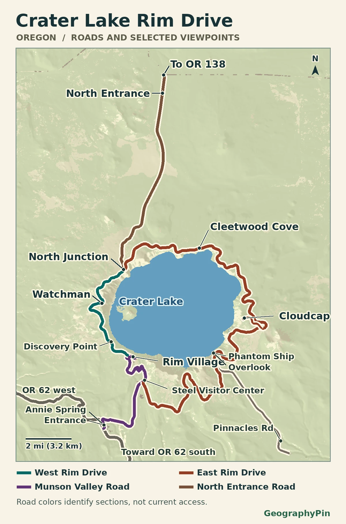
The entrances and the road around the lake are separate decisions. If the North Entrance is closed but the west or east end is reachable from Munson Valley, approach from Oregon 62 and recheck the specific road segment. Do not count the closed North Entrance Road as a way out at the end of the day.
What you can see at Rim Village
A lake view without driving around the rim
Rim Village is the best place to check first if you want a lake view without committing to the whole drive. The promenade follows the edge of the caldera near the parking areas and lodge. You can stop along it without taking a trail below the rim, although fog and snow can still block the view or cover the pavement.
Rim Village and Steel Visitor Center are not the same stop. The last 3 miles (4.8 km) of Munson Valley Road climb from park headquarters to Rim Village, and the park can close that stretch even if the lower road is open. The Rim Village promenade and the Sinnott Memorial Overlook also have different access: an open road does not mean that the memorial is open.
West Rim: Discovery Point and Watchman
Two pullouts, two different walking choices
When open, West Rim Drive runs about 6 miles (9.7 km) between Rim Village and North Junction. Discovery Point is about 1 mile (1.6 km) by road from Rim Village. The separate Discovery Point Trail is about 2 miles (3.2 km) round trip from Rim Village, according to the park’s hiking guide. Do not use the road mileage as the walking distance.
Watchman Overlook is about 3.8 road miles (6.1 km) from Rim Village. The roadside overlook offers a west-rim view of Wizard Island. The distinct Watchman Peak Trail is a 1.6-mile (2.6-km) round trip to the lookout; it is not required to see the lake from the roadside stop.
East Rim: Cloudcap and Phantom Ship
Check the spur as well as the main road
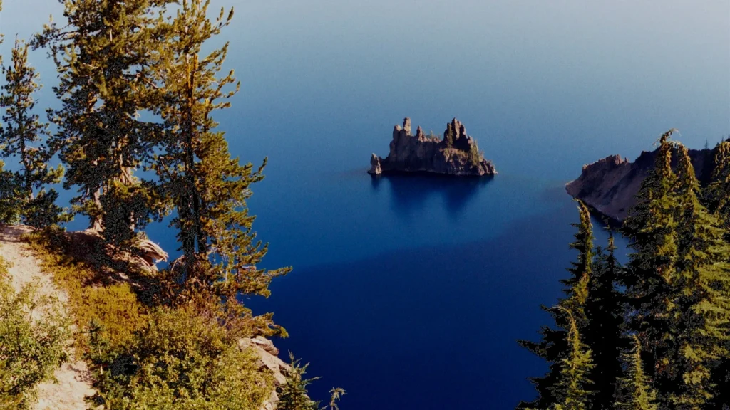
Cloudcap Overlook is reached by a paved spur near the Mount Scott Trailhead, not from the west rim. Phantom Ship Overlook is farther along the southeast section near Kerr Notch, by the turn for Pinnacles Road. The small island is also visible from Sun Notch, which has a separate short walk from East Rim Drive. Check whether the roads to those two stops are actually connected on your visit rather than assuming one always replaces the other.
Cleetwood Cove is a different decision. Its trailhead is 4.6 road miles (7.4 km) from North Junction, but the National Park Service has closed the trail and its parking lot for rehabilitation. The project removes the only legal public route to the lake shore and suspends public boat tours for the 2026, 2027 and 2028 summers. An open East Rim road would not reopen either the trail or the boat tours.
Snow, construction and the latest road check
What the park listed on November 21, 2026
The National Park Service conditions bulletin, updated November 19 and checked November 21, listed North Entrance Road, West Rim Drive, East Rim Drive, Cloudcap and Pinnacles Road closed to vehicles for the season. It listed Oregon 62 through the park and Munson Valley Road to Rim Village open, including the final climb. That left Rim Village as the road-accessible choice for the lake view, weather permitting, not a starting point for the loop.
The usual seasonal closure target for the rim roads is November 1, or sooner after significant snowfall. Snow removal can reopen pieces at different times; East Rim construction can also affect individual segments independently of snow. Recheck the road-status table in the park’s current conditions before you set out, then the park’s alerts for your intended stop. This dated check is not a prediction for a later visit.
For a winter drive, check the park’s snow-zone instructions and Oregon’s traction guidance too. An open approach to Rim Village does not mean you can drive it without the winter equipment called for by signs.
Frequently Asked Questions
Which overlooks stay connected when only part of Rim Drive opens?
Look at the named endpoints. If the West Rim portion between Rim Village and Watchman is open, the route passes the Discovery Point area. An East Rim opening near Steel does not by itself mean you can reach Cloudcap or Cleetwood from that end. Use the current closure limits and any separate spur alerts.
What changes if the North Entrance closes?
Approach on Oregon 62 from the west or south and check Munson Valley Road before driving uphill. Do not plan to enter or exit via Oregon 138 on the closed entrance road.
Can I reach the water if I can drive to the rim?
No during the Cleetwood construction closure. The only legal public trail to the shore and its parking lot are closed, and there are no public boat tours in the 2026–2028 summer seasons. A rim overlook remains a view from above.
What Did We Learn Today?
Rim Village can be worth the trip even when the scenic loop is closed. For other viewpoints, match your stop to the open road section and plan your way back before setting out. Cleetwood Cove is a separate construction closure, so access to the rim does not mean access to the shore.
Sources & Data Notes
Road-status check: November 21, 2026, against the NPS bulletin updated November 19. The map uses public NPS road centerlines, USGS terrain and 2021 satellite water mapping; it depicts physical roads, not a dated status or a walking route. © ESA WorldCover project 2021 / Contains modified Copernicus Sentinel data (2021) processed by ESA WorldCover consortium.
- National Park Service: current road and facility conditions
- National Park Service: Rim Drive length, vista stops and two-way layout
- National Park Service: by-section overlooks and North Junction orientation
- National Park Service: Discovery Point, Watchman and Sun Notch walking approaches
- National Park Service: Cleetwood trailhead location and rehabilitation-season closures
- National Park Service: project notice, trail and parking closure, and boat-tour suspension
- National Park Service: 2026 road and overlook rehabilitation
- NPS Public Roads, Crater Lake National Park linework
- USGS field guide: coordinates and road junctions around the park
- Mapzen elevation tiles: U.S. source acknowledgments
- ESA WorldCover 2021 water (CC BY 4.0)
- Featured image: Phantom Ship from Sun Notch, Glenn Scofield Williams; cropped and resized
- Featured photograph license: CC BY 2.0