Coniston Water looks like a narrow blue corridor between the fells, but its geography is more than a scenic outline. Reading the basin, its feeder streams and its southern outlet helps explain both the lake itself and the settlement and mountain that share its name.
Coniston Water is a long freshwater lake in England’s southern Lake District. It occupies a glacial valley beside Coniston village, below the Coniston fells. Streams feed the lake from surrounding slopes, and the River Crake drains its southern end toward the Leven estuary and Morecambe Bay.
How to use this article: Distinguish the lake, village and mountain, interpret the depth figures, or follow the lake’s drainage system.
1. Where Is Coniston Water?
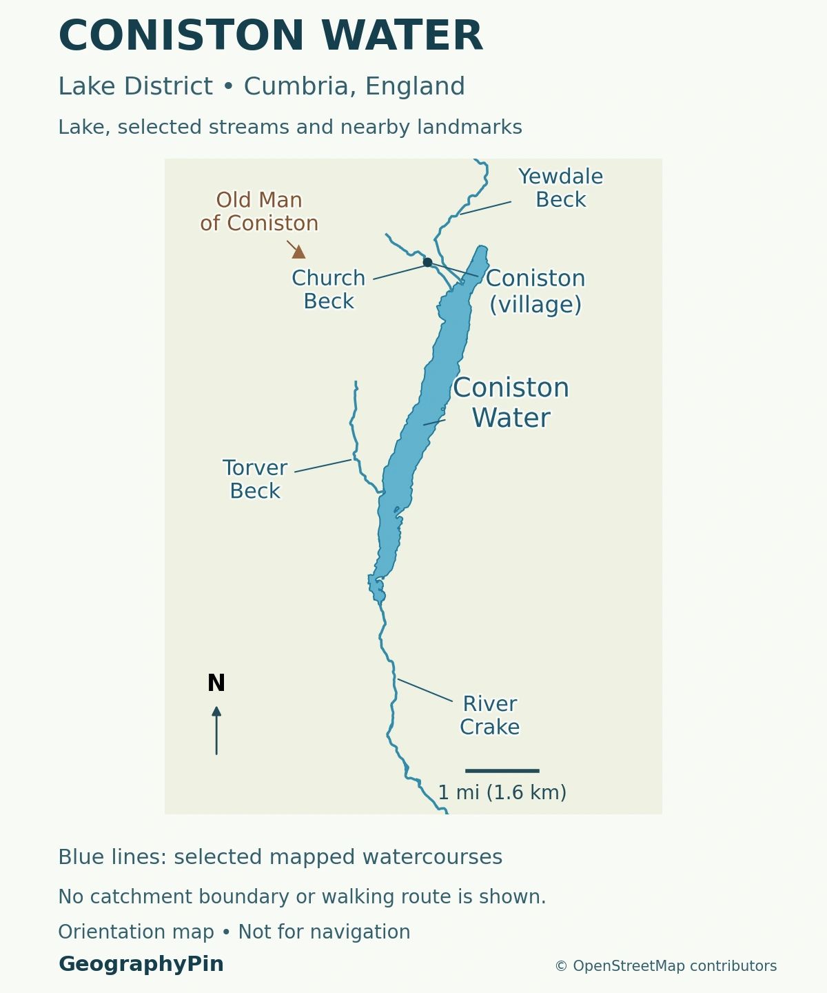
Coniston Water lies in the southern Lake District National Park, in Cumbria, England. Its long basin runs broadly north to south, with Coniston village near the northern end and the Old Man of Coniston rising to the northwest. The water, the village and the mountain are three different geographic features.
One name connects a lake, a village and a fell
Coniston Water is the lake. Coniston usually identifies the village when used as a settlement name. The Old Man of Coniston, also called Coniston Old Man, is the mountain, not an island or another name for the lake itself.
This distinction is useful when reading directions. A village address, a lakeshore landing and a mountain walking route do not lead to the same place. The park authority describes the lake as roughly half a mile from the village, while the fell rises beyond the settlement.
The wider Lake District landscape contains many separate lake basins. Nearby Windermere and Esthwaite Water should not be read as arms of Coniston Water. Each name identifies a different waterbody, even when several appear together in a view from the fells.
2. Length, Area and Depth: What the Figures Mean
The table uses one reference series: Table 1 of UKCEH’s Lakes Tour 2021 report, published in 2023. These are reported lake characteristics, not measurements made for this article.
| Measurement | Reported value, converted and rounded |
|---|---|
| Length | About 5.4 miles (8.7 kilometers) |
| Maximum width | About 0.45 mile (0.73 kilometer) |
| Surface area | About 1.9 square miles (4.9 square kilometers) |
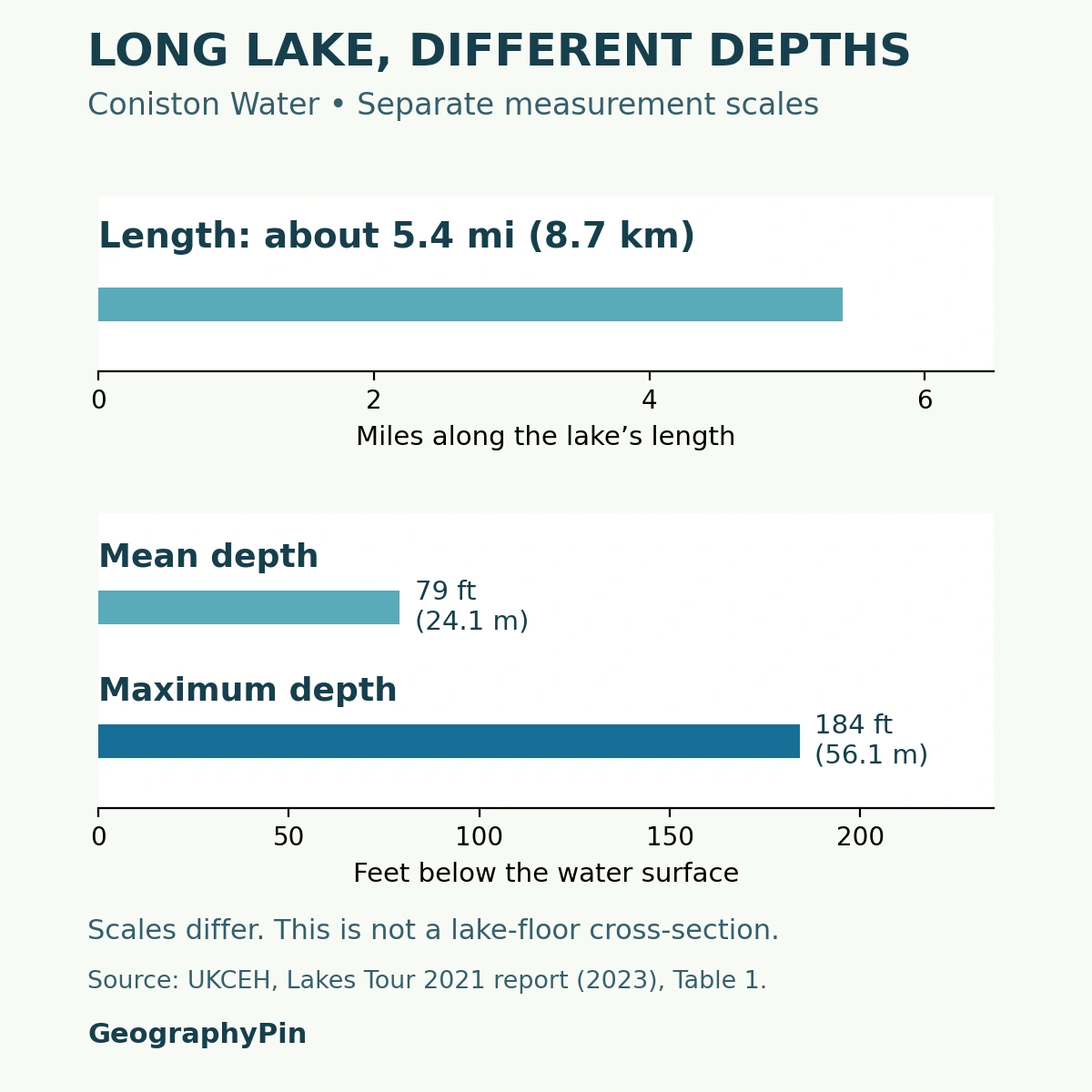
| Mean depth | About 79 feet (24.1 meters) |
| Maximum depth | About 184 feet (56.1 meters) |
| Lake altitude | About 144 feet (44 meters) above sea level |
Maximum depth is not the depth everywhere
Length measures the lake horizontally; depth measures downward from the surface. Mean depth summarizes the basin as a whole, while maximum depth describes its deepest point. Neither tells you the depth beside a particular jetty or beach.
The comparison graphic keeps these different measurements separate. It is not a survey of the lake floor and should not be used to infer a safe route for a boat or a uniform slope beneath the water.
Published reference values differ. UKCEH’s separate UK Lakes Portal gives 471 hectares, equivalent to about 1.82 square miles (4.71 square kilometers), and an elevation of about 151 feet (46 meters). Those differences alone do not establish that the lake has shrunk or risen. The table retains the report’s figures rather than combining different reference sets into a false precision.
3. How Glaciation Shaped the Long Basin
The national park authority identifies Coniston Water as a linear glacial lake. Its elongated form follows a valley shaped by ice rather than a circular volcanic crater. The lake is one part of a much larger glaciated landscape, including the surrounding slopes and higher valleys.
Moving ice reshaped an older drainage landscape
The British Geological Survey describes repeated glaciation widening, straightening and deepening pre-existing Lake District river valleys. The landscape was not carved from a flat surface in one simple event. Later ice also removed much of the evidence of earlier episodes, so the surviving landforms do not provide a complete record of every stage.
Two processes help explain the erosive work. Rock fragments carried at a glacier’s base grind against the ground, a process called abrasion. Moving ice can also remove blocks of rock, known as plucking. Over time, erosion and the transport of debris can transform a river valley into a broader glacial trough.
Coniston’s present water occupies part of that inherited valley. Calling it glacial describes the basin’s history, not a claim that a glacier feeds it today. Streams, rainfall and the outlet now connect the lake to the ordinary water cycle.
Nor did landscape change stop when the ice disappeared. BGS describes later slope movement, river sediment and alluvial deposits modifying Lake District valleys. The broad glacial form remains, but the shoreline and valley floor are not an untouched snapshot of the ice age.
4. Where the Water Comes From and Where It Goes
Church Beck and Yewdale Beck bring water into the northern part of Coniston Water around Coniston, while Torver Beck enters the western shore farther south. These are examples of the smaller streams, locally called becks, linking the surrounding land to the lake.
At the southern end, water leaves through the River Crake. The Crake carries it toward the Leven estuary at Greenodd and Morecambe Bay. Coniston Water is therefore an open-drainage freshwater lake, not a closed basin without a surface outlet.
The lake catchment is not the whole Coniston–Crake catchment
A catchment is the land area draining toward a chosen outlet. UKCEH’s reference table gives roughly 24 square miles (62.5 square kilometers) for Coniston Water’s catchment. South Cumbria Rivers Trust describes a larger combined Coniston Water and River Crake catchment of about 36 square miles (92 square kilometers).
These figures answer different questions. A boundary drawn for the lake outlet does not include every additional area draining into the river downstream. That is why a catchment number needs its outlet or geographic scope attached.
The connection is not only about water volume. Runoff and streams can carry sediment and other material from the surrounding land. Our explanation of how a lake works separates the basin that holds water from the catchment that supplies it. Coniston provides a concrete example of those connected parts.
5. A Working Landscape Before a Scenic Destination
Coniston village developed through farming and its connection with copper mining and slate quarrying. The parish council describes the later growth of Victorian tourism, supported in part by the railway. The lake’s setting is therefore a cultural landscape as well as a glacial one.
The history of the Steam Yacht Gondola illustrates that change. The National Trust explains how a Furness Railway director saw an opportunity to connect a pleasure cruise with the Coniston railway line. Water, rail and road journeys became parts of a combined visitor experience rather than separate ways of seeing the district.
On the eastern shore, Brantwood was John Ruskin’s home. His connection with Coniston belongs to the lake’s artistic and conservation history; it is different from the mining history of the fells or the physical processes that formed the basin.
The lake is also associated with Donald Campbell and Bluebird. The Ruskin Museum records that Campbell died during a water-speed-record attempt on January 4, 1967. It was a fatal attempt, not a successfully completed record on that date. This history is important, but it should not overshadow the lake’s longer story of settlement, land use and changing transport.
6. Reading Shore Access and Water Conditions Carefully
A lake outline on a map shows water, not permission to cross every piece of land beside it. Use the national park’s current lake guide for facilities, access points and activity information. Do not infer an uninterrupted public lakeshore path from the shape of the shoreline.
The park’s activities guidance lists swimming, paddling, rowing, sailing and powered craft on Coniston Water, subject to the relevant rules. Permission for an activity is not a statement that conditions are safe for every person on every day. A quiet-looking surface does not reveal underwater hazards or water temperature.
Different checks answer different questions
For an outing, distinguish weather and water conditions, access arrangements, and water-quality information. They are separate checks. A historical ecological survey does not establish today’s swimming conditions, and a bathing-water result for a named site is not a measurement of every part of the lake.
Consult the national park’s lake activities guide, local notices and the Environment Agency’s bathing-water information. Choose the named site you intend to use rather than assuming one result covers the whole shoreline. For public transport or boats, check the operator’s current service information instead of relying on an old timetable.
Geographic understanding makes those practical checks easier: identify the village, the shore you need, the direction of drainage and the difference between a lake measurement and a site-specific condition.
What Did We Learn Today?
Coniston Water is the lake, Coniston is the village and the Old Man of Coniston is the mountain. Glaciation reshaped the valley, while streams and the River Crake connect the present lake to Morecambe Bay. Length, depth and catchment area describe different things, and published reference values need their sources. The landscape also records farming, mining, tourism and cultural history.
Sources & Data Notes
The dimensions table retains the reference characteristics in UKCEH’s 2023 report. Its seasonal water-quality fieldwork occurred in 2021–22; the table is not presented as a new bathymetric survey. Unit conversions are rounded. The separate UK Lakes Portal reports different area and elevation values, noted above without attributing the differences to an unverified cause. Lake and combined lake–river catchments are distinguished. No current water-quality rating is claimed.
- UKCEH: Lakes Tour 2021, published 2023, Table 1 (p. 11)
- UK Lakes Portal: Coniston Water, waterbody 29321
- Lake District National Park: Coniston and the southern lakes
- British Geological Survey: Ambleside district, Quaternary and glacial history
- Royal Geographical Society: glacial erosion and inherited landscapes
- South Cumbria Rivers Trust: Coniston and Crake catchment
- Coniston Parish Council: village history
- National Trust: Gondola and the history of tourism
- Ruskin Museum: Donald Campbell’s Coniston history
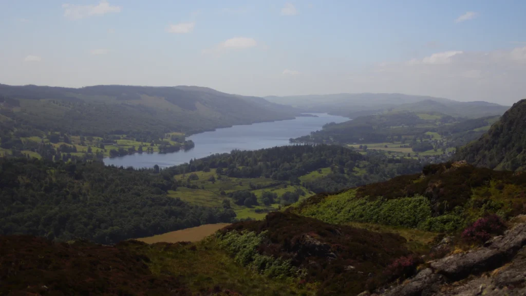
Featured photograph: “Coniston Water seen from Holme Fell” by Jacob Moreton (JacobHM), CC BY-SA 4.0. Cropped, resized and converted to WebP; the adapted photograph remains under that license. This is a real view from Holme Fell, not from the Old Man of Coniston.
Map methods: The locator uses OpenStreetMap’s lake polygon with its mapped islands, settlement and peak points, and selected stream and river geometries. The lower reach of Torver Beck is shown at its actual mapped lake entry. British National Grid projection and equal axis scaling preserve geographic relationships; the scale label rounds the metric equivalent. No catchment boundary, navigational route, ownership boundary or lake-floor contours are inferred.
Measurement graphic: Separate length and depth axes compare published quantities without reconstructing the basin’s shape. Bar lengths use unrounded unit conversions; displayed values are rounded. Mean and maximum depth are not assigned to particular map locations.