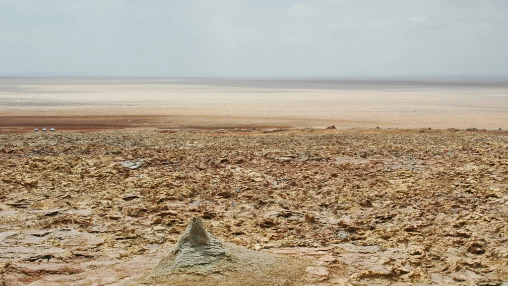
At the Dallol salt pan, the ground lies hundreds of feet below sea level, even though it is on land. A west-to-east slice through the Danakil Depression shows why: the floor is bracketed by higher terrain, not open to the nearby Red Sea.
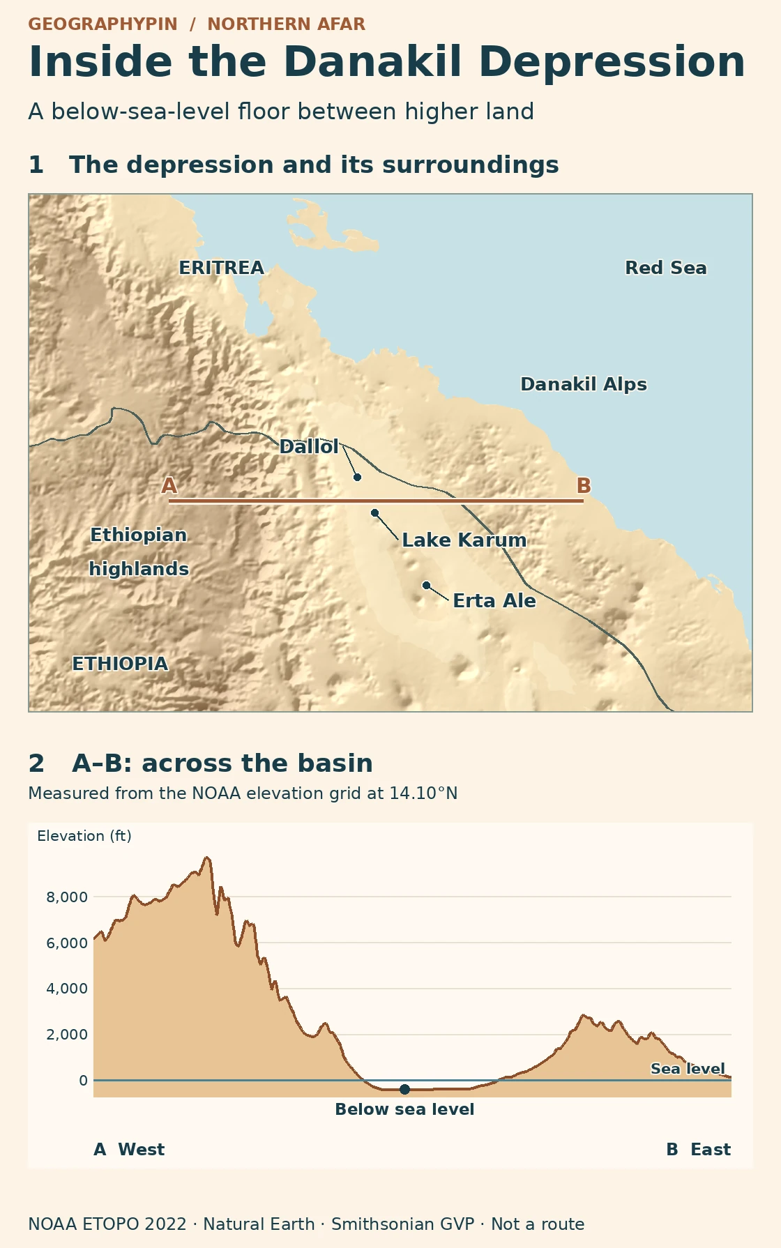
The Danakil Depression is a rift basin in northern Afar, between the Ethiopian highlands and the Danakil Alps near the Red Sea. The Dallol salt pan is about 380 feet (116 m) below sea level. That describes the land’s elevation, not the depth of water: higher ground separates the basin floor from the sea.
How to use this article: Follow the A–B line across the basin, then compare the salt pan with its surrounding volcanic features and the depression with Afar as a whole.
Where the Danakil Depression lies
The elevation line across northern Afar
The depression occupies northern Afar. The steep Ethiopian highlands stand west of it; the lower but still prominent Danakil Alps, part of the raised Danakil Block, stand east of it. Where the floor broadens around the Dallol salt pan and neighboring Lake Karum, the contrast is especially easy to see. The broader Ethiopia geography profile locates Afar relative to the rest of the country.
The map’s A–B line follows latitude 14.10°N from the western highlands across the basin to higher land on the Red Sea side. The profile shows the land surface along that line, with sea level held constant as a reference. It does not pass through every named feature on the map, and the vertical scale is exaggerated so that the low floor is visible.
Why below sea level does not mean underwater
A depression can reach below sea level without flooding if there is no open surface connection to the ocean. Higher ground on the profile separates the salt floor from the coast. The profile crosses the basin east–west; it does not show every possible connection. Field researchers also document higher barriers north of the Danakil lowland, between the basin and the Gulf of Zula.
The region was not always isolated from the sea. Researchers studying reef remnants, sediments and boreholes found evidence of a former marine basin followed by isolation and evaporation. As water evaporated, dissolved minerals accumulated in deposits called evaporites. The thick salt beneath the floor is evidence of that longer history. It does not mean the modern salt pan is still part of the sea.
Salt flats and volcanoes along the basin
How to compare the salt and volcanic features
At the northern end of the mapped lowland, Lake Karum (also called Lake Assale) lies beside the Dallol salt pan. The pan elevation reported in the borehole study is about 380 feet (116 m) below sea level. The Smithsonian’s Global Volcanism Program lists about 157 feet (48 m) below sea level for Dallol itself. Both can be correct: one is a value for the pan, the other is for a volcanic feature above the nearby floor.
Farther south, the Erta Ale Range marks a volcanic segment along the rift. The salt floor and volcanic ridges belong to the same extended basin, but they record different processes. The floor preserves salts laid down and reworked by water and evaporation. The range marks places where magma reached the surface. A map of volcanic segments will therefore not outline the same land as a map of low elevation.
The Danakil Depression is not all of Afar
An individual basin within a wider tectonic junction
The Afar triple junction describes the broader tectonic setting in which the Red Sea rift, the Gulf of Aden rift and the Main Ethiopian Rift meet. The Danakil Depression is a basin in the northern part of that setting, not the full land area of the triple junction. The Danakil Alps are an adjacent raised block, not part of the salt floor, even though they share its regional name.
Geologists may draw an edge at a fault or where basin sediments give way to older rock. A terrain map instead makes the contrast between the low floor and the surrounding rises visible. Ethiopia’s Afar administrative region has its own boundary, which does not follow any one of those geological or height criteria. The map here locates landforms rather than drawing an exact perimeter around the depression.
Frequently Asked Questions
Is the whole Danakil Depression below sea level?
No. Parts of the floor, including the Dallol salt pan, are below sea level. The profile shows higher terrain immediately on both sides, and volcanic hills can rise above the neighboring salt flats.
Does the A–B line go through the Dallol crater?
No. It follows 14.10°N, south of the Smithsonian’s Dallol reference point. The crater and the salt pan are separate reference features, so their published elevations do not have to match the lowest modeled grid cell on the line.
Are Lake Karum and Lake Assale different lakes?
No. They are names for the same lake beside the Dallol salt pan. The published field literature also uses spellings such as Lake Assele.
What Did We Learn Today?
At Danakil, the low elevation tells you how far the basin floor sits below a reference level. The salt tells you about water and evaporation over time. The surrounding terrain explains why the floor can be lower than the nearby Red Sea without lying underwater.
Sources & Data Notes
View sources and map notes
- Bastow and colleagues, Danakil seismic reflection and borehole evidence, 2018, especially the field context and sedimentary evidence for former marine conditions. The rounded salt-pan elevation refers to the location described by this study, not a regional minimum.
- Field observations of northern Afar and the Danakil Block and field mapping of the Dallol geothermal area, including the northern barriers and Lake Assale/Karum name variants. Dallol’s modern salt surfaces are described in a geological field study published in Frontiers in Earth Science.
- Smithsonian Global Volcanism Program: Dallol and Erta Ale, for locations and feature elevations. The map is not an activity report or access map.
- Original GeographyPin map and profile use the NOAA NCEI ETOPO 2022 global elevation model, sampled on 14.10°N, 39.30°E–41.50°E, with a 45-arc-second working grid. Values are interpolated from a grid, not surveyed spot heights. Natural Earth provides generalized coastline and land boundaries.
- Featured photograph: Rolf Cosar, salt plain viewed from Dallol, CC BY 3.0, cropped.
