Ethiopia is close to the equator, but much of its best-known landscape is high above sea level. Elevated plateaus and mountain slopes contrast with the hot lowlands of Afar, while river gorges and the Rift Valley interrupt any impression of one continuous flat highland. This vertical geography helps explain the country’s climates, cities and farming landscapes.
Ethiopia is a landlocked country in the Horn of Africa, with Addis Ababa as its capital. Its main geographic contrast is between the Ethiopian Highlands, the Rift Valley and surrounding lowlands, including Afar. Higher elevations generally have cooler conditions than the lowlands, so tropical latitude does not mean uniformly hot weather.
How to use this article: Compare the major landscape settings, explore why the highlands are cooler, or follow the Blue Nile and Awash.
1. Locate Ethiopia in the Horn of Africa
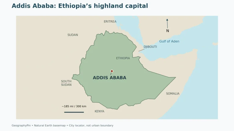
Ethiopia lies in northeastern Africa, within the Horn of Africa and the wider East African region. It borders Eritrea, Djibouti, Somalia, Kenya, South Sudan and Sudan. It has no coastline, despite its proximity to the Red Sea and Gulf of Aden.
Addis Ababa is an inland highland capital, not a coastal gateway. The country’s international trade therefore depends partly on transport connections through neighboring countries. A route to a foreign port provides commercial access to the sea; it does not give Ethiopia a national coastline.
The national outline encloses much more than the central plateau. Western and northern uplands, southeastern highlands, the northeast’s Afar lowlands and the eastern and southern drylands occupy different settings. Mountains and escarpments can separate places that appear fairly close together on a small map.
Regional landscape names and political boundaries are different kinds of information. “Ethiopian Highlands” describes an extensive physical landscape, while Afar can refer to a wider geographic depression or to an Ethiopian regional state. Their meanings depend on context, and neither should be treated as a precise substitute for the other.
2. Country facts and Addis Ababa
| Item | Detail |
|---|---|
| Capital | Addis Ababa |
| Population | About 113.8 million projected for 2026 in the Ministry of Health’s 2024–2030 human-resources plan; not a new census count. |
| Published surface area | About 426,373 sq mi (1,104,300 km²), UN country-profile figure with a 2023 reference year. |
| Government | Federal parliamentary republic; president as head of state and prime minister heading the executive. |
| Federal working languages | Amharic is specified in the Constitution; subsequent policy added Afar, Oromo, Somali and Tigrinya. |
| Currency | Ethiopian birr |
| Administrative structure | 12 regional states and two city administrations, Addis Ababa and Dire Dawa. |
Population is a rounded national projection reproduced in a government planning document, not a 2026 enumeration. Other demographic series give substantially different estimates. Area is the UN-published surface-area figure, not a claim about dry land alone or a newly surveyed 2026 boundary. Square miles are rounded.
The reference year and method matter when reading Ethiopia’s population figures. A projection is not a new census, and estimates produced by different institutions can differ because their starting populations and demographic assumptions differ. The figure used here follows the identified source rather than combining incompatible series.
The Constitution names Addis Ababa as the federal capital. Its city-administration boundary is not automatically the same as every definition of the wider built-up or metropolitan area. The Addis Ababa geography profile explores the capital’s elevated setting in greater detail.
3. Highlands, Rift Valley and Afar
A high country cut by valleys and bordered by lowlands
| Setting | Landscape | Geographic significance |
|---|---|---|
| Ethiopian Highlands | Elevated plateaus and mountain country, dissected by deep valleys and gorges. | Altitude moderates temperatures; steep relief affects farming, settlement and transport. |
| Main Ethiopian Rift | A belt of lower terrain, escarpments, volcanic landscapes and lakes between highland blocks. | Connects with the wider East African rift system and separates contrasting upland settings. |
| Afar depression | Low-lying northeastern country associated with the meeting of major rift systems. | Strong contrast with the cooler highlands; active tectonics and arid environments are important. |
| Eastern and southern lowlands | Extensive lower, often dry country beyond the principal highland massifs. | Rainfall seasonality and water access shape livelihoods differently from wetter uplands. |
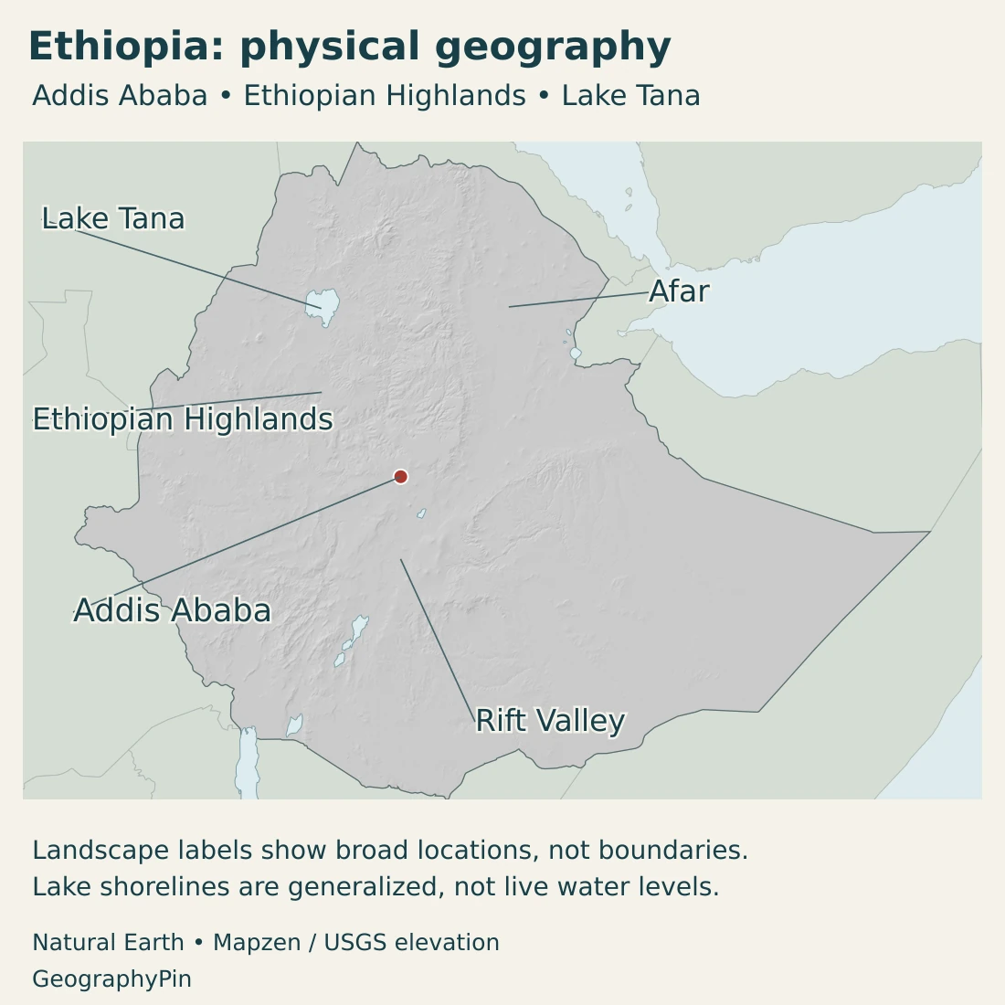
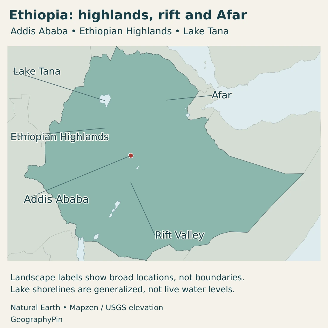
The highlands are not one level tabletop. Rivers have cut into them, creating valleys that can be much lower and warmer than neighboring plateau surfaces. Escarpments mark abrupt changes in relief, while some routes must negotiate both an ascent and a descent rather than simply cover horizontal distance.
The Main Ethiopian Rift divides major highland blocks and extends toward Afar in the northeast. Faulting, volcanic activity and crustal extension are central to its development. The broader rift system changes character along its length; it is not a uniform trench with identical conditions everywhere.
Afar lies where the Red Sea, Gulf of Aden and East African rift systems meet. This is why it is called a triple-junction setting. The explanation concerns tectonic structure, not a prediction that a new ocean will appear within a human lifetime or that every locality faces the same immediate hazard.
Volcanic rocks also form an important part of the elevated Ethiopian landscape. Ancient extensive eruptions and later rifting helped shape the country over geological time. Present-day valleys, mountains and plateaus reflect several processes working together, including erosion, rather than one recent tectonic event.
4. Climate and contrasting river basins
Why latitude alone does not explain the weather
Temperature generally decreases with elevation. As a result, a highland location can be much cooler than a lowland place at a similar latitude. Addis Ababa’s elevated setting makes it a useful example: its climate cannot be inferred simply from Ethiopia’s position in tropical Africa.
Relief also changes the movement of moist air and the distribution of rainfall. Wetter southwestern landscapes differ from the dry northeastern and southeastern lowlands. A national average conceals these contrasts and cannot describe the conditions on a particular mountain slope or lowland plain.
Ethiopia’s meteorological seasons are commonly described as Belg, Kiremt and Bega. Belg runs from February to May and brings rain to many areas, but its importance differs regionally. Kiremt, June–September, is the main rainy period for much of the country, while southern and southeastern lowlands often have a different seasonal pattern.
Bega, October–January, is commonly dry in much of the highlands, with cool nights and early mornings. It can nevertheless bring rain to parts of the south, southeast and southwest. These seasonal names are useful, but they do not mean that every Ethiopian region has the same rainy months.
Short-term weather and long-term climate should also be kept separate. A season’s drought or flooding does not erase the broader highland–lowland contrast, and a general description of the rainy season is not a current forecast. Local elevation, exposure and the year’s weather all matter.
The Blue Nile flows outward; the Awash ends inland
Lake Tana lies in the northwestern highlands and is the source lake of the Abbay, or Blue Nile. The river flows onward to Sudan, where it joins the White Nile at Khartoum. The connection makes the Ethiopian highlands part of a much wider international river system.
The lake and its surrounding wetlands support fishing, farming and habitats around the Bahir Dar area. The lake’s water surface, its catchment and the designated biosphere reserve have different boundaries. A reserve-area figure should not be presented as the size of the lake itself.
The Awash follows a contrasting route. It rises in the central highlands and flows through the rift toward the Afar lowlands, ending in the Lake Abbe system near the Djibouti border. This is internal drainage rather than a river flowing onward to the Red Sea.
Other Ethiopian basins follow still different routes, so the Blue Nile is not the outlet for all Ethiopian water. The contrast between the Abbay and Awash is especially useful: highland rainfall can feed an international river extending far beyond Ethiopia, or a basin whose water remains inland.
Water availability depends on when and where rain falls, how catchments store and release it, and how it is used. Rivers connect highlands and lowlands, but their flow and environmental pressures are not identical. Generalized map lines show orientation rather than current discharge or a complete drainage network.
5. Cities, regions and languages
Addis Ababa is both the federal capital and a major institutional center. It hosts the African Union and the United Nations Economic Commission for Africa, giving its highland location significance beyond national administration.
Bahir Dar has a different geographic setting beside Lake Tana. Dire Dawa lies on the eastern transport corridor associated with connections toward Djibouti. Jimma is linked with southwestern highland and coffee-growing country. These examples show how cities relate to lakes, routes and productive landscapes rather than occupying equivalent positions.
Regional states and city administrations are political units, not a simple map of altitude or climate. A regional boundary can cross uplands and lowlands, and a physical feature can extend across several jurisdictions. Administrative reorganization also means older lists of regions may no longer describe the current structure.
Constitutional language recognition and working languages
Article 5 of the Constitution recognizes all Ethiopian languages equally and names Amharic as the federal government’s working language. It also allows member states to determine their own working languages. Later federal policy added Afar, Oromo, Somali and Tigrinya alongside Amharic; that policy development should be distinguished from the Constitution’s original wording.
A working-language policy describes institutional use, not the full range of languages spoken by residents. It also does not make a whole physical region linguistically uniform. Ethiopia’s cultural geography and its administrative geography overlap, but neither can be reduced to the other.
6. Government, coffee and trade connections
Ethiopia has a federal parliamentary framework. The president is head of state, while executive leadership rests with the prime minister and Council of Ministers. The federal legislature includes the House of Peoples’ Representatives and the House of Federation. Regional governments operate within the federal structure; a list of regions is not a map of current security conditions or political control.
Coffee offers a concrete link between environment and production. Southwestern areas such as Jimma-Limu and Kaffa, and southern coffee landscapes including the Sidamo and Yirgacheffe areas, have different local conditions and production traditions. They are not interchangeable with the arid Afar lowlands.
Research on Ethiopian coffee farming connects suitability with temperature, moisture and elevation. The landscape includes different farming systems and climatic settings, rather than one uniform belt. A change in rainfall or heat can therefore affect growing areas differently, and a national production label does not explain the local environment.
Landlocked geography creates another economic connection. The Djibouti–Addis corridor links Ethiopia with a neighboring country’s maritime gateway. Its usefulness depends not only on distance but also on border crossings, road and logistics performance, and the reliability of the connection.
Current corridor investment addresses infrastructure and road safety along this regional link. The geographic lesson is broader than any single project: a coastal port, inland capital and communities along the route form a connected economic system even though they are separated by an international border.
Ethiopia’s highlands, lowlands and rift landscapes therefore affect much more than scenery. They influence growing conditions, the course of rivers, the location of cities and the effort needed to move goods. The strongest explanation combines relief, water and connections rather than treating tropical latitude as the whole story.
Frequently Asked Questions
Why are Ethiopia’s highlands cooler than its latitude suggests?
Their elevation lowers temperatures relative to nearby lowlands. Ethiopia’s tropical position influences climate, but altitude, relief and rainfall patterns create major local differences.
Does Ethiopia have a coastline?
No. Ethiopia is landlocked. It uses transport links through neighboring countries, including the Djibouti–Addis corridor, to reach maritime trade routes.
Does every Ethiopian river flow into the Nile?
No. The Abbay, or Blue Nile, connects Lake Tana with the wider Nile system, but the Awash drains inland toward Lake Abbe. Ethiopia contains several distinct river basins.
What Did We Learn Today?
Ethiopia’s high elevation explains why much of its climate differs from the hot conditions often associated with tropical lowlands. The Highlands, Main Ethiopian Rift and Afar form contrasting settings, while rivers follow different routes: the Blue Nile leaves the country, but the Awash ends inland. Addis Ababa’s highland position, coffee landscapes and connections to Djibouti show how geography shapes settlement and trade.
Sources & Data Notes
Country facts were checked in November 2026. Population estimates differ substantially between national and international series; this profile identifies its source and does not combine them into one count or density.
- Ministry of Health, human-resources plan 2024–2030: Country context, printed pages 2–3: regional structure and rounded 2026 demographic projection. The document notes differences between population sources.
- UN Data, Ethiopia profile: Surface area with a 2023 reference-year footnote. Population in this article follows the separately identified national projection, not the UN profile’s different series.
- Constitution of Ethiopia, WIPO Lex: Articles 5 and 49: language recognition, federal working-language wording and Addis Ababa as capital.
- Embassy of Ethiopia, Brussels, country profile: Federal institutions, working languages, currency and capital functions.
- PCGN, Ethiopia factfile 2026: Current naming and the February 2020 expansion of federal working languages.
- Ethiopian Meteorological Institute, Annual Climate Bulletin 2024: Introduction: seasonal definitions and regional differences. The 2024 weather observations are not a current forecast.
- USGS, East African Rift: Continental extension, Ethiopian volcanic history and Afar tectonic setting.
- Geological Society, East African Rift Valley: Triple-junction context and the relationship between rifts and highlands.
- UNESCO, Lake Tana biosphere reserve: Lake Tana, the Abbay, wetlands and the Bahir Dar setting. Reserve area is not treated as lake area.
- Ministry of Water and Energy, flood-management assessment terms: March 2025 background: national location and the Awash basin’s highland-to-Lake Abbe course.
- Shishaye and Asfaw, Awash water-quality study: 2020 original research: the Awash’s endorheic basin and contrasting water conditions.
- Kew and ECFF, Coffee Farming and Climate Change in Ethiopia: 2017 original research report: coffee landscapes and climatic influences; historic administrative labels are not reused as current boundaries.
- World Bank, Djibouti regional economic corridor: June 18, 2026: corridor connectivity and transport investment, not a change to Ethiopia’s landlocked status.
Map sources and scope: Original GeographyPin maps use public-domain Natural Earth country outlines, lake polygons and city coordinate attributes. The complete source Ethiopia geometry is retained. Generalized boundaries are not an official territorial-claims map or a depiction of current control lines; no internal regional boundaries are mapped.
Lake Tana is located using its actual source lake polygon. Lake outlines are generalized geographic references, not current water levels or surveyed wetland and reservoir limits. Highlands, Rift Valley and Afar labels indicate broad locations, not exact boundaries. Afar identifies the geographic depression here, not the administrative extent of the regional state.
Physical-map hillshade is calculated from real elevations accessed through Mapzen Terrain Tiles. Global elevation data courtesy of the U.S. Geological Survey. Elevation-source attribution and terms apply. Shading indicates terrain form, not numerical elevation classes or local navigation detail.
The cover uses Ethiopian flag artwork in a country-outline motif, alongside an intact flag preserving the emblem, a divider and GeographyPin branding.