The mountains near Marrakesh and the ridges near the Sahara are both part of the Atlas, but they are not the same range. In Algeria, a belt of high plains separates two mountain groups that can look like one on a small map.
The Atlas Mountains stretch across northwestern Africa, from Morocco through Algeria into Tunisia. Morocco’s High Atlas contains the system’s tallest peaks. In Algeria, the High Plateaus separate the coastal Tell Atlas from the inland Saharan Atlas. These are named terrain belts, not political regions with a single fixed outer boundary.
How to use this article: Start with the map’s terrain and country lines, locate Toubkal relative to Marrakesh or follow Algeria’s two belts from the coast inland.
Where the Atlas Mountains run
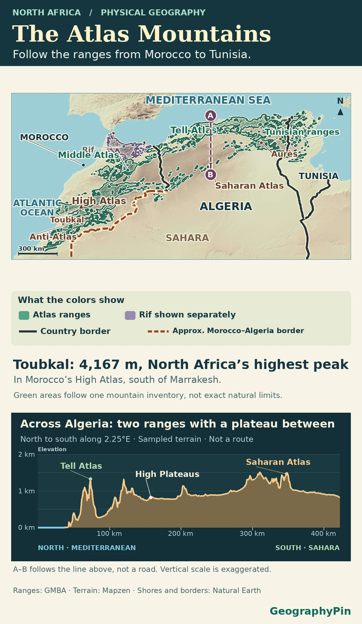
On a regional map, start at Morocco’s Atlantic side, then look east across northern Algeria into Tunisia. That is the broad geographic Atlas used in the European Space Agency’s satellite overview. It is a system of named ranges and the country between them, not a narrow spine you could draw with one line. In Algeria especially, a line joining the highest points would obscure the split into northern and southern belts.
Read the terrain before reading its edges
Use shaded relief to see clusters of ridges, the plains between them and the gradual descent toward the Sahara. Range labels tell you which part of that terrain has a particular name. National borders identify the countries; they do not define where a mountain belt starts or ends. The close-up’s north-to-south order is clearest in Algeria, not a rule that every section from Morocco to Tunisia repeats.
Morocco’s High Atlas and the neighboring ranges
Find Toubkal south of Marrakesh
Jbel Toubkal belongs to the High Atlas, the high inland belt south of Marrakesh. The Moroccan National Tourist Office lists it at 13,671 feet (4,167 meters), the highest summit in North Africa. The High Atlas is one part of the larger Atlas system. The Middle Atlas lies to its north, and the Anti-Atlas is another named belt to its south and southwest.
North of these belts, the Rif follows Morocco’s Mediterranean side. It is separate from the High Atlas, though some broad geological accounts group them within a connected tectonic region. Research in Solid Earth distinguishes the buried rock histories of the coastal Rif and the Middle Atlas. A separate 2025 study of the Central High Atlas found evidence that earlier faults helped guide buried magma intrusions. Similar-looking relief therefore does not establish that adjacent belts share one geological history.
Algeria’s Tell Atlas and the High Plateaus
Read Algeria from the Mediterranean inland
The Tell Atlas is the northern belt, near the Mediterranean. It is made up of several ranges, including Djurdjura in northern Algeria, rather than one ridge along the shoreline. The High Plateaus, also called the Hauts Plateaux, generally separate it from the Saharan Atlas to the south.
Read the lower panel from left to right. Along that north-to-south slice of Algeria, the Tell Atlas rises inland from the Mediterranean. The High Plateaus come next, before the ground rises again in the Saharan Atlas and falls toward the Sahara. The plateaus are high ground between the ranges, not low desert. Melouk and colleagues’ seismic study treats these as three distinct settings.
The Saharan Atlas and the transition into Tunisia
The Saharan Atlas is the more southerly Algerian belt on the side facing the Sahara. It is not another name for Morocco’s High Atlas. Field geologists working at Beni Ounif on the western Saharan Atlas front mapped folds and faults at the foot of the belt. From the mountains outward, foothills and basins mark a transition into the northern Sahara rather than a single mountain-to-desert boundary.
The two Algerian names also do not carry unchanged all the way to the Tunisian coast. Tunisia’s Environment Ministry distinguishes the Tell ranges in the north from the inland Tunisian Dorsale, a chain of uplands that includes Jebel Chambi and extends toward Cap Bon. South of the Dorsale it identifies more scattered mountain units across the high steppes. Look for those local names when zooming in, rather than extending two parallel Algerian lines across all of Tunisia.
Why a geological map draws a different edge
A relief map shows where the land rises. A geological map may mark a boundary where rocks folded or moved along faults, including structures that are not obvious at the surface. Along the Tunisian side, a study using seismic reflection identified a geological front farther east, under the Kairouan–Sahel plains, than earlier work had placed it. That does not mean the plain itself is a surface mountain range.
A third convention is the Global Mountain Biodiversity Assessment inventory. It groups mountains into nested units for scientific comparison, with mapped shapes tied to an explicit definition of mountain terrain. That is useful when you need repeatable study areas, but it answers a different question from the location of a fault or the view of a named range. Unless its rules are given, a precise outline can imply more agreement than exists.
Frequently Asked Questions
Are Morocco’s High Atlas summits snow-covered all year?
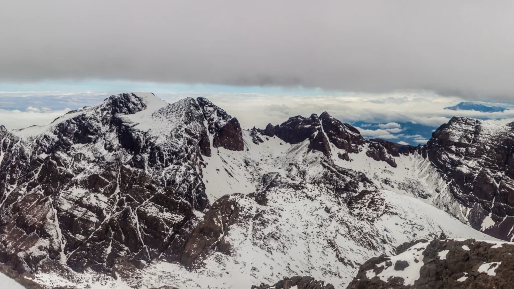
Not generally. A 2026 study using MODIS satellite data and station observations describes seasonal accumulation from late autumn through winter and a progressive spring melt, with large differences between sites. A photo of snow near Toubkal shows conditions on the day it was taken, not a year-round snow line.
What is a chott on maps near the Sahara?
A chott is a salty lowland or lake basin. Satellite research on Algeria’s Chotts Merouane and Melrhir shows why a permanent lake symbol can mislead: those enclosed basins have different patterns of flooding and drying. A chott is a low landform, not another mountain belt or proof that water is present year-round.
Should an atlas label the mountains of southern Spain as Atlas?
Not on an ordinary geographic map. The geographic Atlas across the Maghreb is in North Africa. Tectonic research on the western High Atlas puts the area into a wider Africa–Eurasia convergence setting; such a geological connection does not make the Spanish mountain ranges part of the same named geographic range.
What Did We Learn Today?
The Atlas spans Morocco, Algeria and Tunisia, but its named ranges change as you go east. Toubkal is in Morocco’s High Atlas; Algeria’s Tell Atlas and Saharan Atlas sit on opposite sides of the High Plateaus. Toward Tunisia and the Sahara, local names, relief and geology describe different parts of the transition.
Sources & Data Notes
The regional frame follows European Space Agency imagery and official Moroccan and Tunisian descriptions. Geological fieldwork, seismic studies and the Global Mountain Biodiversity Assessment inventory support the distinction between named surface terrain and a study boundary. Toubkal’s height follows the Moroccan National Tourist Office’s published value.
Photo: Toubkal, high atlas mountains, amine iken, May 8, 2016, CC BY-SA 4.0. Wide panorama cropped to a central view, resized and converted to WebP; adapted image under CC BY-SA 4.0. Map data: Natural Earth, Mapzen Terrain Tiles. The map adapts the GMBA Mountain Inventory v2.0 by Snethlage et al. (CC BY 4.0) to distinguish five named Atlas ranges from the neighboring Rif. The shapes show a geographic convention, not exact natural or political limits. A–B is a north-to-south Mapzen elevation profile along 2.25°E. It exaggerates elevation and is not a road. The dashed southern stretch approximates the agreed Morocco–Algeria boundary. The UN Treaty Collection records the 1972 convention; the African Union boundary report distinguishes agreement from marking the line on the ground. No line of control or boundary involving Western Sahara is plotted.