The Sacramento River flows the length of California’s northern Central Valley, but its meeting with the San Joaquin is nowhere near downtown Sacramento. Downstream of the city, channels wrap around islands before the two river systems come together just east of Suisun Bay.
The Sacramento River begins near Mount Shasta, runs into Shasta Lake, and continues south through the Sacramento Valley. Below the city of Sacramento it turns west through the tidal Delta and meets the San Joaquin system near Sherman Island and Chipps Island. The connected estuary then leads toward San Francisco Bay and the Pacific.
How to use this article: Use the two map boundaries first, then find the Shasta Lake arms, Yolo flood route and western Delta junction.
Source, outlet and drainage basin
The named Sacramento River begins in the mountains near Mount Shasta, not in the city that shares its name. It runs through Shasta Lake, leaves the reservoir at Shasta Dam and crosses the northern Central Valley before joining the San Joaquin system at the Delta’s western end.
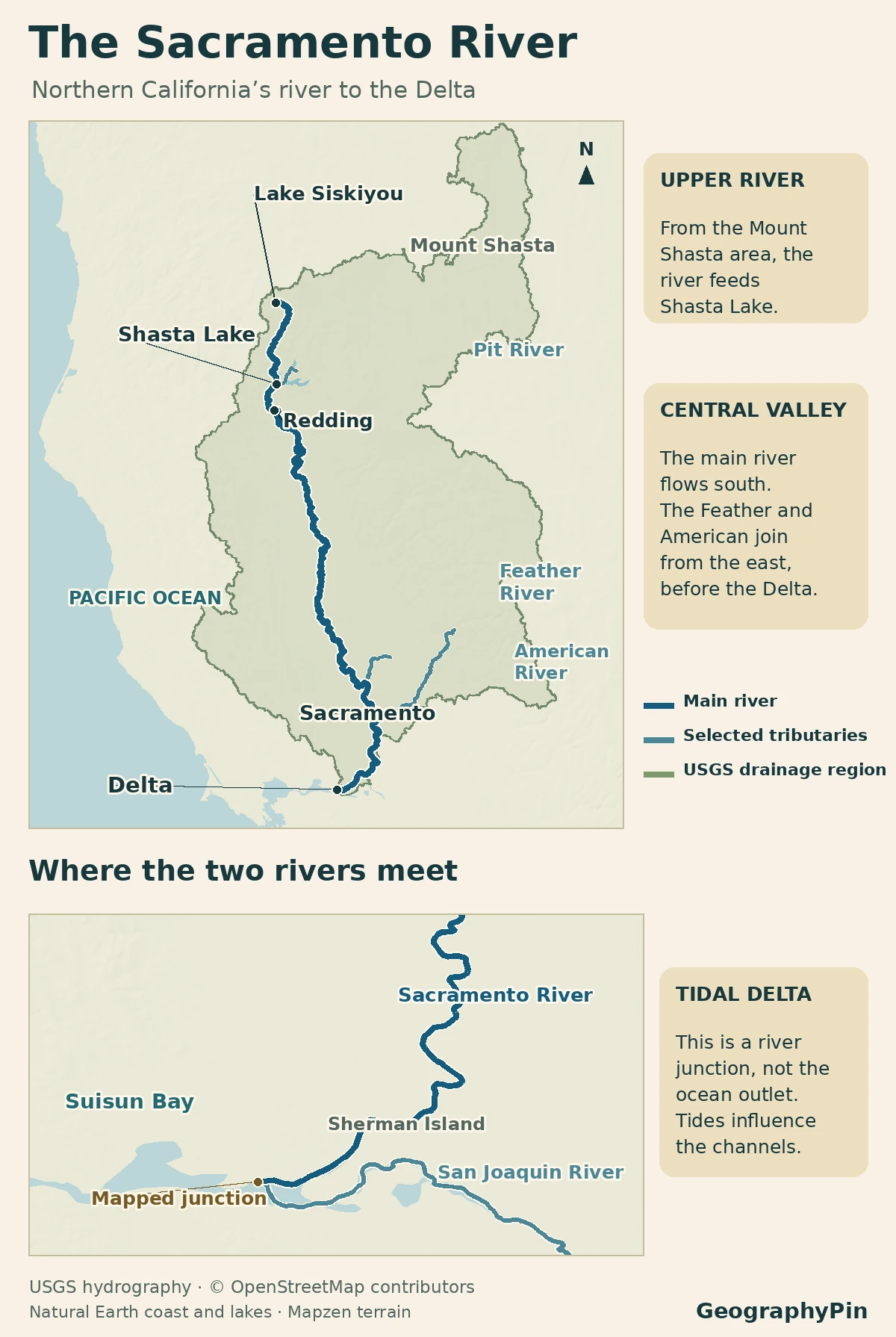
Read the two boundaries
The river line traces a channel; the basin fill shows land upstream that drains toward it. The U.S. Bureau of Reclamation puts the Sacramento basin at roughly 27,000 square miles (70,000 km²). That includes mountain tributaries well east or west of the mainstem. California’s legal Delta is a different geography: a boundary drawn by statute around part of the lower system. The inset shows the junction, not the legal boundary.
The U.S. Army Corps of Engineers lists 447 miles (719 km) for the Sacramento in its Natomas project report, starting at the South and Middle forks. California State Parks gives 375 miles in a general description to the Bay system. Neither publication supplies a common surveyed line and matching downstream coordinates, so the figures should not be treated as equivalent or used to scale this map.
Upper watershed: three rivers reach Shasta Lake
Find the upper Sacramento arm
Near Mount Shasta, the Army Corps identifies the upper Sacramento’s start at the meeting of its South and Middle forks. Follow the named river past Lake Siskiyou and south along the canyon toward Shasta Lake. The Shasta River is a different stream: water draining off the northwest side of the volcano goes toward that river, not the upper Sacramento.
The Sacramento, Pit and McCloud all feed Shasta Lake. On a map, the long Pit arm from the east can look like the obvious continuation of the Sacramento. It belongs to the Sacramento drainage basin, but it is a separately named river. Below Shasta Dam the outlet takes the Sacramento name through Redding and toward Red Bluff.
Sacramento Valley: where two large tributaries join
Past Red Bluff the river leaves the narrower upper country behind and follows the broad valley south. The Feather River, the largest tributary below Shasta Dam, approaches from the east and joins near Verona, north of Sacramento. The American River, also from the east, joins at the city itself. Neither junction is the meeting with the San Joaquin.
Follow the separate flood route
Near the Feather junction, floodwater can leave the Sacramento through the Fremont Weir and move south through the Yolo Bypass, west of the city. It can rejoin the Sacramento system through the Cache Slough area upstream of Rio Vista. The bypass runs across low ground rather than simply tracing the bank of the main river: during high water, a channel-only map misses an important route.
Tidal Delta channels: Sacramento to Suisun Bay
Locate the meeting near Sherman Island
From Sacramento the main channel passes Freeport, then bends west near Rio Vista. It meets the San Joaquin system around the western end of Sherman Island, near Collinsville and Chipps Island. The two approach from different directions, but a close map shows islands and sloughs instead of the clean Y-shape a national map might suggest.
West of the junction the connected waterway opens into Suisun Bay. Water can continue through Carquinez Strait, across the San Francisco Bay system and out through the Golden Gate. Those are downstream estuary waters, not farther sections of the named Sacramento.
The Sacramento itself is freshwater-dominated at Freeport, but tidal motion matters in the Delta. USGS reported about 8,000 cubic feet per second (227 m³/s) at Freeport (station 11447650) during a three-day May 2018 survey. That number describes flow past one station during a particular survey, not the water passing Chipps Island or the daily movement in every tidal branch.
Why the legal Delta and basin do not match
California’s legal Delta includes islands and channels on both river systems. Its administrative boundary can follow levees, district lines, roads and waterways. In contrast, an upstream drainage boundary follows the divides that separate areas draining into different systems. The legal Delta takes in part of the San Joaquin side; it does not take in distant Sacramento tributaries like the upper Feather watershed.
To work out which outline matters, start with the question. If you are tracing how mountain runoff reaches the lower river, look at the Sacramento basin. If you want to know whether a particular island is within California’s legal Delta, use the legal boundary. Neither line tells you how quickly water moves or which direction a current is running at one moment.
Frequently Asked Questions
Is the Sacramento Deep Water Ship Channel the Sacramento River?
No. The ship channel connects the Port of West Sacramento to Delta waters, but much of its course is separate from the bends of the main Sacramento. The mainstem on this map is the river through Freeport and Rio Vista.
Can a change in the Delta alter a quoted river length?
Yes. Changes in channel geometry or the selection of a different end point can change a mapped length. To compare two figures, check that the route starts on the same fork, ends at the same junction, and is measured from a line of similar detail.
Is Suisun Marsh inside the same legal boundary as the Delta?
Do not assume so. The Delta Plan identifies the statutory Sacramento–San Joaquin Delta and Suisun Marsh separately, even though the two are connected by the estuary. The mapped river junction does not show the reach of either legal designation.
What Did We Learn Today?
The Sacramento reaches the San Joaquin in the western Delta, not in the city of Sacramento. Follow the main channel to locate that junction, then use the basin fill to see where the river gathers water. California’s statutory Delta map answers a different question: which land the legal boundary includes.
Sources & Data Notes
Channel and basin context comes from the Army Corps’ Natomas analysis, the Bureau of Reclamation basin report, the USGS study-unit description and its Mount Shasta drainage account. The other length is from California State Parks. California DWR documents the Feather and American junctions; the California Water Commission describes the flood bypass. The Army Corps ship-channel map context, Lower Sherman Island state account, California Water Plan map, legal boundary layer and Delta Plan define the lower features. Freeport discharge is from USGS Scientific Investigations Report 2023–5060; metric values are rounded.
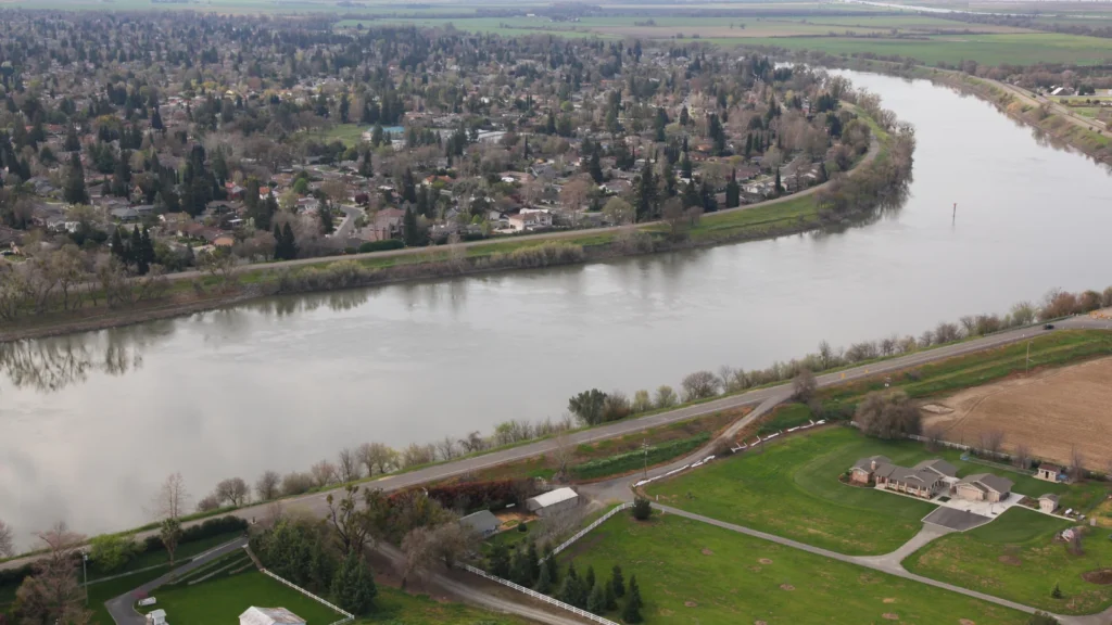
Featured photograph: Sacramento River, Michael J. Nevins, U.S. Army Corps of Engineers Sacramento District, March 17, 2010; U.S. public domain. Cropped, resized and converted to WebP. This historical image shows the Pocket neighborhood and is not a record of current levee conditions.
Prepared for final factual and editorial review by Zurab Koniashvili (Z.K. Atlas). AI tools assisted with editorial preparation.
Map: GeographyPin. Sacramento and lower San Joaquin channel centerlines from OpenStreetMap Sacramento River and San Joaquin River (accessed November 20, 2026; ODbL). The 19 contiguous mapped Sacramento ways have no added links. The two centerlines share a real OSM node west of Sherman Island; Delta Stewardship Council independently confirms this geographic setting. The OSM upstream trace starts at Lake Siskiyou; Mount Shasta represents the broader source area, not the longest headwater. Pit, Feather and American are selected USGS NLDI/NHDPlus paths (12, 19 and 119 continuous reaches), generalized in framing and of different model provenance from the main line. The green tint is USGS Watershed Boundary Dataset, Sacramento HUC 1802; does not assert an equivalence with a separately reported basin area, political boundary or Delta management polygon. Coast and lake overview: Natural Earth public domain. Relief: Mapzen/AWS Terrain Tiles. Delta tidal context: USGS lower Sacramento study. Orientation only; delta shorelines, channels and tides not mapped exhaustively.