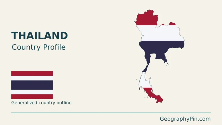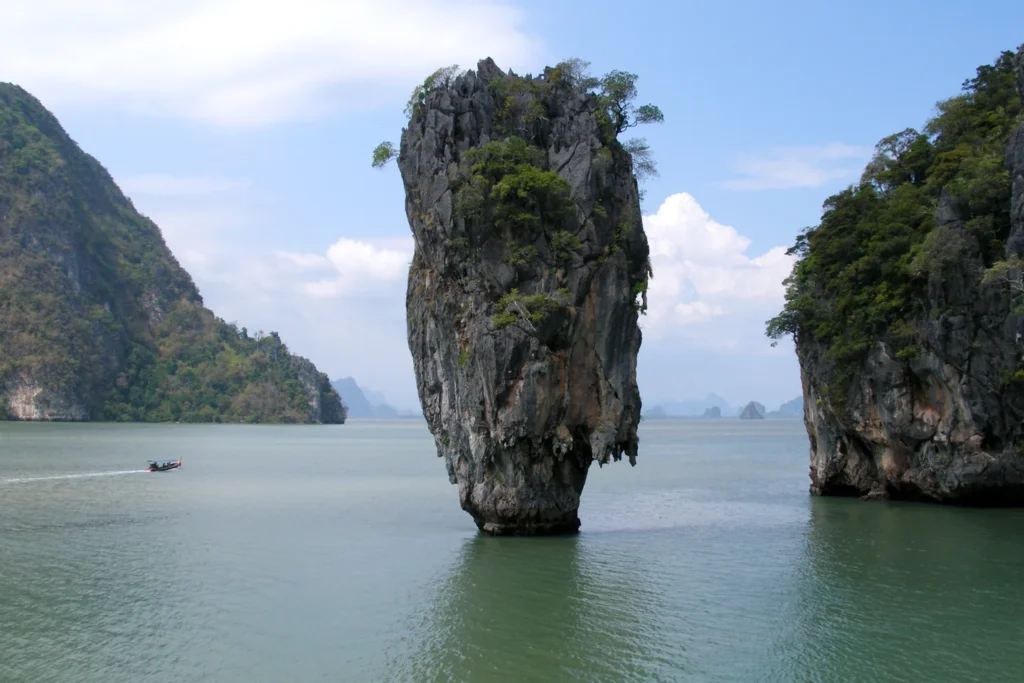
James Bond Island is in Phang Nga Province, Thailand, rather than on Phuket. The attraction’s familiar name also hides a smaller distinction: the isolated rock in the photographs is not the larger island where visitors view it from shore.
One famous name, two distinct landforms
James Bond Island refers to the Khao Phing Kan and Ko Tapu attraction in Phang Nga Bay, northeast of Phuket. Khao Phing Kan is the larger visitor site; Ko Tapu is the separate limestone sea stack offshore. Both are in Phang Nga Province, even when a trip begins in Phuket.
Locate the island in Phang Nga Bay, find the shore facing Ko Tapu, or see where boats may board.
In Phang Nga Province, not on Phuket
James Bond Island lies in Phang Nga Bay, northeast of Phuket, on Thailand’s Andaman side. The Tourism Authority of Thailand locates Khao Phing Kan in Takua Thung District, Phang Nga Province. A trip sold from Phuket does not change the destination’s province.
Departure point and destination are different places
Phuket is a possible starting point. The viewing shore and offshore sea stack belong to Phang Nga Province.
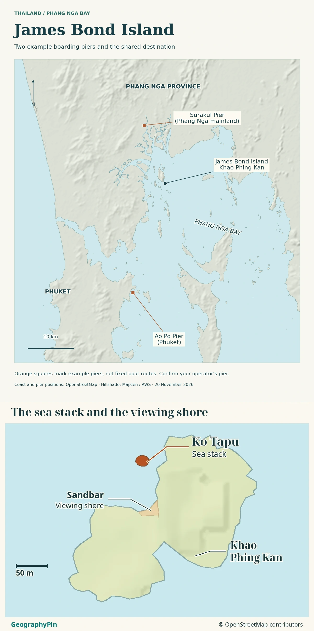
The map below separates Phuket from the Phang Nga mainland and the bay’s islands, then zooms in on the viewing shore and stack.
Khao Phing Kan is the larger visitor site
Khao Phing Kan, also written Ko Khao Phing Kan or Ko Phing Kan, is the larger site beside the photographed pinnacle. Its conspicuous leaning rock and the small shore area are not the same feature as Ko Tapu.
The Tourism Authority of Thailand describes two peaks and a connecting stretch of sand. It places Khao Phing Kan approximately 130 feet (40 meters) from Khao Tapu. That is a useful sense of scale, not a prescribed navigation distance or a promise that the gap can be crossed on foot.
The viewpoint is not on the slender stack
Thailand’s Department of Mineral Resources identifies the sand connection at Khao Phing Kan as the visitor and boat-landing area. It describes viewing Ko Tapu from there or from a boat, not landing on the stack itself.
This distinction explains a familiar photograph: the camera can be on the larger island while the isolated rock fills the frame. A caption calling both simply “James Bond Island” loses the distinction between where a visitor stands and what the visitor sees.
Ko Tapu is a separate limestone sea stack
Ko Tapu, also written Khao Tapu or Ko Ta Pu, is the isolated, narrow-based rock offshore. The Department of Mineral Resources classifies it as a sea stack and places it in the small bay on the north side of Khao Phing Kan.
The department explains the landscape through limestone, fractures and faults, changing sea levels and erosion. Limestone can dissolve in water, while marine processes work on exposed rock. These processes help produce the steep, irregular islands characteristic of the bay.
The stack is therefore not a separate volcanic cone. Nor should its narrow base be explained by waves alone: the geological account includes both the structure of the rock and its subsequent erosion.
Water separates Ko Tapu from the larger island. The sand connection is within Khao Phing Kan, not a beach linking the island to the stack.
Why the James Bond name became attached to the site
The popular name comes from the location’s association with The Man with the Golden Gun, released in 1974. The Tourism Authority of Thailand identifies Khao Tapu as the film location widely known to visitors as James Bond Island.
That nickname is useful for recognizing the destination, but it is less precise than the local landform names. Depending on a photograph or tour description, it may emphasize the stack or the wider stop beside it.
Keep three labels separate: James Bond Island for the familiar attraction name, Khao Phing Kan for the larger island site, and Ko Tapu for the isolated stack. The film reference explains fame, not jurisdiction, geology or access rights.
Phuket and mainland approaches are not one fixed route
Your place of pickup and the pier where you board can be different. Both Phuket and mainland Phang Nga offer approaches to the bay.
| Starting from Phuket | Starting from the Phang Nga mainland |
|---|---|
| Pickup: An included hotel pickup is a road transfer to the pier. | Pickup: A mainland meeting point is not necessarily the pier. |
| Boat boarding example: Ao Po Pier in northeastern Phuket. Ao Po Grand Marina is a different place. | Boat boarding example: Surakul Pier near Ban Krasom. |
| Viewing shore: Check that any included landing is at Khao Phing Kan, not offshore Ko Tapu. | Viewing shore: Ask if the outing lands at Khao Phing Kan or only approaches by boat. |
These are examples of where a boat can board, not a timetable or a guarantee of a direct boat to the islands.
Check the actual boarding pier, not just “from Phuket”
Before committing to an outing, identify the exact boarding place, whether any road transfer is included, the stated landing stop and the return arrangements. A pickup location, a marina and an island destination are three different points.
The map does not show a sailing route. Check the operator’s current arrangements for your travel date.
The protected landscape extends beyond the famous rock
Khao Phing Kan and Ko Tapu belong to the landscape of Ao Phang Nga National Park. The protected setting is not merely the small beach used as a viewpoint. It includes a wider marine and coastal environment with islands, mangroves and tidal habitats.
The official Ramsar information sheet for Pang Nga Bay Marine National Park, dated August 14, 2002, records a site of approximately 154 square miles (400 square kilometers). That is the listed wetland site’s area, not the area of James Bond Island.
Ramsar recognition and national-park management describe related but distinct aspects of protection. Neither makes every part of the bay freely accessible. A simple locator should not be mistaken for a legal boundary map or a permit to land anywhere.
Follow current park directions and the permitted landing arrangements. The existence of a beach, a narrow water gap or a sheltered-looking bay does not by itself establish that landing, swimming or climbing is allowed or safe.
Frequently Asked Questions
Do visitors land on Ko Tapu?
No. Ko Tapu is the narrow offshore stack. Visitors view it from Khao Phing Kan or a boat; a “James Bond Island” landing refers to the larger visitor site, not the rock.
Is Ko Panyi another name for James Bond Island?
No. Ko Panyi is a separate island community in Phang Nga Bay. It may appear in the same tour itinerary, but that does not make it the landing island beside Ko Tapu.
Are Surakul Pier and Kasom Pier different places?
Thailand’s tourism authority uses Surakun and Kasom for the same mainland pier near Ban Krasom. Ask the operator for the exact pin: there are other boarding piers around the bay.
What Did We Learn Today?
Phuket is a possible starting point, not James Bond Island’s province. Khao Phing Kan provides the larger island setting, while Ko Tapu is the isolated limestone stack offshore. Keeping departure place, viewing shore and photographed landform separate makes both the regional map and a visit easier to understand.
Sources & Data Notes
Sources checked November 19, 2026. The approximate separation follows TAT, not a new survey or a navigation rule. The area figure refers to the 2002 Ramsar information sheet. The 2020 Phuket map supports approach geography only, not current services. Current services and permitted landings should be checked with the park and operator.
- Tourism Authority of Thailand: Khao Phing Kan, province and approximate separation
- Thailand Department of Mineral Resources: Ko Tapu, geological setting and viewing location
- Tourism Authority of Thailand: Phang Nga Bay and the film-location name
- Tourism Authority of Thailand: Ko Panyi and mainland bay-tour piers
- Tourism Authority of Thailand: Phuket map, 2020
- Tourism Authority of Thailand: Phang Nga map (pier locator, not a timetable)
- Ramsar: Pang Nga Bay Marine National Park information sheet, 2002
- Tourism Authority of Thailand: 2024 national park landscape overview
Map: GeographyPin original atlas using OpenStreetMap coastlines from November 18, 2026 and local Ko Tapu, Khao Phing Kan and sandbar geometry retrieved November 19, 2026. © OpenStreetMap contributors, ODbL. Shaded relief: Mapzen/AWS Terrain Tiles and its underlying elevation sources. This geographic locator is not a boating, landing or legal boundary chart.
Photograph: Ko Tapu in Phang Nga Bay, © Vyacheslav Argenberg, February 18, 2007, CC BY 4.0. Resized and converted to WebP without cropping.