Saudi Arabia is more varied than a map of sand dunes suggests. A steep mountain margin rises beside the Red Sea, rocky plateaus extend across the interior, and major sand seas occupy parts of the north and south. Cities, oases and coastal routes connect these contrasting landscapes.
Saudi Arabia occupies much of the Arabian Peninsula in Western Asia. Riyadh is its inland capital, while Jeddah lies on the Red Sea. Its geography combines western mountains, the central Arabian plateau, extensive sand deserts and a low eastern Gulf coast. Aridity does not mean an absence of mountains or drainage channels.
How to use this article: Locate Saudi Arabia in the region, compare its main landscapes, understand the water and wadis, or check dated country facts.
1. Where Saudi Arabia Is: Arabia Between Two Seas
The country is not the whole peninsula
Saudi Arabia lies in southwestern Asia, east of the Red Sea and west of the Persian Gulf, commonly called the Arabian Gulf in Saudi sources. The Arabian Peninsula is a broader landmass shared with several other countries; “Arabia” and “Saudi Arabia” are not interchangeable geographical labels.
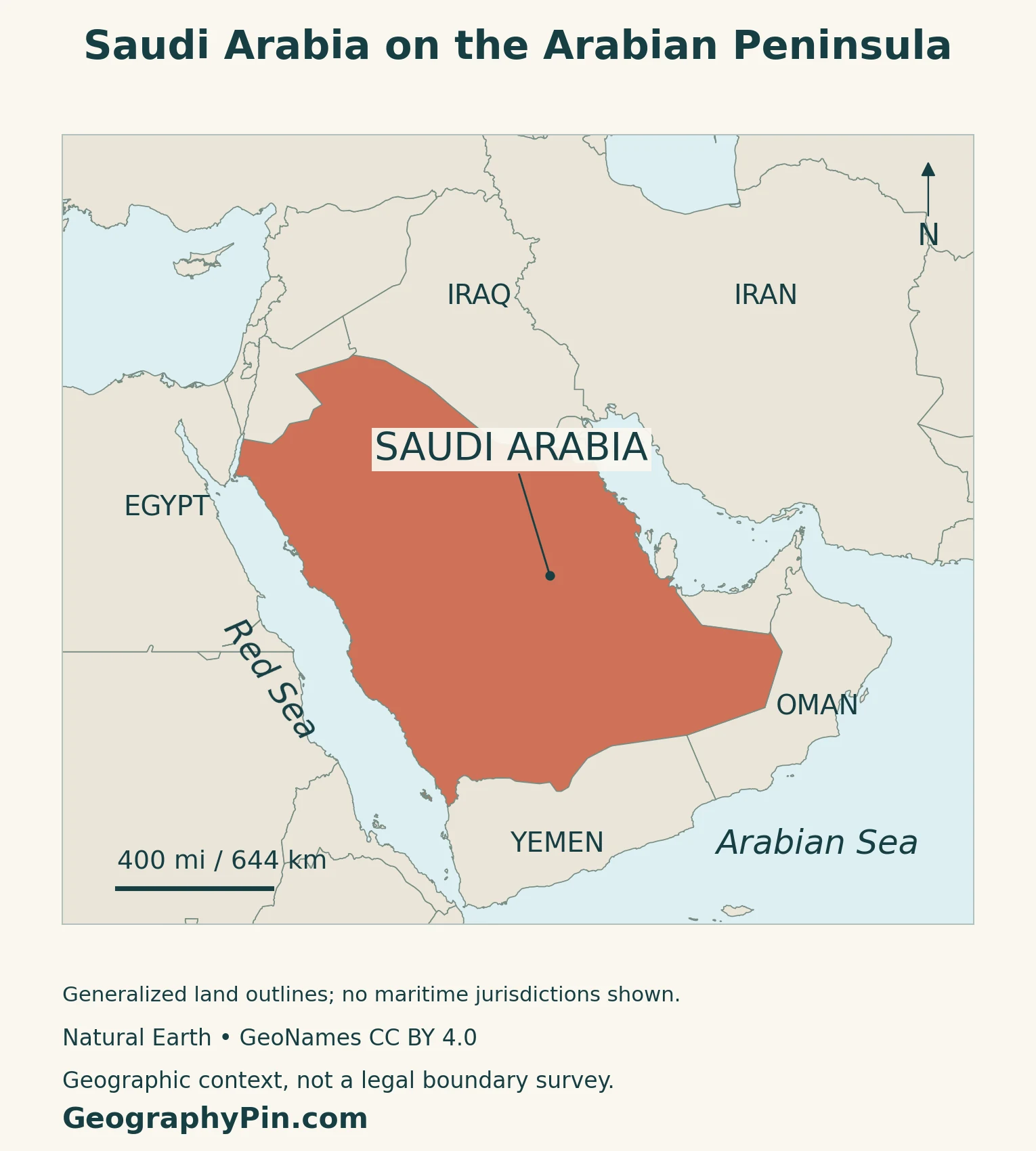
Its mainland neighbors are Jordan, Iraq, Kuwait, Qatar, the United Arab Emirates, Oman and Yemen. Bahrain is an island country connected by a causeway, not another mainland land neighbor. Egypt and Sudan are across the Red Sea rather than across a Saudi land border.
The western coast reaches the Gulf of Aqaba in the northwest. Our Red Sea map explains the two northern gulfs and the sea’s southern connection without confusing them with the eastern Gulf coast.
Saudi Arabia also belongs to the Middle East, a regional label rather than a separate continent. See the Middle East country guide for that definition and the Asia countries and capitals reference for the wider continental setting.
2. Western Mountains, Interior Plateaus and the Gulf Plain
A west-to-east comparison
The western highlands form a long mountain margin above the Red Sea coastal plain. In the southwest, Asir is a particularly important mountain landscape. The slopes facing the Red Sea are generally steeper than the descent toward the interior.
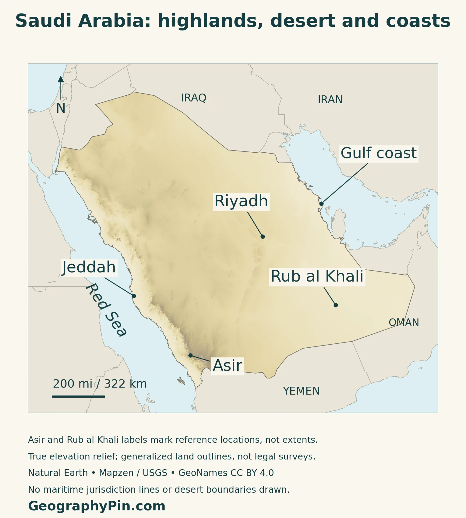
| Setting | Map-reading clue |
|---|---|
| Red Sea margin | Coastal lowlands beside a steep western mountain front |
| Asir highlands | Elevated southwestern terrain, distinct from the coastal plain |
| Central plateau | Broad interior uplands, rocky surfaces and escarpments |
| Gulf coast | Lower terrain on the eastern side |
| Sand seas | Dune-covered areas superimposed on the wider relief |
Desert does not mean loose sand everywhere
The US Geological Survey’s geological synthesis distinguishes ancient crystalline rocks of the Arabian Shield in the west from broad sedimentary formations farther east. In central Arabia, resistant rock layers create escarpments, including the Tuwayq landscape. These are rock-controlled landforms, not simply high dunes.
Farther east, younger deposits cover much lower-relief country. Windblown sand is one surface material within this larger framework; it does not replace the underlying geology. Rocky ground, gravel surfaces, lava fields, valleys and sand dunes can all occur within an arid country.
The physical map shows elevation and relief, not a geological survey or vegetation inventory.
3. Rub al Khali, An Nafud and the Sand Corridor
Three names help organize the desert map
The Rub al Khali, often translated as the Empty Quarter, occupies a large part of southern Arabia. An Nafud is a separate northern sand desert. Ad Dahna forms an elongated corridor of sand between the northern and southern desert systems.
NASA’s description of astronaut imagery shows this relationship clearly: reddish sand in the northern An Nafud continues southeastward into the Ad Dahna corridor. The connection is a geographical pattern of sand deposits, not a river or a road.
The name Empty Quarter describes a desert region, not an administrative province. Its landscape extends beyond Saudi Arabia into neighboring parts of the peninsula. A label inside Saudi territory identifies the Saudi portion; it does not claim that the entire desert falls within one country.
Read the region at the right scale
The Rub al Khali callout marks a reference location rather than tracing the precise edge of every dune field. At country scale, individual dunes are far smaller than the map’s major relief features. Their absence as separate symbols does not mean that the area is flat.
4. Climate, Wadis and the Water Behind Oasis Settlement
Dry conditions still allow runoff
Saudi Arabia’s environment ministry describes the national climate as largely arid to semi-arid, while identifying southwestern Asir as a wetter exception. Elevation, coastal exposure and location produce contrasts within that broad description. A single temperature or rainfall figure would hide those differences.
Mountain terrain and desert climate describe different things. Mountains are landforms; aridity concerns moisture. A mountain region can therefore exist within a generally dry country, while local uplands receive more rain than surrounding lowlands.
Saudi Arabia has no perennial natural rivers. It does have wadis: valleys and channels that can carry runoff after rain. The absence of year-round flow does not mean that rainfall has no route across the landscape or that dry channels are permanent barriers to floodwater.
The country’s Fourth National Communication, submitted in 2022, identifies runoff, shallow and deep groundwater, desalinated seawater and wastewater among its water resources. These are different sources with different roles, not substitutes for a natural river network.
For the fuller explanation of the river criterion and water supply, see the biggest country without a permanent river. This profile keeps the focus on how drainage and settlement fit the wider map.
Al-Ahsa is a managed cultural landscape
Al-Ahsa in eastern Saudi Arabia illustrates the relationship between water and settlement. UNESCO’s World Heritage description includes gardens, springs, wells, canals, a drainage lake, historic buildings and archaeological places within the oasis landscape.
Date-palm cultivation and water-distribution systems are central to that history. The oasis is not simply a patch of vegetation produced without human work: irrigation, farming, maintenance and settlement have shaped it over generations.
A historical spring system should not be taken as evidence that present groundwater supplies are unlimited. The value of Al-Ahsa here is the visible connection between natural water availability and the institutions and labor needed to sustain an agricultural landscape.
5. Riyadh, Population and Country Facts
Riyadh is the inland national capital
The Basic Law identifies Riyadh as the capital and Arabic as the official language. It defines the system of government as a monarchy. Riyadh’s position in the interior distinguishes it from Jeddah on the Red Sea and the cities of the eastern coast.
| Item | Reference |
|---|---|
| Capital | Riyadh |
| Population | 35.3 million, GASTAT estimate for mid-2024 |
| Total area | About 830,000 square miles (2.15 million square kilometers), Ministry of Foreign Affairs figure |
| Official language | Arabic |
| Currency | Saudi riyal (SAR), divided into 100 halalas |
| Government | Monarchy |
| Administrative divisions | 13 regions, subdivided into governorates and local centers |
Residents, citizens and the reference year
The national population estimate includes both Saudi citizens and non-Saudi residents. GASTAT’s mid-2024 publication reports approximately 19.6 million citizens and 15.7 million non-Saudi residents. Citizenship and residence therefore need to be kept separate when interpreting a national total.
The 2022 census counted 32,175,224 people. The later 2024 figure is an estimate, not another census, even when it appears in a report published in 2025. This profile labels the reference year rather than presenting the number as a headcount for the day of reading.
Physical regions and administrative regions differ
The 13 administrative regions are first-level government divisions. Their governorates and local centers belong to a different hierarchy from physical landscapes such as the Najd plateau or Rub al Khali.
Asir can refer to an administrative region as well as a broader mountain setting. On the physical map, the Asir label identifies southwestern uplands rather than drawing the legal outline of the province. The same principle applies to city names: a city marker is not a boundary for its metropolitan area or surrounding region.
6. Jeddah, Trade and Economic Connections
A Red Sea city with a different role from Riyadh
Jeddah lies on the Red Sea coast, whereas Riyadh is inland. UNESCO describes Historic Jeddah as a port linked to Indian Ocean commerce and as a gateway for pilgrims arriving by sea on their way to Makkah. That history connects the city to routes beyond the Arabian Peninsula.
Its historic buildings reflect those connections. Coral-stone construction, tower houses and projecting wooden roshan elements form part of an architectural tradition adapted to the coastal setting and shaped by trade. Jeddah’s port role should not be confused with the national capital function.
Oil and diversification both belong in the picture
The World Bank describes economic diversification away from oil as a central aim of Saudi Arabia’s Vision 2030 agenda. Services, transport, tourism and private-sector development are part of that broader program, alongside the continuing importance of hydrocarbons.
An economic strategy is not the same as a completed transformation. This profile therefore avoids presenting proposed cities or development projects as established population centers. The maps label existing cities and physical regions, not promotional renderings of future infrastructure.
Frequently Asked Questions
Why does Saudi Arabia have both mountains and deserts?
Mountains describe the shape of the land, while desert describes dry conditions. Saudi Arabia’s western mountain margin, interior plateaus and sand seas can all exist within a predominantly arid climate.
Does Saudi Arabia have any rivers?
It has no perennial natural rivers, but it does have wadis and rainfall runoff. Saying simply that there is no drainage would be incorrect.
What Did We Learn Today?
Saudi Arabia combines a high western margin, interior rocky terrain, extensive sand seas and a lower Gulf coast. Water availability helps explain oasis settlement, while Riyadh and Jeddah illustrate different inland and coastal urban roles. Keeping landforms, climate, drainage and administrative boundaries distinct makes the country easier to understand than treating it as one uniform desert.
Sources & Data Notes
Population follows GASTAT’s mid-2024 estimate, including Saudi and non-Saudi residents; it is not a 2026 count. Area follows the Saudi Ministry of Foreign Affairs total-area figure, rounded in the table. The Basic Law supports the capital, official language and monarchy entries. Older geology and imagery sources are used for stable landforms, not present resource reserves or agricultural output. The 2022 climate communication supports water-resource categories, not current supply shares.
- NASA: Rub al Khali extent across southern Arabia
- Saudi Geographical Society, King Saud University: western highlands, coastal plains and interior plateaus
- USGS (1966): stable geological framework of the Arabian Shield, sedimentary escarpments and eastern terrain
- NASA: An Nafud and Ad Dahna in 1996 imagery; used for stable sand-region geography, not current farming claims
- Ministry of Environment, Water and Agriculture: broad arid climate and southwestern Asir contrast
- Saudi Arabia Fourth National Communication (March 2022): perennial-river distinction and water-resource categories
- UNESCO: Al-Ahsa Oasis, irrigation, settlement and cultural landscape
- WIPO Lex: Saudi Basic Law, Articles 1 and 5; capital, language and monarchy
- GASTAT: mid-2024 population estimates, citizens and non-Saudi residents
- Authority for the Care of People with Disabilities: official 2022 census national population reference
- Saudi Ministry of Foreign Affairs: total area; adjacent undated population and rankings not used
- Ministry of Media Saudipedia: 13 administrative regions and subordinate units
- Saudi Central Bank: Currency Law, Article 1; riyal and halala subdivision
- UNESCO: Historic Jeddah, trade, pilgrimage and coastal architecture
- World Bank: diversification agenda and economic context; forecasts not presented as observed outcomes
Map method: Original GeographyPin maps use public-domain Natural Earth country geometry and GeoNames coordinates under CC BY 4.0, selected, reprojected and labeled. Relief uses Mapzen Terrain Tiles and USGS elevation data. Elevation shading does not map vegetation or desert boundaries. Asir and Rub al Khali markers are reference locations, not region outlines; the Gulf coast marker lies on the source shoreline. All eleven source country components are retained. Generalized land boundaries are not a legal survey; no maritime jurisdiction lines are drawn. The decorative feature preserves the complete national flag inscription and sword, following the official flag guide.