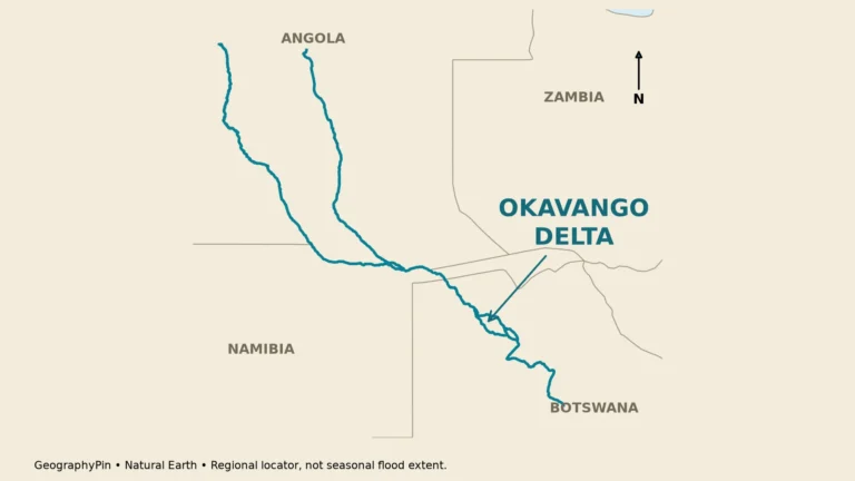
Namibia combines an Atlantic desert coast with inland highlands, seasonal pans and a much wetter northeastern river landscape. Its geography becomes easier to understand when the Namib coast, Windhoek’s plateau setting and the Zambezi Region are read together rather than treated as one desert environment.
Namibia’s coast and interior tell different geographical stories
Namibia is a country in Southern Africa with Windhoek as its capital. The cold Benguela Current and stable atmospheric conditions help keep its Atlantic coast dry, while the interior rises toward a plateau. Eastern Kalahari landscapes, Etosha’s seasonal pan and northeastern rivers add important contrasts to the familiar Namib dunes.
How to use this article: To understand the country, start with Namib versus Namibia, explore why the coast is dry, then compare Etosha’s seasonal water with the Zambezi Region.
1. Where Namibia meets the Atlantic
Namibia lies on the Atlantic side of Southern Africa. Angola borders it to the north, Zambia to the northeast, Botswana to the east and South Africa to the south. Its long, narrow northeastern extension reaches toward the Zambezi River. Namibia does not share a land border with Zimbabwe.
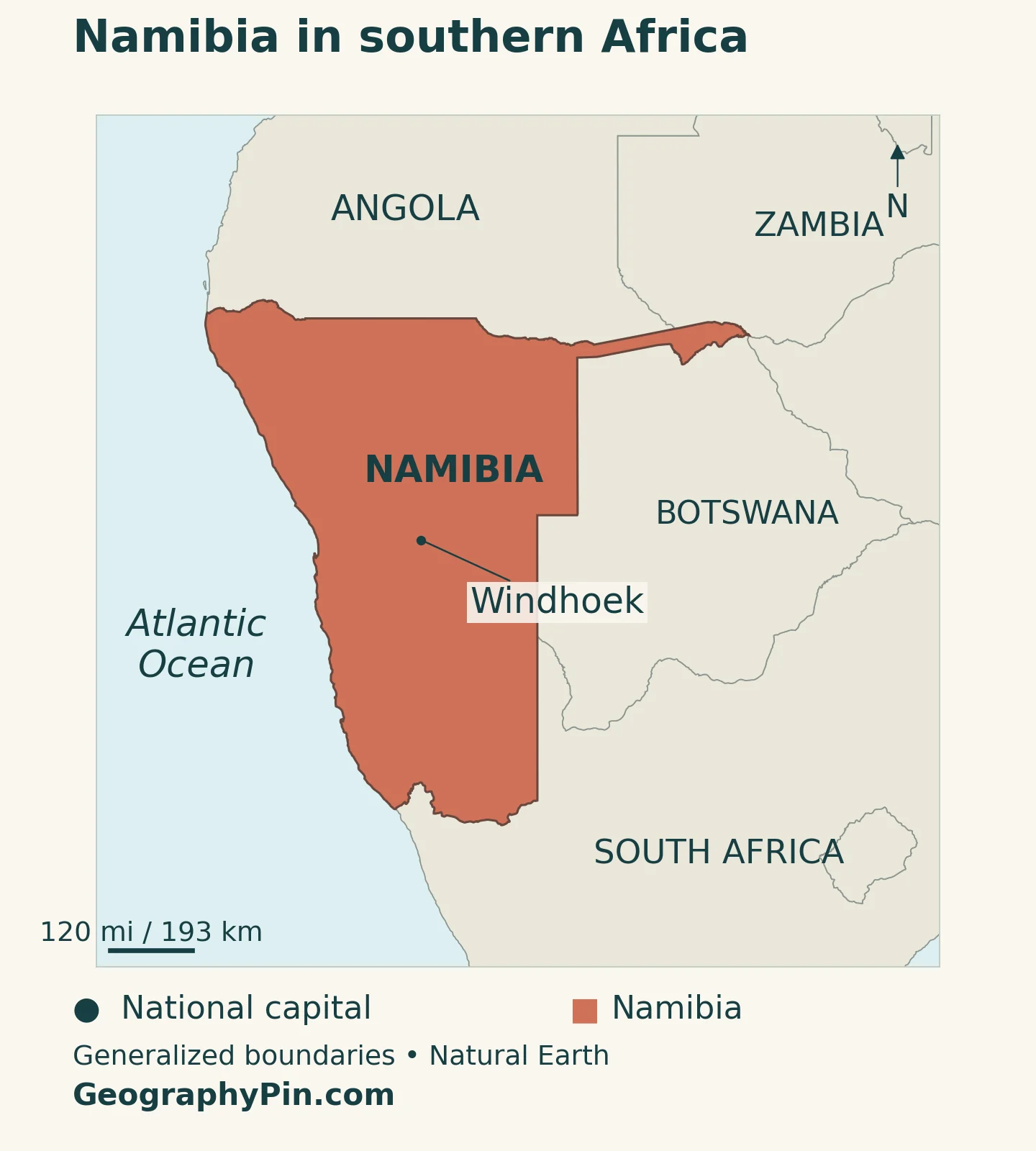
Windhoek, the capital and seat of central government, is inland on the central plateau. It is not a coastal city. Walvis Bay and Lüderitz, by contrast, connect the country with Atlantic shipping routes. These different positions help explain why the capital, ports and river landscapes should not be treated as one geographical setting.
Our Southern Africa countries map places Namibia beside its neighbors. On a national map, follow the coast first, then move inland across the escarpment toward the plateau, and finally northeast toward the river country. This sequence reveals more than a single photograph of desert dunes.
2. Country facts and population reference dates
| Fact | Reference |
|---|---|
| Official name | Republic of Namibia. |
| Capital and government seat | Windhoek, in the central interior. |
| Population projection | 3,187,766 usual residents at midyear 2026, Namibia Statistics Agency medium scenario. |
| Census reference | 3,022,401 people enumerated in the 2023 census, with a reference date of September 24, 2023. |
| Surface area | About 318,623 square miles (825,229 square kilometers), UNData reference year 2023; this is surface area, not land area alone. |
| Official language | English, under Article 3 of the Constitution. |
| Currency | Namibia dollar (NAD). |
| Administration | 14 regions; regional boundaries are not the boundaries of deserts, river basins or other physical regions. |
The population figures answer different questions. The census headline is a de facto count, while the newer projection models the usual-resident population at midyear. The Namibia Statistics Agency adjusted the projection baseline to a July 1 reference date. Consequently, subtracting the census headline from the projection does not give a like-for-like measure of population growth.
The 2026 figure is a medium-scenario projection, not a new census count. Keeping its date and population definition visible makes it more useful than an undated number that changes whenever a different statistical series is consulted.
3. From the Namib coast to the wetter northeast
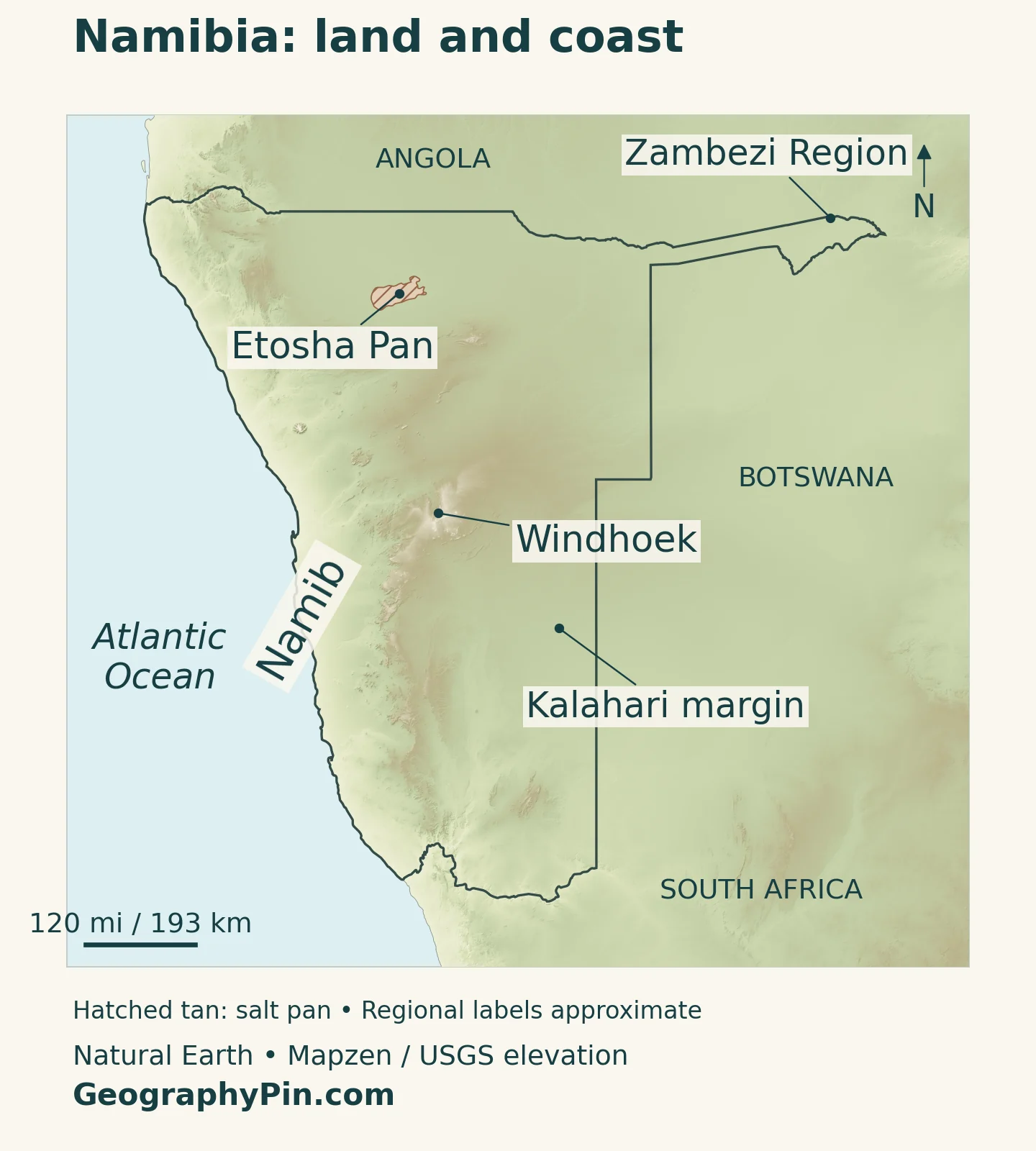
Namibia is not one continuous field of dunes. Its coast includes sand seas, gravel plains and rocky ground; inland, the escarpment and plateau introduce higher terrain. Farther east are Kalahari sandy landscapes, while the north and northeast contain contrasting pans, woodland and river environments.
| Landscape | Where to look | How to recognize it |
|---|---|---|
| Namib coast | Along the Atlantic | An arid coastal environment with dunes in some areas, gravel plains and frequent coastal fog. |
| Escarpment and central plateau | Inland from the coast, including the Windhoek region | A rise from coastal lowlands toward rugged uplands and plateau country. |
| Kalahari margin | Eastern Namibia | Sandy inland landscapes that can support grasses, shrubs and trees rather than uninterrupted bare dunes. |
| Etosha | Northern interior | A large saline pan and surrounding habitats, with water coverage varying between dry and wet conditions. |
| Northeastern river country | Kavango areas and the Zambezi Region | Wetter landscapes and major cross-border rivers, distinct from the Atlantic desert coast. |
The Namib is a landscape, not another name for the country
The similarity between “Namib” and “Namibia” can hide an important distinction. Namibia is the sovereign country; the Namib is a desert region associated with the southwestern African coast. A country outline therefore cannot be used as the desert’s boundary.
The UNESCO-listed Namib Sand Sea is a particular part of that wider desert. Its dunes, interdune areas and other habitats form a landscape in which fog is an important source of moisture. Neither the World Heritage property nor a photograph of its dunes represents all of Namibia.
Moving inland changes the view. The plateau around Windhoek belongs to a different setting from the sand sea, while the Kalahari margin introduces another extensive sandy environment. Sand alone is not enough to identify a place: vegetation, relief, moisture and regional position all matter.
4. Why an Atlantic coast can be so dry
Cold water, stable air and coastal fog
Being next to an ocean does not guarantee abundant rainfall. Along Namibia’s coast, the cold Benguela Current and the regional subtropical high-pressure system help produce a stable atmosphere. Cold near-surface air and descending air aloft discourage the strong upward motion needed for substantial rain-cloud development.
Fog can nevertheless form close to the ocean and move inland. This is why a cool, misty coast can border an extremely dry desert. Fog supplies moisture to organisms adapted to it, but it does not turn the coastal desert into a regularly rain-fed landscape. The distinction between fog and rainfall is essential to understanding the Namib.
The country’s inland climate is different. Summer moisture generally becomes more important toward the north and northeast, while the coast remains strongly influenced by the ocean. Namibia’s national climate report identifies the seasonal movement of tropical rain-bearing systems as part of this contrast.
Season and location both change the experience
Much of Namibia receives its rain in the warmer part of the year, broadly from November to April, although rainfall is variable and the far south also has winter-rain influences. This is a regional pattern, not a promise of rain at a particular place or on a particular date.
Altitude also matters. Inland winter nights can be cold even when daytime conditions are sunny, and a coastal town may feel cool while the interior is hot. A single national temperature or a simple “desert climate” label misses these differences. For a map reader, distance from the sea, elevation and latitude are all useful clues.
5. Rivers, Etosha and the northeastern corridor
Many inland channels in Namibia carry water only intermittently. Several major perennial rivers occur along or near the country’s edges: the Kunene in the northwest, the Okavango in the north, the Zambezi and Kwando in the northeast, and the Orange in the south. Their catchments extend beyond Namibia, making upstream conditions important.
These rivers should not be confused with a network carrying dependable year-round water across the entire interior. Groundwater, local seasonal flows and water-supply infrastructure are also important. A river line on a small map shows location, not a guarantee that every reach is flowing at the moment a reader visits.
Etosha is not a permanent blue lake
Etosha Pan is a saline depression whose appearance changes with water conditions. Large dry surfaces can dominate, but wet periods can bring shallow flooding. Water may arrive through the wider drainage system as well as from rain falling directly on the pan.
NASA satellite observations illustrate this variability: a dry-looking pan in late 2019 was followed by extensive surface water in early 2020 and drying later that year. Those images describe particular dates, not an annual timetable that repeats exactly. The pan, its surrounding habitats and Etosha National Park also have different boundaries.
The Zambezi Region is an administrative area, not the whole river basin
The Zambezi Region occupies the far northeastern part of Namibia, with Katima Mulilo as its regional center. The long northeastern extension is not all one region: its western part includes territory in Kavango East. Treating the entire extension as the Zambezi Region obscures this distinction.
The river’s basin is much larger and crosses national borders. Our Zambezi River guide follows that wider system. A regional boundary, a national frontier and a drainage divide serve different purposes, even when they appear close together on a map.
6. Windhoek, ports and regional government
Windhoek’s constitutional role gives it national significance beyond its position on the plateau. It is the seat of central government, while the country’s 14 regions provide a separate administrative framework. Physical labels such as “Namib” or “Kalahari” do not replace those regional names.
English is the constitutional official language. That legal status should not be read as a claim that everyone speaks only English or that Namibia has a single linguistic identity. An official-language field in a reference table describes government status, not the full range of languages used in homes and communities.
On the coast, Walvis Bay and Lüderitz have a different function. Namport, the national ports authority, manages both ports. Their significance comes from maritime access and the connections between harbors, inland roads and regional trade corridors, rather than from being national capitals.
This creates a useful contrast: Windhoek concentrates central-government functions inland, while the ports provide sea access. Northern and northeastern settlements add another dimension shaped by regional administration, local livelihoods and river landscapes. No single city or desert photograph can stand in for all these settings.
7. How geography shapes the economy
Mining is a major part of Namibia’s economy and export earnings. Services, including transport, trade and finance, also matter, while agriculture and tourism support livelihoods and employment. Describing the country only through mineral extraction therefore leaves out important parts of its economic geography.
Ports help connect inland production with overseas markets. Transport corridors also serve trade beyond Namibia, so the influence of a coastal harbor reaches farther than the neighboring city. This is one reason that a dry coastal environment can still contain major infrastructure and commercial activity.
Water availability creates a different kind of constraint. Rainfall variability, intermittent inland drainage and dependence on shared rivers make water management important across farming, towns and industry. The wetter northeast and the arid coast do not face identical conditions, so a national average is a poor substitute for local context.
Tourism draws on that diversity: dune landscapes, wildlife habitats, the plateau and northeastern rivers offer different experiences. Understanding the country means connecting these places rather than reducing Namibia to a single desert scene.
Frequently Asked Questions
Why is Namibia’s coast dry despite being beside the Atlantic?
The cold Benguela Current and regional high-pressure conditions help stabilize the atmosphere and inhibit substantial rainfall. Fog can occur without the regular rain needed to produce a humid coastal landscape.
Does the Namib Desert cover all of Namibia?
No. Namibia also contains plateau and escarpment terrain, Kalahari landscapes, pans and wetter northern and northeastern environments. The country and desert have different boundaries.
Is Etosha Pan a permanent lake?
No. It is a saline pan with variable water coverage. Dry conditions can leave broad exposed surfaces, while wetter periods can bring shallow flooding.
What Did We Learn Today?
Namibia’s geography links a dry Atlantic coast, inland highlands, Kalahari landscapes, Etosha’s changing pan and northeastern rivers. Windhoek is the inland capital, while coastal ports provide maritime connections. Cold ocean water, atmospheric stability and regional rainfall differences explain why one country contains such contrasting environments.
Sources & Data Notes
The 2026 population is the national medium-scenario projection for midyear usual residents. The 2023 census headline is a de facto enumeration with a September 24 reference date; the two figures are not directly comparable population bases. Surface area follows UNData’s 2023 reference, rounded after conversion to square miles. Satellite examples describe their observation dates, not current flooding. Etosha’s tentative-list entry is not an inscription as a World Heritage property.
- Namibia Statistics Agency: National Population Projections 2023–2053, methodology and Table 3.17
- Namibia Statistics Agency: 2023 census main-report release, October 2024
- UNData: surface area, capital and currency
- Constitution of Namibia: Articles 1 and 3
- Regional Councils Act: Schedule 1, regions and regional centers
- Namibia Tourism Board: principal physical landscapes
- Namibia Tourism Board: regional climate and seasons
- Republic of Namibia: first Biennial Transparency Report and fifth National Communication, climate and water context
- NASA Earth Observatory: Benguela Current, coastal fog and inland relief
- UNESCO: Namib Sand Sea and fog-supported habitats
- NASA Earth Observatory: observed wet and dry conditions in Etosha Pan
- UNESCO tentative-list description: Etosha Pan and its water inputs
- Namport: Port details, management of Walvis Bay and Lüderitz, and road connections
- World Bank: mining, services and livelihood sectors
Map method: Original GeographyPin maps use public-domain Natural Earth boundaries, populated places and Etosha salt-pan geometry. Shaded relief uses Mapzen Terrain Tiles with USGS SRTM and GMTED2010 data. Terrain colors indicate elevation, not vegetation. Etosha hatching shows a generalized pan surface, not permanent water or the national park boundary. The Zambezi Region pointer uses Katima Mulilo’s location rather than a drawn regional perimeter; Namib and Kalahari labels are broad guides. Web Mercator scale varies with latitude. Generalized borders near Kazungula do not establish a Namibia–Zimbabwe border or an exact four-country meeting point; enlarging the image does not restore missing boundary detail. The cover is an original flag-and-outline design.