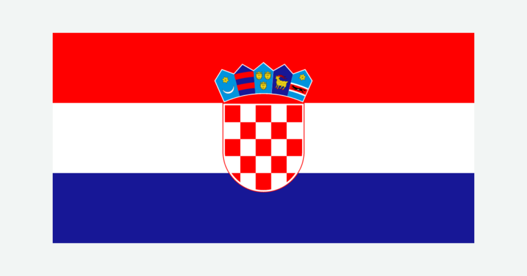
Croatia is often pictured as a line of Adriatic towns and islands, but that view leaves out much of the country. Inland plains, river corridors and mountain country give it a second, continental face. The contrast helps explain why its coastline is so intricate, why Zagreb is not a seaside capital, and why Croatian rivers do not all flow toward the nearby Adriatic.
Croatia lies along the eastern Adriatic and extends inland into the Pannonian region. Zagreb is its capital. Its main landscapes are coastal and island Croatia, the mountainous Dinaric belt, and inland lowlands. Bays, peninsulas and numerous island shores give the country a long, intricate coastline relative to its land area.
How to use this article: Compare the three physical settings, see why coastline measurements differ, or follow rivers and underground water.
1. Locate Croatia and its Adriatic coast
Croatia borders Slovenia, Hungary, Serbia, Bosnia and Herzegovina, and Montenegro on land. Its coast faces the Adriatic Sea, the northern arm of the Mediterranean between the Italian and Balkan peninsulas. Italy lies across the sea; it is not a Croatian land neighbor.
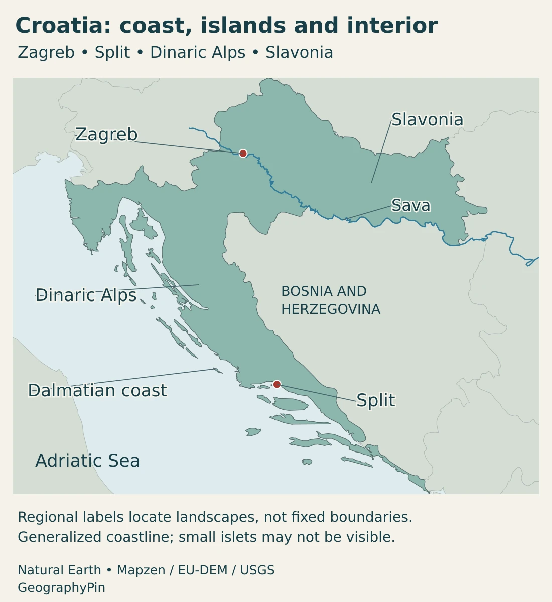
The country’s outline bends from the continental interior toward a long coastal strip. Slavonia lies in the east, while Istria projects into the northern Adriatic and Dalmatia extends along much of the southern coast. These geographic and historical names help describe the country, but are not one uniform set of present-day administrative units.
Near Neum, Bosnia and Herzegovina has its own short Adriatic frontage. Croatia’s Pelješac Bridge, opened in 2022, provides a road connection via the Pelješac peninsula that avoids crossing that corridor. The bridge changes the transport route, not the international border or Bosnia and Herzegovina’s coastal access.
Croatia can be understood in both Central European and Mediterranean settings. A map of the Balkan region offers another regional perspective, but regional labels should not hide the country’s inland–coastal contrasts.
2. Country facts and Zagreb
| Item | Detail |
|---|---|
| Capital | Zagreb |
| Population | 3,874,993 residents at mid-2025; Croatian Bureau of Statistics estimate published September 4, 2026. |
| Statistical land area | About 21,851 sq mi (56,594 km²); the official statistical figure excludes separately reported marine territory. |
| Government | Parliamentary republic |
| Official language and script | Croatian and the Latin script; other languages and scripts may also be in local official use under law. |
| Currency | Euro (€), adopted January 1, 2023. |
| County-level structure | 20 counties and the City of Zagreb, which has county status. |
Population is a mid-2025 estimate, not a 2026 census. Area follows published national statistics based on State Geodetic Administration data; it is not a new 2025 survey or a claim that every inland water surface has been excluded. Square miles are rounded.
The estimate builds on the 2021 census usual-residence population and subsequent births, deaths and migration. It describes residents, not all Croatian citizens worldwide. Its publication year and population reference year are different.
The City of Zagreb and Zagreb County are separate statistical and administrative units. The city had an estimated 777,744 residents at mid-2025; that figure should not be substituted for the population of the surrounding county or a wider metropolitan area. The Constitution identifies Zagreb as the national capital.
3. Coast, Dinaric mountains and Pannonian lowlands
Three settings explain the country’s shape
| Setting | Landscape | Geographic significance |
|---|---|---|
| Pannonian and adjoining inland country | Lowlands and river plains, especially in Slavonia, with hills and uplands around them. | Links Croatia with the Sava, Drava and Danube corridors rather than only the sea. |
| Dinaric mountain belt | Mountain ranges and karst landscapes, including Gorski Kotar and Lika. | Separates and connects inland and coastal settings through passes, valleys and transport routes. |
| Adriatic coast and islands | Indented shoreline, peninsulas, channels and numerous islands; mountains approach much of the coast. | Creates many coastal environments within a comparatively narrow land belt. |
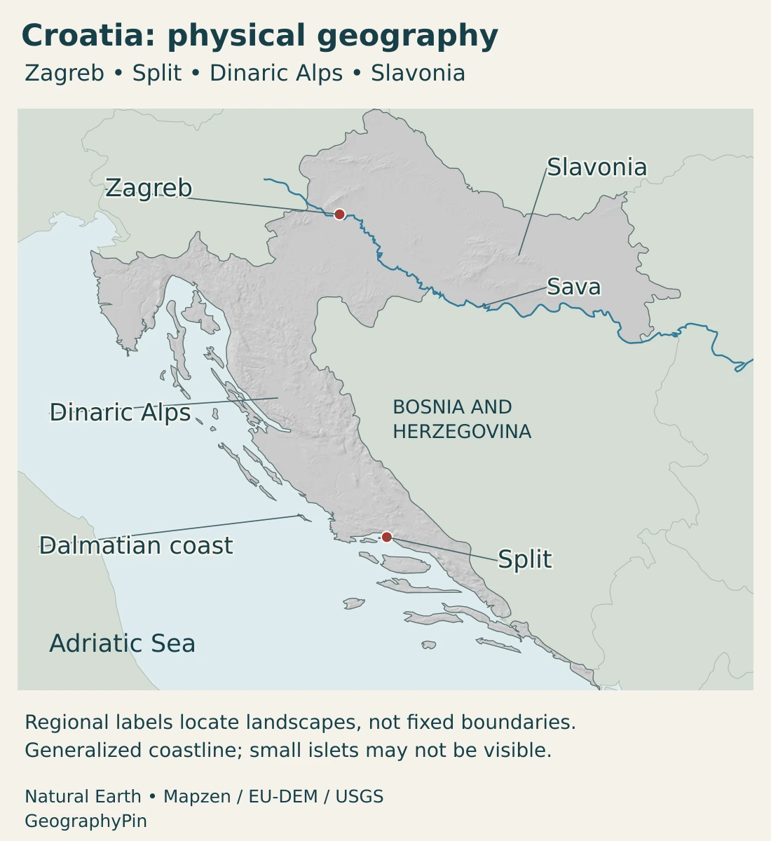
These broad settings overlap at their edges. Slavonia is not a perfectly flat rectangle, and coastal Croatia is not a continuous beach. Inland hills interrupt the plains; on parts of the Adriatic frontage, steep relief rises close behind coastal settlements.
The Dinaric belt is especially important for karst, where water dissolves carbonate rocks and circulates through fissures and underground passages. Caves, depressions and springs can be as important to understanding drainage as visible surface streams. This is a landscape process, not simply a synonym for bare rock.
Why is Croatia’s coastline long for its size?
A coastline follows the edge of the land, not a straight line between the country’s northern and southern ends. Croatia’s many bays and peninsulas add length to the mainland shore. Counting the shores of its islands adds much more, without adding a comparable amount of land area.
Geology and changing sea level help explain the pattern. Rising seas flooded parts of an already uneven, karstified eastern Adriatic landscape. Higher ground remained above water while lower areas became channels and submerged depressions. Research on Croatian coastal basins records this drowning of earlier landforms; it was not a coastline created by one modern event.
The ministry responsible for island development lists 1,244 islands, islets and rocks combined. That is not a count of 1,244 large or inhabited islands. It is also not the number of shapes that will remain visible on a small national map, where very small features may disappear at screen scale.
There is no useful single coastline number without a definition. Mainland-only and mainland-plus-islands totals measure different things. Map resolution also matters: a detailed line follows more small indentations than a simplified one. Compare the scope and method before treating two published lengths as a disagreement.
4. Climate, rivers and karst water
Croatia has continental, mountain and maritime climatic settings. Inland areas experience temperate continental conditions, while the Adriatic moderates coastal temperatures. Mountain areas are generally colder and retain snow longer than adjacent lower terrain.
The distinction is not just a north–south gradient. The Dinaric mountains alter airflow and precipitation, so places a short distance apart can have different conditions. Coastal summers commonly have a drier Mediterranean pattern, but the shore still experiences changing weather and is not permanently warm or calm.
The Sava looks toward the Danube; karst adds hidden routes
The Sava connects Croatia with the wider Danube basin. It passes through the Zagreb area and continues downstream to join the Danube at Belgrade. Water in this system ultimately reaches the Black Sea, not the Adriatic, despite Croatia’s well-known Mediterranean coast.
The international basin is shared across several countries. Its management involves floodplains, river habitats, navigation and water quality, not simply the main channel. A country profile needs this inland river connection as well as the more familiar coastal view.
Karst adds another layer. At Plitvice Lakes, water interacts with limestone and dolomite, and the relationship between permeable and less permeable rocks helps shape where water flows or collects. A map showing only visible rivers cannot describe every underground connection.
The lakes and cascades also illustrate deposition as well as dissolution. Calcium carbonate carried in the water can form porous tufa barriers, with biological processes contributing to their growth. These barriers help create the stepped lake system. Karst therefore includes places where rock is removed and places where new mineral deposits accumulate.
5. People, cities and languages
Zagreb is an inland capital associated with the Sava corridor. Split occupies a coastal setting in Dalmatia, while Rijeka is a northern Adriatic port. Their different locations show why Croatia’s urban geography cannot be reduced to one string of seaside destinations.
Coastal cities also connect with island communities, whose transport needs include sea crossings. An island may be close to the mainland on a national map but still depend on a different combination of transport links from an inland town. Distance, terrain and the presence of a water crossing are separate practical constraints.
The contrast between Zagreb city and its surrounding county is particularly important when reading population data. A named city, an administrative unit and a built-up urban area are not automatically the same place statistically. Using the same reference date and boundary is essential for a fair comparison.
Croatian and local language rights
The Constitution establishes Croatian and the Latin script in official use. It also allows other languages and scripts to be introduced into official use in individual local units under conditions set by law. National official-language status and local minority-language rights can therefore coexist.
That legal description is different from saying that every resident speaks only one language. It also does not make every minority language official everywhere in the country. The level and place of official use matter.
6. Government and geographic economic connections
Croatia is a parliamentary republic, with a prime minister as head of government and a president as head of state. It joined the European Union in 2013 and adopted the euro in 2023. Older references to the kuna describe an earlier currency arrangement, not the current one.
Tourism makes the coast especially visible in economic statistics. In 2025, the Adriatic statistical region accounted for 94.3% of tourist nights in commercial accommodation. This measures overnight stays in that accommodation category, not the share of all Croatian economic output, all visitors or all forms of accommodation.
The concentration shows why the island-rich coast matters economically, but it does not make the interior irrelevant. Zagreb and other inland centers have their own urban functions, while the country’s river and land connections place it within wider European networks.
Rijeka provides a different example of coastal importance. Its port links maritime cargo with inland markets and rail connections in Central and Eastern Europe. A port’s geographic role extends beyond the waterfront: it depends on how ships, terminals and land transport fit together.
The Pelješac Bridge illustrates another way geography shapes infrastructure. A sea crossing can improve continuity along a narrow coastal country without changing political boundaries. Together, inland rivers, mountain routes, island connections and Adriatic ports explain more of Croatia than coastline length alone.
Frequently Asked Questions
Why is Croatia’s coastline long compared with its area?
Its mainland shore is highly indented, and many islands add their own shorelines. Coastline totals depend on whether island shores are included and how closely small bends are measured; land area measures something different.
What are Croatia’s main physical regions?
The broad contrast is between inland Pannonian lowlands and adjoining hills, the Dinaric mountain belt, and the Adriatic coast and islands. These are physical settings, not three administrative provinces.
Is Zagreb on the Adriatic coast?
No. Zagreb is inland, in the Sava setting. Split and Rijeka are coastal cities, but neither replaces Zagreb as the constitutional capital.
What Did We Learn Today?
Croatia combines an intricate Adriatic coast with Dinaric mountains and inland Pannonian landscapes. Its islands lengthen the shoreline, while karst shapes both surface and underground water. Zagreb and the Sava connect the country with continental Europe and the Danube basin. Clear definitions of coastline, island counts and population boundaries make its country facts more useful.
Sources & Data Notes
- Croatian Bureau of Statistics — Population estimate, 2025. September 4, 2026 release: mid-2025 population 3,874,993 and City of Zagreb 777,744, based on usual residence and demographic changes since the 2021 census.
- Croatian Bureau of Statistics — Statistical Information 2025. Published statistical land area 56,594 km², separately from marine territory. The underlying State Geodetic Administration spatial database is dated in table footnotes, not a new 2025 survey.
- Croatian Parliament — Constitution. Article 12: Croatian and Latin script, with local official use of other languages and scripts under law. Article 13: Zagreb as capital.
- European Union — Croatia. Parliamentary system, EU membership, euro adoption and county-level administration.
- Miroslav Krleža Institute of Lexicography — Geography and population. Inland, mountain and Adriatic regional setting.
- Miroslav Krleža Institute of Lexicography — Relief. Pannonian, Dinaric and coastal physical settings; karst and the relationship between mountains and coast.
- Ministry of Regional Development and EU Funds — Croatian islands. Combined total of 1,244 islands, islets and rocks; not a count of large or inhabited islands. Ministry information consulted in November 2026.
- Ilijanić and colleagues — Sea-level rise and karst basins on Pag. 2022 original sedimentary research on coastal lakes and wetlands, sea-level change and drowned eastern Adriatic landforms.
- DHMZ — Climate of Croatia. Continental, mountain and maritime climates, including elevation and relief influences. General climatic setting, not a current weather forecast.
- International Sava River Basin Commission — Basin analysis. 2009 report used for enduring river geography and international basin relationships, not current water-quality or economic statistics.
- Plitvice Lakes National Park — Karst landscape. Carbonate rocks, fissure flow, dissolution and the hydrogeological setting of the lakes.
- Plitvice Lakes National Park — How tufa is formed. Calcium carbonate deposition and biological contributions to tufa barriers.
- Croatian Bureau of Statistics — Commercial tourism, 2025. Adriatic statistical region accounted for 94.3% of commercial-accommodation tourist nights in 2025; not a GDP share or all-accommodation measure.
- Luka Rijeka — Geographical position. Port connections with inland Central and Eastern European markets and rail infrastructure.
- European Commission — Pelješac Bridge. Bridge opened in 2022 and transport connection avoiding the Neum corridor; no change of international sovereignty implied.
Map sources and scope: Original GeographyPin maps use public-domain Natural Earth country outlines, city coordinate attributes and actual Sava river geometry. All Croatian country components in the source are retained. Small islands are generalized and may not be distinguishable at screen scale; this is not a complete island inventory or a basis for calculating coastline length.
Regional labels identify broad landscapes, not administrative units or fixed boundaries. Zagreb and Split markers show source locations, not municipal limits. The Neum interruption in Croatia’s land outline is retained; the bridge is not drawn as a land connection. Generalized national boundaries are not legal delimitation, and no maritime boundaries or claims are mapped.
Hillshade is calculated from real elevations accessed through Mapzen Terrain Tiles. Produced using Copernicus data and information funded by the European Union, EU-DEM layers; global elevation data courtesy of the U.S. Geological Survey. Elevation-source attribution and terms apply. Shading shows terrain form, not elevation classes or local navigation detail.
The cover uses Croatian national flag artwork in a country-outline motif, with an intact flag preserving the coat of arms, a divider and GeographyPin branding.