Japan’s crowded urban corridors and mountainous interiors are two sides of the same geographic story. The key is not simply how much territory the country has, but where its flatter land, river mouths, sheltered bays and transport connections are located.
Japan is an East Asian island country in the western Pacific, with Tokyo as its capital. Its main islands are Hokkaido, Honshu, Shikoku and Kyushu. Extensive mountains leave limited lowland space, helping explain the concentration of cities and infrastructure on plains, while latitude, elevation and seasonal winds create pronounced climatic differences.
How to use this article: Check what the area figure includes, understand why plains matter so much, or distinguish Tokyo from its wider metropolitan region.
1. Locate Japan and understand its island geography
Japan lies offshore from the eastern edge of Asia. The Pacific Ocean opens to its east, while the Sea of Japan separates much of the archipelago from the Asian mainland. The island chain extends broadly from northeast to southwest rather than forming one compact block of territory.
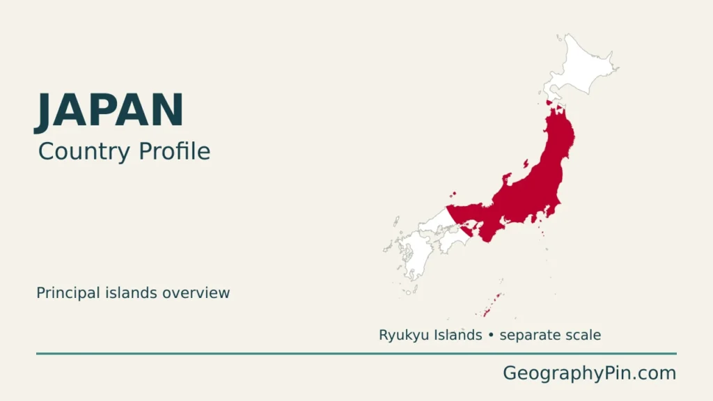
Honshu is the largest of the four main islands and contains Tokyo, Nagoya and Osaka. Hokkaido lies to its north; Shikoku is south of western Honshu, and Kyushu lies farther southwest. The Ryukyu island chain continues southwest toward Taiwan, including Okinawa. These locations connect Japan to the wider geography shown on our East Asia countries map.
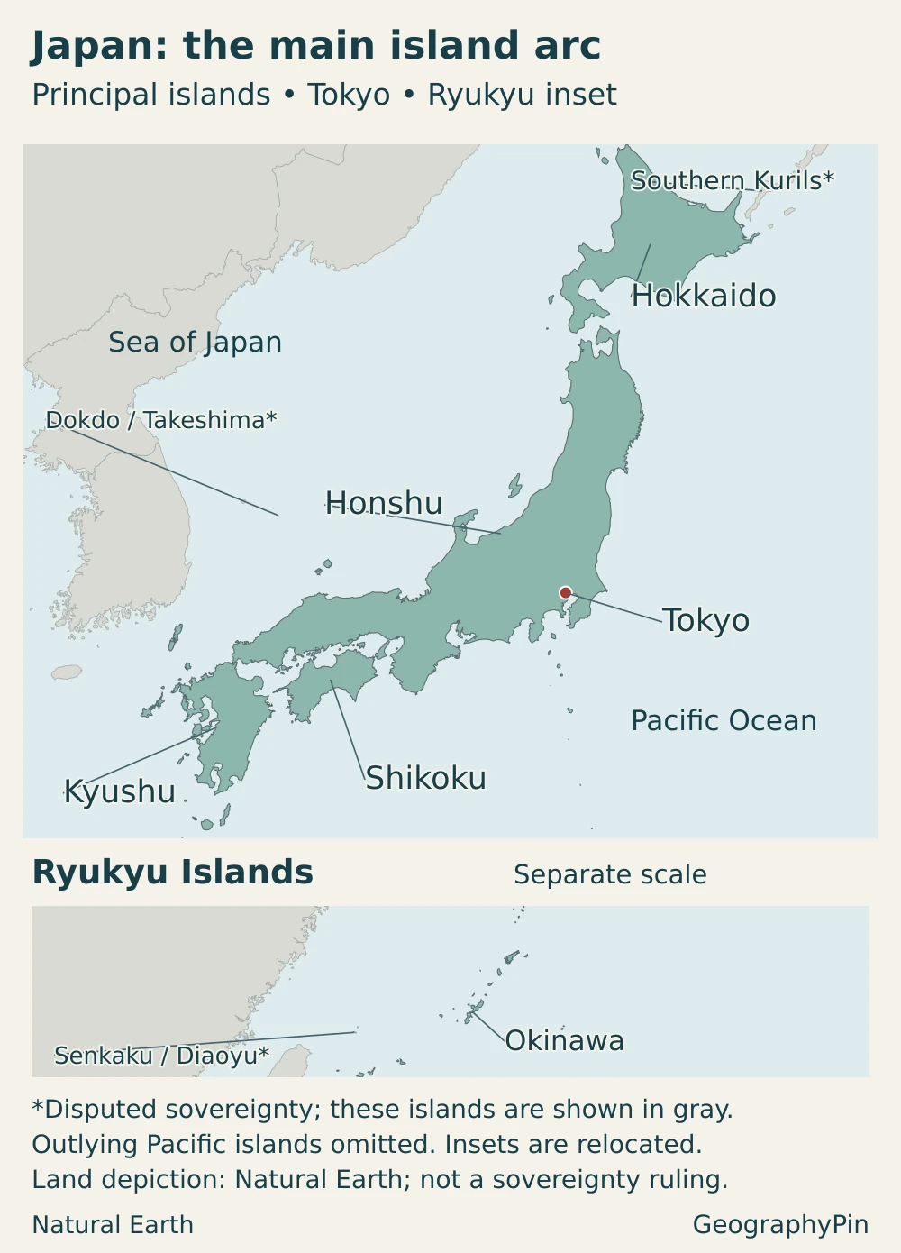
Territorial context: The southern Kurils, known in Japan as the Northern Territories, are administered by Russia and claimed by Japan. Dokdo/Takeshima is administered by South Korea and claimed by Japan. The Senkaku/Diaoyu Islands are administered by Japan and also claimed by China and Taiwan. Map symbols distinguish these disputes rather than treating a national claim as an agreed boundary.
Island geography matters at more than one scale: Japan is separated from the mainland by seas, but its own islands are also separated by straits and channels. A national map is therefore useful for understanding relative positions, while local maps are needed to distinguish an individual bay, city or island group.
2. Country facts and what the figures cover
| Item | Figure or description |
|---|---|
| Capital | Tokyo |
| Population | 122.69 million, provisional estimate for October 1, 2026 |
| Reported national area | About 145,936 square miles (377,973.68 km²), GSI measurement for July 1, 2026; includes rivers and lakes and follows Japan’s territorial accounting |
| Main islands | Hokkaido, Honshu, Shikoku and Kyushu |
| Administrative divisions | 47 prefectures |
| Language | Japanese, the de facto national language |
| Currency | Japanese yen (JPY) |
| Government | Parliamentary system under a constitution; the emperor is the symbol of the state, while the Cabinet exercises executive power |
| Highest mountain | Mount Fuji, about 12,388 feet (3,776 m) |
Area is not the same as dry land or administered territory
The area above is the Geospatial Information Authority of Japan’s reported national figure. Its method measures territory within the coastline and administrative boundaries, treating rivers and lakes as part of that area. It is not a dry-land-only measurement with inland water removed.
Territorial accounting also matters. Japanese official area statistics include claimed territories that are not administered by Japan. Consequently, the reported national total should not be mistaken for the area under Japanese administration, or combined uncritically with a population count to calculate density. A map’s treatment of disputed islands must be read separately from the statistical total.
The population estimate is dated independently of the area measurement. October 2026 is a provisional monthly estimate, not the final result of a census conducted that month. Keeping both dates visible is more useful than presenting an undated “current population.”
3. Mountains, coastal plains and an active island arc
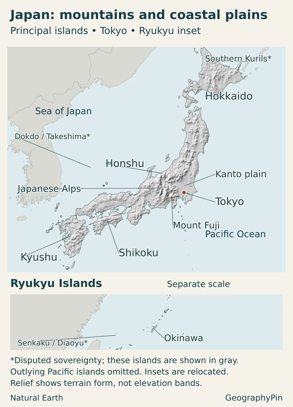
Mountains and hills occupy roughly three-quarters of Japan’s territory. That does not mean three-quarters is completely uninhabitable: valleys, basins and mountain towns form part of the settled landscape. It does mean that broad, continuous lowlands are much less extensive than a national outline alone might suggest.
| Area | Physical setting | What the contrast helps explain |
|---|---|---|
| Hokkaido | Northern island with mountains and lowlands in a colder climate | Extensive crop farming and dairying alongside a long snowy season |
| Honshu | Mountain backbones and lowlands including the Kanto plain | Large urban concentrations on plains, separated by substantial upland terrain |
| Shikoku and Kyushu | Southwestern main islands with mountainous interiors and coastal lowlands | Contrasts between inland relief and coastal settlement space |
| Ryukyu Islands | A chain southwest of the main islands, extending into subtropical latitudes | Island separation and a climate distinct from northern Japan |
Why coastal plains carry so much of the country’s activity
Relatively level land provides room for buildings, farms, roads and railways without the engineering demands of steep slopes. River mouths and adjoining bays also bring water routes and coastal access into the same places. These advantages help explain why large concentrations of people developed on plains around Tokyo and the major urban regions of central and western Honshu.
Mountains do not determine every location or economic outcome. Historical institutions, investment and transport networks have reinforced the importance of particular lowlands. The geographic point is that a large national population occupies an uneven landscape, not that every part of Japan is densely built up.
An island arc, not one continuous volcano
Japan’s geology reflects a long history of subduction along the northwestern Pacific margin. Where oceanic plates descend beneath adjoining plates, deformation, magma formation and the accumulation of material have helped build the island arcs. The Pacific and Philippine Sea plates are important parts of this setting, but the tectonic relationships are more complicated than a single plate boundary drawn through every island.
Mount Fuji is a conspicuous volcanic mountain, not a model for every Japanese peak. Mountain building also involves faulting, folding and uplift. A relief map shows the shape of the land; it does not identify every active fault, volcano or local hazard.
4. Climate, rivers and regional contrasts
Latitude and seasonal winds create different climates
Japan stretches from the cold conditions of Hokkaido to the subtropical islands of Okinawa and Amami. Elevation introduces further contrasts within individual islands, so one national description of the weather is necessarily incomplete.
Winter northwesterly winds bring cold air across the Sea of Japan. Moisture picked up along the way contributes to heavy snow on the Sea of Japan side, especially where air rises over mountains. The Pacific side is often sunnier and drier under the same winter pattern.
In early summer, the Baiu rain front brings a wet season to much of Japan. Later summer can be hot under the North Pacific high-pressure system; typhoons and autumn rain fronts add other episodes of substantial rainfall. These are broad seasonal patterns, not a forecast for every destination or every year.
Short, steep rivers connect mountains to plains
Many Japanese rivers descend steeply from mountain catchments toward the sea. They transport sediment that helps build lowland landscapes, while heavy rain can move rapidly through their catchments. Flood management therefore connects upstream slopes, river channels and downstream settlements rather than involving only the point where a river reaches a city.
The Shinano River provides a concrete example. Japan’s longest river runs about 228 miles (367 km), linking mountain and basin landscapes inland with the Echigo plain downstream. Sediment carried by the river helped build that lowland. The connection between mountain erosion and flat land near the coast is therefore visible in a real river system, not just a national generalization.
Flooding, landslides, earthquakes and volcanic activity are different hazards with different geographic controls. Earthquake shaking varies with the event, distance and local ground conditions. Tsunamis require a mechanism that displaces water; not every earthquake produces one. National-scale maps cannot replace local hazard maps or current official warnings.
5. Population, Tokyo and the geography of settlement
Japan’s provisional population estimate for October 2026 was lower than a year earlier. A national decline, however, does not describe every city or district in the same way. For understanding settlement, the location and definition of an urban area matter alongside the national total.
Tokyo is not a single interchangeable population boundary
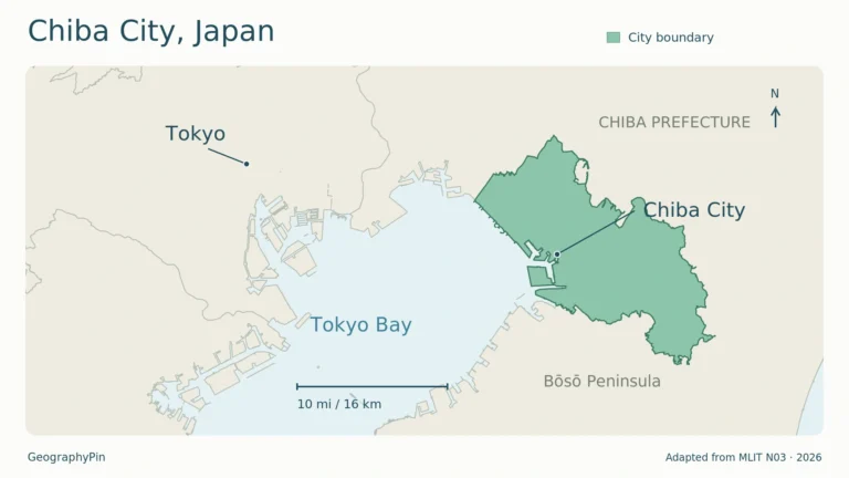
Tokyo is the capital, but “Tokyo” can describe different geographic units. Tokyo Metropolis includes the 23 special wards, the Tama area to their west and island municipalities in the Izu and Ogasawara groups. The wider metropolitan region extends beyond that administrative boundary into neighboring prefectures.
A population for the 23 wards cannot therefore be substituted for the population of Tokyo Metropolis, and neither automatically means the whole metropolitan region. This is why apparently conflicting Tokyo population figures may measure different places rather than contain an arithmetic error. Our Tokyo geography article examines the city’s setting more closely.
Japanese and the distinction between practice and law
Japanese is the country’s predominant language and functions as its national language. Japan does not have a general statutory provision simply declaring Japanese the national or official language; particular legal settings, such as court proceedings, have their own language requirements. “De facto national language” is therefore a clearer short description than an unsupported claim about a single blanket language law.
6. Government and the geography of the economy
National government and prefectures
Japan’s constitution places legislative authority in the National Diet, which consists of two houses. Executive authority belongs to the Cabinet, headed by a prime minister designated by the Diet. The emperor’s constitutional position is symbolic rather than one of governing power.
The 47 prefectures divide the country administratively; they are not 47 separate islands. An island may contain many prefectures, and a prefecture may include offshore islands. Keeping the physical map and the administrative map distinct helps prevent confusion when comparing regional statistics.
Manufacturing hubs and agricultural regions
Aichi, around Nagoya in central Honshu, illustrates how industry and transport combine. Its manufacturing economy sits within a major metropolitan region connected by expressways, Shinkansen rail services, airports and the ports of Nagoya and Mikawa. Access to both inland markets and overseas shipping gives its location a significance that a simple mountain-versus-plain contrast cannot fully explain.
Hokkaido offers a different example. Despite its cold climate and long snowy season, it supports substantial crop farming and dairying. Wheat, potatoes, sugar beet and raw milk are among its important products. Larger-scale agricultural land use there contrasts with the densely urbanized parts of Honshu, showing why Japan should not be imagined as one uniform industrial cityscape.
These examples connect economy to location without reducing it to physical geography alone. Terrain, climate and coastal access shape opportunities, while technology, infrastructure and human decisions influence how those opportunities are used.
Frequently Asked Questions
Does Japan have only four islands?
No. Four islands dominate most overview maps, but GSI’s count published in 2023 identified 14,125 islands under a specified mapping method, generally counting naturally formed islands with a perimeter of at least 328 feet (100 m), with additional legally designated islands. The increase over an older count mainly reflected improved mapping and counting methods, not thousands of islands suddenly appearing.
Is Japan made entirely of volcanic rock?
No. Volcanic rocks are important, but Japan also contains sedimentary rocks, metamorphic rocks and rocks formed from magma that cooled underground. Its geological history includes material added at subduction margins as well as volcanism, deformation and uplift.
What Did We Learn Today?
Japan’s geographic contrasts become clearer when its islands, mountains and lowlands are considered together. Plains concentrate many cities and connections, but regional climates and land uses differ markedly. Dated statistics, clearly defined urban boundaries and transparent map coverage help explain the country more accurately than a single population figure or a simplified island outline.
Sources & Data Notes
Population: October 1, 2026 provisional estimate, released October 20. Area: July 1, 2026 GSI measurement, including rivers and lakes and following Japan’s territorial accounting, not an area limited to territory it administers. Square-mile and foot equivalents are rounded conversions. Population density is not calculated from these differently scoped figures. Island counts depend on the mapping rules and date.
- MLIT: Shinano River basin and Echigo plain
- Statistics Bureau: census territorial coverage and area conventions
- Japan Ministry of Foreign Affairs: territorial positions
- South Korea Ministry of Foreign Affairs: Dokdo position
- Taiwan Ministry of Foreign Affairs: Diaoyutai position
- China Ministry of Foreign Affairs: Diaoyu position
- Statistics Bureau: October 2026 population estimate
- GSI: July 2026 area report
- GSI: area measurement conventions
- Statistics Bureau: Statistical Handbook of Japan 2026, geography and administrative divisions
- GSI: 2023 island count and methodology
- GSI: Mount Fuji elevation
- Geological Survey of Japan: geology of Japan
- JMA: Japan’s seasonal climate
- JMA: earthquakes and shaking intensity
- NOAA: how earthquakes generate tsunamis
- MLIT: terrain, rivers and settlement patterns (qualitative geography only)
- Tokyo Metropolitan Government: geography and administrative scope
- House of Councillors Legislative Bureau: Japanese language and law
- House of Representatives: Constitution of Japan
- Aichi Prefecture: regional industry and transport
- Hokkaido Prefecture: agriculture, Data Book 2026
- Bank of Japan: currency and banknotes
Maps and illustration: Original GeographyPin cartography uses public-domain Natural Earth country outlines, populated places and shaded relief. The main map and relocated Ryukyu inset use separate Lambert azimuthal equal-area projections and different scales; distances cannot be compared across the panels. Shading represents terrain form, not measured elevation bands. Regional labels locate broad areas rather than mapped boundaries. The GSI Map of Japan was consulted for locations, not copied or adopted as a neutral ruling on territorial claims. Mount Fuji’s position follows JMA’s volcano information.
Territorial context is stated as of November 2026. Natural Earth’s de facto boundary convention forms the geographic base; disputed island groups receive separate labels. Neutral gray on the locator indicates contested sovereignty, not necessarily administration by a different state. On the physical map, grayscale also represents relief, so the asterisks identify disputes. Outlying Pacific islands are omitted. These overview maps are not a complete territorial inventory or a depiction of the exact area in GSI’s reported national total. The featured illustration uses a decorative Hinomaru flag motif over the principal islands, with a separate-scale Ryukyu inset.