Lake Lugano is a branching lake shared by Switzerland and Italy, not simply the water in front of Lugano’s city center. Its deep northern basin, narrow connections and intricate border make it a particularly useful place to separate physical geography from political geography.
Lake Lugano, also called Ceresio, straddles Ticino in Switzerland and Lombardy in Italy. It has three connected basins with a combined reference area of 18.9 square miles (48.9 square kilometers). Its northern basin reaches 945 feet (288 meters), while the Tresa River carries its outflow toward Lake Maggiore.
How to use this article: Compare the three basins, locate their narrow connections, understand Campione’s border, and follow the water downstream.
1. Where Is Lake Lugano?
Lake Lugano lies across the border between Switzerland’s canton of Ticino and Italy’s Lombardy region. Its alternative name, Ceresio, appears frequently in Italian-language environmental reports and local place descriptions. Both names refer to the same lake.
Lugano city is not the whole lake
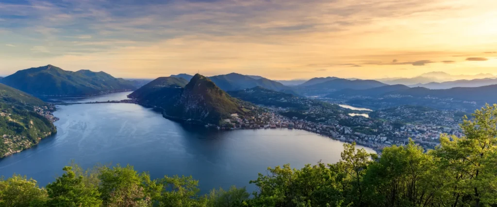
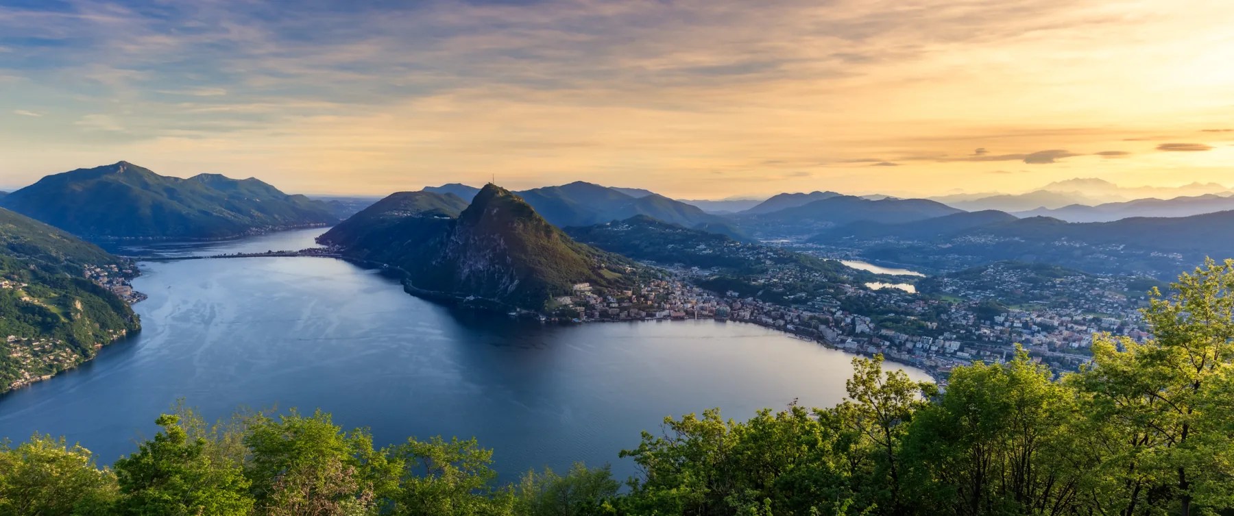
Lugano is a Swiss city on the lake, but the water extends far beyond its waterfront. Its arms reach toward Porlezza, Capolago, Agno and Ponte Tresa. A photograph taken in the city therefore shows only one part of a branching international waterbody.
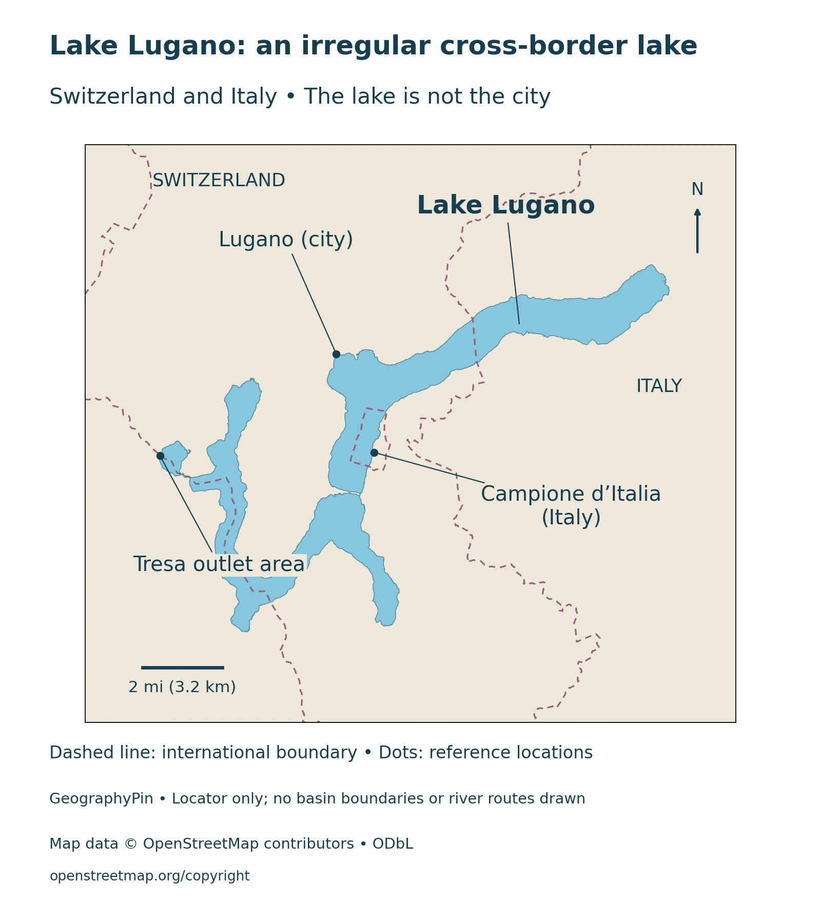
The lake does not form a simple straight division between two countries. Swiss and Italian territory meet it in several places, and the shoreline bends around peninsulas and steep hills. Following a lake arm and following the national boundary are two different exercises.
2. Three Connected Basins, Very Different Depths
Lake scientists distinguish a northern basin, a southern basin and the small Ponte Tresa basin near the outlet. Together, the areas in CIPAIS’s 2021 monitoring report total about 18.9 square miles (48.9 square kilometers). The deepest reference value belongs to the northern basin, not to every arm of the lake.
Reading the three-basin reference table
| Basin | Surface area | Maximum depth |
|---|---|---|
| North | 10.6 sq mi (27.5 km²) | 945 ft (288 m) |
| South | 7.8 sq mi (20.3 km²) | 312 ft (95 m) |
| Ponte Tresa | 0.4 sq mi (1.1 km²) | 164 ft (50 m) |
The report concerns the 2021 monitoring campaign and a multiyear synthesis; these reference dimensions are not presented as a new bathymetric survey in that year. Ponte Tresa is separate in this table, whereas some summaries group it with the southern basin.
A maximum depth is a deepest-point measurement, not a typical depth along the shore. The wide difference between basins also explains why one lakewide depth figure is an incomplete description of Lugano’s underwater landscape.
3. Melide, Lavena and the Shape of the Lake
CIPAIS describes a valley inherited from river erosion and subsequently reshaped by glaciers. The resulting lake occupies connected depressions rather than one regular bowl. Its branching surface is a clue to that landscape history, although a shoreline map alone cannot reveal the shape of the lake floor.
A causeway and a narrow passage
The Melide causeway marks the division between the north and south basins. It was built over a pre-existing submerged moraine, so the underwater constriction was not created simply by laying a road across open water. The lake’s glacial setting and later engineering both matter to understanding this crossing.
Ticino’s water authority describes the north basin as extending from Porlezza toward Melide–Bissone and the south basin from Capolago toward Agno. Farther west, the Strait of Lavena connects the southern basin with the smaller Ponte Tresa basin.
These are physical subdivisions of one connected lake. Their divisions do not follow the Swiss–Italian border: an underwater constriction and a national boundary describe different features. For wider context, see our explanation of lakes and their basins.
4. Campione d’Italia and the International Shoreline
Campione d’Italia is an Italian exclave on Lake Lugano, surrounded by Swiss territory. Its municipality belongs to the province of Como even though it is detached from the main body of Italian territory.
Why a border cannot be inferred from the water’s edge
The municipal description includes both land and lake water within Campione’s territory. The water’s edge is therefore not automatically the edge of the municipality or country. National territory extends across parts of the lake as well as the surrounding land.
It is useful to separate three things when reading the map: the shoreline, the international boundary and the locations of settlements. A settlement point identifies a place; it does not describe its entire municipal area. Likewise, an international boundary is not a boat route, fence or visible line across the water.
This geographical complexity is part of the lake’s character. For current entry requirements and travel documents, consult official border guidance for the journey you intend to make.
5. The Tresa Outlet and Lake Maggiore
Water leaves Lake Lugano through the Tresa River at the Ponte Tresa end of the system. The municipality of Lavena Ponte Tresa identifies the Tresa as the lake’s sole river outlet and states that its water reaches Lake Maggiore.
One lake draining toward another
This makes Lugano part of a connected drainage landscape rather than an isolated mountain basin. Lake Maggiore and Lake Lugano remain distinct lakes even though water travels from one to the other. A river connection does not merge their names, shorelines or environmental measurements.
Several tributaries also enter Lugano. CIPAIS monitors rivers including the Cassarate, Vedeggio, Cuccio and Magliasina, alongside the outlet, to understand what water carries into and out of the lake. Those measurements concern more than the movement of water: they also help assess nutrient inputs and the lake’s response.
6. Water Quality and Reading a Lake View
A clear-looking surface and a healthy deep-water environment are not interchangeable descriptions. Lake monitoring examines different depths and locations, while bathing advice concerns particular places and conditions. Neither should be reduced to a single judgment based on a scenic photograph.
Long-term improvement is not a daily bathing report
Ticino’s account of the long-term monitoring record describes declining phosphorus concentrations but continuing problems such as algal blooms, incomplete winter mixing and low oxygen near the bottom. The numerical examples on that page refer to 2019, not to a measurement made today.
The basin differences help explain why scientists do not rely on one shoreline sample to characterize the whole lake. Deep water can behave differently from surface water, and the northern and southern basins do not necessarily mix in the same way.
For a visit, identify the actual destination and consult current local notices, weather and transport information. A lakewide map does not establish a continuous walking route around every arm, and a historic photograph does not confirm today’s visibility or water conditions. This distinction lets the geography remain useful without turning a reference article into an unreliable live service report.
What Did We Learn Today?
Lake Lugano’s three connected basins differ greatly in depth. Their physical divisions do not follow the international border, and Campione d’Italia adds a separate enclave to the political map. The Tresa drains the lake toward Maggiore, while environmental monitoring distinguishes basins, depths and dates rather than treating the entire lake as one uniform sample.
Sources & Data Notes
The table uses the separate north, south and Ponte Tresa basin references in the CIPAIS report published in 2022 about the 2021 campaign. Publication year is not claimed as a new depth survey. U.S. units are rounded conversions. Other summaries aggregate Ponte Tresa with the southern basin and publish differing volume or mean-depth series; those are not mixed here. The environmental discussion describes dated monitoring context, not current bathing conditions.
The locator uses actual OpenStreetMap lake and national-boundary geometry, including the Campione enclosure. It is geographical context, not a legal survey or navigation chart. Reference markers and label leaders are not routes. The photograph is an authored, processed panorama from 2016, not a current condition report; its precise viewpoint is not identified here.
- CIPAIS: location, basin formation and the Melide constriction
- DACD-SUPSI, 2022: CIPAIS 2021 campaign report, Table 1.1 and tributary monitoring
- Canton Ticino: basin connections and dated water-quality context
- Campione d’Italia municipality: territorial geography
- Lavena Ponte Tresa municipality: the Tresa outlet and Lake Maggiore