A map of Windermere can be surprisingly easy to misread: the name appears on both the water and an inland town. Separating those places is the first step toward understanding the lake’s long glacial basin, its two deeper sections and the river that drains it toward the sea.
Windermere is a freshwater lake in England’s Lake District, about 10.5 miles (17 kilometers) long. Its glacial basin contains connected northern and southern sections, with the River Leven draining the southern end. Windermere town stands inland to the east; Bowness-on-Windermere is on the shore.
How to use this article: Match the settlement names to the map, interpret the lake’s depth figures, or follow the route of water to the sea.
1. Where Is Windermere?
Windermere is a freshwater lake in the southern part of England’s Lake District National Park, in Cumbria. Its long, narrow shape extends broadly north to south between wooded shores and rising hills. The name also belongs to a nearby town, but the town is not on the lakeshore.
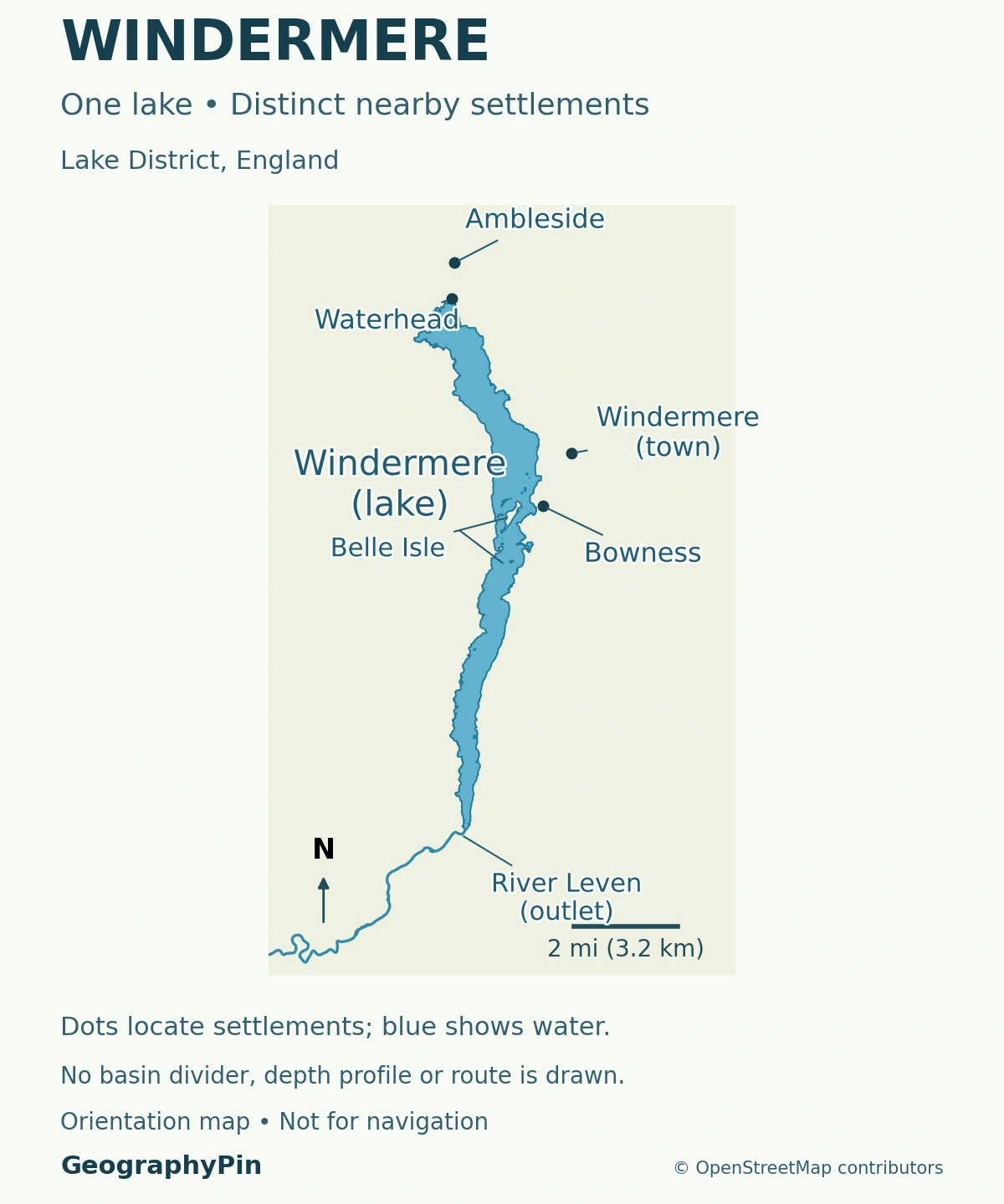
The distinction matters on a map and when planning a journey. A train ticket to Windermere takes you to the inland settlement. A lakeside address at Bowness or Waterhead identifies a different destination. The surrounding Lake District contains many other separate lakes, including nearby Esthwaite Water and Coniston Water.
The lake, the town and the shore have different names
| Map name | What it identifies |
|---|---|
| Windermere, the lake | The long body of water. |
| Windermere, the town | An inland settlement east of the lake, with the railway terminus. |
| Bowness-on-Windermere | A settlement on the eastern shore, downhill from Windermere town. |
| Ambleside | A settlement inland from the lake’s northern end. |
| Waterhead | The lakeside area south of central Ambleside, at the head of the lake. |
2. How Big and Deep Is the Lake?
The national park authority gives Windermere’s length as about 10.5 miles (17 kilometers). UKCEH identifies it as England’s largest natural lake by surface area. That is an England-wide distinction, not a claim that its surface area exceeds every lake in Britain or the United Kingdom.
The area and depth values below come from Table 1 of UKCEH’s Lakes Tour 2021 report, published in 2023. The report treats the northern and southern basins separately. They remain connected parts of one lake, not two lakes divided by land.
| Measurement | North basin | South basin |
|---|---|---|
| Surface area | About 3.1 square miles (8.1 square kilometers) | About 2.6 square miles (6.7 square kilometers) |
| Maximum depth | About 210 feet (64 meters) | About 138 feet (42 meters) |
| Mean depth | About 82 feet (25.1 meters) | About 55 feet (16.8 meters) |
The combined surface area is about 5.7 square miles (14.8 square kilometers). The table lists the lake surface at about 128 feet (39 meters) above sea level. This elevation is a reference characteristic, not a live lake-level reading.
A maximum depth describes one part of the basin
The lake’s overall maximum depth is the deeper northern figure, not the sum of the two basin maxima. Likewise, averaging 210 and 138 feet (64 and 42 meters) would not give the mean depth of the whole lake. Maximum depth, mean depth and surface area describe different aspects of the basin.
None of these figures establishes the depth at a particular pier or beach. For the underlying distinction between a basin, its water and its drainage, see what makes a lake a lake.
3. How Ice Shaped Windermere
Windermere occupies a glacially shaped valley. Its elongated basin belongs to a landscape repeatedly modified by ice, rather than a volcanic crater or an artificial reservoir behind a modern dam.
Ice deepened an inherited valley
The British Geological Survey describes Lake District glaciers widening, straightening and deepening pre-existing river valleys. Moving ice carries rock fragments that abrade the ground, while plucking removes blocks from the underlying rock. These processes help explain how a valley can become broad and deep enough to contain a long lake.
That explanation does not mean one glacier carved every feature in a single episode. Later glaciation removed much older evidence, and the landscape continued to change after the ice retreated. Streams, sediment deposition and slope processes have all contributed to the present setting.
The term glacial lake describes the origin of the basin. Windermere is not fed by an active glacier today. Rainfall and water flowing through the surrounding drainage network sustain the modern lake.
4. Two Basins and a Southern Outlet
A shallow underwater sill separates the deeper north basin from the shallower south basin. The Changing Windermere report, published by the Love Windermere partnership in March 2025, locates this sill around the ferry crossing just south of Belle Isle. It is an underwater threshold, not a land barrier across the lake.
Follow the water from the fells to Morecambe Bay
The northern basin receives water from the Rothay and Brathay river systems, among other inflows. Those systems connect Windermere with upland valleys and lakes to the north. Cunsey Beck brings water from Esthwaite Water into the southern basin, which also receives water from the north basin.
At the southern end, the River Leven carries water out of Windermere through Newby Bridge and onward past Backbarrow and Haverthwaite. It reaches the estuary near Greenodd, where the River Crake from Coniston Water joins the drainage system, before the water reaches Morecambe Bay.
Windermere is therefore an open-drainage lake with a surface outlet. A shoreline map identifies the waterbody; a catchment map would answer the different question of which surrounding land drains toward it. Neither is interchangeable with a map of the national park.
The two-basin distinction is also useful scientifically. The deeper northern basin and shallower southern basin need not respond identically to environmental pressures. Separate measurements help researchers understand differences that a single whole-lake label could conceal.
5. Why Towns and Transport Developed Around the Lake
Bowness and Windermere town have different settlement histories as well as different positions. Cumbria County History Trust describes Bowness as an older church village. Windermere town developed around the railway terminus at Birthwaite after the railway arrived in 1847. The modern shared name can obscure that difference.
The railway did not need to run along the water’s edge for the lake to shape the town’s development. Visitors arriving inland could continue toward the shore, while businesses and accommodation developed around the transport connection. Lake scenery, settlement and access became closely linked.
The lake’s north–south form also creates a practical contrast between traveling along a shore and crossing the water. The council-operated Windermere Ferry connects Ferry Nab on the Bowness side with Far Sawrey on the western side, carrying pedestrians, cycles and vehicles. It is a cross-lake connection, not another name for all passenger-boat services on Windermere.
Check the council’s current ferry information before relying on that crossing. Weather, maintenance or service interruptions can change the available journey; a line on a map does not guarantee that a boat is running.
6. Reading Access and Water Information
Choose the actual destination before choosing a route. The national park’s Windermere and Ambleside guide distinguishes the inland towns from shore locations. An address containing “Windermere” alone may not identify the waterfront you expect.
Similarly, a lake outline does not show public access to every piece of shoreline. Use current access guidance and local notices rather than assuming that an uninterrupted lakeside walking route exists everywhere.
An ecological assessment is not today’s swimming advice
Windermere has a long history of scientific study. UKCEH describes regular visits to its north and south basins alongside higher-frequency automatic measurements. These observations help track conditions and change, but they are not equivalent to a same-day test at every swimming spot.
A Freshwater Biological Association expert note explains that nutrient enrichment, climate change and food-web changes can interact in the lake. Reducing that history to one pollutant or a single cause misses important parts of the system. Equally, a historical study should not be presented as proof that the whole lake is safe or unsafe today.
For a water activity, check current weather, relevant site notices and the Environment Agency’s bathing-water information for the named location. Water-quality information and physical safety are separate issues. A depth table or a favorable photograph cannot assess either for an individual outing.
What Did We Learn Today?
Windermere is both a lake name and a town name, but the town is inland. Bowness and Waterhead identify shore locations. Glaciation shaped the long basin, an underwater sill separates its connected northern and southern sections, and the River Leven drains the lake toward Morecambe Bay. Basin measurements, settlement names and current water conditions answer different questions and should not be confused.
Sources & Data Notes
The basin table uses the reference characteristics in UKCEH’s 2023 report, not a new depth survey. Conversions are rounded. The national park’s approximate whole-lake length is reported separately rather than calculated by joining basin measurements. The 2025 partnership report supports the sill’s general location and drainage explanation. No current bathing-water classification or live water-level reading is claimed.
- Lake District National Park: length and area reference figures
- Lake District National Park: Windermere, Bowness, Ambleside and Waterhead
- UKCEH: Lakes Tour 2021, published 2023, Table 1
- UKCEH Environmental Change Network: Windermere
- Love Windermere: Changing Windermere, March 2025
- British Geological Survey: Ambleside district, glacial history
- Royal Geographical Society: how glaciers shape the land
- South Cumbria Rivers Trust: Windermere and the Leven
- Cumbria County History Trust: Windermere and Bowness
- UKCEH: monitoring the Cumbrian lakes
- Freshwater Biological Association: Windermere expert information note, 2022
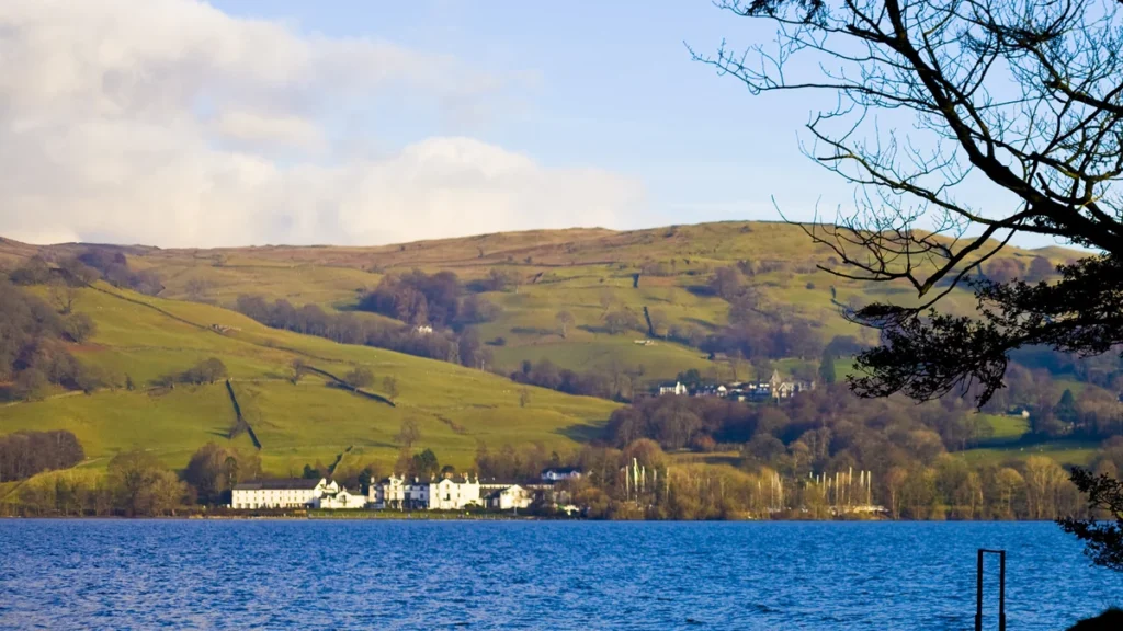
Featured photograph: “Lake Windermere, Lake District National Park” by Mike Norton (miketnorton), CC BY 2.0. Cropped, resized and converted to WebP. The photograph shows a real view of Windermere, not the entire lake or a mapped basin division.
Map methods: The locator uses OpenStreetMap’s actual lake outline with mapped islands, representative settlement points and River Leven geometry. Belle Isle remains land within the waterbody outline. British National Grid projection and equal axis scaling preserve geographic relationships; the metric scale label is rounded. No underwater sill line, basin boundary, bathymetry, ownership boundary or navigational route is inferred. The river continues beyond the map’s southern edge.