From Tarn Hows, Black Crag offers a different way to understand the southern Lake District: a climb above the wooded water into a wider landscape of separate lakes and distant fells. Before following a route, make sure you have the right Black Crag and the right starting point.
Black Crag is the summit of Black Fell, north of Tarn Hows in England’s Lake District. It overlooks a landscape of lakes and higher fells between the Coniston and Hawkshead areas. The climb extends beyond the tarn’s lakeside paths and should not be confused with Black Crag in Borrowdale.
How to use this article: Locate the correct summit, interpret the wider view, or compare the different walking approaches before opening the land manager’s route instructions.
1. Which Black Crag Is This?
Black Fell, not the Borrowdale climbing crag
This Black Crag is the summit of Black Fell, north of Tarn Hows in the southern part of the national park. It belongs to the landscape between Coniston and Hawkshead, not to the climbing crag of the same name in Borrowdale. Searching only “Black Crag” can therefore lead to the wrong place.
The distinction matters before you choose a map, photograph or starting point. Borrowdale climbing information describes another location. Here, the useful geographic pairing is Black Fell and Tarn Hows. The Striding Edge fell archive records the summit around British National Grid reference NY340016.
The broader Lake District geography guide puts this small fell within the region’s wider pattern of lakes and uplands. Black Crag is not one of the highest mountain summits, but its position between different lake basins makes it a revealing viewpoint.
2. Read the Landscape Beyond the Summit
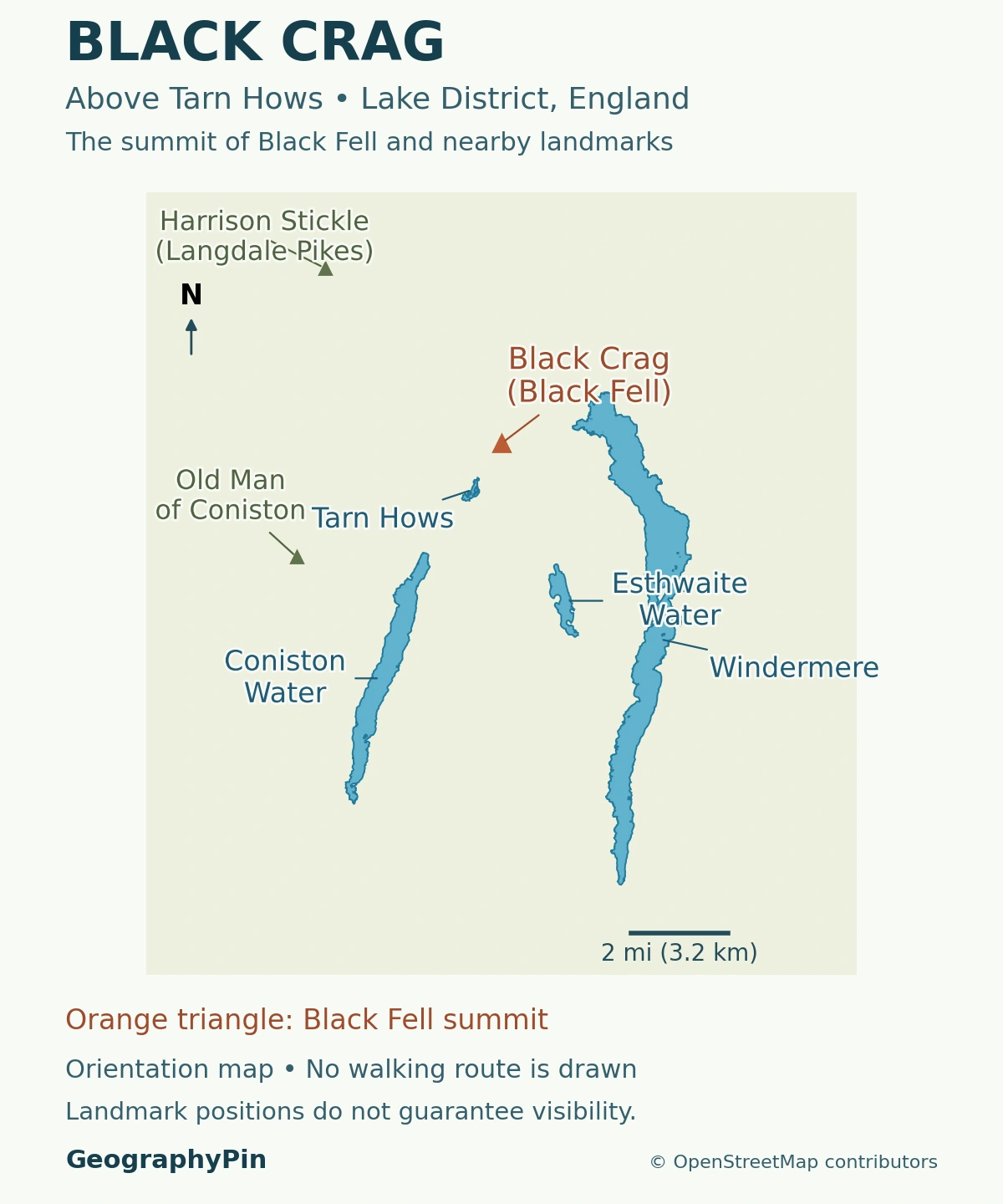
The National Trust identifies views toward the Old Man of Coniston and the Langdale Pikes, together with Windermere, Esthwaite Water, Coniston Water and Tarn Hows. These names form a useful landscape key, not a promise that every feature will be visible in every photograph or in poor weather.
Lakes nearby, higher fells beyond
Tarn Hows anchors the immediate setting. Farther away, the larger lakes occupy separate parts of the district. They are not different bays of one continuous body of water, even when a distant view compresses the intervening land.
A locator map and a panorama answer different questions. The map shows where named places lie relative to the summit; the panorama shows what the terrain and visibility allow you to see from one position. A name beside a map symbol should not be read as a label on an unidentified distant ridge.
Start by finding Tarn Hows on the map, then compare its position with the more distant lakes. This makes the view easier to interpret than treating the horizon as a list of peaks to tick off. Cloud, vegetation, the viewing direction and your exact position around the summit all affect what is visible.
3. Three Walks That Should Not Be Confused
The summit extension starts at Tarn Hows
The National Trust’s online Black Crag itinerary starts at the main Tarn Hows car park. It is rated moderate, with a full distance of 4.2 miles (6.72 kilometers) and an estimated 2 hours 30 minutes. The summit extension returns along its outward approach before the itinerary completes the tarn circuit. It is not a separate circular route around the summit.
Its approach passes Iron Keld and includes gates, narrow fell paths, boggy ground and a steeper final climb. The lakeside surface does not describe the entire outing. Use the National Trust’s detailed route for current instructions rather than navigating from this overview.
| Walk | Main purpose | Important distinction |
|---|---|---|
| Black Crag extension | Climb from the tarn area to the fell summit | Includes rougher and steeper ground beyond the lakeside circuit |
| Tarn Hows circuit | Follow the path around the water | Does not itself reach Black Crag |
| Tom Gill approach | Ascend through woodland from Glen Mary | Different starting point and more demanding terrain |
4. A Lakeside Path Is Not an Accessible Summit Route
The park authority includes Tarn Hows in its Miles Without Stiles information, but grades the route “for some,” not as universally accessible. Its description notes rough sections and gradients reaching 1:5. Read the detailed access information against your own needs rather than interpreting the route’s inclusion as a guarantee.
More importantly, that assessment concerns the tarn route. It does not extend automatically to the fell climb. The fact that two walks share their first stretch says little about the surface, gradient or obstacles farther on.
Glen Mary is a different approach
The National Trust describes the Tom Gill walk from Glen Mary Bridge car park as challenging. It climbs through woodland beside the stream and includes scrambling sections that become especially difficult when wet. The description specifically rules it out for visitors with limited mobility.
Do not substitute Glen Mary for the main Tarn Hows starting point and keep the Black Crag itinerary’s quoted distance or time unchanged. Likewise, adding the published lengths of different circular walks can double-count shared stretches. Decide on the complete route first, then assess its distance and terrain.
5. Volcanic Rock Beneath a Lake District View
The fell sits within a region whose rocks preserve an ancient volcanic history. The British Geological Survey describes the Lincomb Tarns Tuff Formation as part of the Borrowdale Volcanic Group, including welded ignimbrite and lapilli tuff. These are volcanic rocks formed from fragmented material, not sediment deposited by the present-day tarn.
The National Trust points out an exposure of this formation on its Black Crag approach. That is a specific observation along the walk, not a reason to assign every rock in the panorama to the same unit.
“Welded” describes hot volcanic fragments becoming compacted and joined after deposition. The texture records how the rock formed; the present hills, paths and water margins describe a much later landscape. Separating those two timescales helps explain why a quiet wooded tarn can sit among rocks with a volcanic origin.
6. Use the Viewpoint Guide Alongside Current Route Advice
A clear day can make the summit feel close to the car park, but visibility is not a measure of route difficulty. The Lake District National Park’s walking guidance emphasizes checking weather, allowing enough daylight and choosing a walk suited to the group. Carry a usable map and know how to follow it rather than relying on a scenic image.
Check the land manager’s information before setting out. Parking arrangements, paths and local conditions can change; an evergreen landscape article cannot verify them for the day of your visit. Keep enough time for the return as well as the climb.
The most useful question is not simply “Can I get to Black Crag?” It is whether you have selected the correct Black Crag, the intended starting point and a complete route appropriate to your group. Those distinctions make this small fell much easier to understand.
What Did We Learn Today?
Black Crag above Tarn Hows is the summit of Black Fell, not the Borrowdale climbing venue. The viewpoint connects nearby water with a wider landscape of separate lakes and fells. A tarn circuit, the summit extension and the Tom Gill approach are different walks, and lakeside accessibility does not imply an accessible fell route.
Sources & Data Notes
Route distance and estimated time refer to the National Trust’s online Black Crag itinerary from the main Tarn Hows car park. They are not measurements for every approach. The summit location is distinguished from other places called Black Crag. Walking conditions and visibility vary; follow the official route and access information.
- National Trust: Black Crag route and named views
- National Trust: separate Tarn Hows circuit
- National Trust: Tom Gill approach and terrain
- Lake District National Park: Tarn Hows access assessment
- Striding Edge: firsthand Black Fell location and summit archive
- Keswick Mountain Rescue: record identifying the separate Borrowdale climbing venue
- British Geological Survey: Lincomb Tarns Tuff Formation
- Lake District National Park: walking preparation
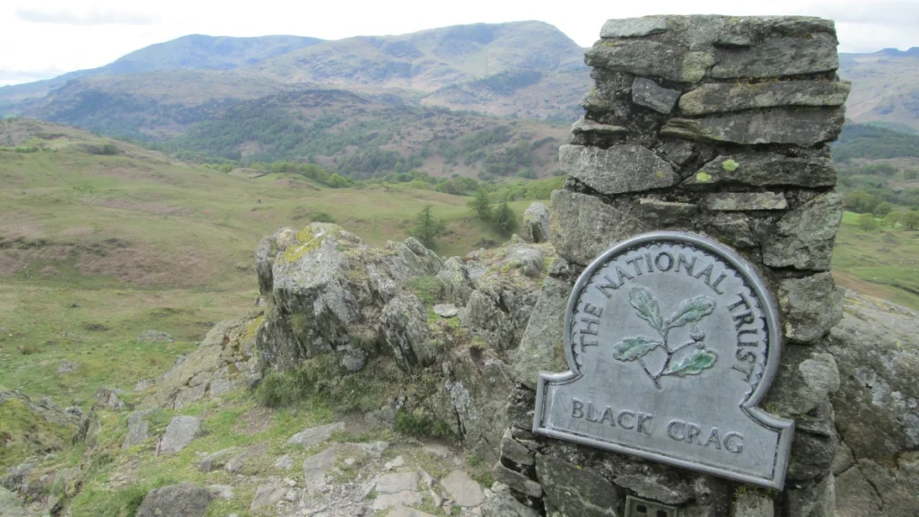
Featured photograph: “Black Crag summit view – towards the Coniston fells”, © Peter S / Geograph, CC BY-SA 2.0. Cropped, resized and converted to WebP; the adapted photograph remains under that license. This is a real summit photograph, not a generated landscape. Individual distant peaks have not been labeled.
Map methods: OpenStreetMap peak points and complete lake polygons are projected in British National Grid, with equal horizontal and vertical scale. The map preserves the lakes’ islands and locates the summit rather than substituting a similarly named crag. Landmark markers are geographic positions, not measured sightlines. No walking path, ownership boundary or terrain model is shown. The scale is rounded in the label. Neither a National Trust route illustration nor an Ordnance Survey basemap has been copied.