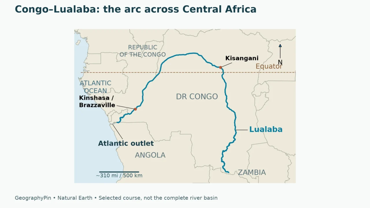
The Congo River flows through Central Africa to the Atlantic Ocean. Its upper course is called the Lualaba; farther downstream it passes Kisangani, curves across the equator and reaches Kinshasa and Brazzaville. The river’s channel, its farthest headwaters and the much wider Congo Basin are related but different geographic features.
Follow the river’s three reaches, compare its remote headwaters, and locate the two capitals.
1. Congo River map: follow the great arc
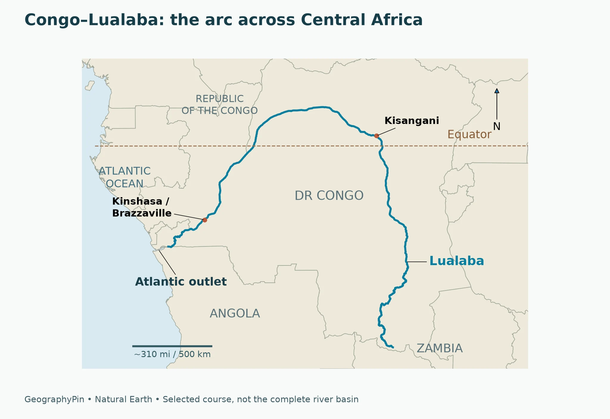
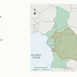
The Congo is easiest to understand as a connected sequence rather than a line running straight across Africa. From the upper Lualaba in the southern Democratic Republic of the Congo, the mapped course runs north toward Kisangani. Beyond that city, it sweeps northwest and then southwest before turning toward the Atlantic coast.
The equator helps make this shape memorable. The selected Congo–Lualaba course crosses from the Southern Hemisphere into the Northern Hemisphere, then returns south on its western side. That large arc is why a map centered only on the river mouth misses so much of the river’s geography.
Read the course in three parts
CICOS, the International Commission of the Congo–Oubangui–Sangha Basin, describes an upper Lualaba, a middle Congo and a lower Congo. These are useful geographic divisions, not three independent rivers.
| Reach | Geographic guide | What changes |
|---|---|---|
| Upper Lualaba | Southern DR Congo toward Kisangani | The upper main course runs generally north through the interior. |
| Middle Congo | Kisangani to Pool Malebo | The river makes its broad equatorial arc and receives major tributaries. |
| Lower Congo | Below Pool Malebo toward the Atlantic | The river crosses a gorge-and-rapids landscape before entering its estuary. |
The map emphasizes that sequence. It does not outline the drainage basin, plot every tributary or identify every headwater channel. Its coastal detail is generalized: the selected river line stops within the lower estuarine area rather than tracing every channel to the open ocean.
2. Where does the Congo River start?
Two different questions often hide inside the word “source.” One asks where the recognized upper main course begins. The other asks which connected headstream lies farthest upstream along the river system. Those questions can produce different names without either map necessarily being wrong.
Lualaba: the upper main course
CICOS identifies the upper course in southern Katanga as the Lualaba and describes the Congo name downstream of Kisangani. On a map organized around that convention, the Lualaba is the natural starting point for tracing the main river northward.
Kisangani is therefore an important reference point, not simply another city along the route. It helps readers connect maps labeled “Lualaba” in the southeast with maps labeled “Congo” farther downstream. The change in name does not mean that the watercourse starts again there.
Chambeshi: the remote headwater convention
Zambia’s Water Resources Management Authority describes the Chambeshi as the Congo’s most remote headstream by length. It rises in the Mbala highlands near Lake Tanganyika and flows southwest toward the Bangweulu wetlands. This is a headwaters-of-the-system definition, not a claim that the river called Congo runs directly across northern Zambia under that name.
The map follows the Congo–Lualaba course; the Chambeshi belongs to the wider headwater network.
Why river-length figures need a definition
A total length depends on the upstream endpoint chosen, the connected channel followed and the mapping scale used to measure bends. A figure quoted for the full headwater system should not be silently presented as the length of the shorter line visible on a main-course map.
For that reason, this profile does not calculate a total from the simplified map or combine a source location from one convention with a length from another. The distinction is more useful than an apparently precise number with an unclear starting point. Our guide to what a river is explains the broader relationship between a main channel and its tributaries.
3. Which countries does the Congo River touch?
The Democratic Republic of the Congo is central to the main course: the Lualaba and much of the Congo run through it. Farther west, part of the river separates the Democratic Republic of the Congo from the Republic of the Congo. Near the Atlantic estuary, Angola also borders the river, with Soyo on its southern side opposite DR Congo.
That is different from asking which countries contribute water to the Congo Basin. A drainage basin includes land whose streams eventually feed the river, even where the main river itself never passes. Zambia’s Chambeshi headwaters illustrate the difference particularly well.
| Geographic question | What to look for | Common mistake |
|---|---|---|
| Where does the main course run? | The river channel through DR Congo and its international boundary reaches | Treating every basin country as a main-channel country |
| Where do the farthest headwaters begin? | The connected upstream river network, including the Chambeshi convention | Assuming every upstream channel has the same river name |
| What is the Congo Basin? | The wider land area drained by the Congo and its tributaries | Confusing a drainage region with a single country |
| What are the two Congos? | Two separate states on a political map | Treating their shared name as one government or territory |
Table downloads (2)
- Three geographic reaches of the Congo–Lualaba course (4 × 3)View tableDownload CSV
- Main channel, headwaters, basin and countries: different questions (5 × 3)View tableDownload CSV
Kinshasa and Brazzaville face one another
Kinshasa, the capital of the Democratic Republic of the Congo, and Brazzaville, the capital of the Republic of the Congo, stand on opposite sides of the river in the Pool Malebo area. NASA’s geographic description places Brazzaville north of the river and Kinshasa south of it.
The pairing is a useful anchor when reading the western part of the map. The river connects the two urban settings geographically while also forming an international boundary. The combined map label locates the two-capital reach at continental scale; it is not a street map or a representation of the cities as one settlement.
For the political and historical distinction, see why there are two Congos. This river profile focuses on the watercourse rather than repeating that country-by-country explanation.
4. Why the basin matters as much as the main river
A river’s visible channel is only one part of its geography. The Congo receives water from tributaries that drain a much larger area, bringing together landscapes north and south of the equator. CICOS identifies the Oubangui, Sangha and Kwa-Kasai among the major tributary connections of the middle river.
On an overview map, the strongest visual feature is the arc of the main channel. Hydrologically, however, tributaries and wetlands help explain what moves through that channel. A map with only one blue line should not be read as evidence that the surrounding country has no other rivers.
An equatorial basin does not have one uniform season
CICOS explains that contributions from different parts of the basin help moderate the Congo’s seasonal flow variation. Because the basin extends across the equator, its northern and southern catchments do not all follow the same seasonal rainfall pattern. Wetlands also influence how water moves through the system.
This does not mean that the river has a constant discharge, that floods cannot occur or that every tributary behaves alike. It means that the downstream river integrates contributions from a large and varied network. Conditions at one town cannot describe the whole basin at the same moment.
River basin and rainforest are not interchangeable outlines
The phrase “Congo Basin” is also widely associated with Central Africa’s forests. In a drainage context, though, the defining relationship is where water flows, not where a particular vegetation type begins or ends. A forest map and a hydrological basin map answer different questions.
The country lines provide political orientation, while the river line shows the selected course. Neither is a boundary of the rainforest or the drainage basin.
5. From Pool Malebo to the Atlantic
Pool Malebo is a broad river setting around the two capitals, but the lower Congo is not simply a continuation of a flat, open-water reach. CICOS describes the river crossing the Crystal Mountains through gorges, cascades and rapids between the Kinshasa area and Matadi.
That contrast explains why the appearance of a wide river on a regional map can be misleading. Width alone does not tell a reader about gradient, current, submerged obstacles or continuity of navigation. The lower-river landscape is a major geographic break between the interior waterways and the Atlantic outlet.
Estuary, mouth and ocean
Toward Boma and the coast, the river enters an estuarine setting and reaches the Atlantic near Banana. On the opposite side of the lower estuary lies the Angolan area around Soyo. These coastal references help distinguish the mouth from the inland capitals, which are not ocean ports simply because they stand on the same river.
An estuary describes the river’s coastal transition, not just a single dot marking where a blue line meets a shoreline.
Frequently Asked Questions
Which ocean does the Congo River flow into?
The Congo reaches the Atlantic Ocean on the west coast of Central Africa, near Banana in DR Congo and the Angolan estuary area around Soyo.
Are the Congo and Lualaba different rivers?
Lualaba is the name used for the upper main course. CICOS describes the Congo name downstream of Kisangani, so the names refer to connected reaches of the same major river system.
Does the Congo River start in Zambia?
Zambia’s Chambeshi is described by WARMA as the most remote headstream by length. That is a wider river-system definition; the upper main course called Lualaba is in DR Congo.
Which two capitals are on the Congo River?
Kinshasa and Brazzaville face one another in the Pool Malebo area. They are the capitals of the Democratic Republic of the Congo and the Republic of the Congo respectively.
Is the Congo Basin the same as DR Congo?
No. DR Congo is a country. The Congo Basin is a drainage area extending beyond national borders, including land whose tributaries feed the river.
What Did We Learn Today?
The Congo–Lualaba course makes a great arc across Central Africa before reaching the Atlantic. The Lualaba main-course convention and the Chambeshi remote-headwater convention answer different source questions. Kinshasa and Brazzaville face each other along the river, while the wider basin crosses more borders than the main channel. The lower river crosses gorges and rapids before widening into its Atlantic estuary.
Sources & Data Notes
Source terminology distinguishes the upper Lualaba from the remote Chambeshi headwaters. No total river length, depth ranking or basin-country count is inferred from the map. Original GeographyPin maps use generalized public-domain Natural Earth data and are not navigation charts.
- CICOS: upper, middle and lower Congo course
- CICOS: Congo Basin overview
- CICOS: basin seasonality and flow
- Zambia WARMA: Chambeshi catchment and remote headstream
- NASA Earth Observatory: Kinshasa and Brazzaville
- United Nations Africa Renewal: Soyo on the Congo estuary
- Natural Earth: public-domain cartographic data