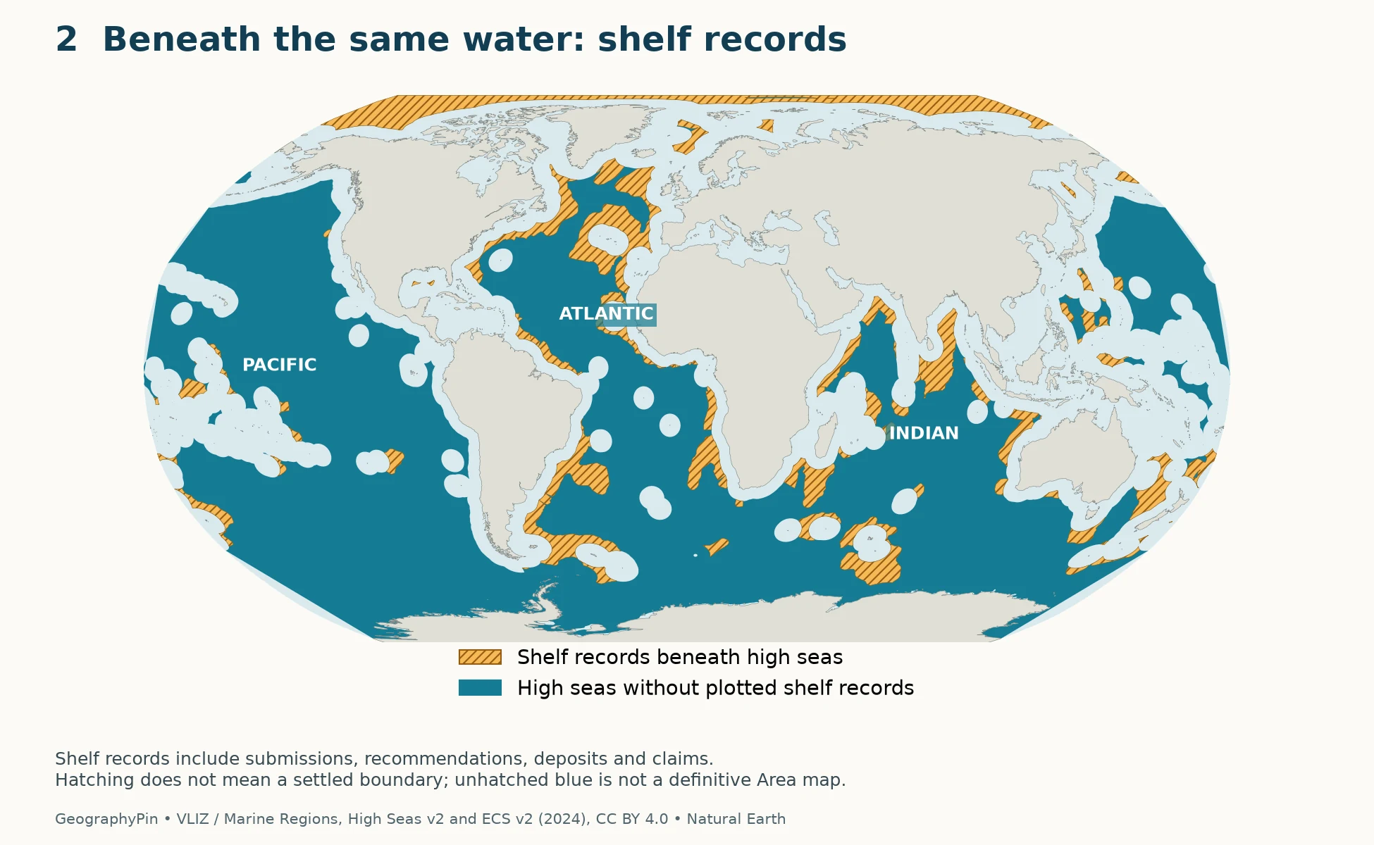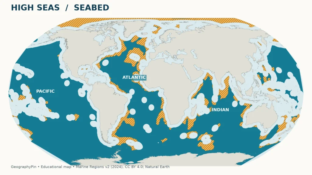
A map of the High Seas Treaty needs more than one shade of blue. The water above a location and the seabed below it can fall under different legal regimes, even far from land.
The High Seas Treaty applies to marine biodiversity in areas beyond national jurisdiction: the high seas and the international seabed Area. These are not identical footprints. High-seas water can lie above a coastal state’s continental shelf, so a water-column map alone cannot show the full geographic distinction.
How to use this article: Start with the map key, compare water and seabed at one location, or check the treaty’s implementation timeline.
1. Where the high seas are

Read the colors before the boundaries
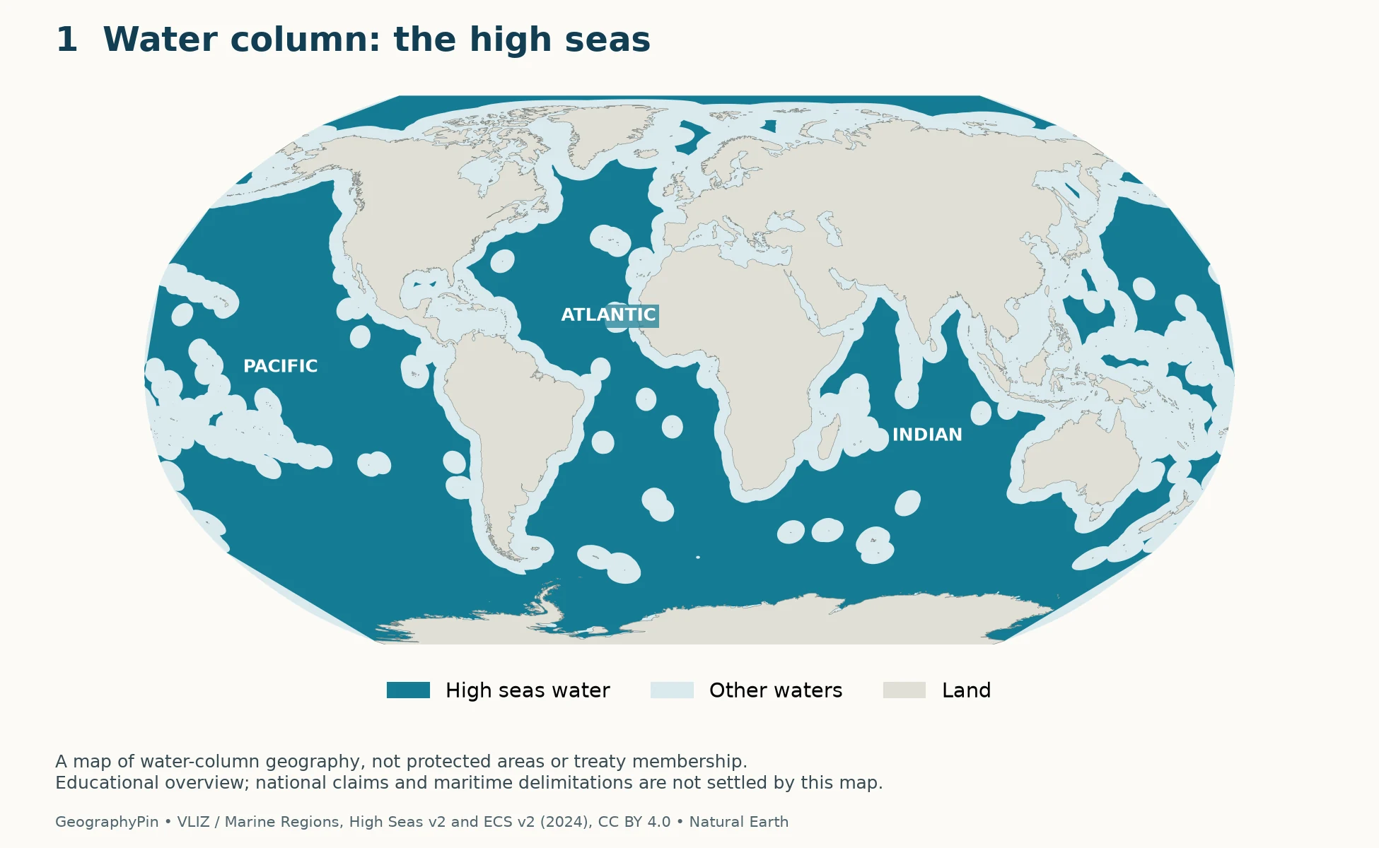
Teal is the high seas. Pale blue represents other waters; gray is land. The high seas exclude exclusive economic zones, territorial seas, internal waters and the archipelagic waters of archipelagic states. Their extent is therefore not a simple circle drawn around each continent.
Islands, archipelagos and facing coastlines affect the pattern. An island far from a continental mainland can have maritime zones of its own. Conversely, a space enclosed by surrounding maritime zones may still be high seas. At world-map scale, small features and narrow gaps are difficult to distinguish: use the source data for detailed research rather than reading a legal boundary from a colored pixel.
The map’s large open-ocean areas help explain the treaty’s global significance, but geographic coverage and legal participation are different questions. A country’s ratification is not represented by painting the ocean beside it. The agreement addresses areas beyond national jurisdiction, while its obligations apply through its provisions and the states and organizations that are parties.
For the names and geographic arrangement of the ocean basins themselves, use the oceans of the world map. An ocean-basin boundary and a maritime-jurisdiction boundary answer different questions.
2. Why the seabed map is different

The international seabed Area means the seabed, ocean floor and subsoil beyond national jurisdiction. It is not simply another name for the water above that seabed. The BBNJ Agreement’s definition of areas beyond national jurisdiction includes both the high seas and the Area.
A coastal state’s legal continental shelf may extend beyond 200 nautical miles where the applicable requirements are met. Rights over that shelf do not turn the water above it into an exclusive economic zone. This is the central reason that the two maps should not be collapsed into one “international waters” outline.
Follow one vertical line from the surface down
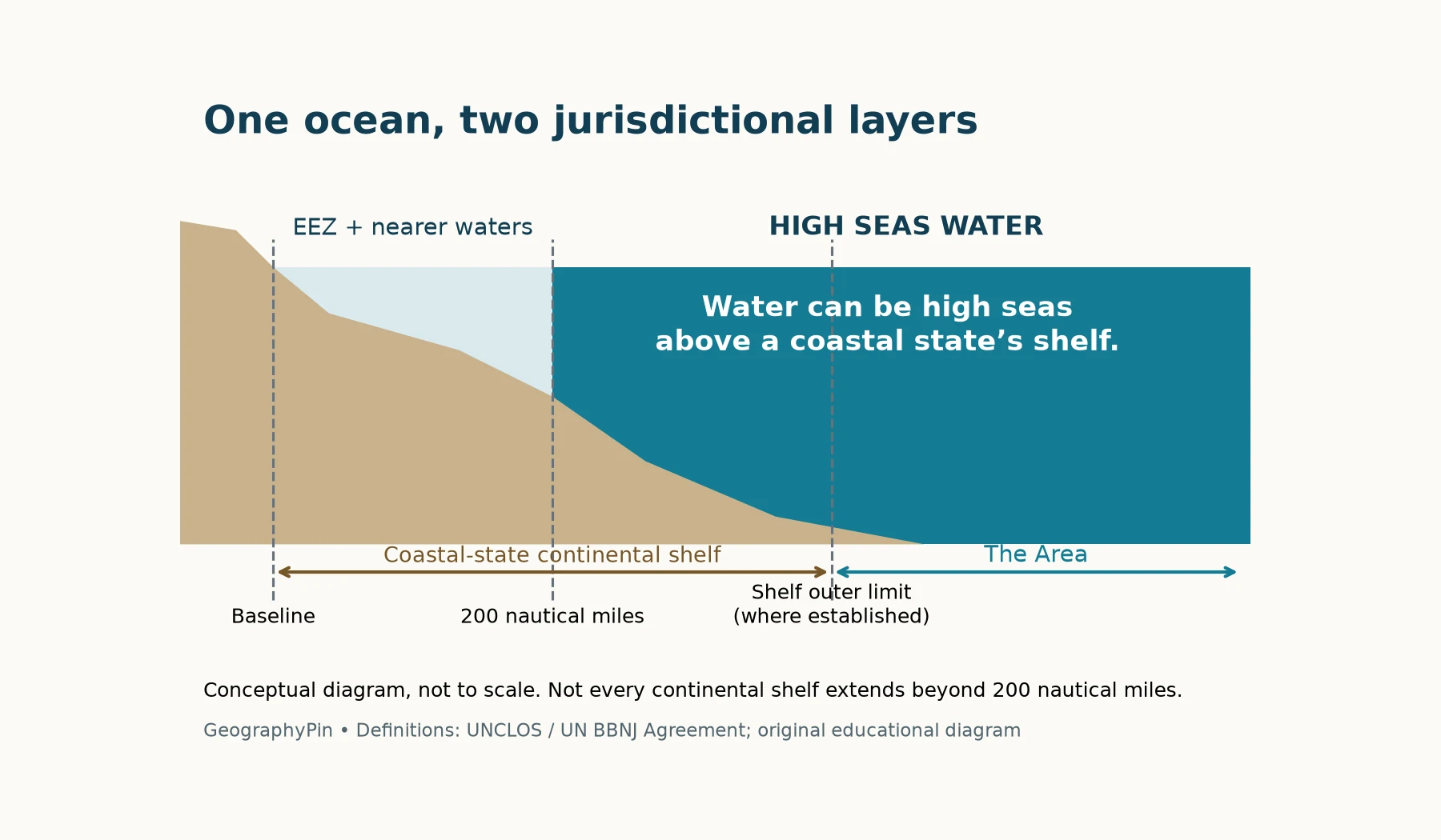
Imagine a location beyond a coastal state’s exclusive economic zone but above its continental shelf. At the surface, the location can be high seas. At the bottom, coastal-state shelf rights can still apply. Farther offshore, beyond the limits of national seabed jurisdiction, the bottom is the Area.
That distinction matters for biological resources as well as for a classroom map. It prevents a reader from assuming that everything below high-seas water is automatically international seabed. It also prevents a map of seabed claims from being mistaken for an expansion of national control over the entire water column.
The gold overlay is deliberately cautious. Marine Regions combines records with different statuses, including overlapping claims. Displaying them together is useful for explaining where the vertical distinction can arise; it does not validate each claim or resolve a maritime dispute.
3. The maritime zones, compared
Distances in maritime law are measured from legally defined baselines, not simply from a convenient beach or a mainland shoreline. Nautical miles are the operative unit. For scale, 12 nautical miles are about 13.8 ordinary miles (22.2 kilometers), and 200 nautical miles are about 230 ordinary miles (370 kilometers).
| Term | What it describes | Key distinction |
|---|---|---|
| Internal and archipelagic waters | Waters defined under the relevant baseline and archipelagic rules | Not high seas |
| Territorial sea | A belt extending up to 12 nautical miles from baselines | Coastal-state sovereignty, subject to applicable passage rights |
| Exclusive economic zone | A zone extending up to 200 nautical miles from baselines | Specified sovereign rights and jurisdiction, not the same regime as the territorial sea |
| High seas | Waters outside the excluded national maritime zones | A water-column category |
| Continental shelf | Seabed and subsoil within the coastal state’s legal shelf entitlement | Can extend beyond the EEZ; does not change the status of overlying water |
| The Area | Seabed, ocean floor and subsoil beyond national jurisdiction | Not identical to the high-seas water footprint |
“Up to” matters. Where coasts face one another or entitlements overlap, a state cannot assume an unobstructed 200-nautical-mile strip in every direction. Delimitation and the relevant legal circumstances affect the boundaries.
“Continental shelf” also has a physical-geography meaning: the comparatively shallow submerged continental margin before the steeper slope. That physical feature and the legal continental shelf are not interchangeable. A depth contour alone cannot establish the legal shelf boundary.
The common phrase “international waters” is less precise than these categories. It is sometimes used broadly for waters outside a territorial sea, which may still lie inside an EEZ. When interpreting a High Seas Treaty map, ask which legal definition the map actually uses.
4. What the treaty changes
The formal name is the Agreement under the United Nations Convention on the Law of the Sea on the Conservation and Sustainable Use of Marine Biological Diversity of Areas beyond National Jurisdiction, commonly shortened to the BBNJ Agreement or High Seas Treaty.
Its four principal subjects are marine genetic resources and benefit-sharing; area-based management tools, including marine protected areas; environmental impact assessments; and capacity-building and marine technology transfer. These are mechanisms for conservation and sustainable use, not a redraw of the world’s ocean basins.
The treaty does not automatically make all high seas a protected area. It creates a process for proposing and establishing area-based measures, with consultation and scientific and technical consideration. A map of geographic scope should therefore remain separate from any map of protected areas actually established.
It also does not replace every existing ocean institution. The agreement is designed to work with relevant legal instruments and global, regional and sectoral bodies rather than undermine them. Fisheries management, shipping and seabed activities already have distinct international arrangements; “beyond national jurisdiction” does not mean “outside all law.”
The implementation timeline
- June 19, 2023: the BBNJ Agreement was adopted.
- January 17, 2026: it entered into force.
- January 11–22, 2027: the UN has scheduled the first Conference of the Parties at its New York headquarters.
These dates come from the UN’s BBNJ portal and conference background page. The January meeting is a forthcoming implementation event, not evidence that new protected areas have already been designated. Country participation and later decisions should be checked against the UN’s official records rather than inferred from this geographic overview.
5. How to interpret these maps
Both world maps use the same extent and projection so that readers can compare the same locations. The first draws the Marine Regions high-seas layer. The second adds the portions of its extended-continental-shelf records that intersect that layer. The gold pattern is an overlay of records, not an independently adjudicated boundary.
The underlying products are High Seas v2 and Extended Continental Shelves v2, both dated 2024. They were retrieved for this article in November 2026. A retrieval date is not a claim that all boundaries reflect developments through that date. Product-specific version records, rather than the date of retrieval, identify the map data edition.
The pale coastal-water background is a visual complement to the high-seas layer, not a country-by-country allocation of sovereignty. No country colors are used. This avoids suggesting that a general-purpose dataset settles contested entitlements or that an EEZ is sovereign territory in the same sense as land.
Marine Regions licenses these data under CC BY 4.0 and describes them as scientific, educational and research products, not legal or navigational determinations. GeographyPin’s changes are the projection, styling, labels and high-seas/shelf overlay. Land outlines are from public-domain Natural Earth data.
Use the maps to understand the distinction between water and seabed. For a particular claim, permit, activity or boundary dispute, consult the underlying official documents and appropriate legal expertise. A world overview cannot resolve those questions, and the absence of gold hatching is not proof that a particular seabed location has no outstanding claim.
Frequently Asked Questions
Does “high seas” mean the water is unusually deep?
No. It is a legal category, not a depth measurement. Ocean depth, distance from a mainland and water-column jurisdiction are separate properties.
Is this a map of countries that ratified the treaty?
No. It shows ocean geography and seabed-record overlaps. Ratification is a separate, changing list maintained by the UN Treaty Collection.
Can I use the colors to decide whether an activity is allowed?
No. The map is educational. An activity’s legal position depends on the relevant location, jurisdiction, rules and obligations; being outside an EEZ is not a general permission.
What Did We Learn Today?
Ocean jurisdiction has a vertical dimension. The high seas describe water, while the Area describes seabed beyond national jurisdiction; coastal-state continental shelves can separate their footprints. The BBNJ Agreement adds conservation mechanisms for biodiversity beyond national jurisdiction, but its geographic scope is neither a blanket protected-area designation nor a substitute for resolving maritime boundaries.
Sources & Data Notes
Treaty dates were verified against the UN’s November 2026 information. Maps use Marine Regions High Seas v2 and Extended Continental Shelves v2 (2024), with shelf records clipped to the high-seas footprint, plus Natural Earth land outlines. Boundaries and claims retain the source’s educational limitations. GeographyPin created the map design and conceptual diagram; no map establishes legal limits or predicts conference decisions.
- United Nations: BBNJ Agreement and first Conference of the Parties background.
- United Nations: BBNJ Agreement overview factsheet.
- NOAA: Maritime Zones and Boundaries.
- U.S. Senate Treaty Document 118-2: transmittal and explanation of the BBNJ Agreement (2024; used for the agreement’s mechanisms, not current U.S. participation).
- Flanders Marine Institute (2024): High Seas, version 2; Extended Continental Shelves, version 2. Product citations, methodology and license and limitations.
- Natural Earth: public-domain map data.