“River in the sky” is a memorable phrase, but it can suggest the wrong picture: a suspended stream of liquid water. The real feature is moving moisture, and what happens when that moisture reaches land depends on more than its nickname.
An atmospheric river is a long, narrow, temporary corridor of strong water-vapor transport in the atmosphere. Winds carry the moisture, often within a larger weather system. When the air is lifted, it can produce rain or snow. Some events support water supplies; others contribute to severe flooding.
Start here: Understand what moves, follow the landfall diagram, then separate water supply from flood risk.
1. What is actually flowing?
Water vapor, not a liquid stream
An atmospheric river is a moving pattern in the atmosphere, not a channel carved into the sky. The American Meteorological Society defines it by strong horizontal transport of water vapor along a long, narrow, temporary corridor. That transport is concentrated in the lower atmosphere and is often associated with winds ahead of a cold front in a midlatitude storm system.
The moisture need not all originate in the tropics. The AMS definition explicitly allows tropical and extratropical sources. Calling every atmospheric river a direct pipeline from the equator would therefore be misleading. Its position and shape evolve with the weather; it does not occupy a permanent course like a mapped river valley.
Water vapor is water in its gaseous state. It is different from the liquid droplets and ice crystals that make clouds visible. A cloud band may accompany the system, but the term identifies moisture transport rather than a particular cloud shape. Our water-cycle explanation separates those changes of state from the movement of water between places.
2. How can that moisture become rain or snow?
Lifting connects transport to precipitation
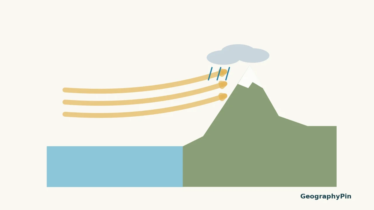
Transport supplies moisture; lifting helps turn that supply into precipitation. When moist air rises, it cools and can reach saturation. Cloud particles then need to grow before precipitation falls. Reaching a coastline is not, by itself, a switch that makes all the transported vapor fall out.
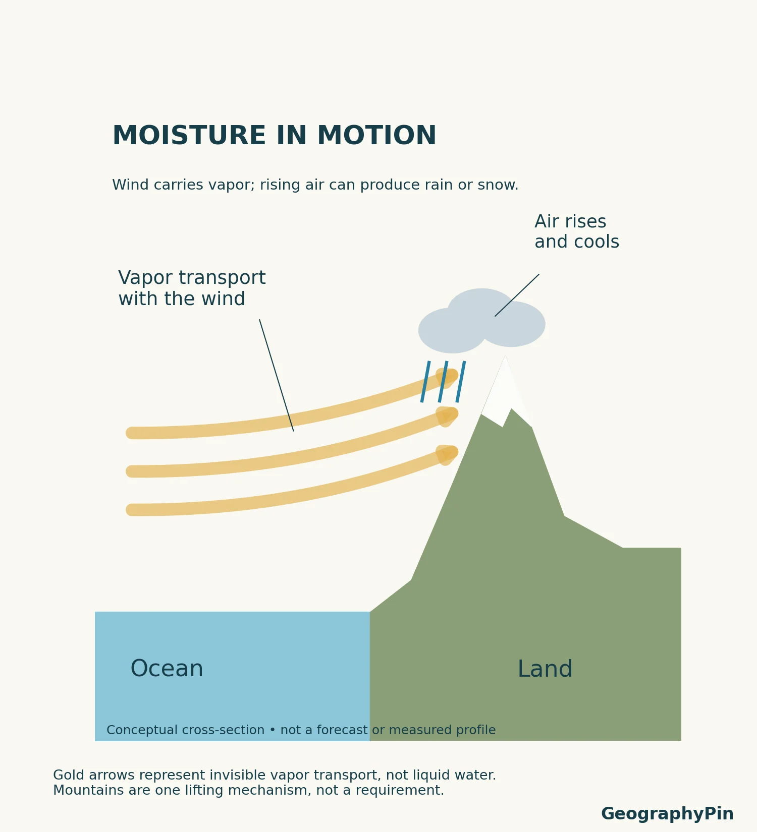
Mountains can force incoming air upward and concentrate precipitation on exposed slopes. The temperature conditions determine whether precipitation reaches a place as rain or snow. Different elevations within the same storm can therefore experience different conditions. The diagram deliberately contains no snowfall boundary or rainfall total.
Our rain-shadow guide examines the separate question of a persistent wet–dry contrast across mountains. An atmospheric river describes a transient moisture-transport feature; a rain shadow describes a geographic precipitation pattern. They can interact without being the same phenomenon.
3. Why some events help and others cause damage
Useful water and hazardous impacts
Atmospheric rivers are part of the water supply as well as a flood hazard. NOAA emphasizes that many provide beneficial rain or snow. Water stored as mountain snow can contribute to later runoff; rainfall can replenish surface-water supplies. The name alone does not mean a disaster is underway.
Risk increases when a strong moisture supply and persistent weather keep delivering precipitation to a vulnerable area. NOAA identifies large vapor amounts, strong winds and stalled systems as important ingredients in severe events. Duration matters alongside intensity: a place receiving repeated precipitation has a different exposure from one crossed briefly.
The ground matters too. USGS highlights the danger near recently burned slopes, where heavy rainfall can trigger damaging debris flows. The same broad weather label does not describe identical consequences in every watershed. Local conditions and the actual forecast are necessary to judge impacts.
A useful reading habit is to separate three questions: how much moisture is moving through the atmosphere, how much precipitation is expected at a location, and what that water will do on the ground. A map of the first is not automatically an answer to the other two.
4. Is the Pineapple Express the same thing?
The Pineapple Express is a familiar atmospheric-river pattern that can carry moisture from near Hawaii toward western North America. It is an example, not a second name for every atmospheric river. A system with a different moisture source or route should not automatically receive that label.
California receives much of the public attention, but atmospheric rivers are not confined to that state or even to the Pacific. USGS describes their importance in other parts of North America and in regions including western Europe, southern Chile and New Zealand. They belong to the global circulation of water, not one country’s weather vocabulary.
On the western U.S. coast, the connection with winter rain and mountain snow makes them particularly relevant to seasonal water management. That regional importance should not be turned into an unsupported claim that atmospheric rivers exist only in winter everywhere.
5. How to read an atmospheric-river forecast
First identify the product. An observed satellite image, a forecast moisture-transport map and a forecast precipitation map show different things. Check its valid time and legend before comparing two pictures. Bright colors have no universal meaning across different products.
Scientists combine observations from satellites, aircraft and instruments on land with numerical weather models. NOAA’s atmospheric-river portal emphasizes both intensity and duration. Those measurements and forecasts help water managers consider potential supply and flood impacts together.
Look for the local precipitation forecast and official warnings rather than treating an atmospheric-river headline as a property-level forecast. The educational illustration here gives no current arrival time, storm category or expected rainfall. It explains a process, not today’s conditions.
Frequently Asked Questions
Does an atmospheric river have to produce flooding?
No. A moisture corridor is not a flood diagnosis. Precipitation intensity and duration, along with the receiving landscape, determine the consequences. Many events provide useful water without major damage.
Can I identify one just by looking at clouds?
A cloud band alone does not establish the strength or structure of water-vapor transport. Meteorologists use observations and analyses of the atmospheric moisture and winds, not just the visual shape of a cloud.
What Did We Learn Today?
Follow the moisture, then ask what makes it rise and where precipitation falls. Atmospheric rivers move vapor rather than liquid streams; their effects range from valuable water supply to serious hazards. The Pineapple Express is one pattern within that broader phenomenon. A transport map, a precipitation forecast and a flood warning answer related but different questions.
Sources & Data Notes
Definitions and process explanations follow AMS, NOAA and USGS. The original GeographyPin images are conceptual illustrations, not satellite observations, measured profiles or forecast maps. Arrow widths do not encode moisture quantities; terrain and clouds have no geographic coordinates. No event-specific totals, universal detection threshold or current risk category is assigned.
- American Meteorological Society: Atmospheric river — technical definition, moisture sources and lifting.
- NOAA: What are atmospheric rivers? — beneficial and hazardous effects; Pineapple Express.
- NOAA Physical Sciences Laboratory: About ARs — monitoring, intensity and duration.
- NOAA NESDIS: What Is an Atmospheric River? — moisture movement, observations and West Coast seasonality.
- USGS: Rivers in the Sky — global occurrence, water resources and burned-slope hazards.