A map of Tanzania brings together several very different scenes: an inland capital, an Indian Ocean port, the islands of Zanzibar, Africa’s highest mountain and enormous lakes along the mainland’s western and northern edges. Understanding how these places fit together is more useful than treating the country as either a safari landscape or an island destination.
Tanzania is an East African country comprising a large mainland territory and Zanzibar, whose main islands are Unguja and Pemba. Dodoma is the capital; Dar es Salaam is a major coastal commercial center and port. The mainland combines a broad interior plateau, mountain blocks, Rift Valley landscapes and shared Great Lakes.
How to use this article: Compare the main landscapes, follow the shared Great Lakes, or understand Zanzibar’s place in the Union.
1. Locate mainland Tanzania and Zanzibar
Tanzania lies south of the equator in East Africa, with the Indian Ocean to the east. Its neighbors are Kenya, Uganda, Rwanda, Burundi, the Democratic Republic of the Congo, Zambia, Malawi and Mozambique. Some international boundaries cross lakes rather than dry land; the DRC faces Tanzania across Lake Tanganyika.
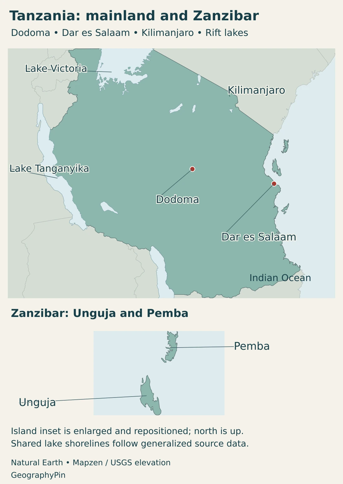
Zanzibar lies off the mainland coast. Unguja is often called “Zanzibar Island” in everyday and travel usage, but Zanzibar is not only Unguja: it also includes Pemba and smaller islands. The island name, the archipelago and Zanzibar’s governmental status refer to different things.
Dodoma is inland, in the central mainland. Dar es Salaam faces the ocean, while the northern and western lake regions connect Tanzania with inland neighbors. These positions create a country with both maritime connections and a large continental interior.
The map shows the country’s overall setting, not every small island, administrative boundary or local route. Lakes are shown as water bodies extending across borders, rather than as features wholly belonging to whichever country occupies the center of the map.
2. Country facts and Dodoma
| Item | Detail |
|---|---|
| Capital | Dodoma |
| Population | 70,038,850 in the NBS 2026 national projection, covering mainland Tanzania and Zanzibar. |
| Published total area | About 365,060 sq mi (945,500 km²), including inland water, in NBS Tanzania in Figures 2025. |
| State structure | United Republic comprising mainland Tanzania and Zanzibar, with distinct Union and Zanzibar responsibilities. |
| Official languages | Kiswahili and English, as listed in the national statistical booklet. |
| Currency | Tanzanian shilling |
| Major coastal commercial center | Dar es Salaam, distinct from the national capital. |
Population is a 2022 census-based projection, not a new census count. Area follows the rounded 2025 NBS national total, including water: about 884,000 km² of land and 61,500 km² of water. It is not a precise new boundary survey or mainland-only figure. Square miles are rounded.
Dodoma’s status as capital is established in the country’s capital-city legislation, which applies to both mainland Tanzania and Zanzibar. Dar es Salaam’s commercial importance does not make it a second legal national capital. Keeping political and economic roles separate resolves much of the confusion between the two cities.
National population figures must cover the same territory before they are compared. A mainland-only statistic excludes Zanzibar; a United Republic total includes it. Publication year, population reference year and whether a figure is a census count or projection are also separate pieces of information.
3. Plateau, mountains, Rift lakes and coast
An interior plateau, higher blocks and a coastal edge
| Setting | Landscape | Geographic significance |
|---|---|---|
| Interior plateau | Extensive inland uplands, including relatively dry central country. | Provides the setting for Dodoma and contrasts with the humid ocean frontage. |
| Mountain blocks and highlands | Northern volcanic mountains and other elevated areas, including the Southern Highlands. | Altitude and rainfall create environments distinct from adjacent lowlands. |
| Rift and Great Lakes country | Faulted landscapes, escarpments and large lake basins along parts of the mainland. | Links geology, shared waters and cross-border movement. |
| Coastal plain and Zanzibar | Indian Ocean frontage and offshore islands, including Unguja and Pemba. | Supports maritime transport and island environments rather than an extension of inland plateau conditions. |
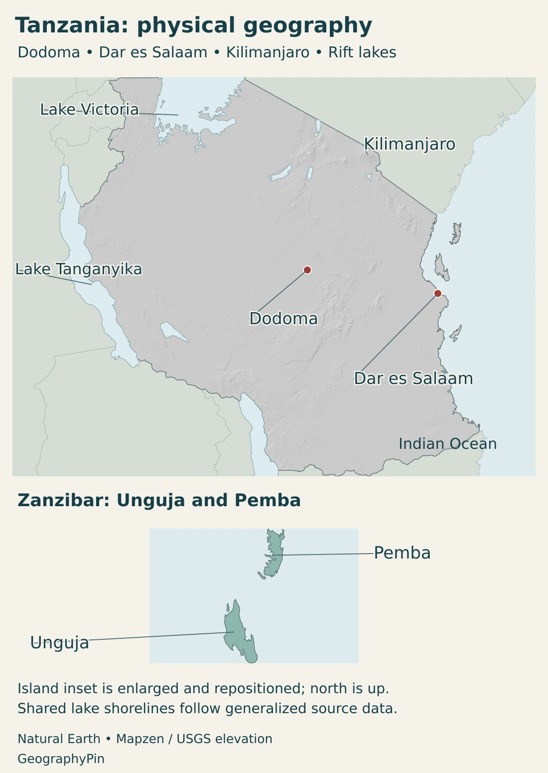
The plateau is not a perfectly flat surface. Hills, valleys and escarpments interrupt it, while mountain blocks rise higher. The journey from the coast to the interior therefore crosses changes in relief as well as distance.
Kilimanjaro rises to about 19,341 ft (5,895 m), the highest point in Africa. It is a volcanic massif on the Tanzanian side of the border region with Kenya. Its great vertical range creates different environments from its lower slopes to the summit; a national description of tropical weather cannot describe conditions across that entire height.
The mountain is not representative of all Tanzanian highlands. Other ranges and uplands have different geological histories and forms. “Highland” is a description of elevation and landscape, not a claim that every mountain block is an active volcano.
Lake Tanganyika occupies part of the western East African rift setting. Its long, narrow form and steep bordering relief contrast with the much broader outline of Lake Victoria farther north. The lakes should not be grouped together as though they have the same basin shape, depth or geological setting.
On the eastern side, coastal lowlands and islands add a maritime dimension. Zanzibar’s separation by sea matters for transport and daily connections even where the islands look close to the mainland at national-map scale.
4. Climate and shared waters
Tanzania’s climate varies with elevation, distance from the ocean and regional circulation. The central plateau includes semi-arid country, whereas the coast is generally hotter and more humid. Mountain settings can be cooler, and lake regions have their own local influences.
Rainfall does not follow one calendar everywhere. The northern coast, northeastern highlands, Lake Victoria basin and Zanzibar commonly experience two rainy seasons: Masika, mainly March–May, and Vuli, mainly October–December.
Much of the south, southwest, center and west instead has one principal rainy period, often extending from November into April or May. These are broad climatic patterns, not guarantees for a particular locality or year. A forecast or rainfall anomaly from one season should not be presented as the country’s permanent climate.
Great Lakes with different outlets and neighbors
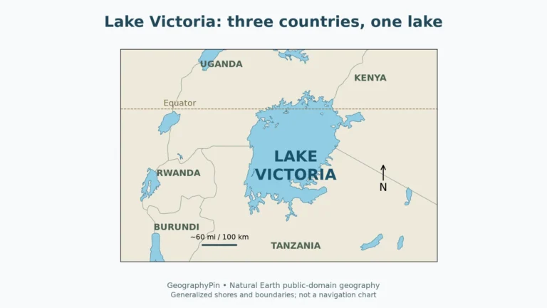
Lake Victoria is shared with Uganda and Kenya and belongs to the upper Nile system. Its wider drainage basin reaches beyond the three countries that share the lake surface. The lake’s shoreline and its catchment boundary are not the same thing.
Lake Tanganyika is shared by Tanzania, the Democratic Republic of the Congo, Burundi and Zambia. Its Lukuga outlet connects it westward with the Congo basin. It therefore does not drain into the Nile merely because it is another East African Great Lake.
These shared waters create common environmental responsibilities. Water quality, fisheries and changes in a catchment can affect people across national borders. A map showing the whole lake provides orientation, but it should not imply that the entire water surface lies within Tanzania.
Lake shorelines also vary with water levels. The generalized outlines used here are geographic references rather than a current water-level survey. Likewise, a published national area including inland water is not equivalent to a dry-land measurement.
5. Cities and the geography of the Union
How Zanzibar and the mainland fit together
Tanganyika and Zanzibar united in 1964. Under the constitutional framework, the government of the United Republic handles Union matters and non-Union matters on the mainland. Zanzibar has its own president, government and House of Representatives for its non-Union affairs. This is one United Republic, not two separate sovereign countries sharing only a name.
Unguja and Pemba are the principal islands of Zanzibar, but the archipelago’s political identity is not simply a physical-region label. Its institutions operate within the United Republic’s constitutional arrangement. Geography helps locate Zanzibar; constitutional sources explain which government handles which matters.
Dodoma’s inland capital role and Dar es Salaam’s coastal commercial role are complementary rather than interchangeable. Mwanza occupies a Lake Victoria setting, while Kigoma lies beside Lake Tanganyika. The differences show how Tanzania’s cities connect administrative functions, maritime trade and inland waters.
An island, a city and an administrative region can share a familiar place name without having the same boundaries. This is particularly important for Zanzibar and for population statistics describing major urban areas. A useful comparison keeps the geographic unit and reference date consistent.
Language in a diverse country
The National Bureau of Statistics lists Kiswahili and English as official languages. Kiswahili has an important role in communication across the country, while many other languages are spoken in communities. The official-language listing does not mean that every resident uses only those two languages or that language use is identical in every setting.
6. Farming, ports and island connections
Tanzania’s farming geography includes important contrasts even within one crop. The Tanzania Coffee Board identifies Arabica-growing settings on the slopes of Kilimanjaro and Mount Meru and in the Southern Highlands, including Mbeya, Songwe and Ruvuma. Robusta is associated especially with Kagera near Lake Victoria.
These locations show why “tropical farming” is too broad an explanation. Elevation, rainfall and local growing conditions help distinguish production areas. A national coffee total does not describe the environment in which every variety is grown.
Dar es Salaam’s port connects Tanzania with overseas shipping and with inland markets beyond the national border. The Tanzania Ports Authority identifies routes serving countries including Zambia, Rwanda, Burundi, Uganda and Malawi, as well as the eastern DRC. These connections serve both landlocked neighbors and inland areas of countries that have coastlines elsewhere.
Port geography is therefore about more than the waterfront. The relationship between ships, terminals and inland transport determines how the coast serves the continental interior. Tanzania’s position on the Indian Ocean gives that connection a different character from the lake routes in the west and north.
Zanzibar adds an island economy and maritime connections to this mainland pattern. Sea crossings separate it from inland road networks, while its constitutional institutions distinguish it from an ordinary mainland locality. The country’s geography makes most sense when mainland and islands are considered together without erasing those differences.
Frequently Asked Questions
Is Zanzibar part of Tanzania?
Yes. Zanzibar forms part of the United Republic of Tanzania. Its main islands are Unguja and Pemba, and it has its own governmental institutions for matters outside the Union framework.
Is Tanzania’s capital Dodoma or Dar es Salaam?
Dodoma is the national capital. Dar es Salaam remains a major commercial center and seaport, which is a different role from legal capital status.
Do Lake Victoria and Lake Tanganyika drain into the same river system?
No. Lake Victoria is connected to the Nile system, while Lake Tanganyika has a westward outlet through the Lukuga toward the Congo basin.
What Did We Learn Today?
Tanzania brings together an extensive mainland and Zanzibar within one United Republic. Dodoma is the capital, while Dar es Salaam links the coast with inland trade. Plateau country, mountain blocks, shared Great Lakes and islands create different climates and connections. Lake Victoria and Tanganyika belong to different drainage systems, and mainland-only data must not be confused with national totals.
Sources & Data Notes
Sources were checked in November 2026. Population and area use the identified national publications, with Union coverage distinguished from mainland-only statistics.
- NBS, National Population Projections 2023–2050: Table A5.4 and Appendix A8: 2026 national projection. The method uses an adjusted 2022 census base; it is not a new enumeration.
- NBS, Tanzania in Figures 2025: Pages 1–2: official languages, currency and rounded national land-plus-water area. The national total includes Zanzibar.
- National Capital City legislation: Sections 2 and 4: Dodoma’s capital status and application to mainland Tanzania and Zanzibar.
- Constitution of the United Republic: Articles 34 and 102–106: Union responsibilities and Zanzibar’s institutions for non-Union matters.
- Tanzanian High Commission, country profile: Union history, broad mainland landscapes and the distinction between Dodoma and Dar es Salaam.
- Tanzania Meteorological Authority, climate statement 2023: Appendix climatology: regional rainfall regimes. The report’s 2023 weather observations are not presented as current conditions.
- UNESCO, Kilimanjaro National Park: Mountain height and volcanic massif; no current glacier-area claim is made.
- FAO, Lake Tanganyika research: Western Rift setting and lake geography; historical numerical inventories are not treated as new surveys.
- Lake Tanganyika Authority, contracting countries: The four riparian countries sharing the lake.
- Burundi’s Lake Tanganyika submission to UNESCO: 2026 state-party submission: Lukuga outlet toward the Congo basin. A tentative-list submission is not a World Heritage inscription.
- Kenya Water Resources Authority, Lake Victoria South Basin: The shared lake and its wider upper-Nile drainage context.
- Tanzania Coffee Board, growing regions: Arabica highland settings and Robusta in Kagera; undated production shares are not used.
- Tanzania Ports Authority, Dar es Salaam: Regional port connections; port capacity and trade-share figures are not required for this geographic overview.
Map sources and scope: Original GeographyPin maps use public-domain Natural Earth country outlines, lake polygons and city coordinate attributes. All Tanzanian components in the source are retained. Small islands are generalized; this is not a complete island inventory or an official territorial-claims map.
The inset enlarges Unguja and Pemba and nearby source island components, preserving their relative positions. It is repositioned and uses a different scale from the main map, where the islands remain in their original geographic positions. The inset remains a flat locator in the physical map. Mafia is retained on the main map and is not assigned to Zanzibar.
Actual generalized lake polygons are shown across neighboring countries, not as wholly Tanzanian waters. No lake or maritime boundary is drawn, including no adjudication of Lake Malawi/Nyasa delimitation. Shorelines are not a current water-level survey. City markers identify source locations, not urban boundaries; Kilimanjaro’s marker locates the massif rather than a surveyed summit.
Main-map hillshade is calculated from real elevations accessed through Mapzen Terrain Tiles. Global elevation data courtesy of the U.S. Geological Survey. Elevation-source attribution and terms apply. Shading shows terrain form, not numerical elevation bands or local navigation detail.
The cover uses Tanzanian flag artwork in a country-outline motif, with an intact flag, decorative divider and GeographyPin branding.