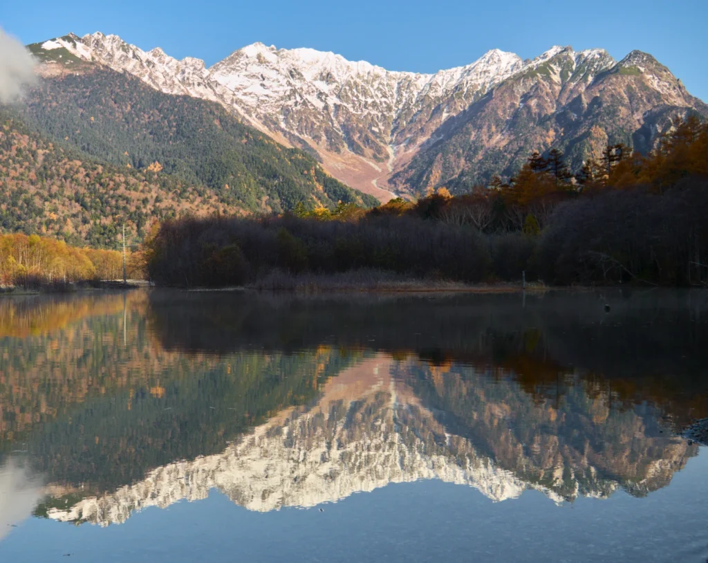
Taishō Pond’s mountain reflections are famous, but the water has a more eventful history than a still photograph suggests. Its geography connects an eruption, a blocked river, sediment from steep slopes and later hydropower management.
Taishō Pond is in Kamikochi, Nagano Prefecture, Japan. It formed in 1915 when material from Yakedake’s eruption dammed the Azusa River. It is a valley pond, not a crater lake, and its present condition also reflects sediment removal and managed water use.
How to use this article: Start with the location, follow the volcanic origin, or explore the managed-water context. The final access section is dated because Kamikochi operates seasonally.
1. Where Is Taishō Pond?
Japan, Nagano and the Kamikochi valley
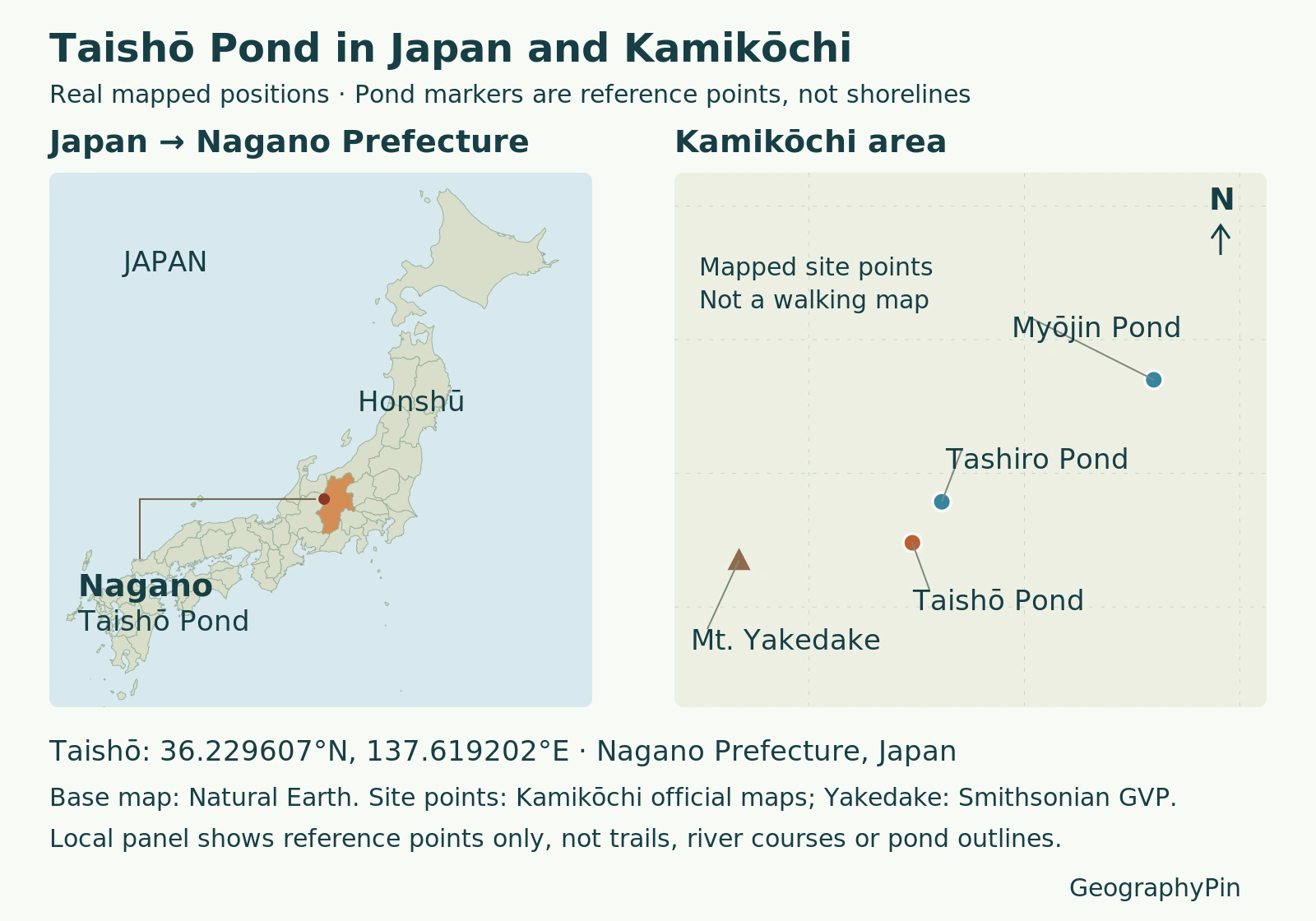
Taishō Pond lies in Kamikochi, within Matsumoto City in Nagano Prefecture. On a map of Japan, look toward the mountainous interior of central Honshu, rather than the coast. The English names Taisho Pond and Taishoike refer to the same place; its Japanese name is 大正池.
Kamikochi belongs to Chubu Sangaku National Park in the Hida Mountains, also called the Northern Japan Alps. The Azusa River runs through the basin, surrounded by forests and steep mountain slopes. Taishō Pond is part of that river-valley landscape, not an isolated pool on a summit.
The locator separates two scales: Japan and Nagano establish the regional position, while the local reference points distinguish Taishō from nearby Tashiro and Myōjin ponds. A plotted point identifies a site; it does not trace the water’s edge or provide a walking route.
2. How the 1915 Eruption Created the Pond
Mud and boulders blocked the Azusa River
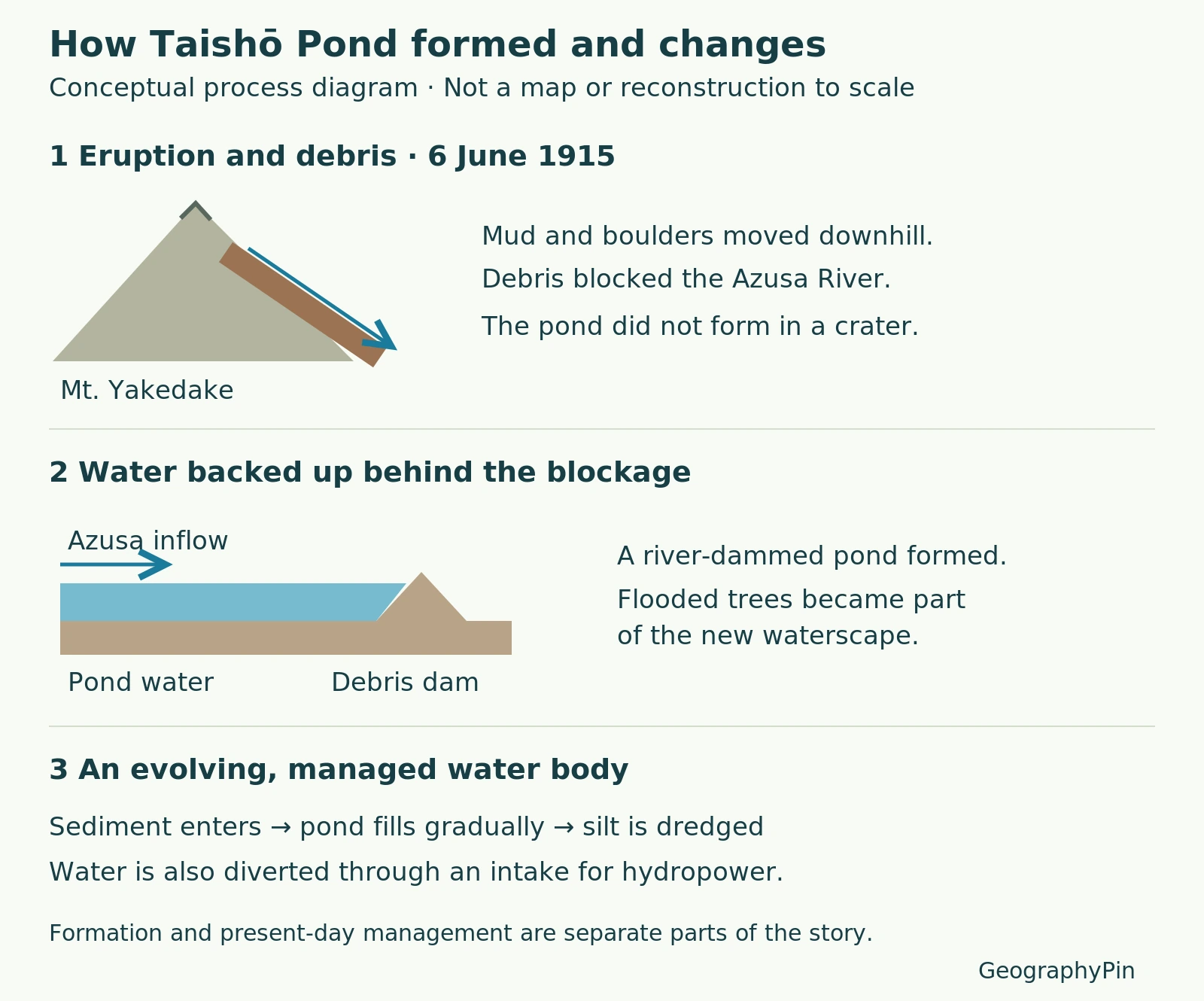
On June 6, 1915, Yakedake erupted. The Japan Tourism Agency’s interpretation describes mud and boulders moving down the mountain slope and obstructing the river. Water backed up behind that material, creating Taishō Pond.
The Smithsonian Global Volcanism Program identifies the pond-forming flow as a lahar, a volcanic mudflow or debris flow. The important distinction is the process: material moved into a river valley and formed a barrier.
That makes Taishō a volcanic-dammed pond, not a crater lake. It did not form by filling the volcano’s summit crater, and describing its origin simply as a river blocked by lava loses the documented role of mud and boulders.
Read the formation diagram as a sequence
- River valley: the Azusa carries water through the mountain landscape.
- Volcanic debris: the 1915 eruption sends material down the slope into the channel.
- Impounded water: the obstruction holds water back, forming the pond.
- Continuing change: sediment delivery and later water management reshape the water body.
This sequence explains cause and effect. It is not a reconstruction of exact 1915 depths, debris volumes or channel dimensions.
3. The Valley, Mountains and Standing Trees
Yakedake stands west of Taishō Pond, while the Hotaka mountains form another prominent part of Kamikochi’s setting. The famous reflections connect the water surface visually with the mountains above it, but those mountains also belong to the pond’s physical story.
The surrounding slopes supply material to the valley, and the river links the pond to water arriving from farther upstream. A still reflection can therefore hide a moving system: water passes through the valley while sediment is transported, deposited or removed.
The dead tree trunks associated with Taishō Pond are another clue to its history. The official Kamikochi description links the submerged trees with the volcanic event, and Matsumoto’s tourism account notes that fewer standing trees remain than in the past. They are remnants of a changed landscape, not a permanent arrangement of scenic objects.
When comparing photographs from different periods, keep the photograph’s date and viewpoint in mind. A different number of visible trunks or a different-looking margin does not, by itself, measure a change in the pond’s total area.
4. Why the Water Body Is Still Changing
Sediment accumulation and dredging
The pond’s natural origin does not mean it has remained untouched. Kamikochi’s official account describes incoming mountain debris, annual silt dredging and artificial maintenance of the dam.
Sediment occupies space that was previously water-filled. Without distinguishing that gradual infilling from short-term changes in water level, it is easy to misread what a shallow margin or exposed patch means. The sources establish an ongoing sediment problem; they do not supply a fixed shoreline that can be treated as permanent.
A natural origin with later managed water
The Japan Tourism Agency identifies an intake at the pond’s west end that sends water to the Kasumizawa Power Station near Sawando. Taishō Pond thus also forms part of a hydroelectric water system.
Keep the chronology clear: volcanic debris created the original obstruction in 1915; later infrastructure and maintenance help explain the present managed water body. “Natural” and “managed” describe different parts of its history rather than mutually exclusive labels.
For the broader concepts, see how ponds receive and lose water and the geographic definition of a lake. Here, origin, river connections and maintenance are more informative than choosing between the everyday words pond and lake.
5. Taishō, Tashiro and Myōjin Are Different Ponds
The similar names can be confusing, especially when reading a walking itinerary. These are separate places, not alternative spellings for one pond.
| Pond | How to distinguish it | Key context |
|---|---|---|
| Taishō / Taishoike | The pond created by the 1915 volcanic obstruction | Azusa River, standing trees and managed water |
| Tashiro | A smaller pond beside the route between Taishō and Kappa Bridge | Groundwater supply and surrounding marsh |
| Myōjin / Myojinike | A separate destination beyond the Kappa Bridge area | Hotaka Shrine and a forested pond setting |
Tashiro is fed by groundwater from the surrounding mountains. The Japan Tourism Agency describes sediment and accumulated plant material gradually transforming it toward wetland. That is a different explanation from Taishō’s documented 1915 river damming.
Myōjin Pond has particular religious significance through its association with Hotaka Shrine. The official visitor description places it about an hour’s walk from the Kappa Bridge area. Do not transfer Taishō’s volcanic origin to Myōjin simply because both appear on the same Kamikochi itinerary.
6. Access: Seasonal, Not Year-Round Sightseeing
Access status as of November 17, 2026: Kamikochi’s regular 2026 visitor season has ended. The official notice published November 16 confirms the seasonal closure. The preceding announcement says buses do not enter during the winter off-season and describes reopening in April 2027.
During the operating season, visitors approaching by car leave it outside Kamikochi, commonly at Sawando or Hirayu, and transfer to a bus or taxi. Private cars and motorcycles are not allowed into Kamikochi. These normal-season arrangements should not be read as services available during the current closure.
Before planning a visit, consult the official season-end notice, current Kamikochi announcements and official access information. Winter mountain access is not the same as ordinary summer sightseeing; this geography guide does not establish current trail, snow or volcanic conditions.
Frequently Asked Questions
Is Taishoike another pond?
No. Taishoike and Taishō Pond are names for the same Kamikochi water body. Tashiro Pond, despite its similar-looking name, is a separate nearby site.
Does the map show an exact historical shoreline?
No. The locator identifies places, while the process diagram explains the formation sequence. Neither is a surveyed reconstruction of the pond in 1915.
What Did We Learn Today?
Taishō Pond makes sense as part of the Azusa valley: volcanic debris created a barrier, the river supplied water, sediment continued arriving, and later management influenced the pond that survives today. Its location, origin and changing water system distinguish it from the nearby Tashiro and Myōjin ponds.
Sources & Data Notes
Formation and water-management details follow Japanese official interpretation and the Smithsonian volcano profile. Local map points are approximate references from official spot-page maps, not shoreline surveys. The process illustration is conceptual. Access information is dated November 17, 2026 and is separate from the enduring geographic description.
Cover photo: lumoplank, Taishō Pond and the Hotaka mountains, November 7, 2025, CC0 1.0. Original locator base: Natural Earth public-domain geography; local points from the official spot maps and Smithsonian profile below. Original process diagram: GeographyPin, based on the Japan Tourism Agency and Kamikochi descriptions.

- Kamikochi: Taisho Pond
- Japan Tourism Agency: Taishō Pond
- Smithsonian Global Volcanism Program: Yakedake
- Matsumoto City: Taishō Pond
- Kamikochi: National Park
- Kamikochi: Tashiro Pond
- Japan Tourism Agency: Tashiro Pond and Wetland
- Kamikochi: Myojin Pond
- Kamikochi: End of the 2026 Season
- Kamikochi: Season End
- Kamikochi: Access by Car