Sweden stretches from southern farmland and large lakes to forested northern interiors and mountains along Norway. The contrast is not simply “warm south, frozen north”: elevation, coastlines and the shelter of the Scandinavian Mountains also shape local conditions. Its cities, waterways and resource industries make more sense when viewed against that varied physical map.
Sweden is a country in Northern Europe on the eastern side of the Scandinavian Peninsula, with Stockholm as its capital. It borders Norway and Finland and faces the Baltic Sea and Gulf of Bothnia. Its main geographic contrasts are the northwestern mountains, extensive forests, large southern lakes and more densely settled southern and coastal areas. Gotland is a Swedish island in the Baltic Sea.
How to use this article: Clarify Scandinavia and the Nordic region, compare north and south, or follow the large lakes’ different outlets.
1. Locate Sweden on the Scandinavian Peninsula
Sweden lies east of Norway and southwest of Finland. The Gulf of Bothnia separates much of Sweden’s eastern coast from Finland, while a land border connects the countries in the far north. To the south, Sweden faces Denmark across narrow waters rather than sharing a land frontier.
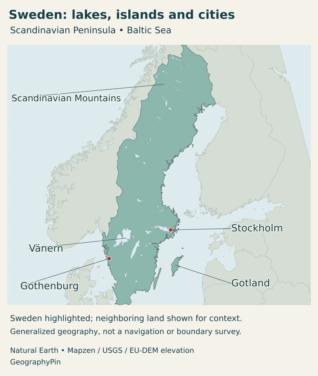
Stockholm stands on the Baltic side of the country. Gothenburg, or Göteborg in Swedish, lies on the west coast. These two locations face different maritime approaches, helping explain why Sweden’s coastal geography cannot be reduced to one uniform shoreline.
Sweden is both Scandinavian and Nordic
Sweden belongs to Scandinavia and to the wider Nordic region. In the common country grouping, Scandinavia comprises Sweden, Norway and Denmark. The Nordic grouping also includes Finland and Iceland, together with associated autonomous territories.
The Scandinavian Peninsula is a physical landmass, not exactly the same thing as that cultural and country grouping. Denmark is included in the usual Scandinavian country group even though it does not occupy the peninsula.
Our Scandinavia versus Nordic countries guide explains those conventions. The Baltic Sea profile covers the larger sea system facing Sweden’s eastern and southern coasts.
2. Country facts with dates and definitions
| Measure | Value | Date or definition |
|---|---|---|
| Capital | Stockholm | National capital; city and county are different units. |
| Population | 10,621,725 | Preliminary population-register total, September 2026. |
| Land plus inland water | About 173,750 sq mi (450,020 km²) | Calculated from SCB January 1, 2026 categories; excludes sea area. |
| Land category | About 158,160 sq mi (409,629 km²) | SCB January 1, 2026 land category; small water features may fall within this category. |
| Principal language | Swedish | Language Act wording; national minority languages and Swedish Sign Language have separate protections. |
| Currency | Swedish krona (SEK) | Not the euro. |
| Administration | 21 counties and 290 municipalities | Counties, elected regions and historical provinces are distinct concepts. |
| Government | Constitutional monarchy with parliamentary government | Monarch as head of state; prime minister leads the government. |
The population figure is register-based and preliminary for the stated reference period. It is not a count of Swedish citizens alone. Similarly, a Stockholm county figure covers a much larger area than Stockholm municipality or the continuously built-up urban settlement.
Area figures need their own definitions because Sweden has substantial inland water. Land, inland water and sea area are separate statistical categories. Combining a land-only figure with a total-area figure without explaining the difference would produce a misleading comparison.
3. Northern mountains, forests and southern lake country
How the main landscapes differ
| Setting | Landscape | Geographic consequence |
|---|---|---|
| Northwestern mountain belt | Scandinavian Mountains near the Norwegian frontier. | Elevation and exposure create alpine conditions that differ sharply from nearby lower country. |
| Northern forest and river country | Extensive forests, wetlands and long river valleys. | Settlement, transport and resource activities concentrate along particular corridors rather than spreading evenly. |
| Central and southern lake country | Large lakes, lower terrain and varied glacial deposits. | Waterways and settled lowlands coexist with forested and rocky ground. |
| Southern plains and uplands | Agricultural lowlands alongside the South Swedish Highlands. | The south is neither uniformly flat nor exclusively farmland. |
| Baltic islands and coast | Gotland, archipelagos and long coastal stretches. | Island and coastal settings have distinct connections, exposure and habitats. |

The Scandinavian Mountains occupy Sweden’s northwestern side rather than running down the country’s center. Their climate and vegetation vary with altitude and whether slopes face incoming moist air or lie in shelter. Alpine terrain and mountain birch belts are different environments from the coniferous forests below.
Forests occupy much of the wider landscape, but forest should not be treated as another word for untouched wilderness. National parks protect selected habitats, while other wooded areas have long histories of use and management. Wetlands, rivers and settlements interrupt the forest cover.
Farther south, Vänern and Vättern are prominent features on the map. Surrounding lowlands contrast with uplands such as the South Swedish Highlands. Southern Sweden therefore contains several physical settings within a comparatively short distance.
Bedrock and ice both shaped the surface
Much of Sweden belongs to the Fennoscandian Shield, with old crystalline and metamorphic rocks. Bedrock is only part of the story: repeated glaciation and melting also left deposits and reshaped the surface.
Till, a mixture of material deposited by ice, is widespread. Rock type and the overlying deposits help influence soils, groundwater and land use. A green surface on a landscape photograph may therefore conceal very different conditions beneath it.
Gotland provides an island contrast. It lies in the Baltic rather than in the mountain belt and has important limestone landscapes. Its setting should not be confused with the forested mainland or with a fragment of the Scandinavian Mountains.
The regional labels in this profile describe broad landscapes. They are not county boundaries, and they do not imply that every place inside a region has identical terrain or vegetation.
4. Climate, daylight and connected waters
Sweden’s elongated north–south shape produces large differences in seasons and growing conditions. Northern inland areas generally have longer, colder winters than the south, while elevation and proximity to water add local variation.
Mountains modify the Atlantic influence. Moist air arriving from the west rises over high ground, releasing precipitation; sheltered areas farther east can be relatively drier. The west coast has a stronger maritime character, while inland locations can experience larger seasonal temperature ranges.
Water availability also varies through the year. An area with an annual surplus of precipitation can still experience summer water stress when evaporation and plant water use are high. A national climate average is therefore not a reliable description of every farm, forest or catchment.
Midnight sun is a northern phenomenon
In the far north, summer includes periods when the sun does not set, while winter can include periods when it does not rise. These are the midnight sun and polar night. Their duration depends on latitude, with local horizon and atmospheric effects influencing observed sunrise and sunset.
This does not describe all of Sweden. Stockholm and the southern cities have long summer days and short winter days, but not the same continuous daylight or polar-night pattern as the far north. Polar night also does not mean the complete absence of twilight throughout the day.
Vänern and Vättern drain in different directions
Vänern is Sweden’s largest lake. Water leaves it through the Göta älv system, including the Nordre älv branch, toward the west-coast sea. Its catchment is much larger than the lake surface itself.
Vättern lies farther east in a fault depression. Its outlet follows Motala ström toward Bråviken in the Baltic Sea. Two large lakes close together on a national map can therefore belong to different drainage routes.
Water levels and outflows are also affected by regulation. A lake outline is not a measurement of its present level, and a blue river line cannot show whether flow is natural, seasonal or managed. The distinction matters when interpreting hydropower, flood conditions and freshwater habitats.
5. Cities, regional settlement and languages
Stockholm is the national capital on the Baltic side, while Gothenburg is a major west-coast urban and port center. Malmö lies in the far south near Denmark. Together, these locations illustrate the stronger urban concentration in the southern part of the country.
The north is less densely settled overall, but it is not empty. Towns, transport corridors, resource industries and established communities occupy particular places within the extensive forest and mountain landscape. A low average density can conceal important local concentrations.
Sweden has 21 counties and 290 municipalities. Historical provinces are another geographic framework and should not be substituted for current administrative units. County administrative boards represent central government, while elected regions and municipalities perform their own functions.
Principal and minority languages
The Language Act identifies Swedish as the principal language. It also recognizes Finnish, Yiddish, Meänkieli, Romani Chib and Sámi as national minority languages. Swedish Sign Language is separately protected. These legal categories should not be collapsed into a claim that only one language matters in public life.
The Sámi are an Indigenous people as well as a recognized national minority in Sweden. Their presence should not be reduced to a symbol on a northern landscape map. Language, culture and community interests are part of the human geography of the country, alongside those of other established minorities.
English forms such as Gothenburg and Swedish forms such as Göteborg refer to the same city. Diacritics in names such as Vänern, Vättern and Öland help preserve the correct place names rather than representing separate locations.
6. Government, resources and transport connections
Sweden is a constitutional monarchy with parliamentary government. The monarch is head of state, while the prime minister leads the government. The Riksdag is the national parliament. These roles differ from those of counties, elected regions and municipalities.
Sweden’s economic geography links resources and production areas with cities, energy systems and transport routes. Forests, ore deposits and rivers matter, but none of them alone explains the modern economy.
For a separate institutional view, our guide to Sweden’s markets, welfare and ownership distinguishes private enterprise, public shareholdings and social protection.
Mining provides a concrete regional example. Geological Survey of Sweden identifies Norrbotten, the Skellefte district and Bergslagen as major ore regions. Aitik, south of Gällivare in the north, is a copper-mining example; iron ore is another major part of the national mineral sector.
These activities require connections beyond the mine itself. Processing, electricity supply and freight transport link resource locations with wider industrial networks. Describing northern Sweden only as sparsely populated forest would miss that industrial geography.
Gothenburg illustrates the coastal end of those connections. Its port handles several cargo types and is linked to inland terminals by rail. A port’s reach therefore extends into places that have no coastline of their own.
Freshwater systems create another connection between physical and economic geography. Hydropower production depends on catchment inflows and the management of water. Changes in rain and snow can affect the timing of that supply, so an energy landscape is also a water landscape.
The central lesson is that Sweden’s north–south contrast is real but incomplete. Mountains, forests, lakes, southern lowlands and the Baltic coast form a connected country whose local differences cannot be explained by latitude alone.
Frequently Asked Questions
Is all of Sweden inside the Arctic Circle?
No. Only the far north lies within the Arctic Circle. Stockholm, Gothenburg and Malmö are farther south, so Sweden’s northern daylight extremes should not be applied to the whole country.
Do Vänern and Vättern flow into the same sea?
Their outlets take different routes. Vänern drains through the Göta älv system toward the west coast, while Vättern drains through Motala ström to Bråviken in the Baltic Sea.
Is Gotland part of Sweden?
Yes. Gotland is a Swedish island in the Baltic Sea. Its island setting and limestone landscape differ from the northwestern mountain belt and much of the forested mainland.
What Did We Learn Today?
Sweden combines northwestern mountains, extensive forest country, major lakes and varied southern and coastal landscapes. Latitude matters, but elevation, exposure and water connections also shape local conditions. Stockholm and Gothenburg face different coasts, and even nearby large lakes follow different drainage routes. These physical patterns help explain settlement, resources and transport.
Sources & Data Notes
Reviewed in November 2026. Population is a preliminary September register figure. The area comparison uses SCB’s January 2026 categories, with inland water included and sea area excluded from the calculated combined figure. City, county and regional statistics are not interchangeable.
- Nordic Council of Ministers, Sweden geography: Neighbors, southern farmland, northern settlement pattern and constitutional-monarchy context.
- Statistics Sweden, third-quarter population statistics 2026: September 2026 preliminary total: 10,621,725, based on population registration rather than citizenship alone.
- Statistics Sweden, land and water area: January 1, 2026: land 409,629.20 km², inland water excluding four large lakes 31,520.59 km², and those lakes 8,869.86 km². Their sum is 450,019.65 km², rounded here to 450,020; sea area is excluded. SCB’s all-category total includes sea area. From 2025 the calculation uses a flat SWEREF 99 TM method, so older methods are not directly interchangeable.
- Statistics Sweden, geographical divisions: Twenty-one counties and 290 municipalities; administrative definitions.
- Government of Sweden, Language Act: Swedish as principal language, national minority languages and separate protection for Swedish Sign Language.
- Government of Sweden, national minorities: November 2026 explanation of minority languages and the Sámi as an Indigenous people.
- Riksdag, parliament in Swedish society: National institutions, parliamentary government and regional/local functions.
- Sveriges Riksbank, notes and coins: Swedish currency and the central bank’s cash information.
- Geological Survey of Sweden, geology: Fennoscandian Shield, bedrock and glacial deposits.
- Sweden’s national parks, habitat types: Mountain, forest, wetland, freshwater and coastal habitat contrasts.
- SMHI, Scandinavian Mountains: Mountain position and differences associated with altitude, exposure and vegetation.
- Swedish University of Agricultural Sciences, climate: North–south differences, mountain shelter, maritime influence and seasonal water balance.
- SMHI, midnight sun and polar night: Latitude, horizon and atmospheric effects on seasonal daylight.
- SMHI, Vänern: Largest Swedish lake, Göta älv and Nordre älv outlets, catchment and regulation.
- SMHI, Vättern: Fault-depression setting and outlet through Motala ström to Bråviken.
- Geological Survey of Sweden, Gotland’s limestone and water: Geological context for limestone on Gotland.
- Geological Survey of Sweden, Swedish mines: Ore regions and the Aitik example; no current mine count is reproduced.
- Port of Gothenburg, facts and figures: Port location, cargo variety and inland rail connections.
- International Energy Agency, Swedish climate resilience: Hydropower’s dependence on rainfall, runoff and water management; qualitative relationship rather than a new forecast.
Map sources and scope: Original GeographyPin maps use public-domain Natural Earth country geometry, populated-place coordinate attributes and lake polygons. All Swedish source components are retained, including Gotland, Öland and represented archipelago parts. The source scale does not provide an exhaustive inventory of every small island or an official boundary survey.
Stockholm and Gothenburg markers use source city coordinates, not county centroids. Mountain and regional labels indicate broad geographic settings rather than surveyed natural-region boundaries. Lake outlines are generalized reference geometry, not current water levels or shoreline observations.
Hillshade uses genuine elevations accessed through Mapzen Terrain Tiles. Global elevation data courtesy of the U.S. Geological Survey. Produced using Copernicus data and information funded by the European Union – EU-DEM layers. Elevation-source attribution and terms apply. Shading has no vertical exaggeration and is not ocean bathymetry or a set of numerical elevation bands.
The cover uses Swedish flag artwork from Commons with the national outline. A complete flag is shown separately from the decorative silhouette motif.