Poland’s landscape changes markedly between the southern mountains and the Baltic shore. The country is predominantly low-lying, yet its lakes, river valleys, dunes and mountain edges tell very different stories. This profile follows those contrasts from south to north, with maps and dated facts to keep the national picture clear.
Poland is a Central European country bordered by seven countries and the Baltic Sea. Its geography includes the Carpathians and Sudetes in the south, extensive lowlands, northern glacial lake districts and a varied coast. The Vistula and Oder are major river systems. Warsaw is the capital, and the official language is Polish.
How to use this article: Follow the south-to-north pattern, compare the two mountain systems, or explore glacial lowlands and the Baltic coast.
1. Where is Poland?
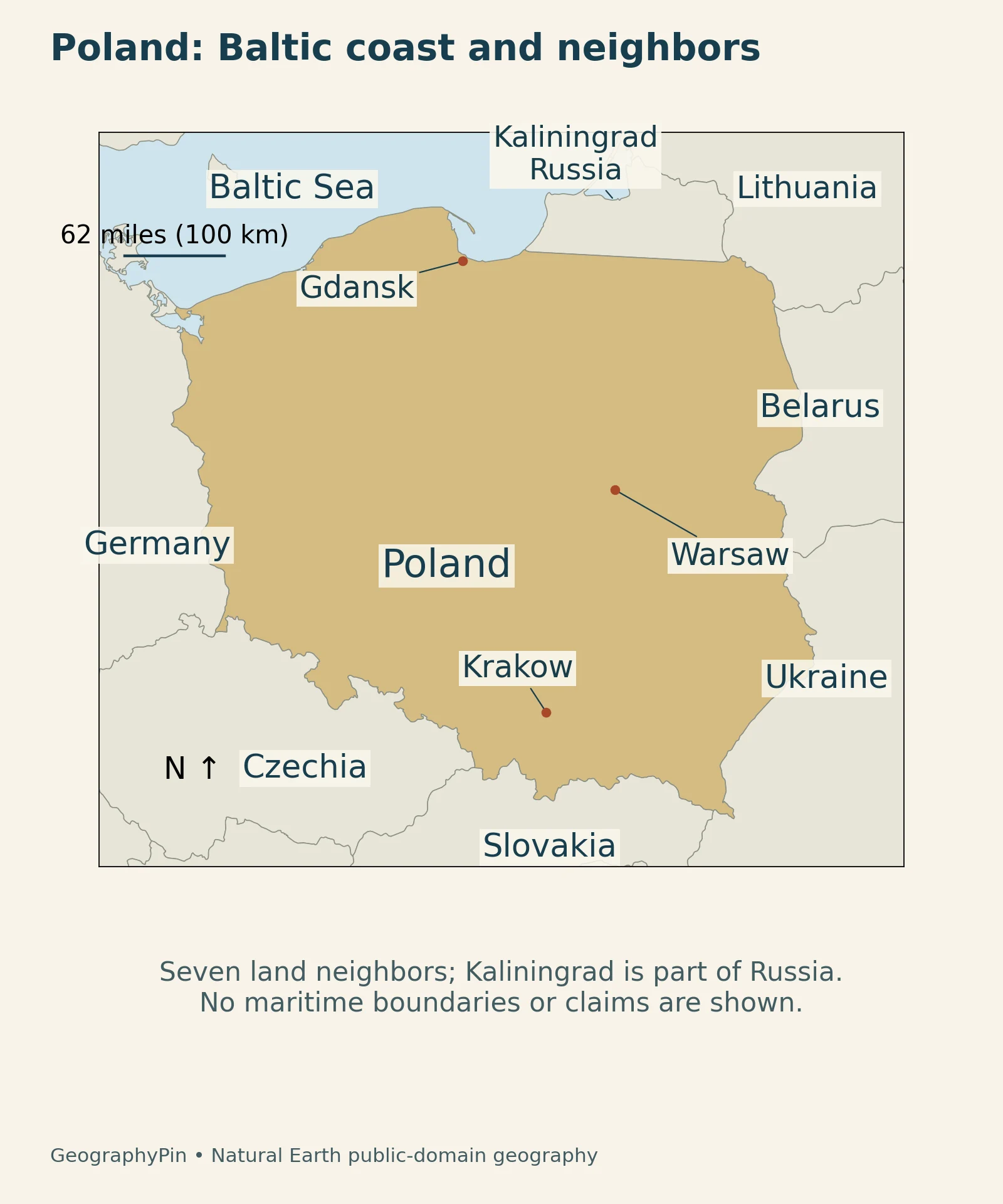
Poland lies in Central Europe, with the Baltic Sea to the north and mountain ranges along parts of its southern border. Its seven land neighbors are Germany, Czechia, Slovakia, Ukraine, Belarus, Lithuania and Russia. The Russian border is with the Kaliningrad exclave, not with Russia’s main territory.
Read the landscape from south to north
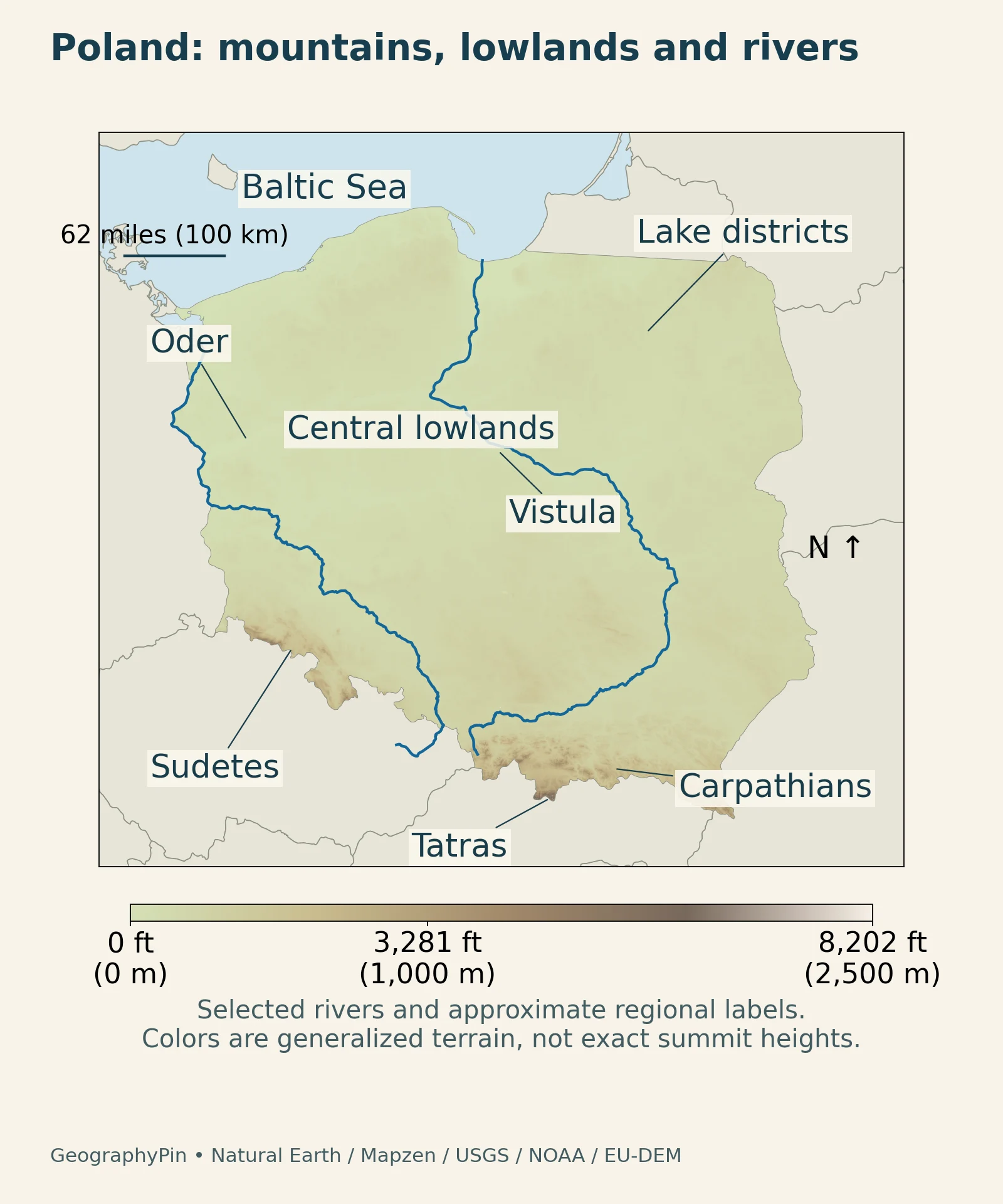
The most useful first picture is a broad sequence: southern mountains, extensive lower country, northern lake districts and the Baltic coast. These are landscape patterns rather than four sharply bounded administrative regions. The relief map below helps connect the country’s different settings without treating every place at the same latitude as identical.
2. Country facts and their dates
| Topic | Fact | Reference or scope |
|---|---|---|
| Capital | Warsaw | National capital |
| Population | About 37.2 million | Preliminary estimate at the end of September 2026 |
| Territorial area | About 121,200 sq mi (313,933 km²) | 2025 official measure: land and part of internal waters |
| Official language | Polish | National official language |
| Currency | Polish złoty (PLN) | National currency |
| First-level administration | 16 voivodeships | Regional administrative divisions |
The Statistics Poland population release gives a preliminary total of 37.212 million for the end of September 2026. The rounded figure above is not a census count or a whole-year average. The territorial-area table uses land and part of internal waters, with its reference date at the beginning of 2025; it is not a land-only measurement.
The government overview identifies Warsaw as the capital and describes the country’s sixteen voivodeships. Administrative divisions organize public functions; they are not the same as mountain ranges, drainage basins or lake districts. For a place-by-place introduction, see our separate guide to cities in Poland.
3. Southern mountains and Tatra lakes
The Carpathians and Sudetes are different mountain systems
Southern Poland includes parts of the Carpathians and the Sudetes. The Tatras belong to the Carpathian system; the Karkonosze are part of the Sudetes farther west. Naming the systems separately avoids treating the entire southern edge as a single continuous range with one geological history.
The Karkonosze National Park’s geomorphology account describes a landscape shaped by uplift, erosion and deeply cut river valleys. Summit surfaces and steep valley sides coexist. Calling a mountain system “old” therefore does not mean that its present topography has remained unchanged since its rocks formed.
Glaciation also left local mountain features. In the western Karkonosze, the Śnieżne Kotły cirques contain steep glacial hollows and small tarns in a granite landscape. They are a mountain-scale example, different from the much broader ice-sheet landscapes of northern Poland.
The Tatras combine different rocks with glacial relief
The Tatra National Park geology account distinguishes a crystalline core, including granitoids and metamorphic rocks, from sedimentary rocks such as limestone, dolomite, marl and sandstone. The Tatras are not made entirely of granite. Their rock structure and later erosion together help explain the contrast between rugged ridges, valleys and limestone terrain.
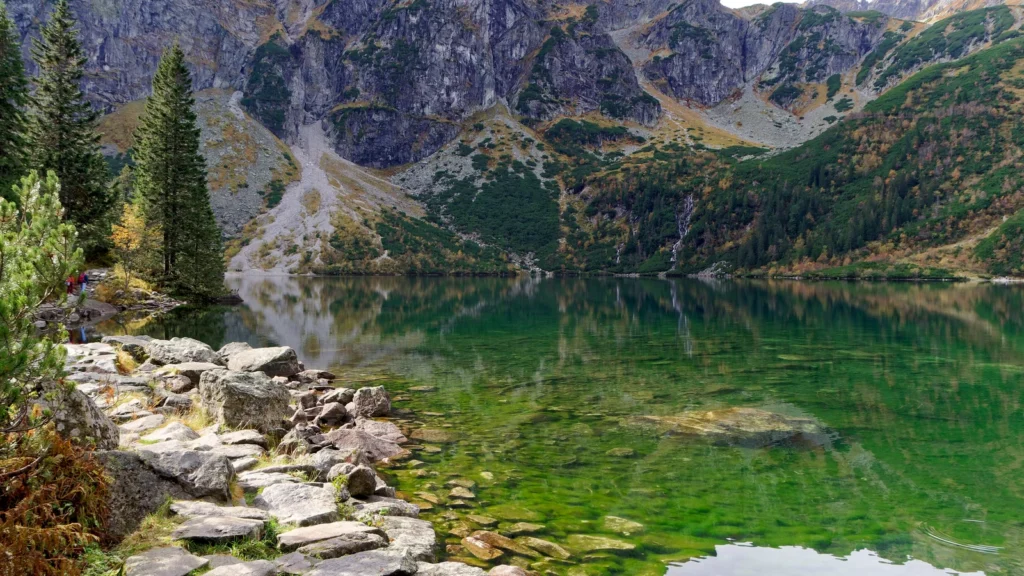
Mountain glaciers carved cirques and U-shaped valleys and left rock steps, hanging valleys and moraines. The featured photograph of Morskie Oko shows a lake beneath steep Tatra slopes, not a typical view of Poland’s predominantly lower terrain. Our Czarny Staw Gąsienicowy guide explores another lake in this mountain setting.
The park’s account of its waters also describes streams and springs. In limestone terrain, water can enter cracks and move underground before emerging at a spring. Visible surface channels therefore tell only part of the drainage story. A mountain lake, a stream and a karst spring represent different ways that water moves through the landscape.
4. Lowlands and northern lake districts
Lowlands are not featureless plains
The Statistics Poland environmental overview emphasizes the importance of low country in the national landscape. Lower elevation does not mean an absence of relief: river valleys, ridges, depressions and locally rolling terrain can be important even where mountains are absent.
Poland’s northern lake districts retain landforms associated with continental ice and meltwater. The national education platform’s glacial-landscape guide explains features such as moraine hills, long meltwater-cut depressions and ice-marginal valleys. Lakes occupy some depressions, giving northern landscapes a different appearance from many older, more subdued plains farther south.
The distinction is not simply “glaciated north” versus “unglaciated centre.” Older glacial terrain has had longer to be reworked by rivers and other surface processes. The freshness of landforms matters alongside the fact that ice once reached a place. Mountain glaciation in the Tatras is a separate setting from the northern ice-sheet story.
Białowieża adds a forest landscape to the lowland picture
On the border with Belarus, Białowieża Forest illustrates another side of the lowlands. UNESCO describes a complex of mixed forests with extensive old-growth areas, alongside wet meadows, river valleys and wetlands. Standing and fallen dead wood supports fungi and invertebrates; the European bison is an emblematic large mammal of the forest.
This is a transboundary forest complex, not a synonym for all Polish woodland. It shows why the height of the ground alone cannot describe a landscape: vegetation, water, habitat connections and the history of protection also matter. Low country can contain ecologically complex terrain even where a national relief map shows little color contrast.
5. Rivers and the Baltic coast
The Vistula and Oder connect inland regions to the sea
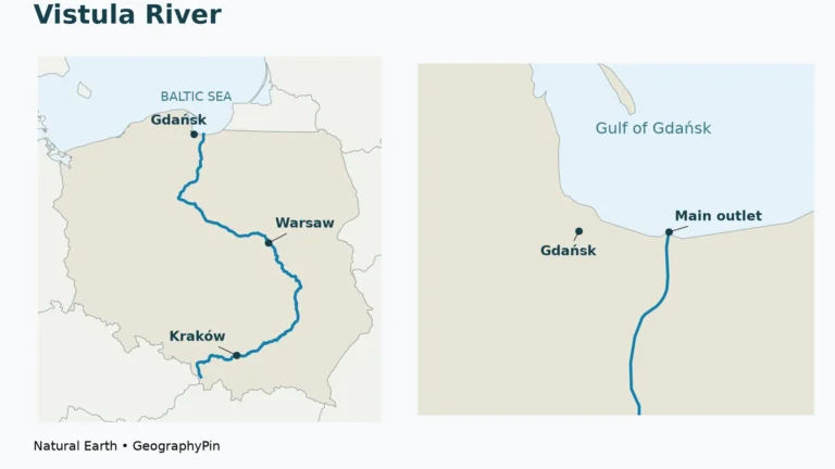
The Vistula and Oder are the two major river systems shown on the map. They link different landscapes instead of staying within a single physical region. Their catchments and tributaries matter more for understanding drainage than a straight line between a source and the coast.
The Vistula River guide follows the river from the southern mountains through inland cities toward the Baltic. Its main modern outlet is east of central Gdańsk, near Świbno; the map’s generalized river line should not be used to identify individual delta channels.
River behavior varies along the course and through time. A study of Vistula flow regimes analyzed records from 1971–2010 and found the most frequent flow-regime changes in the river’s upper, mountainous reaches, under the influence of its tributaries. That evidence helps explain why a river’s national importance does not translate into one uniform flow pattern from headwaters to mouth.
The Oder is also a cross-border system. The international river commission describes its basin across Czechia, Poland and Germany. Water-management cooperation follows the connected river system, not just national boundaries. A basin is the area that drains into a river; the broader administrative river-basin district used by authorities is a related but distinct reporting unit.
The Baltic shore includes more than beaches
The Baltic Sea gives Poland a northern coast, but that coast contains a variety of landforms. At Słowiński National Park, the Polish Tourism Organisation describes moving dunes, coastal lakes, peat bogs, meadows and woodland. Wind-driven sand can cover vegetation and expose the remains of older woodland.
A lake behind the coast, a dune ridge and the open sea are adjacent but different environments. This coastal example completes the south-to-north comparison: Tatra glacial hollows, northern ice-sheet depressions and Baltic dunes are all landforms shaped by moving material, but through different processes and at different scales.
6. Climate across contrasting terrain
Maritime and continental influences meet
The Polish National Agency for Academic Exchange’s climate overview describes a temperate climate influenced by both maritime and continental air. This broad transition is a better starting point than labeling the entire country either oceanic or continental. Winters are generally cold, while summer conditions can vary considerably between hot and rainy periods.
7. Economy in its geographic setting
Economic regions do not mirror physical regions exactly
Natural resources are one part of the economic setting. The Statistics Poland environmental report identifies resources including coal, lignite, copper ores and rock salt. Their distribution adds another layer to a physical map, but a resource map alone cannot explain the locations of services, administration or every industrial centre.
The official regional accounts for 2024, published in September 2026 show economic production concentrated in several large regional economies. The Warsaw capital statistical region, Śląskie, Wielkopolskie, Dolnośląskie and Małopolskie together accounted for more than half of national GDP. The capital statistical region is not merely the city of Warsaw, and regional GDP is not a household-income measure.
Keeping these layers separate makes the country profile more useful: the locator shows political neighbors, the relief map shows terrain, and the dated tables describe administrative or statistical units. None of those maps can substitute for all the others.
What Did We Learn Today?
Poland is not one uniform plain. Southern mountain systems, extensive lower terrain, northern glacial landscapes and the Baltic coast create a clear national pattern with many local variations. Rivers connect those settings, while rock type, ice, flowing water and wind explain different landforms. Population, territorial area and economic figures add useful context only when their dates and geographic definitions stay attached.
Sources & Data Notes
Population is the preliminary end-September 2026 estimate. Area uses Statistics Poland’s 2025 territorial measure of land and part of internal waters, not an undated land-only figure. Economic accounts refer to 2024 and were released in 2026. Historical river studies support process explanations, not current flood forecasts.
- Polish government: country and administrative overview
- Statistics Poland: preliminary population, September 2026
- Statistics Poland: selected national data, territorial area for 2025
- Statistics Poland: natural geography and resources, 2022 report
- Polish education platform: young and old glacial landscapes
- Karkonosze National Park: geomorphology
- Karkonosze National Park: glacial cirques
- Polish Tourism Organisation: Słowiński National Park
- Tatra National Park: geology and glacial landforms
- Tatra National Park: lakes, streams and springs
- International Commission for the Protection of the Odra River: basin geography
- Statistics Poland: 2024 regional GDP, published September 2026
- NAWA: Poland’s climate
- Wrzesiński and Sobkowiak, 2020: changes in the Vistula’s flow regime
- UNESCO: Białowieża Forest, transboundary lowland ecosystems
Maps: GeographyPin, using Natural Earth public-domain country and river geometry. Relief uses actual Mapzen terrain data, with attribution to USGS SRTM/GMTED2010, NOAA ETOPO1 and European Union-funded Copernicus EU-DEM. Regional labels are approximate locations, not mapped boundaries. Selected rivers and generalized elevations are unsuitable for navigation or exact summit measurements.
Featured photograph: Morskie Oko, October 10, 2020, Jakub Hałun / Wikimedia Commons, CC BY-SA 4.0. Cropped and resized; the derivative retains the same license.