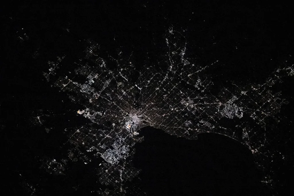
Melbourne’s skyline occupies only a small part of its geographic setting. Follow the Yarra downstream and the city opens toward Port Phillip; look west and broad plains replace the more broken ground of the eastern suburbs. Understanding those connections explains more than treating Melbourne as a single point on a map.
Melbourne is the capital of Victoria in southeastern Australia, centered on the lower Yarra River near the northern end of Port Phillip. Its wider metropolitan region extends across western volcanic plains and eastern hills. The bay connects to Bass Strait through a narrow southern entrance between Point Lonsdale and Point Nepean.
Read Melbourne in three layers: Start with the city’s boundaries, follow the Yarra to the bay, then compare the plains and hills.
1. Where is Melbourne, and what does the name include?
City center, municipality and metropolitan region
Melbourne sits in southern Victoria, on the Australian mainland. The central business district lies beside the Yarra, inland from the bay’s northern shore. Port Phillip is the large body of water south of the central city, not an open-ocean coastline immediately beyond downtown. The route from the river to the sea passes through the bay first.
“Melbourne” can describe different areas. The City of Melbourne is a local government municipality covering the central city and surrounding inner neighborhoods. The broader metropolitan region includes many municipalities and a much larger spread of suburbs. These are not interchangeable boundaries for population, land area or density.
For population, this article uses the Australian Bureau of Statistics’ Greater Melbourne Greater Capital City Statistical Area, or GCCSA. Its estimated resident population was about 5.44 million on June 30, 2025. That is a metropolitan statistical estimate, not the number of people living in the City of Melbourne municipality. Naming both the boundary and the date makes the figure meaningful.
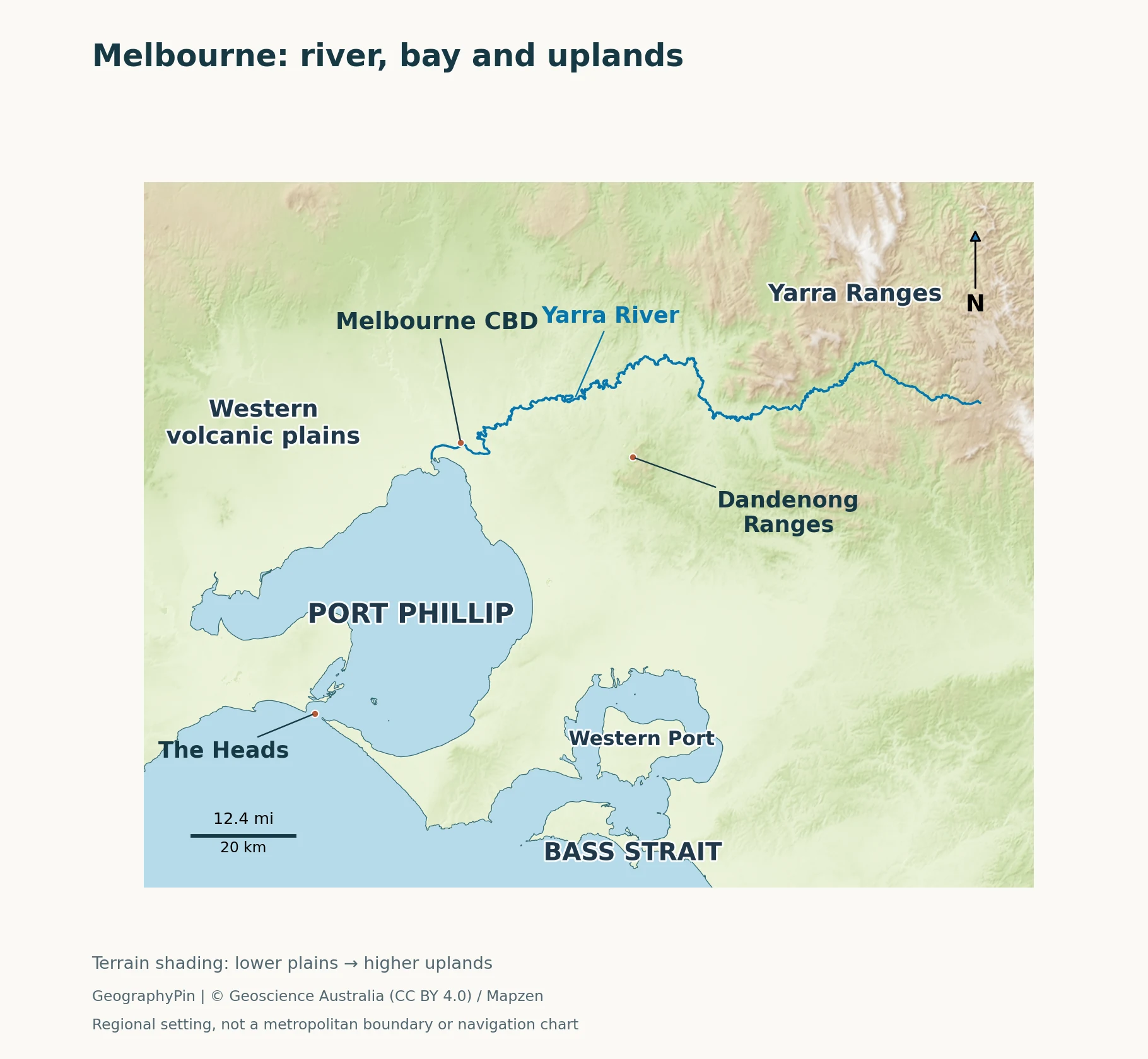
Use the bay as your first landmark, then trace the lower Yarra to the city and the river valley farther east. The relief distinguishes the low western landscape from the higher eastern and northeastern country. A regional physical map is not a map of municipal or metropolitan statistical boundaries.
Read the city through water and relief
Three different geographic questions work together here: where the built-up area lies, where rivers drain, and how the ground rises. A city boundary answers the first only partly. A drainage divide answers the second, while elevation data help answer the third. Our explanation of physical geography introduces this distinction between landforms, water and human settlement.
2. The Yarra links the uplands, suburbs and bay
From a forested catchment to an urban estuary
The Yarra runs from the forested uplands east of Melbourne through the Yarra Valley and the metropolitan area before reaching Port Phillip. Melbourne Water gives its length as about 150 miles (242 km). That is the winding river course, not the straight-line distance from its source to the coast.
Its surroundings change along the way. Upper reaches pass through mountain forest, the middle valley includes agricultural land, and the lower river flows through a heavily urbanized landscape. A photograph of the downtown waterfront therefore shows one part of a much larger river system, not the conditions along its entire course.
Near the coast, the river becomes an estuary: freshwater moving downstream meets salt water entering from the bay. The lower Yarra should not be pictured as a freshwater channel separated completely from the sea. Its muddy appearance also needs care in interpretation. Fine suspended sediment can color the water brown; color alone is not a reliable test of pollution or water quality.
The river connects upstream and downstream places. Rain falling well away from the city can influence flows through urban reaches, while changes to land cover can affect runoff and sediment. That catchment perspective is more useful than examining the central riverfront in isolation.
Port Phillip is a bay, not a lake
Port Phillip opens southward to Bass Strait through the Heads, between Point Lonsdale on the western side and Point Nepean on the eastern side. This narrow connection is the key to reading the coastline. The bay can look almost enclosed on a regional map, but it remains connected to the sea.
The entrance is also quite different from the broad water farther north. Headlands, reefs and channels constrain movement through it, and tidal streams can be strong. The map identifies the geographic connection only; it is not a nautical chart or guidance for navigating the entrance. For orientation, remember the sequence: Yarra River, Port Phillip, the Heads, then Bass Strait.
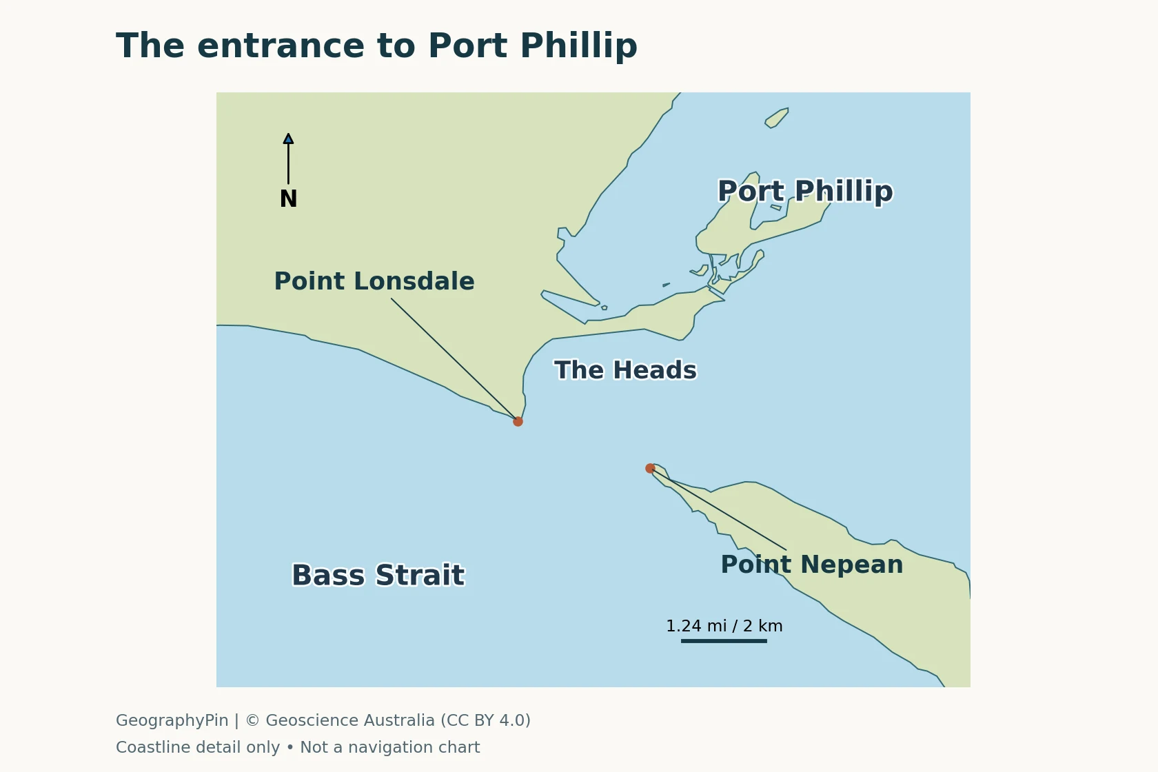
The entrance close-up uses a different scale from the regional map. Point Lonsdale and Point Nepean mark opposite sides of the connection, with Port Phillip inside and Bass Strait outside.
3. Western plains and eastern hills give Melbourne contrasting settings
The volcanic plains west of the city
Western Melbourne meets the eastern part of Victoria’s extensive volcanic plains. Repeated lava flows helped create a broad, gently undulating landscape, with volcanic hills interrupting the lower ground. “Plain” does not mean a perfectly level surface, nor does it mean every rock or soil beneath the western suburbs has the same origin.
This terrain contrasts with the more pronounced relief toward the east. On a map, compare the broad western surface with the closely spaced valleys and ridges of the uplands. The contrast is visible at regional scale even though individual neighborhoods on either side can have local slopes, cuttings and creek valleys.
A volcanic landscape also should not be confused with a city built around one active central cone. Melbourne’s western setting reflects a wider history of lava flows and landscape development. Naming the plains describes that regional landform; it does not assign a volcanic hazard level to an address.
The Dandenong and Yarra ranges to the east
The Dandenong Ranges rise east of the main urban area, with steep, forested volcanic hills. Parks Victoria describes mountain ash forest, fern-filled environments and waterfalls there. Farther east and northeast, the Yarra Ranges form part of the higher country associated with the river’s upper catchment.
The Dandenong Ranges and Yarra Ranges are related to Melbourne’s eastern setting, but they are not simply two names for the same ridge. Likewise, the Dandenong Ranges should not be confused with the lower suburban center of Dandenong. The shared name can hide a substantial difference in landscape.
Relief matters because water moves downhill and valleys organize drainage. It also changes the experience of the metropolitan fringe: an eastern forested hillside, a western plain and a bayside suburb occupy different physical settings even when all are described broadly as Melbourne. An elevation map shows this contrast without needing to invent a sharp boundary between “flat Melbourne” and “hilly Melbourne.”
4. Urban growth crosses more than one catchment
Not every Melbourne stream is part of the Yarra
The Yarra is the best-known river associated with central Melbourne, but it is not the only drainage system serving the wider region. Melbourne Water identifies five major catchments across its Port Phillip and Western Port region: Werribee, Maribyrnong, Yarra, Dandenong and Western Port. Their waters reach Port Phillip or Western Port through different systems.
This wider water-management region is not the same boundary as Greater Melbourne in population statistics. That distinction prevents two common mistakes: treating every metropolitan creek as a Yarra tributary, and assuming the entire surrounding region drains into Port Phillip. Western Port, east of the Mornington Peninsula, is a separate coastal water body.
As suburbs expand, catchments remain connected across municipal boundaries. Roofs, roads and other hard surfaces can change how quickly water reaches drains and streams. Flood management therefore requires attention to the upstream drainage area as well as the place where water collects. A citywide description cannot substitute for a local flood map.
Drinking water depends on land beyond the suburbs
Melbourne’s drinking-water supply relies mainly on reservoirs, supplemented by the Victorian Desalination Plant. Much of the reservoir water comes from protected catchments north and east of the city. These are landscapes managed for water supply, not simply undeveloped spaces waiting to become suburbs.
Catchment protection limits contamination before water reaches storage and treatment systems. Some supply catchments are protected from public entry, while others include a mixture of forest, farmland and managed public areas. A green patch on a map does not by itself indicate a public recreation area. The important geographic connection is that water used in the metropolitan area can originate beyond its built-up edge.
5. Key facts: match each number to the right geography
| Feature | Meaning |
|---|---|
| Central setting | Lower Yarra River, near the northern end of Port Phillip. |
| Connection to the sea | Port Phillip connects to Bass Strait through the Heads. |
| Main west–east contrast | Western volcanic plains versus eastern hills and ranges; local terrain varies. |
| Population reference | About 5.44 million estimated residents, Greater Melbourne GCCSA, June 30, 2025. |
| River length reference | About 150 miles (242 km), the Yarra’s course as reported by Melbourne Water. |
| Boundary caution | Municipality, metropolitan statistical area and water-management catchments are different areas. |
These distinctions help when comparing Melbourne with other cities. Use equivalent boundaries and dates for population, and distinguish a whole river’s length from the reach inside a city. The physical map is best used to understand relationships between land and water, not to measure the population of a shaded area.
Frequently Asked Questions
Is Melbourne on the ocean or on a bay?
Central Melbourne is beside the lower Yarra near Port Phillip, a marine bay connected to Bass Strait. The bay’s narrow southern entrance separates its broad sheltered water from the strait outside.
Is Melbourne flat?
Parts of the metropolitan area occupy low plains, especially toward the west, but Melbourne is not uniformly flat. River valleys, local hills and the eastern ranges give the wider region considerable variation in relief.
What Did We Learn Today?
Melbourne makes more sense as a connected landscape than as a skyline alone. The Yarra links upland and urban environments, Port Phillip connects the city’s waterfront to Bass Strait, and western plains contrast with eastern hills. Population describes a defined statistical region, while rivers and water-supply catchments follow different boundaries. Keeping those scales separate makes both the map and the facts easier to understand.
Sources & Data Notes
Population uses the ABS Greater Melbourne GCCSA estimate for June 30, 2025, rounded to two decimal places in millions. It does not describe the City of Melbourne municipality. River length follows Melbourne Water and is approximate. Catchment-management boundaries and metropolitan statistical boundaries serve different purposes.
- ABS: capital-city population, 2024–25 and regional population definitions.
- Victorian Government: Melbourne City Council.
- Melbourne Water: Yarra River, regional catchments and water-supply catchments.
- Ecolinc: Western Volcanic Plains; Parks Victoria: Dandenong Ranges.
- ATSB: Port Phillip entrance setting, report MO-2023-003, geographic background.
- Melbourne Water: urban development and stormwater.
Maps: GeographyPin cartography using Geoscience Australia topographic coastline and river data, © Commonwealth of Australia (Geoscience Australia) 2016, CC BY 4.0. Regional relief uses Mapzen Terrain Tiles via AWS, including NASA SRTM, USGS and other provider-listed elevation sources. The regional map and entrance close-up use different scales; landform labels are general locators, not surveyed boundaries. Water is shown separately from land; neither figure is a navigation chart.
Featured photograph: NASA / Don Pettit, October 9, 2024; resized and converted to WebP. The nighttime photograph illustrates the urban pattern, not a surveyed city boundary. No NASA endorsement is implied.